Showing 2831 items matching "transport - roads"
-
 Halls Gap & Grampians Historical Society
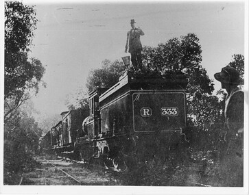
Photograph - B/W, C 1882
Occasional picnic trains took large groups of visitors to the base of the mountain range & sometimes as far as the quarry. Other journeys terminated at Fyan's Creek station on the south side of Mt. Dryden. Most trips were Sunday School & church outings - some on the annual Good Friday picnic day. spring was also a popular time.Photo shows train at siding. Man standing on engine roof with bucket in hand; woman in right-hand corner looking on; passenger standing at open carriage door. R 333 written on back of engine car. Engine turned back to front.transport, trains -
 Halls Gap & Grampians Historical Society
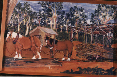
Photograph - Coloured, Early 20th C
A tramline was built to bring logs down from a mill up on Stoney Creek. The tramline was made of timber and the trolleys of logs were pulled as afr as possible by horse and then a driver would ride the logs down to the flat land below pulling a brake when nearing the end. (Close to site of present Primary School).Photo is a copy of Anne Borella (nee Nicholson) depicting the haulage of timber along a tramline. Two horses are pulling a trolley while a driver stands on the load with the wheelbrake ready.transport, horse drawn, structures, tramway -
 Halls Gap & Grampians Historical Society
Photograph - B/W
... 117-119 Grampians Road Halls Gap grampians TRANSPORT Buses ...Photo shows two buses - one Provincial Roadways, the other Ansett Road. Provincial Roadways bus is being pushed by front-end loaded.Writing on back - Zumsteins's camping. Provincial Roadways bus in trouble.transport, buses -
 Halls Gap & Grampians Historical Society
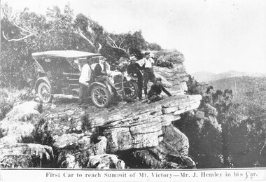
Photograph
Photo shows the first car (a Buick) to reach summit of Mt Victory. The car was owned by Mr J Hemley. One copy is a slide in slide box 303.Photo shows a car parked on rocky outcrop. Five men are standing near the car.First car to reach summit of Mt Victory - Mr J. Hemley in his cartransport, cars -
 Halls Gap & Grampians Historical Society
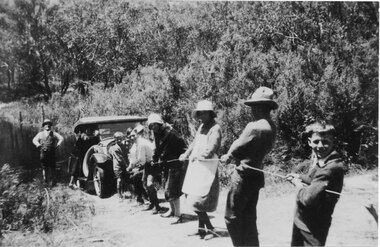
Photograph - B/W, C 1920s
... 117-119 Grampians Road Halls Gap grampians TRANSPORT Cars ...Photo shows a group of people pulling a car by rope out of the Wannon River. There are six adults and three children in the photo.transport, cars -
 Halls Gap & Grampians Historical Society
Postcard - B/W
Photo shows Jack & George McKeon. Both brothers worked at Chandler's Saw Mill. One copy is a transparency held at slide box no. 235.Photo shows Jack and George McKeon and a third man with bullock team, hauling a load of pipes.people, mckeon, transport, bullock team -
 Halls Gap & Grampians Historical Society
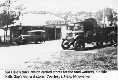
Photograph - B/W, C 1930s
... for the road workers. BUILDINGS Shops TRANSPORT Trucks "Sid Field's ...Sid Field's truck outside Halls Gap General Store on his trip to pick up stores for the road workers.The photo shows a small truck with a man standing beside it. In the background is the Halls Gap Store with a car parked in front of it."Sid Field's truck, which carried stores for the road workers, outside Halls Gap General store. Courtesy I. Field, Mirranatwa." Typed on a sheet of paper and attached so that it shows beneath the photo.buildings, shops, transport, trucks -
 Halls Gap & Grampians Historical Society
Photograph, C 1930s
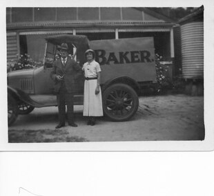
Wilfred (Fred) Warren and niece Ida Warren (who later married Robert Greer). They are shown standing in front of Warren's Bakery van, which is parked in front of their house. Warren bakery was started in 1929 by John Warren, his wife Florence, their daughter Ida and an aunt Miss Vine. see Bridging the Gap p.58A man and a woman standing in front of a truck marked "Baker.". There is a house in the background.people, warren, transport, trucks -
 Halls Gap & Grampians Historical Society
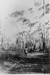
Photograph - B/W, C 1880s
This photo is of the road approaching Delley's Bridge. It shows methods of transport and the access route to Halls Gap in the late 19th Century.A man with a walking stick walking away from the camera on a rutted dirt road through trees and bush. Another man is approaching from the opposite direction on horseback.access routes, roads -
 Halls Gap & Grampians Historical Society
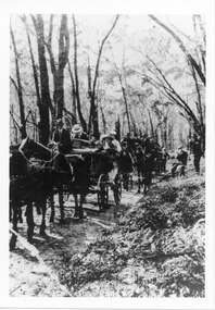
Photograph - B/W, C 1900
A group of people on the Stawell-Halls Gap road on their way to an outing at the turn of the 19th century.access routes, jinker track, transport, horse drawn -
 Halls Gap & Grampians Historical Society
Photograph - Coloured, C 1960s (?)
Stone was transported out of quarry by rail. Some sections of track are still visible at the Quarry.structures, train tracks, quarrying, mt difficult quarry -
 Halls Gap & Grampians Historical Society
Photograph - B/W
The photo shows a bullock team carting honey to Horsham.Photo shows a bullock team pulling a loaded cart. The team is standing on the side of a wide, unsurfaced road. There are two men standing in front of the cart.transport, bullock team -
 Halls Gap & Grampians Historical Society
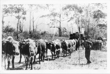
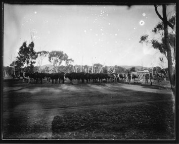
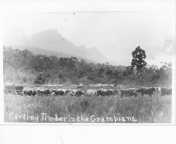
Photograph - B/W
The photo shows a bullock team on Dunkeld Road, towards Yarram Gap.The photo shows a team of bullocks pulling a cart loaded with timber. There is a man standing directly behind the team. Further back a buggy carrying two people can be seen. There are pointy peaks rising in the background.timber industries, logging, transport, bullock team -
 Halls Gap & Grampians Historical Society
Photograph - B/W, C 1910
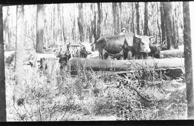
The photo is of an unknown bullock team in the Grampians. Note: The photo may have been taken by Guy E. Neate of "Rosebank" on Neates Road in the Victoria Valley, however Guy Neate did not buy that property until June 1926 (see the book "Water Between the Hills".The photo shows a team of bullocks surrounded by logs in a clearing in the bush. A man is just visible behind the bullocks.timber industries, logging, transport, bullock team -
 Halls Gap & Grampians Historical Society
Photograph - B/W, C 1932
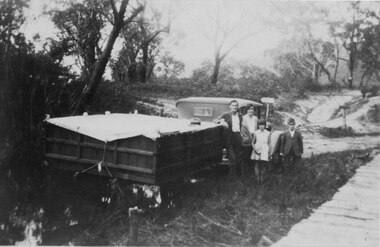
A family on holiday in the Grampians. The deep wagon is an early form of caravan, which folded down and was ready to erect when a site was found. The man is Jack Diamond from Donald.The photo shows a family (a man, a woman, a girl and a boy) standing beside an old car pulling a deep, wooden wagon covered by a tarpaulin. A mans hat sits on the tarpaulin near the man's elbow.The wagon appears to be standing in water and there is a wooden slat surfaced bridge ortrestle to the right. A track with two signposts is in front of the car and there is thin bush in the background.recreation, camping, transport, cars -
 Halls Gap & Grampians Historical Society
Photograph - B/W
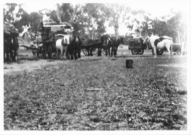
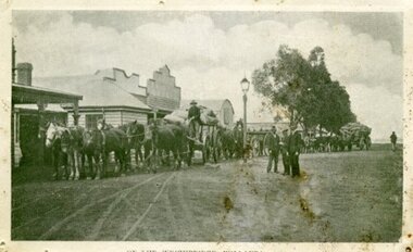
... 117-119 Grampians Road Halls Gap grampians TRANSPORT Horse ...The photo shows three groups of horses harnessed to carts. The two of the carts to the left have high loads and the carts to the right are close together and appear unladen. To the far right is a box cart hitcheed to a car and in front of this is a saddled, light coloured horse/pony. The horse and carts, car and saddle horse are placed around the edge of a clearing with trees behind them. There is a tin or box in the centre, right of the clearing.transport, horse drawn -
 Halls Gap & Grampians Historical Society
Photograph - B/W, C 1932-33
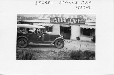
A photo of the Taylor's Store and Cafe in Halls Gap. The car, a 1926 Buick, belonged to the donor's father and the photo was taken by the donor's parents.A photo mounted on white cardboard shows a store with Taylor's painted on the corrugated iron roof. A sign attached to the roof reads "Store & Cafe" and advertises availability of Kodak Supplies, Circulating Library, Soft Drinks and Tobacco. To the left of the photo, in front of the store, is an old car with the drivers side door open and a woman seated in the passenger seat looking towards the camera."Store - Halls Gap 1932-33" written on top of mount board.buildings, shops, transport, cars -
 Halls Gap & Grampians Historical Society
Photograph - B/W
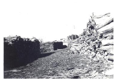
Reverse----- Stacks of wattle bark bundlesBlack and White photo showing stacks of bundled wattle bark ready for transporting to mill. Weather board house in far distance.Reverse----- Stacks of wattle bark bundlestimber industries, wattlebark stripping -
 Halls Gap & Grampians Historical Society
Photograph - B/W
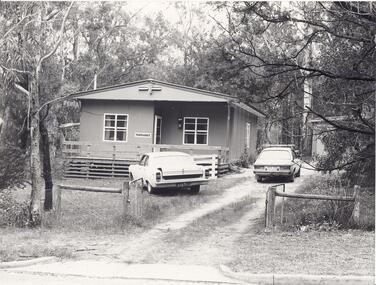
"Yarrabee" a holiday house in Halls Gap which was formerly a staff house for the construction of Bellfield Dam. A number of this houses were transported from job to job.A fibro cement house of simple rectangular construction, a low pitched roof ,sashed windows, a garage appears at the end of the driveway. Two cars are parked in driveway, gum trees surround the house. buildings, houses -
 Halls Gap & Grampians Historical Society
Photograph - Coloured
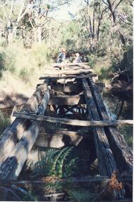
An old bridge on the Heatherlie Quarry rail line at Back Creek, this line was used to transport sandstone from the quarry to Stawell.Photo shows an old bridge with 3 adults at the end, one male standing and 2 adults sitting. The bridge consists of large wooden beams,cross beams and supports .water can be seen at the bottom of the depression. Bush surrounds the bridge.structures, bridges -
 Halls Gap & Grampians Historical Society
Photograph - B/W, C 1920s ?
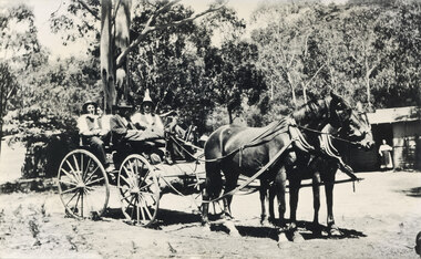
c 1920s ? The cottage was known as "Gray's Cottage" and was one of a number in the campground that could be rented for the holidaysPhoto mshows four men in a gig drawn by two horses. A bundle (camping gear) is stowed in front of the gig. A hurricane lamp can be seen on top of the hear in front. On the right a building can be seen, with a woman wearing an apron in the doorway. The building front (presumably the verandah) is weatherboard with the upper half being lattice. Another building (? shed) can be seen vaguely on the left. Large gums and bush are seen in the background.recreation, camping, transport, horse drawn -
 Ararat & District Historical Society (operating the Langi Morgala Museum)
Photograph, Willaura Weighbridge
This photograph shows a point in time (late 19C) at the Willaura weighbridge which no longer exists. The weighbridge was part of a transportation system that included horses, wagons, silos, and trains and when this photograph was taken, the weighbridge was crowded with people and wagons. Black and white photograph of a streetscape with wide dirt roads, some early European buildings and three supply wagons. Two are horse drawn and the third is pulled by bullock, with six men driving the wagons and standing in the roadway. Front: "Willaura Weighbridge"willaura, weighbridge, postcard, horses, wagons, wool, transport -
 Eltham District Historical Society Inc
Photograph, In memory of David Christmas
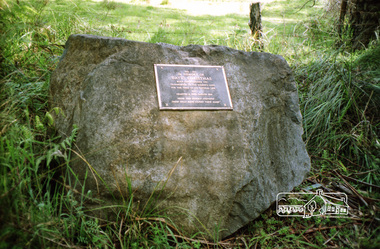
The David Christmas memorial is situated on the south side of One Tree Hill Road, at Watsons Creek. As a young man, Welshman David Christmas had been transported to Van Dienman's Land for a relatively minor offence. In 1836, having received a pardon, he came to Port Phillip, where, in 1842, he was hired as a shepherd by district pioneer, Joseph Stevenson. In 1992, a roadside plaque commemorating the shepherd who gave his name to the district was set in place over his presumed bush gravesite. The plaque was unveiled by two of Stevenson's grandsons, Bruce and Don Ness. FROM: Christmas Hills Past and Present, Yarra Glen & District Historical Society, 2004. 1842-1992 In memory of David Christmas born Cardiganshire 1797 Transported to Van Dieman's Land for the term of his natural life 1822 Granted a free pardon 1826 "From this humble shepherd these hills have gained their name" Roll of 35mm colour negative film, 1 strip (2 frames)Fuji 200david christmas, christmas hills, memorials, watsons creek, plaque -
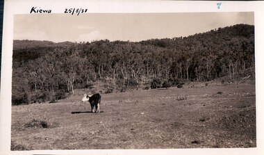
 Kiewa Valley Historical Society
Black and white photograph of farmland, Kiewa, 25/8/38, circa 1938
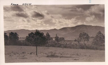
This photograph was taken in August, 1938 some eight years prior to the establishment of Mt. Beauty as a township. The area was still being used for grazing, and the land was eventually acquired from the local land owners by the State Electricity Commission. The construction of the road, from Tawonga to the High Plains, was commenced in April of this year. This allowed men and heavy equipment to be transported to the work sites for the construction of the Kiewa Hydro Electric Scheme This photograph is important as it shows the upper Kiewa Valley as it was before the establishment of the town of Mt. Beauty. The land has been cleared of natural growth and has been used for grazing cattle. By 1946 housing construction had commenced for the new town of Mt. Beauty and by 1948 street construction in the southern part of the town was completed as far as Hill Street.A black and white photograph of farmland with Mt. Emu in the background. This has been taken from where Mt. Beauty township now stands prior to road making and the erection of houses. A line of trees below the hill line indicates the position of the East Kiewa River. (No. 5 in a set of 8) Handwritten in black ink on the upper left corner of the photograph is the inscription 'Kiewa 25/8/38' and the number 5 has been stamped on the upper right hand corner. On the back is the word 'Velox' which is the name of the photographic paper on which the photo was developed.road construction, kiewa, tawonga, mt. beauty, secv -
 Kiewa Valley Historical Society
Black and white photograph of farmland, Kiewa, 25/8/38, circa 1938
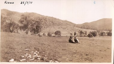
This photograph was taken in August, 1938 at the time of road making in the area and some eight years prior to the establishment of Mt. Beauty township. The area was still being used for grazing, and the land was eventually acquired from the local land owners by the State Electricity Commission. The construction of the road, from Tawonga to the High Plains, was commenced in April of this year. This allowed men and heavy equipment to be transported to the work sites for the construction of the Kiewa Hydro Electric Scheme. An important photograph as it shows the upper Kiewa Valley as it was before the establishment of the town of Mt. Beauty. The land had been cleared of natural growth and has been used for grazing cattle. By 1946 housing construction had commenced for the new town of Mt. Beauty and by 1948 street construction in the southern part of the town was completed as far as Hill Street.A black and white photograph taken in the upper Kiewa Valley showing farmland with a group of three unidentified people sitting on the grass.Handwritten in black ink is the inscription 'Kiewa 25/8/1938'. In the right corner of the photograph has been stamped the number 6. On the back in a circle, some 14mm across, are the words 'Kodak Print'. The word Velox is also printed on the back.kiewa, mt. beauty, construction, grazing, secv -
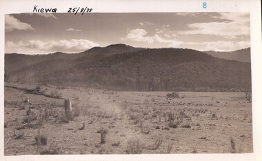
 Kiewa Valley Historical Society
Black and white photograph of farmland, Kiewa, 25/8/38, circa 1938
This photograph was taken in August, 1938, some eight years prior to the establishment of Mt. Beauty a a township. The area was still being used for grazing, and the land was eventually acquired from the local land owners by the State Electricity Commission. The construction of the road, from Tawonga to the High Plains, was commenced in April, 1938 and this photograph was taken August, 1938. This allowed men and heavy equipment to be transported to the work sites for the construction of the Kiewa Hydro Electric Scheme. Prior to this access was by bridle trail, either on horse back or on foot. By 1946 housing construction had commenced for the new town of Mt. Beauty and by 1948 street construction in the southern part of the town was completed as far as Hill Street.This photograph is important as it shows the upper Kiewa Valley as it was before the establishment of the town of Mt. Beauty. The land has been cleared of natural vegetation to allow grazing of cattle. Black and white photograph of grazing farmland with one animal standing in the paddock. The area could possibly be where the golf course now stands with the road to the high plains not yet commenced.Handwritten in the upper left hand corner 'Kiewa 25/8/38'. The number 7 has been stamped in the upper right hand corner. It is part of a set of 8 photographs. On the back are the words Velox repeated several times, indicating the type of photographic papergrazing, kiewa, mt. beauty, secv -
 Kiewa Valley Historical Society
Photograph Farm Land, Kiewa, 25/8/38, circa 1938
This photograph was taken in august, 1938 some eight years prior to the establishment of Mt. Beauty as a township. The area was still being used for grazing cattle and the land was eventually acquired from the local land owners by the State Electricity Commission. The construction of the road, from Tawonga to the High Plains, was commenced in April of 1938. This allowed men and heavy equipment to be transported to the work sites for the construction of the Kiewa Hydro Electric Scheme. Prior to this access was by bridle trail, either on horse back or by foot. By 1946 housing construction had commenced for the new town of Mt. Beauty and by 1948 street construction in the southern part of the town was completed as far as Hill Street.This is an important photograph as it shows the upper Kiewa Valley and the site for Mt. Beauty as it was before the establishment of the town. The land has been cleared of natural vegetation and used for grazing cattle.Black and white photograph of farmland, cattle in the distance, hills in the backgroundHandwritten in the upper left hand corner, in black ink, 'Kiewa 25/8/38'. The number 8 has been stamped in the upper right hand side of the photograph. On the back have been stamped the words Velox, indicating the type of photographic paper.kiewa, mt. beauty, construction, grazing, secv -
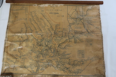 Kiewa Valley Historical Society
Map - Railway Map of Victoria, Amended to 1/11/1945
... station to the Kiewa Valley but road transport was used more often ...Railways began in the 1850s and were privately owned and operated. Later they were taken over by the Victorian Government reaching a peak in the early 1940s.Steam trains were followed by electric trains with both running after the war in 1945.Bright was the closest station to the Kiewa Valley but road transport was used more often as the Kiewa Valley Highway was improved with the construction of the Kiewa Hydro Electric Scheme. To travel to Melbourne or Sydney by train residents went via Wodonga/Albury where they also did their shopping.Plastic on parchment with detailed railway routes (in green) across Victoria including each district's 'Road Foremen' and 'Depots'. There is a length of flat wood attached by 10 tacks across the top of the mapvictorian railways 1945, trains, transport -
 4th/19th Prince of Wales's Light Horse Regiment Unit History Room
Booklet (2 copies), Department of Shipping and Transport, Commonwealth Explosives Transport Committee, Notes for the Guidance of Drivers and Attendants engaged in the Transportation of Commonwealth Explosives, July 1967
Intrstructions for Army driversA soft covered booklet issued as a guide for all drivers and attendants engaged in the transportation of explosives by road.7610-66-027-8250 Badge of Commonwealth of Australiaexplosives, transport, instructions -
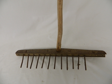 Kiewa Valley Historical Society
Rake - Tea Tree, mid to late 1900's
This "homemade rake" is constructed from a branch of a tea tree. This item demonstrates that in the mid to late 1800's the isolation of the Kiewa Valley was more pronounced than during the early 1900's. The availability of gardening implements to the residences within the Kiewa Valley was scarce to non existence. with the upgrading of roads into the valley and the boost to the Valley's population (S.E.C. Kiewa Valley Hydro Electricity Scheme) transport into the valley, firstly via commercial Hawkers in their mobile caravans and later by commercial trucks. This "home made" rake is very significant because it highlights the ingenuity of local farmers and graziers in overcoming the semi isolation of the Kiewa Valley and its regions from the commercial availability of gardening implements enjoyed by gardeners in the towns and cities of the 1800's and the early 1900's. This "home made" garden rake highlights the ingenuity of the "Australian" character per se. A slice of this ingenuity can be seen by the amount of inventions, per capita, produced within Australia throughout its history.Handle is a long, stripped branch of tea tree. The head of the rake is a 2.3 cm. wide piece of wood, compressed between two 0.5 cm. pieces of metal joined with bolts, nuts and rivets. The holes drilled into the wood hold metal tines 10.5 cms. high. There should be 16 tines but 4 are missing. This type of rake is/ was used in dairiestimber, dairy, farm, rural, implement