Showing 473 items
matching water works
-
 Kew Historical Society Inc
Map, MMBW, MMBW Plan No.65 Kew & Heidelberg, 1900-1910
The Melbourne and Metropolitan Board of Works (MMBW) was established by an act of the Victorian Parliament in 1890 to prepare for and to implement a sewerage and water reticulation system across what was then inner Melbourne, its surrounding and middle distance suburbs, including Kew. The MMBW was disbanded in 1991.The map collection of the Kew Historical Society has at its core the historic maps assembled and originally stored in the City Engineer's Department of the City of Kew. These include maps in a number of scales. The vast majority of maps were produced by the MMBW in the first two decades of the twentieth century, and are solid working maps, backed by linen for durability. These maps are historically significant to Kew, the City of Boroondara and to the history of the development of state utilities in Victoria. A number of the Kew maps have additional details added by former municipal officers, including the levels reached by various floods. As these were working documents, information was added to them long after the period of their initial production and distribution.Early map of part of the Borough of Kew, created in the first decade of the twentieth century, at a scale 160 ft to 1 inch. The map covers what was then the south central part of Kew, bordered on its north by Malmsbury Street, in the west by Florence Avenue, in the south by Barkers Road, and in the east by Princess Street. The map shows the extent of urban development by that time, prominent institutions and the outlines of built structures in the municipality. Contour lines were added in ink to the map at a later stage.MELBOURNE AND METROPOLITAN BOARD OF WORKS / PLAN NO. 65 / KEW & HEIDELBERGmelbourne & metropolitan board of works, mmbw maps, mmbw plans, borough of kew, cartography -
 Kew Historical Society Inc
Map, MMBW, MMBW Plan No.66 Kew, 1900-1910
The Melbourne and Metropolitan Board of Works (MMBW) was established by an act of the Victorian Parliament in 1890 to prepare for and to implement a sewerage and water reticulation system across what was then inner Melbourne, its surrounding and middle distance suburbs, including Kew. The MMBW was disbanded in 1991.The map collection of the Kew Historical Society has at its core the historic maps assembled and originally stored in the City Engineer's Department of the City of Kew. These include maps in a number of scales. The vast majority of maps were produced by the MMBW in the first two decades of the twentieth century, and are solid working maps, backed by linen for durability. These maps are historically significant to Kew, the City of Boroondara and to the history of the development of state utilities in Victoria. A number of the Kew maps have additional details added by former municipal officers, including the levels reached by various floods. As these were working documents, information was added to them long after the period of their initial production and distribution.Early map of part of the Borough of Kew, created in the first decade of the twentieth century, at a scale 160 ft to 1 inch. The map covers what was then the south eastern part of Kew, bordered on its north by Adeney Avenue, in the west by Sackville Street, in the south by Barkers Road, and in the east by Burke Road. The map shows the extent of urban development by that time, prominent institutions and the outlines of built structures in the municipality. Contour lines were added in ink to the map at a later stage.MELBOURNE AND METROPOLITAN BOARD OF WORKS / PLAN NO. 66 / KEW melbourne & metropolitan board of works, mmbw maps, mmbw plans, borough of kew, cartography -
 Kew Historical Society Inc
Map, MMBW, MMBW Plan No.67 Kew, 1900-1910
The Melbourne and Metropolitan Board of Works (MMBW) was established by an act of the Victorian Parliament in 1890 to prepare for and to implement a sewerage and water reticulation system across what was then inner Melbourne, its surrounding and middle distance suburbs, including Kew. The MMBW was disbanded in 1991.The map collection of the Kew Historical Society has at its core the historic maps assembled and originally stored in the City Engineer's Department of the City of Kew. These include maps in a number of scales. The vast majority of maps were produced by the MMBW in the first two decades of the twentieth century, and are solid working maps, backed by linen for durability. These maps are historically significant to Kew, the City of Boroondara and to the history of the development of state utilities in Victoria. A number of the Kew maps have additional details added by former municipal officers, including the levels reached by various floods. As these were working documents, information was added to them long after the period of their initial production and distribution.Early map of part of the Borough of Kew, created in the first decade of the twentieth century, at a scale 160 ft to 1 inch. The map covers what was then the north central part of Kew, bordered on its north by the Outer Circle Railway Spruzen and Beresford Avenues, in the west by Princess Street, in the south by High Street, and in the east by (about) Belford Road. The map shows the extent of urban development by that time, prominent institutions and the outlines of built structures in the municipality. Contour lines were added in ink to the map at a later stage.MELBOURNE AND METROPOLITAN BOARD OF WORKS / PLAN NO. 67 / KEW melbourne & metropolitan board of works, mmbw maps, mmbw plans, borough of kew, cartography -
 Kew Historical Society Inc
Map, MMBW, MMBW Plan No.68 Kew, 1900-1910
The Melbourne and Metropolitan Board of Works (MMBW) was established by an act of the Victorian Parliament in 1890 to prepare for and to implement a sewerage and water reticulation system across what was then inner Melbourne, its surrounding and middle distance suburbs, including Kew. The MMBW was disbanded in 1991.The map collection of the Kew Historical Society has at its core the historic maps assembled and originally stored in the City Engineer's Department of the City of Kew. These include maps in a number of scales. The vast majority of maps were produced by the MMBW in the first two decades of the twentieth century, and are solid working maps, backed by linen for durability. These maps are historically significant to Kew, the City of Boroondara and to the history of the development of state utilities in Victoria. A number of the Kew maps have additional details added by former municipal officers, including the levels reached by various floods. As these were working documents, information was added to them long after the period of their initial production and distribution.Early map of part of the Borough of Kew, created in the first decade of the twentieth century, at a scale 160 ft to 1 inch. The map covers what was then the north central part of Kew, bordered in the north by Oak Avenue, in the west by the Yarra River and Connor's Creek, in the south by Beresford and Carnegie Avenues, and in the east by Glass's Creek and Burke Road. The map shows the extent of urban development by that time, prominent institutions and the outlines of built structures in the municipality. Contour lines and the levels of historic floods were added in ink to the map at a later stage.MELBOURNE AND METROPOLITAN BOARD OF WORKS / PLAN NO. 68 / KEW melbourne & metropolitan board of works, mmbw maps, mmbw plans, borough of kew, cartography -
 Kew Historical Society Inc
Map, MMBW, MMBW Plan No.117 Heidelberg & Kew, 1900-1910
The Melbourne and Metropolitan Board of Works (MMBW) was established by an act of the Victorian Parliament in 1890 to prepare for and to implement a sewerage and water reticulation system across what was then inner Melbourne, its surrounding and middle distance suburbs, including Kew. The MMBW was disbanded in 1991.The map collection of the Kew Historical Society has at its core the historic maps assembled and originally stored in the City Engineer's Department of the City of Kew. These include maps in a number of scales. The vast majority of maps were produced by the MMBW in the first two decades of the twentieth century, and are solid working maps, backed by linen for durability. These maps are historically significant to Kew, the City of Boroondara and to the history of the development of state utilities in Victoria. A number of the Kew maps have additional details added by former municipal officers, including the levels reached by various floods. As these were working documents, information was added to them long after the period of their initial production and distribution.Early map of part of the Borough of Kew, created in the early twentieth century, at a scale 160 ft to 1 inch. The map covers what was then the north eastern part of Kew showing the natural landscape and limited development on the south side of the Yarra River. In the Kew section, south of the river, the land is occupied currently by the Greenacres and Kew Golf Clubs. The map shows the extent of urban development by that time and the outlines of the few built structures in the municipality. The height above sea level of all parts of the landscape are indicated numerically in feet. Contour lines and the levels of historic floods were added in ink to the map at a later stage. MELBOURNE AND METROPOLITAN BOARD OF WORKS / PLAN NO. 117 / HEIDELBERG & KEW melbourne & metropolitan board of works, mmbw maps, borough of kew, cartography, mmbw plan no. 117, kew (vic.) -- maps, heidelberg (vic.) -- maps -
 Kew Historical Society Inc
Map, MMBW, River Yarra Beautification Schemes, c.1913
The Melbourne and Metropolitan Board of Works (MMBW) was established by an act of the Victorian Parliament in 1890 to prepare for and to implement a sewerage and water reticulation system across what was then inner Melbourne, its surrounding and middle distance suburbs, including Kew. The MMBW was disbanded in 1991.The map collection of the Kew Historical Society has at its core the historic maps assembled and originally stored in the City Engineer's Department of the City of Kew. These include maps in a number of scales. The vast majority of maps were produced by the MMBW in the first two decades of the twentieth century, and are solid working maps, backed by linen for durability. These maps are historically significant to Kew, the City of Boroondara and to the history of the development of state utilities in Victoria. A number of the Kew maps have additional details added by former municipal officers, including the levels reached by various floods. As these were working documents, information was added to them long after the period of their initial production and distribution.Map of the City of Kew showing part of the River Yarra Beautification Schemes. The map shows development to date and the flood levels reached in 1923 and 1924. This map may have been adapted from an earlier map, as most development in central Kew and Studley Park had occurred by this date yet numerous streets are not represented. Public buildings and institutions are clearly represented and named on the map as are significant public transport infrastructure (eg the Outer Circle railway).MELBOURNE AND METROPOLITAN BOARD OF WORKS / RIVER YARRA BEAUTIFICATION SCHEMES / SCHEME / SCALE 10 CHAINS TO AN INCHmelbourne & metropolitan board of works, mmbw maps, mmbw plans, city of kew, flood levels -- kew (vic.), cartography -
 Kew Historical Society Inc
Photograph - Flooding of the Yarra Valley at Kew East, 1974
Flooding of the Yarra Valley, including that section of the Yarra bordering Kew and Kew East in the north and west of the municipality, was a regular occurrence. Extreme flood events of the Yarra River are recorded to have occurred in 1891, 1901, 1916, 1923 and 1934. The Municipality of Kew's response to these floods was to enact planning decisions restricting residential development in flood prone areas following the floods of 1916, 1921 and 1934. While floods continued after the development of the Upper Yarra Reservoir (construction 1948-57), the regularity and extent of these inundations diminished. During the nineteenth century, the land abutting the south side of the Yarra in Kew was devoted to dairy farming. In the twentieth century, before and after the construction of the Eastern Freeway, much of this low-lying area was used as golf courses and public parks.Late example of the capacity of the Yarra Valley at Kew to flood, even though drainage works and the Upper Yarra Reservoir had reduced their regularity.Original black and white print photograph of the low-lying land at East Kew under floodwater on 16 May 1974. The vantage point of the photographer is Lister Street. In the photo, the fences of the Kilby Farm can be seen. Flooding was caused by overflowing water in Glass' Creek and the River Yarra. Annotation verso: "Hay's Paddock op No.30 Lister Street / 16 May 1974 11.50am / R.L. 46.04"hays paddock, floods, yarra river, glass' creek, lister street -
 Kew Historical Society Inc
Photograph - Flooding of the Yarra Valley at Kew East, 1974
Flooding of the Yarra Valley, including that section of the Yarra bordering Kew and Kew East in the north and west of the municipality, was a regular occurrence. Extreme flood events of the Yarra River are recorded to have occurred in 1891, 1901, 1916, 1923 and 1934. The Municipality of Kew's response to these floods was to enact planning decisions restricting residential development in flood prone areas following the floods of 1916, 1921 and 1934. While floods continued after the development of the Upper Yarra Reservoir (construction 1948-57), the regularity and extent of these inundations diminished. During the nineteenth century, the land abutting the south side of the Yarra in Kew was devoted to dairy farming. In the twentieth century, before and after the construction of the Eastern Freeway, much of this low-lying area was used as golf courses and public parks.Late example of the capacity of the Yarra Valley at Kew to flood, even though drainage works and the Upper Yarra Reservoir had reduced their regularity.Original black and white print photograph of the low-lying land at East Kew under floodwater on 16 May 1974. The vantage point of the photographer is Lister Street. Flooding was caused by overflowing water in Glass' Creek and the River Yarra. Annotation verso: "Lister Street looking north / Flood level / 16 May 1974 11.30am / R.L. 46.04"hays paddock, floods, yarra river, glass' creek, lister street -
 Kew Historical Society Inc
Photograph - Flooding of the Yarra Valley at Kew East, 1974
Flooding of the Yarra Valley, including that section of the Yarra bordering Kew and Kew East in the north and west of the municipality, was a regular occurrence. Extreme flood events of the Yarra River are recorded to have occurred in 1891, 1901, 1916, 1923 and 1934. The Municipality of Kew's response to these floods was to enact planning decisions restricting residential development in flood prone areas following the floods of 1916, 1921 and 1934. While floods continued after the development of the Upper Yarra Reservoir (construction 1948-57), the regularity and extent of these inundations diminished. During the nineteenth century, the land abutting the south side of the Yarra in Kew was devoted to dairy farming. In the twentieth century, before and after the construction of the Eastern Freeway, much of this low-lying area was used as golf courses and public parks.Late example of the capacity of the Yarra Valley at Kew to flood, even though drainage works and the Upper Yarra Reservoir had reduced their regularity.Original black and white print photograph of Hay's Paddock under floodwater on 16 May 1974. The vantage point of the photographer is Keystone Crescent looking east. Flooding was caused by overflowing water in Glass' Creek and the River Yarra. Annotation verso: "Keystone Cr looking east / 16 May 1974 11.50am"hays paddock, floods, yarra river, glass' creek -
 Kew Historical Society Inc
Photograph - Flooding of the Yarra Valley at Kew East, 1974
Flooding of the Yarra Valley, including that section of the Yarra bordering Kew and Kew East in the north and west of the municipality, was a regular occurrence. Extreme flood events of the Yarra River are recorded to have occurred in 1891, 1901, 1916, 1923 and 1934. The Municipality of Kew's response to these floods was to enact planning decisions restricting residential development in flood prone areas following the floods of 1916, 1921 and 1934. While floods continued after the development of the Upper Yarra Reservoir (construction 1948-57), the regularity and extent of these inundations diminished. During the nineteenth century, the land abutting the south side of the Yarra in Kew was devoted to dairy farming. In the twentieth century, before and after the construction of the Eastern Freeway, much of this low-lying area was used as golf courses and public parks.Late example of the capacity of the Yarra Valley at Kew to flood, even though drainage works and the Upper Yarra Reservoir had reduced their regularity.Original black and white print photograph of the low-lying land at East Kew under floodwater on 16 May 1974. The vantage point of the photographer is Lister Street. Flooding was caused by overflowing water in Glass' Creek and the River Yarra. Annotation verso: "Lister St looking same as No.3 / 16 May 1974 11.30"floods, yarra river, glass' creek, lister street -
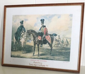 8th/13th Victorian Mounted Rifles Regimental Collection
Print - Framed gift from 8QRIH, Visiting the Outposts
The 8 Kings/Queens Royal Irish Hussars was affiliated with 8th Light Horse and later 8/13 Victorian Mounted Rifles. Gifts and visits were exchanged between the regiments. The artist, Henry Martens (b. 1790, London; d. 1868, London) was an English military illustrator and artist. He created works for the firm of Rudolf Ackermann who ran the Eclipse Sporting Gallery at 191 Regent Street. The majority of these depicted military uniforms and battle scenes, particularly images of the Sikh Wars and the Kaffir Wars. He worked mainly in water-colour although a few oil paintings do exist.Framed print of "Visiting the Outposts" by Henry Martens. This was a gift to 8/13 Victorian Mounted Rifles from its affiliated regiment 8 Queens Royal Irish Hussars in 1980.Presented by Queens Royal Irish Hussars 1980military, light horse, hussars, irish, martens, girt, affiliation -
 Stawell Historical Society Inc
Map, Plan of Works on No1 Reservoir, 1896
... grampians Stawell Water Plan of Works on No1 Reservoir Plan of Works ...Plan of Works on No1 Reservoirstawell, water -
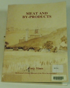 Melbourne's Living Museum of the West
Booklet, Melbourne's Living Museum of the West, Meat and By-Products, 1993
The meat industry and animal by-product works of Melbourne's West, in the series "Interpreting the Cultural Landscape", with the assistance of the Department of Planning and Development, VictoriaThe Australian Meat Preserving Company was established on the banks of the Maribyrnong River in 1870 on the site of boiling works dating from the 1840s.32 page booklet, A5, Cover illustration of Raleigh's boiling down works on the Maribyrnong River, from water-colour by Greeves C. 1850s Title: Meat and By-Products Author: Gary Vines Melbourne's Living Museum of the West Inc.western suburbs, meat industry -
 Surrey Hills Historical Society Collection
Photograph, The Surrey Dive, 1910, 1910
The Dive, in Elgar Road Park was formed when water seeped into the hole from which clay had been quarried for brick-making. In 1905 the Surrey Swimming Club was formed and carnivals were held regularly. This was the venue for training Olympic swimmers prior to the Council constructing an Olympic sized pool.Black and white photo with a grassy foreground beyond which the apex of the roof only of the clubhouse is visible. Beyond this the far bank of the Surrey Dive can be seen with fencing along its perimeter.surrey dive, swimming, sports and recreation, quarries, box hill brick works, elgar road park, surrey swimming club -
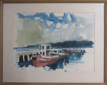 Federation University Art Collection
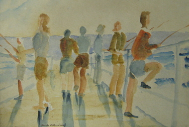
Painting - Artwork - Painting, [Boats] by Wes Walters
Wes WALTERS (06 August 1928 - 19 August 2014) Born Mildura, Victoria From 1940 t0 1945 Wes Walters attended the Ballarat High School. He then studied architecture at the Gordon Institute in Geelong, followed by art at the Ballarat School of Mines (a division of the Ballarat School of Mines). During his time at the Ballarat Technical Art School (later Federation University Australia) Walters studied under Neville Bunning and Taylor Kelloch, and was awarded the Ballarat Ladies Art Association Scholarship in 1948. He next moved to Melbourne to work as a commercial artist with the George Patterson advertising agency. Each evening Walters studied life drawing at the Victoria Artists’ Society and taught himself anatomy. Wes Walters excelled in both abstract and realist art. He won the Art Gallery of Ballarat’s Minnie Crouch Prize for watercolour art in 1953 and 1956. He won the prestigious Archibald Prize in 1879 for his portrait of Phillip Adams. This item is part of the Federation University Art Collection. The Art Collection features over 1000 works and was listed as a 'Ballarat Treasure' in 2007.Framed water colour showing boats along a pier.wes walters, watercolour, boats, vessels, sailing, available, alumni, ballarat technical art school -
 Federation University Art Collection
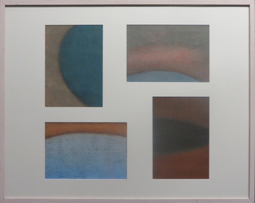
Drawing, 'Dam!' by Marie Purtill, 2001
This item is part of the Federation University Art Collection. The Art Collection features over 2000 works and was listed as a 'Ballarat Treasure' in 2007.Four framed pastel drawings mounted into one frameart, artwork, purtill, marie purtill, drawing, dam, water -
 Federation University Art Collection
Painting, Neville Bunning, 'Whiskey Distillery at Warrenheip via Dunnstown' by Neville Bunning
Neville BUNNING The whisky distillert was at te foot of Mt Warrenheip. Situated at tje site of a water spring, it later bacame Cottonwood Springs. The Warrenheip breweries near the spring were well established when Mr Henry Brind, opened Brind’s Distillery in 1864. At that tome they claimed to be the first of its kind in Australia, and “the only place where pot stilled whisky was manufactured in the colony.” This item is part of the Federation University Art Collection. The Art Collection features over 2000 works and was listed as a 'Ballarat Treasure' in 2007.Oil painting of an old distillery at Dunnstown.art, artwork, dunnstown, distillery, brinds, available, mt warrenheip, neville bunning -
 Federation University Art Collection
Oil and acrylic on canvas, Channing, Ian, 'Gondolas - Venice' by Ian Channing, 2000, 2000
This item is part of the Federation University Art Collection. The Art Collection features over 1000 works and was listed as a 'Ballarat Treasure' in 2007. If you are able to assist with information on this painting or artist please make contact via the comments link below. School of Human Movement Collectionart, artwork, ian channing, human movement collection, venice, gondola, water -
 Federation University Art Collection
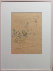
Drawing - Pencil ink & Water colour on paper, [Flower Study] by Sybil Craig
Sybil CRAIG (18 November 1901-09 September 1989) Born London, England Arrived Australia 1902 The National Gallery School, Melbourne, gave Craig a sound training for her popular flower and portrait studies. However, her association with leading modernists between the wars led her to pursue her art in a deliberately experimental and spontaneous way. Sybil Craig was the third woman appointed by the Australian War Memorial as an official war artist. She was the first woman to paint women working in the munitions’ factories. The Castlemaine Art Gallery & Historical Museum, held the first retrospective exhibition of Sybil Craig's in 2006. The exhibition highlighted her wonderful use of colour and design in a diverse range of media, techniques and subject matter. This item is part of the Federation University Art Collection. The Art Collection features over 2000 works and was listed as a 'Ballarat Treasure' in 2007.Framed sketches of plantsSigned lower left side "Sybil Craig"art, artwork, sybil craig, craig, flora, plants, flowers, available -
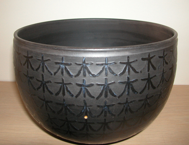 Federation University Art Collection
Ceramic - Blackware, 'From one seed a forest grows, water the seeds of joy first' by Petrus Spronk, 2004
Petrus SPRONK (1939- ) Born Netherlands, arrived Australia 1957. After arriving in Australia Petrus Spronk studied at the South Australian School of Art, majoring in ceramics and sculpture. After teaching and working in Western Australia he started working at the Ballarat College of Advanced Education in the late 1980s. This item is part of the Federation University Art Collection. The Art Collection features over 2000 works and was listed as a 'Ballarat Treasure' in 2007.Blackware potart, artwork, petrus spronk, spronk, blackware, ceramics, burnished -
 Federation University Art Collection
Photograph, Steinfort, Jessie, 'Mushrooms' by Jessie Steinfort, 1998
Jessie STEINFORT Steinfort was Studied Graphic Design at the University of Ballarat (later Federation University) After 12 years of working in design studios and advertising agencies, Steinfort is now a Senior Designer at Ogilvy Melbourne. And previously, he has been responsible for work on BMW & Mini, Carlton Football club, Melbourne Convention and Exhibition Centre, Melbourne Food & Wine Festival, AAMI, Yarra Valley Water, and Arts Centre Melbourne. From 2008 to 2011 Steinfort was lead designer and front-end web developer at clickDM (now HARDWIRE). Where he worked with such clients as HOSTPLUS, GSK, UniSuper and Swann Insurance. From 2000 to 2008 Steinfort was a designer at Mediation Communications working on print and interactive projects for; City of Melbourne, City of Greater Geelong, City of Port Phillip, Mentor Education, and ACMA. This item is part of the Federation University Art Collection. The Art Collection features over 2000 works and was listed as a 'Ballarat Treasure' in 2007. Framed photograph of three mushrooms in a black background. This work was won the 1998 Student Acquisition Award. If you can provide information on this artist or artwork please use the email link below. photography, foto, mushrooms, food, close up, macro, colour, photo, jessie steinfort, alumni, available -
Federation University Art Collection
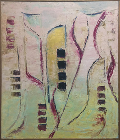
Painting - Acrylic on Linen, 'Tingari Cycle' by Walala Tjapaltjarri
Walala Tjapaltjarri (b. c1960) Language: Pintupi Region: Kiwirrkuru In late 1984 Walala Tjapaltjarri and several other members of the Pintupi Tribe walked out of the remote wilderness of the Gibson Desert in Western Australia and made contact for the first time with European society. Described as 'The Lost Tribe', he and his family created international headlines. Until that day in 1984, Walala and his family lived the traditional and nomadic life of a hunter-gatherer society. Their intimate knowledge of the land, its flora and fauna and waterholes allowed them to survive, as their ancestors had for thousands of years. It is this sacred landscape, and its significant sites, that Walala so strikingly describes in his paintings. His style is generally highlighted by a series of rectangles set against a monochrome background. He paints the Tingari Cycle (a series of sacred and secret mythological song cycles) which are associated with the artist's many dreaming sites - they are Wilkinkarra, Maruwa, Tarrku, Njami and Yarrawangu, to name a few. These Dreamings are the locations of significant rockholes, sandhills, sacred mountains and water soakages in the Gibson Desert. (http://www.kateowengallery.com/artists/Wal90/Walala-Tjapaltjarri.htm, accessed 18 May 2015) Walala Tjapaltjarri started painting in 1997. His earliest works were in a classical Tingari style usually reserved for body painting, ground painting and the decoration of traditional artifacts. Within a couple of months his painting had evolved into his own innovative style of work, including the abstraction of classical Pintupi designs which resulted in a highly graphic language to speak of his country and ceremonial sites. The rectangles so prominent in his paintings form both a physical and spiritual map establishing Walala as a discerning draughtsman for his ancient country. (http://www.kateowengallery.com/artists/Wal90/Walala-Tjapaltjarri.htm, accessed 18 May 2015) This item is part of the Federation University Art Collection. The Art Collection features over 1000 works and was listed as a 'Ballarat Treasure' in 2007.Tingari Cycle - During the Tjukurrpa (Creation Era) Tingari ancestors beings gathered at a series of sites for Malliera (Initiation) Ceremonies. They travelled vast stretches of the country, performing rituals at specific sites that in turn created the diverse natural features of the environment. The Tingari men were accompanied by novices and usually followed by Tingari Women. The creation stories and rituals are venerated in the song cycles and ceremonies of today, forming part of the teachings of the post initiatory youths, whilst also providing explanations for contemporary customs. Walala Tjapaltjarri uses a highly personalised and minimal style to represent aspects of the sacred Tingari Cycle, an epic journey of Ancestors of the TJukurrpa (Creation Era). He paints aspects of the Tingari Cycle which are associated with the artist's many sacred sites - such as Wilkinkarra, Maruwa, Tarrku, Njami and Yarrawangu, to name a few. These are locations of significant rockholes, sandhills, sacred mountains and water soakages in the Gibson Desert. (http://www.kateowengallery.com/artists/Wal90/Walala-Tjapaltjarri.htm, accessed 18 May 2015)art, artwork, walala tjapaltjarri, aboriginal, dreaming, creation era, acrylic on linen, pintupi, kiwirrkuru, tingari, wilkinkarra, tarrku, njami, yarrawangu -
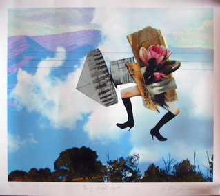 Federation University Art Collection
Work on paper - Photocollage, 'Being Ultra Light' by Rochelle Summerfield
Rochelle SUMMERFEILD Born Sydney, Australia This item is part of the Federation University Art Collection. The Art Collection features over 2000 works and was listed as a 'Ballarat Treasure' in 2007.Artists Statement: I am based in Northern NSW. My art practice is deeply influenced by my connections and experiences with the rivers and habitat where I live. Through drawing, paint, collage and digital media my work explores human relationships with riparian environments. Every day I see the undeniable beauty of our rivers as well as the ecological suffering of these riparian landscapes. Historical practices of land clearing, water politics and weed infestation put tremendous pressure on the Australian ecology. Disrupting traditional art forms, I combine them with new technologies to reveal some of the complexities behind human relationships with nature. With bold collagist experimentation, I combine numerous mediums to expose the small revelations between media. These juxtapositions open up the possibilities of reinventing different ways of being with the natural environment. Like the layers in my work, the issues surrounding our riverine environments are multifaceted and complex and begin with individual choices. I want to direct people’s attention to our rivers, to love, appreciate and reconnect with the natural environment. Human experience with nature is a fundamental part of our sense of self, health and well-being as well as community connection. (https://rochellesummerfield.com/about/, accessed 10 June 2020)art, artwork, rochell summerfield, printmaking, print council of australia -
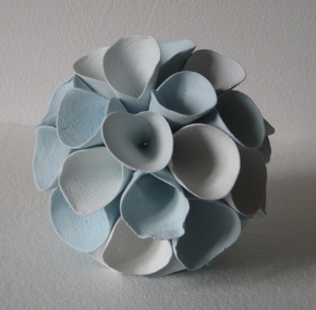 Federation University Art Collection
Ceramic - Ceramic - hand built & coloured porcelain, Lo, Li Feng, 'Natural Series (Earth, Sky, Water)', by Li-Feng Lo, 2010
My work is informed by a philosophical and spiritual engagement with Buddhist ideas, particularly in response to environmental concerns. In this work I wanted to challenge myself and explore the limits of clay material. Clay allowed me to express myself and free my mind. When I revisited Australia in 2010 form my residency, the natural environment here still was the best to me. Li-Feng LO (1967- ) Born Taiwan Ceramic artist Dr Li-Feng Lo completed a PhD at Monash University in 2008. She was a resident artist in the Federation University Arts Academy ceramics studio in 2010. Li-Feng worked with Southern Ice porcelain to create sculptural forms in response to environmental concerns. Her work is informed by a philosophical and spiritual engagement with Buddhist ideas. These works were exhibited in the exhibition 'AIRed' at the Post Office Gallery in 2011. This was a group exhibition showcasing the work of six artists who undertook residencies at the Arts Academy over a couple of years. This item is part of the Federation University Art Collection. The Art Collection features over 1000 works and was listed as a 'Ballarat Treasure' in 2007.Handbuilt (pinched), coloured porcelain form. Artist's Statement: In the beginning I try to use clay to achieve a dream-like quality by providing a feeling of flexibility like paper and fragility like glass. I was my artwork to the one with nature. Gift of the artist, 2010art, artwork, li-feng lo, ceramics, artist in residence, available, available ceramics, chinese -
 Federation University Art Collection
Watercolour on paper, 'School Holidays Pialba Queensland' by Neville Bunning
Neville Mirvane BUNNING (1902-1990) During World War Two he served with the RAAF. He was an Art Teacher at the Ballarat School of Mines from 05 February 1946 to 22 September 1964. Neville Bunning formed the Ballarat Artist's Society (later the Ballarat Society of Artists), a group that sponsored art and which invited modernist artists to speak to students and to the public of Ballarat. He also wrote a weekly column in the Ballarat Courier. Bunning produced a bust of Australian Prime Minister, The Right Honourable J.A. Lyons from Tasmania, who died in office. Bunning died in Subiaco, Western Australia on 29 April 1990. This item is part of the Federation University Art Collection. The Art Collection features over 1000 works and was listed as a 'Ballarat Treasure' in 2007.framed water colour LL signature Neville M Bunning art, artwork, neville bunning -
 Federation University Art Collection
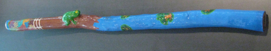
Artwork, other - Timber, acrylic paint, glass coat, beeswax, 'Frog Didgeridoo' by Peter Clarke, 2008
Peter CLARKE (1969- ) Gunditjamara (Lake Condah) Born Heywood, Victoria At two months old Peter Clarke was removed from his parents and placed in a Catholic boy's orphanage in Ballarat. The orphanage was closed and Peter was moved to a public orphanage where he discovered 'manners were not a necessity and you often had to take before you were ever given in this orphanage. ... This new orphanage was not a home for me but a prison of sadness and despair.' Disconnected from his country and lore Peter Clarke chose "my own path to land, county and water". Although his childhood memories are dark and bleak, he uses vibrant colours. This item is part of the Federation University Art Collection. The Art Collection features over 1000 works and was listed as a 'Ballarat Treasure' in 2007.Mallee Wood didgeridoo with vibrant colours. A natural wood imperfections have been used to emphasise what is recognisable as a frog. This work was purchased from the "My Art, My Life, My Colours' exhibition at the Federation University Post Office Gallery, May 2008.art, artwork, aboriginal, peter clarke, didgeridoo, stolen generation, st joseph's orphanage, sebastopol, my art, my life, my colours' exhibition, federation university post office gallery -
Federation University Art Collection
printmaking - Acquatint, Sara Bowen, 'Reeds/Juanbung' by Sara Bowen, 2008
Sara Bowen (1966 - ) Born England. Arrived Australia October 2006. Artists' Statement: Reeds/Juanbung is part of a series of prints centred on the looded country where the Murrumbidgee and Lachlan rivers meet. Unmapped and unmappable, with no fixed landmarks, it fascinates me. early drawings have evolved into abstracted curves of water that run over river banks and among islands of reeds. This item is part of the Federation University Art Collection. The Art Collection features over 1000 works and was listed as a 'Ballarat Treasure' in 2007.Sugarlift acquatint with blind embossing.art, artwork, sara bowen, etching, printmaking, embossing -
 Federation University Art Collection
Photograph - Artwork - photographic print, 'Ripple' by Michael Shiell, 2001
This work was undertaken in 2001 when the artist was undertaking an Honours year at the University of Ballarat Arts Academy (later Federation University). This item is a part of the Federation University School of Business Art Collection. The Federation University Art Collection features over 1000 works and was listed as a 'Ballarat Treasure' in 2007.Framed Digital Limited Edition Print by Michael Shiell. "The woven form was made at 'Blue Waters' near Creswick. I remember that I went out hoping to make something and I had a few mediocre starts but nothing really inspired was popping for me. Eventually I sat on the bank and started tossing little pebbles into the water. Finally the immediacy and ephemerality of the dissipating ripples struck me. I made the work by twisting and weaving the reeds which lined the banks of 'Blue Waters'. I then floated the rings together and managed to get a couple of quick photos before the work floated away and dissipated." (Michael Shiell)Edition: 1/10art, artwork, michael shiell, shiell, blue water, creswick, school of business collection, available, photography -
 Federation University Art Collection
Artwork, Dreaming Water
This item is part of the Federation University Art Collection. The Art Collection features over 2000 works and was listed as a 'Ballarat Treasure' in 2007.art, artwork, g. siluth -
Federation University Art Collection
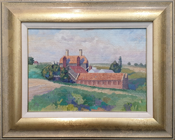
Water colour, Neville Bunning, [Red & Blue Landscape]
This item is part of the Federation University Art Collection. The Art Collection features over 1000 works and was listed as a 'Ballarat Treasure' in 2007.art, artwork