Showing 576 items matching "yarra yarra district"
-
 Eltham District Historical Society Inc
Ledger, Eltham Road District. Assessment for the Year ending Oct. 14th, 1861, 1860c
The Eltham Roads Board was established in 1856. This is a unique significant record of early settlers in the Shire of Eltham. One of 6 early rate books. This is among the oldest items in the EDHS collection. An article in the Eltham and Whittlesea Shires Advertiser Friday 21 Nov 1941 Page 5 titled: District's Early History states: "The first rate book which is still in existence at the Shire Office is for the year ending October 14, 1858 and is probably the best record possible to indicate the development of the district. At the time properties were rated as follows: Cultivated land. 6d. per acre; pasture land, 1d. per acre: estimated annual value of buildings, etc., 6d in the (pound). The total amount of rate recorded for the year was (pounds)153/14/8. Properties were described as being situated at Lower Plenty, Yarra Yarra, Eltham, Lower Eltham, Kangaroo Ground, Yarra Flats, Diamond Creek and the Yarra."Ledger with printed columns: Number, Name of Occupier, Description, Where situated, Cultivated land, Pasture land, Estimated annual value of buildings, Rate, Remarks, Arrears collected, excused, unoccupied, uncollected and amount actually collected. Ledger filled out by hand with 185 entries (not alphabetically arranged) and summary section. A number of blank pages are included. Inside cover includes pasted printed note: RATE OF ASSESSMENT AS FOLLOWS: Cultivated land 6d per acre Pasture land 2d per acre Unalienated Pasture Land 8d per Acre Estimated Annual Value of Buildings, &c., 6d. in the Pound eltham roads board, rate book, rate payers, transaction, pioneers, settlers, 1861, assessment ledger, eltham road district, public records office victoria (prov), rate books, shire of eltham archives -
 Eltham District Historical Society Inc
Ledger, Eltham Road District. Assessment for the Year ending Oct. 14th, 1862, 1861c
The Eltham Roads Board was established in 1856. This is a unique significant record of early settlers in the Shire of Eltham. One of 6 early rate books. This is among the oldest items in the EDHS collection. An article in the Eltham and Whittlesea Shires Advertiser Friday 21 Nov 1941 Page 5 titled: District's Early History states: "The first rate book which is still in existence at the Shire Office is for the year ending October 14, 1858 and is probably the best record possible to indicate the development of the district. At the time properties were rated as follows: Cultivated land. 6d. per acre; pasture land, 1d. per acre: estimated annual value of buildings, etc., 6d in the (pound). The total amount of rate recorded for the year was (pounds)153/14/8. Properties were described as being situated at Lower Plenty, Yarra Yarra, Eltham, Lower Eltham, Kangaroo Ground, Yarra Flats, Diamond Creek and the Yarra."Ledger with printed columns: Number, Name of Occupier, Description, Where situated, Cultivated land, Pasture land, Estimated annual value of buildings, Rate, Remarks, Arrears collected, excused, unoccupied, uncollected and amount actually collected. Ledger filled out by hand with 184 entries (not alphabetically arranged) and summary section. A number of blank pages are included. Inside cover includes pasted printed note: RATE OF ASSESSMENT AS FOLLOWS: Cultivated land 6d per acre Pasture land 1/2d per acre Unalienated Pasture Land 1/28 per Acre Estimated Annual Value of Buildings, &c., 6d. in the Pound eltham roads board, rate book, rate payers, transaction, pioneers, settlers, 1862, assessment ledger, eltham road district, public records office victoria (prov), rate books, shire of eltham archives -
 Eltham District Historical Society Inc
Ledger, Eltham Road District. Assessment for the Year ending Oct. 14th, 1863, 1862c
The Eltham Roads Board was established in 1856. This is a unique significant record of early settlers in the Shire of Eltham. One of 6 early rate books. This is among the oldest items in the EDHS collection. An article in the Eltham and Whittlesea Shires Advertiser Friday 21 Nov 1941 Page 5 titled: District's Early History states: "The first rate book which is still in existence at the Shire Office is for the year ending October 14, 1858 and is probably the best record possible to indicate the development of the district. At the time properties were rated as follows: Cultivated land. 6d. per acre; pasture land, 1d. per acre: estimated annual value of buildings, etc., 6d in the (pound). The total amount of rate recorded for the year was (pounds)153/14/8. Properties were described as being situated at Lower Plenty, Yarra Yarra, Eltham, Lower Eltham, Kangaroo Ground, Yarra Flats, Diamond Creek and the Yarra."Ledger with printed columns: Number, Name of Occupier, Description, Where situated, Cultivated land, Pasture land, Estimated annual value of buildings, Rate, Remarks, Arrears collected, excused, unoccupied, uncollected and amount actually collected. Ledger filled out by hand with 181 entries (not alphabetically arranged) and summary section. A number of blank pages are included. Inside cover includes pasted printed note: RATE OF ASSESSMENT AS FOLLOWS: Cultivated land 6d per acre Pasture land 1/2d per acre Unalienated Pasture Land 1/28 per Acre Estimated Annual Value of Buildings, &c., 6d. in the Pound eltham roads board, rate book, rate payers, transaction, pioneers, settlers, 1863, assessment ledger, eltham road district, public records office victoria (prov), rate books, shire of eltham archives -
 Eltham District Historical Society Inc
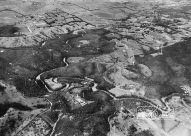
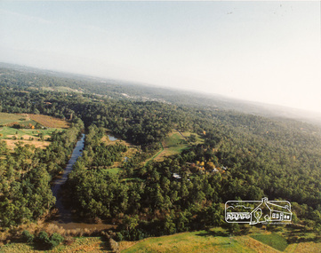
Photograph, Aerial view of Yarra River near Kangaroo Ground - Bend of Islands area
Sepia aerial view of Yarra river at Bend of Islands; Henley Road on left in foregroundbend of isles, kangaroo ground, yarra river, henley road -
 Eltham District Historical Society Inc
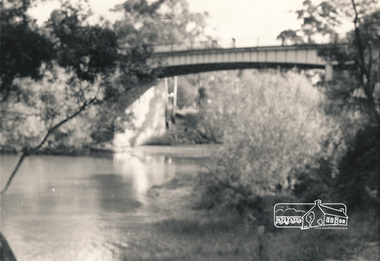
Photograph, Russell Yeoman, Warrandyte Bridge, c.1970, 1970c
Black and white photograph of Warrandyte Bridge over Yarra River c.1970warrandyte, yarra river, bridges -
 Eltham District Historical Society Inc
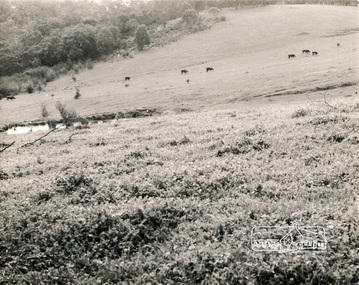
Photograph, George W. Bell, River Flats, Sweeneys Lane, 1960s
Black and white photograph Yarra River Flats, Sweeneys Lane, Eltham c.1960ssweeneys lane, yarra river, eltham, farming, george w bell collection -
 Eltham District Historical Society Inc
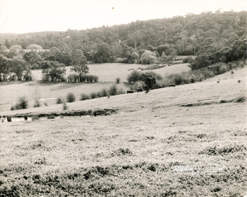
Photograph, George W. Bell, River Flats, Sweeneys Lane, 1960s
Black and white photograph of Yarra River Flats, Sweeneys Lane, Eltham c.1960s.sweeneys lane, yarra river, eltham, farming, george w bell collection -
 Eltham District Historical Society Inc
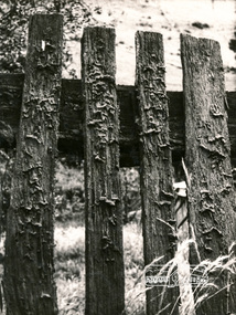
Photograph, George W. Bell, Fence, farmhouse, Yarra Glen Road
Black and white photograph of timber picket fence Yarra Glen Road Kangaroo Groundyarra glen road, kangaroo ground, fences, george w bell collection -
 Eltham District Historical Society Inc
Photograph, Sweeneys Lane looking southwest, Dec 1984, 198412
Two colour photographs of view south across Sweeneys flats and Yarra River, Sweeneys Lane, Elthamsweeneys lane, yarra river, eltham, thomas sweeney, culla hill -
 Eltham District Historical Society Inc
Photograph, Yarra River, Sweeneys flats, 1994c
Colour photogrpah of oblique aerial view looking east over Yarra River and Sweeneys flats c.1994sweeneys lane, yarra river, culla hill, thomas sweeney, aerial photographs -
 Eltham District Historical Society Inc
Folder, Robert Lowman, 1882
... Past and Present Brochure (Yarra Glen District Historical... Past and Present Brochure (Yarra Glen District Historical ...Robert Lowman, Christmas Hills, 1882 Lowman built his Lowman's Hotel or Lowman's Folly on Osborne Road - Yarra Glen Road, Christmas Hills in the 1870s when the main road from Christmas Hills to Yarra Glen (then "Yarra Flats") used to follow the present Eltham -Yarra Glen Road to Osborne Road, then followed that to Mt Wise Road and down the escarpment. Years later a new road was opened leaving Lowmna's Hotel high and dry to gain renown as "Lowman's Folly". It closed in the early 1890s. See Christmas Hills Past and Present Brochure (Yarra Glen District Historical Society), 2004Folderrobert lowman, hotelier, christmas hills -
 Eltham District Historical Society Inc
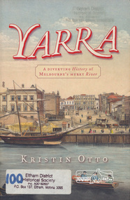
Book, Kristin Otto, Yarra : a diverting history of Melbourne's murky river / Kristin Otto, 2005
"It was John Wedge, Batman's private surveyor, who named the Yarra Yarra. In September 1835 he was at the Turning Basin with some Kulin and heard them identify the river as it came over the Falls as, he wrote, 'Yarrow Yarrow'. It was only some months later that Wedge discovered they had been referring to the pattern and movement of water over the Falls, not the river itself. And ever since, it has been the Yarra's fate to be misunderstood: maligned for its muddiness, ill-used as sewer and tip; scooped, sculpted, straightened and stressed, 'cleaned up' to the detriment of its natural inhabitants; built-over, under and beside; worked mercilessly and then bridged almost to maritime extinction. In Kristin Otto's superbly entertaining new history, the whole sorry tale is laid bare. From the creation stories of Kulin owners and geologist blow-ins (and Robert Hoddle's bad-tempered expedition to the headwaters) to the twenty-first-century waterside building boom, Otto traces the course of Melbourne's murky river. Erudite, affectionate and witty, with more meanders and diversions than the river itself, Yarra is both a fascinating read and a fitting tribute to the 'noble stream'." -- Publisher's website.Paperback; [viii], 245 p. : illus., maps ; 24 cm.ISBN 1920885781yarra river -
 Eltham District Historical Society Inc
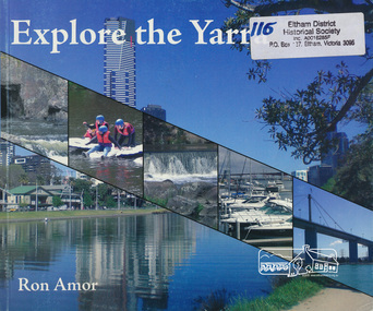
Book, Ron Amor, Explore the Yarra / Ron Amor, 2009
Paperback; 101 p. : ill. ; 21 x 25 cm.ISBN 9780980308525yarra river, yarra river valley -
 Eltham District Historical Society Inc
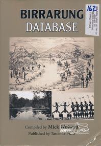
Book, Tarcoola Press, Birrarung Database compiled by Mick Woiwod, 2012
Sister publication to "Coranderrk database". This is a compilation of Mick Woiwod's research material, gathered over many years with information on the history of the Wurundjeri people of the Yarra Valley, from the time of first European contact. The publication runs in excess of 140,000 words. Its prime focus is the Yarra River as it has been understood by its Wurundjeri people. Includes a compilation of those difficult to locate "brief snatches of the action" collated under headings with in each instance, the provenance as to source and / or author included. Themes include: agriculture, law, ceremony, language, reconciliation, retribution, lifestyle, art & craft, climate, personalities, disease, death and the river's flora and fauna.318 pages : illustrations, maps ; 30 cm + 1 CD-ROM (4 3/4 in.) PDF or Microsoft Office Word 97-2003.ISBN 9780987157423wurundjeri, yarra river, indigenous history -
 Eltham District Historical Society Inc
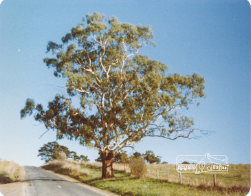
Photograph, Peter Bassett-Smith, White Gum, Main Road Eltham-Yarra Glen, Kangaroo Ground, June 1977, 1977
Colour photograph of a Eucalyptus Viminalis (White Gum or Ribbony Gum or Manna Gum) on Main Road, Eltham-Yarra Glen (Melways Directory Map 23 D1) looking west approximately 1 mile from Kangaroo Ground approx. opposite Andy Avard's gate.eltham yarra glen road, kangaroo ground -
Eltham District Historical Society Inc
Folder, Thomas Armstrong
... by Alexander Sutherland. Chapter 19, "The Upper Yarra District" pages... Sutherland. Chapter 19, "The Upper Yarra District" pages [402] - 415 ...Armstrong, Thomas, J.P. Yarra Flats, was born in Roxburghshire, Scotland, in 1818, and in 1838, being then twenty years of age, emigrated to Australia, and engaged in taking contracts. In 1841, in conjunction with Mr. Wm. Bell he took out a squatting license and settled in what is now known as the township of Eltham. Mr Armstrong purchased land on Kangaroo Ground, where he lived, until 1854, and then bought from Mr. John Dickson, a station on Yarra Flats, containing about 100,000, which at the expiration of two years was sold by public auction. Messrs Armstrong and Bell then bought 14,000 acres where Mr Armstrong, now resides. He has been a member of the local council for twenty-eight years, and holds Her Majesty’s commission of the peace. His wife, Miss Diana Bell (daughter of his partner, Mr. Wm. Bell), whom he married in 1841, died fifteen years ago. from "Victoria and its Metropolis: Past and Present" written in 1888 by Alexander Sutherland. Chapter 19, "The Upper Yarra District" pages [402] - 415. Includes descriptions of some townships and short biographies of local residents. Page 405 Folder of information on Thomas Armstrong, JP, Kangaroo Groundthomas armstrong -
Eltham District Historical Society Inc
Folder, Simon Armstrong, 1868
... . Chapter 19, "The Upper Yarra District" pages [402] - 415. Includes.... Chapter 19, "The Upper Yarra District" pages [402] - 415. Includes ...Simon Armstrong Armstrong, Simon, Kangaroo Ground, is a native of Scotland, born in 1822. In October 1839 he came to Melbourne where he remained for one year, after which he went to Essendon, and stayed there until 1867, when he went to Kangaroo Ground, and established himself as a farmer on partially improved land purchased from Mr Thomas Armstrong; and he also possesses 160 acres at Yarra Flats, which he uses for grazing purposes. Mr Armstrong was married in 1854, and has a family of two sons and five daughters. from "Victoria and its Metropolis: Past and Present" written in 1888 by Alexander Sutherland. Chapter 19, "The Upper Yarra District" pages [402] - 415. Includes descriptions of some townships and short biographies of local residents. Page 405 Folder of information on Simon Armstrong, Kangaroo Ground, 1868simon armstrong -
 Eltham District Historical Society Inc
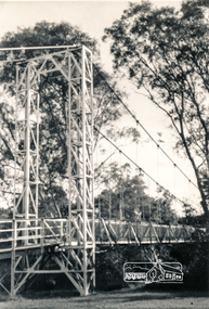
Photograph, Pedestrian suspension bridge over the Yarra River at Lower Plenty
Odyssey House drug rehabilitation centre in Bonds Road, Lower Plenty is a distinctive landmark, especially when viewed from across the Yarra at Templestowe. It was built in the 1950’s as a seminary for the Blessed Sacrament Fathers. Because of the poor and circuitous road access, a suspension footbridge was built across the river. As well as providing easy access for the priests residents of Templestowe could attend services at the seminary. The bridge is now part of the Yarra Trails system.Two black and white photographs of footbridge over Yarra River, part of the Ruffey Trail just off the Main Yarra Trail near the former seminary (now Odyssey House) Lower Plentybridges, yarra river, odyssey house, bonds road, lower plenty, seminary, blessed sacrament fathers -
 Eltham District Historical Society Inc
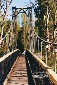
Photograph, Pedestrian suspension bridge over the Yarra River at Lower Plenty
Odyssey House drug rehabilitation centre in Bonds Road, Lower Plenty is a distinctive landmark, especially when viewed from across the Yarra at Templestowe. It was built in the 1950’s as a seminary for the Blessed Sacrament Fathers. Because of the poor and circuitous road access, a suspension footbridge was built across the river. As well as providing easy access for the priests residents of Templestowe could attend services at the seminary. The bridge is now part of the Yarra Trails system.Colour photograph of footbridge over Yarra River, part of the Ruffey Trail just off the Main Yarra Trail near the former seminary (now Odyssey House) Lower Plentybridges, yarra river, lower plenty, seminary, blessed sacrament fathers, odyssey house, bonds road -
 Eltham District Historical Society Inc
Photograph, Watsons Creek Bridge, 1970c
Black and white photograph of Yarra Glen Road Bridge over Watsons Creek at Watsons Creek (Kangaroo Ground) c.1970bridges, watsons creek, kangaroo ground, yarra glen road, eltham yarra glen road -
 Eltham District Historical Society Inc
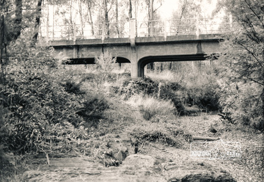
Photograph, Old Warrandyte Bridge
Postcard showing old timber trestle Warrandyte Bridge over Yarra Riverbridges, yarra river, warrandyte, kangaroo ground road -
 Eltham District Historical Society Inc
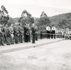
Photograph, Opening Warrandyte Bride, 8 Dec 1955
Built at a cost of £75,000 the five-span reinforced concrete bridge replaced the oldest bridge across the Yarra river, linking the Shire of Doncaster-Templestowe on the south bank with Eltham on the north. The bridge was opened by Mr. G. Reid, M.L.A.Three black and white photographsbridges, warrandyte, yarra river, councillors, ceremonies, stanley addison -
 Eltham District Historical Society Inc
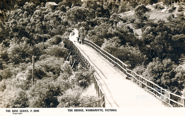
Photograph, The Bridge, Warrandyte, Victoria
Postcard showing old timber bridge over Yarra River at WarrandyteThe Rose Series P.2046bridges, yarra river, warrandyte, kangaroo ground road, postcards -
 Eltham District Historical Society Inc
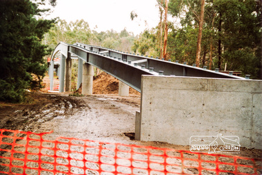
Photograph, Doug Orford, Commencement of bridge works across Yarra River at rear of Eltham Lower Park, May 2004, 2004
Two colour photographs showing commencement of construction of Eltham-Templestowe footbridge over Yarra River off Homestead Road, Eltham which was completed July 2004.bridges, yarra river, eltham, eltham south, templestowe, eltham lower park, lenister farm, homestead road -
 Eltham District Historical Society Inc
Photograph, Doug Orford, Bridge works across Yarra River at rear of Eltham Lower Park, June 2004, 2004
Three colour photographs showing commencement of construction of Eltham-Templestowe footbridge over Yarra River off Homestead Road, Eltham which was completed July 2004.bridges, yarra river, eltham, eltham south, templestowe, eltham lower park, lenister farm, homestead road -
 Eltham District Historical Society Inc
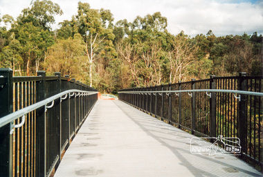
Photograph, Doug Orford, Completion of bridge works across Yarra River at rear of Eltham Lower Park, July 2004, July 2004
Brand new Eltham-Templestowe footbridge over the Yarra River off Homestead Road, Eltham which was completed in July 2004. The Yarra River Footbridge was opened in August 2004 and links the Diamond Creek Trail between the Shire of Nillumbik and City of Manningham. It is a shared pathway and also links with the Main Yarra Trail. It affords lovely views over the Yarra River.One of three colour photographs.yarra river, eltham south, eltham lower park, lenister farm, homestead road, shared pathway, diamond creek trail, footbridge -
 Eltham District Historical Society Inc
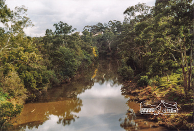
Photograph, Doug Orford, Yarra River from Eltham-Templestowe Footbridge, 2004, 2004
Two colour photographs of Yarra River upstream and downstream from Eltham-Templestowe footbridgeyarra river, bridges, eltham, eltham south, templestowe, eltham lower park, lenister farm -
Emerald Museum & Nobelius Heritage Park
Yarra Valley Mountain and District Football League 1989 to 1992 Match Results & Team Ladders Seniors, Reserves & Under 17, Yarra Valley Mountain District Football League, 1989
... Yarra Valley Mountain and District Football League 1989 to...yarra valley mountain & district football league...Yarra Valley Mountain District Football League... League. yarra valley mountain & district football league emerald ...The reports are primarily historically & socially significant for understanding the local football community, they also give some insight into the local families who were regularly involved in the Football League.black plastic 4 ring binder labelled "Results & League Ladders 1989 - 1992"has been re-labeled, cover slightly wornyarra valley mountain & district football league, emerald football club, match results, league ladder, seniors, reserves, under 17 -
Emerald Museum & Nobelius Heritage Park
Yarra Valley Mountain and District Football League 1981 to 1984 Match Reports Emerald Football Club, circa 1981
... Yarra Valley Mountain and District Football League 1981 to...yarra valley mountain & district football league... Emerald yarra-valley-and-the-dandenong-ranges The reports ...The reports are primarily historically and socially significant for understanding the local football community especially as it names many members of the team. they also give some insight into the local families regularly involved in the Emerald Football Clubblack plastic 4 ring binderlabeled "Red & Black Game reviews 1981 - 1984yarra valley mountain & district football league, emerald football club, match reports, seniors, reserves, under 17 -
Emerald Museum & Nobelius Heritage Park
Yarra Valley Mountain and District Football League Results1623 to 1946, Fixtures and Ladders
... Yarra Valley Mountain and District Football League...yarra valley mountain district football league... seniors reserves under 17 yarra valley mountain district football ...The reports are primarily historically and socially significant for understanding the local football community . Also gives some insight into the local families who were regularly involved with the Emerald Football Club.black plastic 4 ring binderlabeled "FTG News Results 1923 - 1925, 1936, 1838 - 1941, 1945 - 1946 Fixtures 1937 - 1974 YVMDFL Results and Ladders" been re-labeledemerald, football, match reports, fixtures, ladders, seniors, reserves, under 17, yarra valley mountain district football league