Showing 5851 items
matching farm
-
 Kiewa Valley Historical Society
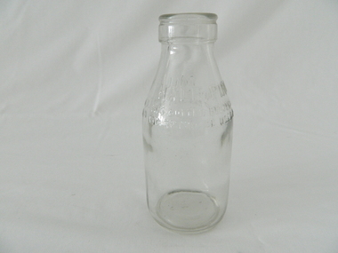
Bottle Milk, mid to late 1900's
This glass milk bottle was manufactured and used mid to late 1900's (1834 Victorian dairy industry was founded) up until the time that a cheaper container was invented(plastic bottles and polyethylene plastic lined cardboard cartons). In 1909 the supply of pure bottled milk was required for babies to overcome infant mortality due to unhygienic milk sources (unclean containers and unpasteurized milk). Due to the volume of milk being processed and hand milking could not keep up with demand, dairy farms introduced milking machines in the late 1930's. The great increases in dairy herds from the average of 18 cows per heard in 1950's to 142 cows per herd in 1996 required milk tankers to pick up the regions milk supply. This bottle was so constructed to be easily moved within the milk processing plants from the delivery vats/holding tanks to the final corking/sealing of the bottles for eventual distribution. From 1958 the milk bottle slowly became phased out of production. At this point in time Melbourne was drawing 160,000 bottles per week from the two major glass bottle works companies, e.g. Melbourne Glass Bottle Works Co.Victoria was the major state supplier of cows milk in the history of Australian milk production from the early 1800's. The Kiewa Valley and its region was a major contributor to meet that demand. Each bottle was "branded" during manufacturing to show the contents (pasteurized milk) and where it originated from (region and supplier). This method of recycling the bottles back to specific dairy farms was a good control method but an uneconomical "on cost" which was replaced by the "throw away" less costly plastic and cardboard containers. Kiewa Valley dairy herds had marked bottles bearing "90/9", "6/18", "6/33", "6/35" and "6/36" Found under the house at 1 Beauty Ave., Mt BeautyThis heavy gauged glass milk bottle has a rim and a distinctive head at the top. This head has been manufactured to facilitate the movement of the bottle along the milk production line. The method of pouring milk into the bottle has been part of the "production line". This bottle has a half pint capacity and is made from "clear" glass. There are other milk bottles that have a "green" tint in them and this tint was to protect the contents from sun damage. This thick glass bottle to contain milk required its thickness because of the extensive handling before final consumption. Milk was delivered by the "milk man" direct to the homes of consumers. During this period delivery to homes in cities and towns was made initially by horse and cart and later by truck.On the top half of this bottle is "MILK" and opposite "HALF PINT". Below this "THIS BOTTLE BELONGS TO MILK BOTTLE RECOVERY LTD" and below this "AND CANNOT BE USED WITHOUT WRITTEN PERMISSION" on the base is "2 M" underneath this "8/11" and underneath is "ISM -169"glass bottles, commercial milk containers, domestic milk bottles, pasteurized milk bottles -
 Kiewa Valley Historical Society
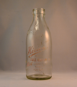
Bottle Milk, Circa mid to late 1900's
This glass milk bottle was manufactured and used mid to late 1900's (1834 Victorian dairy industry was founded) up to the time that a cheaper container was invented(plastic bottles and polyethylene plastic lined cardboard cartons) and produced. In 1909 the supply of pure bottled milk was required for babies to overcome infant mortality due to unhygienic milk sources (unclean containers and unpasteurized milk). Due to the volume of milk being processed and hand milking could not keep up with demand, dairy farms introduced milking machines in the late 1930's. The great increases in dairy herds from the average of 18 cows per heard in 1950's to 142 cows per herd in 1996 required milk tankers to pick up the regions milk supply. This bottle was so constructed to be easily moved within the milk processing plants from the delivery vats/holding tanks to the final corking/sealing of the bottles for eventual distribution. From 1958 the milk bottle slowly became phased out of production. At this point in time Melbourne was drawing 160,000 bottles per week from the two major glass bottle works companies, e.g. Melbourne Glass Bottle Works Co. Victoria was the major state supplier of cows milk in the history of Australian milk production from the early 1800's. The Kiewa Valley and its region was a major contributor to meet that demand. Each bottle was "branded" during manufacturing to show the contents (pasteurized milk) and where it originated from (region and supplier). This method of recycling the bottles back to specific dairy farms was a good control method but an uneconomical "on cost" which was replaced by the "throw away" less costly plastic and cardboard containers. Kiewa Valley dairy herds had marked bottles bearing "90/9", "6/18", "6/33", "6/35" and "6/36" This particular one has "7/14".This heavy gauged glass milk bottle has a rim and a distinctive head at the top. This head has been manufactured to facilitate the movement of the bottled along the milk production line. The method of pouring milk into the bottle has been part of the "production line". This bottle has a one Imperial pint capacity and is made from "clear" glass. There are other milk bottles that have a "green" tint in them. Around the bottom side of the bottle and blown into the glass "ONE IMPERIAL PINT". Below these markings and stenciled is "KIEWA" (in freehand style and underlined) underneath is "PASTEURISED FULL CREAM MILK" underneath this ,in freehand stiyle is "USE" next to this in block style "KIEWA BUTTER, CREAM, AND ICE CREAM MIX" to the left of this ,and barely readable is stenciled "THIS BOTTLE ALWAYS REMAINS/ THE PROPERTY OF/ NORTH EASTERN DAIRY Co. Ltd". On the base of the bottle is molded a big "2". with a smaller "m". An identification mark of "7" over "14" is within a circled boundary. Below this is moulded "RM - 15". glass bottles, commercial milk containers, domestic milk bottles, pasteurized milk bottles -
 Eltham District Historical Society Inc
Photograph, Liz Pidgeon, Heritage Excursion; Eltham Lower Park Walk and Talk, 1 July 2017, 1 July 2017
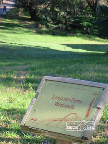
Information Board - Lenister Farm Wetlands Newsletter No., 234, June 2017 Heritage Excursion - Saturday 1st July - Eltham Lower Park - Walk and Talk Eltham Lower Park has played an important part in the history of our area since the early days of European settlement when it was used by local residents as an informal racecourse. Prior to that its location at the junction of the Diamond Creek and the Yarra River made it an important meeting place for the Wurundjeri people. The park combines formal elements and sporting facilities with remnant bushland that is of environmental significance. It is home to sporting and horse riding clubs, popular play spaces and the Diamond Valley Miniature Railway, which attracts large numbers of visitors. The park will be the venue for our July excursion which will comprise a walk of about 3.5 km around the park and adjacent areas. Along the way we will discuss the history and natural history of the area. The path along the creek and the river provides a pleasant and scenic walk. This walk on Saturday 1st July is about 3.5 km in length and will take 2 to 2.5 hours. It will start at 2pm at the Main Road car park at the front of the park. (Melway ref 21 H 10). Born Digitalheritage excursion, activities, eltham district historical society, eltham lower park, information board, lenister farm -
 Eltham District Historical Society Inc
Photograph, Liz Pidgeon, Heritage Excursion; Eltham Lower Park Walk and Talk, 1 July 2017, 1 July 2017
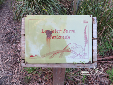
Information Board with rust - Lenister Farm Wetlands Newsletter No., 234, June 2017 Heritage Excursion - Saturday 1st July - Eltham Lower Park - Walk and Talk Eltham Lower Park has played an important part in the history of our area since the early days of European settlement when it was used by local residents as an informal racecourse. Prior to that its location at the junction of the Diamond Creek and the Yarra River made it an important meeting place for the Wurundjeri people. The park combines formal elements and sporting facilities with remnant bushland that is of environmental significance. It is home to sporting and horse riding clubs, popular play spaces and the Diamond Valley Miniature Railway, which attracts large numbers of visitors. The park will be the venue for our July excursion which will comprise a walk of about 3.5 km around the park and adjacent areas. Along the way we will discuss the history and natural history of the area. The path along the creek and the river provides a pleasant and scenic walk. This walk on Saturday 1st July is about 3.5 km in length and will take 2 to 2.5 hours. It will start at 2pm at the Main Road car park at the front of the park. (Melway ref 21 H 10). Born Digitalelection day, heritage excursion, activities, eltham district historical society, eltham lower park, information board, lenister farm wetlands -
 Eltham District Historical Society Inc
Photograph, Liz Pidgeon, Heritage Excursion; The 1901 Eltham Railway Walk, 3 May 2014, 3 May 2014
Newsletter No. 216, May 2014 May Excursion – The 1901 Eltham Railway Walk The railway from Heidelberg to Eltham was opened in 1902. Over the previous year railway construction cut a curving swathe through Josiah Holloway’s 1851 Little Eltham subdivision. The survey plans for the railway show the owners and occupiers of land within Little Eltham affected by the railway alignment and for some distance each side. The plans show houses and other buildings but development at that time was rather sparse. Copies of these plans from the State Library of Victoria collection have been provided to the Society by Alan Sheehan. For our walk on 3rd May we intend to follow the railway from the Eltham Station to Ryans Road, which was the boundary of the adjoining Montmorency Farm. The return will be by way of nearby streets. Along the way we will discuss the details shown on the railway plans as well as more recent railway documents and photographs. At the conclusion and if time permits we can inspect the historical display at the Eltham Station. The walk is about 3 km in length and will take about 2.5 hours. It will start at 2 pm at the Eltham Railway Station car park (east/Main Road side) (Melway Ref. 21 J5).Born Digitalheritage excursion, activities, eltham district historical society, eltham railway station, eltham library, trestle bridge -
 City of Moorabbin Historical Society (Operating the Box Cottage Museum)
Photograph, Black & White Horse drawn scoops earthwork in Moorabbin Shire c1900, c1900
The, horse drawn metal scoop ,guided by a man, was used to clear earth for road making. Well before the introduction of motorised, mechanical graders and trucks the painstaking, labour-intensive work was undertaken by large teams of sturdy men using strong horses such as the draught horse. Roads were needed by the market gardeners to transport their produce to market. Later as the heavy wagon loads continually caused ruts and general degradation of the roadways a Plateway system was installed so that the wagon wheels could roll along the rails thus protecting the roadways. August 31st 2021 Ron Nash, from WA, informs us "The men and horses pulling earth scoops in the photo are not moving earth for road making - they are excavating an "earth tank", or dam, as described in common nomenclature today. This skill was known as "tank sinking", and tank sinkers were active in many rural and remote areas in the 1800's and early 1900's, establishing sizeable dams for important water reserves for community and farm and railway use. With the advent of mechanised equipment such as bulldozers, the trade of tank sinking was still carried out, but on a faster basis. I am a former tank sinker and earth moving contractor, now long retired." Early settlers in Moorabbin Shire had to build the roads, plateways, drains, as the settlement of the land, in Dendy's Special Survey 1841 Brighton, spread and market gardeners need to transport their produce to market. Their most valuable possession was the draught horse that was used for ploughing, drawing carts and these scoops.Black & White photograph showing many horses pulling metal scoops guided by men to move earth for road making in Moorabbin Shire c 1900Back Handwritten Informationplateway, roadworks moorabbin shire, draught horses, metal scoops, paviers, box alonzo, smith j l; chaff cutter, horse drawn carts, toll gates brighton, motor cars 1900, steam engines, early settlers, bentleigh, mckinnon, parish of moorabbin, city of moorabbin, county of bourke, moorabbin roads board, shire of moorabbin, henry dendy's special survey 1841, were j.b.; bent thomas, o'shannassy john, king richard, charman stephen, highett william, ormond francis, maynard dennis, market gardeners, vineyards, orchards -
 Flagstaff Hill Maritime Museum and Village
Clothing - Leather Leggings, 1899 to 1920
The subject leather leggings are associated with mounted troops known as the Australian Light Horse that served in the South African War from 1899 to 1902. After the war, Britain wanted to use fewer mounted troops and restructured its force around a style of combat that needed more infantry. But the defence of Australia still relied upon mounted military units as these were more mobile than infantry and could travel faster over long distances. Light Horse brigades in the Australian Imperial Force (AIF) mostly contained recruits who served in the Light Horse regiments of the Citizen Forces. Many young men from rural areas of Australia volunteered for the Light Horse regiments. They had to pass a riding test to join, this test was easier for men from the bush because horses were still the main method of transport on farms and in country towns. The army did not officially accept First Australians into the AIF until May 1917 when enlistment standards were relaxed to include 'half-castes' with a parent of European origin. Indigenous soldiers served as valuable members of the Light Horse and many possessed excellent horse handling skills and specialist tracking knowledge.The subject items are part of the uniform for the Light Horse Units that served in the Australian army from 1899 until 1918. These leggings were worn by soldiers on horseback and are significant as they represent a noteworthy time in Australia's early military history. It was a time when many young men gave their lives during the South African and First World Wars in the defence of the then British Empire as part of the Imperial Forces that were gathered from many British-controlled Colonial countries.A pair of two Leather Leggings used by Mounted Australian soldiers during the first world war. The leggings are dark tan in colour with stitching to attach buckles and fastener straps. The strap buckles are made of brass and the leather legging straps are of same leather as leggings. Noneflagstaff hill, warrnambool, flagstaff hill maritime museum, shipwreck coast, flagstaff hill maritime village, great ocean road, leggings, leather leggings, protective leggings, protective clothing, australian mounted light horse units, military equipment -
 Mount Evelyn History Group
Photo (framed) L Morrison, Seated portrait of Mrs Louisa Morrison nee Haag (?), c. 1940
This item was donated as a photograph of Louisa Morrison. Louisa (or Luisa) Rosanna Morrison nee Haag came from an early settler family in the farming community of Wandin. The woman photographed is in her old age. If this is indeed Louisa Morrison, the photograph would date from the early 1940s, since she died in 1946 at the age of 70. However the costume and the style of the photo suggest an earlier date, possibly the early 1900s. This could be Louisa's mother, Emma Martha Haynes, or mother-in-law Margaret (McNeil) Morrison. The woman is shown in a garden, probably because the family were farmers/orchardists. Louisa married Daniel McNeil Morrison, who was nine years her senior , in 1900. They had four children and farmed Morrisons' Orchard in Old Hereford Road, Mt Evelyn. The Morrison home was to become the important community house in Mt Evelyn, Morrison House. Morrison Reserve is part of their land, as was Yarra Hills Secondary College, Mt Evelyn Special Developmental School and the Reserve and Athletics facilities, including a tennis club. In 1981 the land title was changed to the Shire of Lillydale, who purchased the land and established the Morrison House Community House from 1976 (ie before they legally owned the land).This picture is of social significance as it is the only reputed picture of Louisa Morrison nee Haag.Brown round cornered frame with gold colour on inner frame. Painted plaster on frame chipped on top right. Coloured (painted) photograph of seated woman in upholstered chair with large brown cushion behind her. Garden setting. Black floor length dress, high necked, long sleeved. White cap on head. White cloth showing at neck.Bottom right hand corner, signature "F. RAPHAEL". Reverse: four inscriptions, one on each straight side, stamped in ink. Top: "MADE IN / AUSTRALIA". Right side: "THIS MOUNTING IS SPECIALLY DESIGNED AND / SELECTED WORKMANSHIP AND MATERIALS / GUARANTEED". Bottom: Table, 1 row, 2 columns. 1st cell: "STYLE / 1". 2ND CELL: "PRICE / 3 GNS". Left: box with 2 columns, 1 row. Left most column is divided horizontally into two, as is the 2nd column, but at a lower level. This creates four cells. Top left: "STYLE 1". Bottom left "PRICE 2 GNS". Top right: "TO BE SOLD AT PRICE MARKED OPPOSITE ONLY ON CONDITION THAT SAME IS MOUNTED ON ONE OF OUR SAMPLE STUDIES". Bottom left: "EMPIRE ART COMPANY LIMITED".louisa, morrison, haag, morrison house, farming, orchard, mt evelyn, photograph, wandin -
 Bendigo Historical Society Inc.
Document - Jonathan Harris / Axedale
Jonathan Harris was born in Sussex England in 1822. His father Jonathan Snr was transported to Australia and his wife obtained permission to follow him as a free settler when Jonathan jnr was about 7 yrs.In 1842, Jonathan snr (who held a ticket of leave) and his son Jonathan Jnr were found guilty of theft and transported to Tasmania. Family history suggests that following his term, Jonathan jnr became a police detective before returning to Victoria. He and his wife had a store at Third White Hill in Bendigo and one day while walking to Eaglehawk, Jonathan found a rich vein of gold in what was to become the Hustlers Mine. He took large samples to England for crushing and subsequently sold his claim. Upon returning to Melbourne he conducted a business before taking up land at Axedale. He farmed here, including the growing of apples up until his death 20/7/1881. His efforts must have been successful as following his death the sale of property at Axedale included two pieces of land that each had two cottages that had been rented out. Jonathan was also on the board of the Axedale School.An 8 page document detailing the life of Axedale man Jonathan Harris.view street, house, goldfield -
 Surrey Hills Historical Society Collection
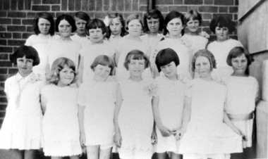
Photograph, Chatham State School Grade 2 1928, 1931
Chatham School, located in Weybridge Street Surrey Hills, was opened on 1 August 1927 following pressure from local residents as nearby schools (Balwyn, Mont Albert & Surrey Hills) were all over-crowded. This followed a surge in development following WW1. Land in surrounding streets was sub-divided. This included part of John Butler Maling (Jnr)'s small farm bounded by Banool Road, Wharton Road, Weybridge Street and Whitehorse Road. An area surrounding his home, 'The Willows' was retained and not sold until after he died in 1931. leased by Mr John Butler Maling in 1861. Three acres of his land were purchased by the Education Department. Some of the early students have referred to Chatham’s land as Mr Maling’s bull paddock. Some of the original yellow box trees remain on the property. The most significant of these is now called the Friendship Tree. On 1 August 1927 212 students were enrolled; Ralph Rae was one of these. The school was official opened on 15th February 1928. The school number is 4314. Front row centre is Jocelyn Cerini who married Ken Hall, another Chatham student. A black and white photograph of a group of Grade 2 female students from Chatham State School. They are dressed in white.schools, chatham state school, clothing and dress, primary schools, john butler maling (jnr), ralph rae (mr), jocelyn cerini (miss), jocelyn hall (mrs) -
 National Wool Museum
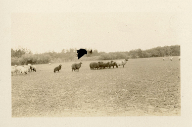
Photograph - Karakul Sheep, J W Allen, 1928-1929
This photograph was found loose in the second of three albums compiled and owned by J W Allen, Secretary of New South Wales Grazier's, and is associated with the New South Wales Graziers Association world tour of sheep 1928-1929. The album contains photographs of travel, sheep, farms, stations, people and landscapes from around the world. Locations include Kenya, Kinangop, Naivasha, Elementeita, Lake Nakuru, Njoro, Namibia, Otjihavera, Mt Kenya, Isiolo, Yemen, Aden, Suez, River Jordan, Jerusalem, Hebron, Bethlehem, Beersheba, Galilee, Lake Tiberias, Mt Hermon, Canada, Mt Robson, Fraser River Canyon, British Columbia, Merrit, Canford, Alberta, Cardston, Pekisko Creek, Turner Valley, Calgary, Saskatoon, Manitoba, Winnipeg, Portage la Prairie, Niagara Falls, Quebec, Sainte-Anne-de-la-Pocatière and St Lawrence River. Properties depicted include Kenton Estates, Kekopey Ranch, Soysambu Ranch, Larmudiac, SX Ranch, Neilson's Ranch, EP Ranch and CX Ranch. The album was found in a clean out at the Great Southern Agricultural Research Institute and donated to the National Wool Museum, along with other related material such as photographs, glass lantern slides and ephemera.Black and white image showing sheep in a paddock.world tour, sheep, graziers, photograph, karakul, winnipeg, canada, manitoba, agriculture -
 National Wool Museum
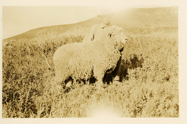
Photograph - 'Harvey' Ram at Neilson's Ranch, J W Allen, 1928-1929
This photograph was found loose in the second of three albums compiled and owned by J W Allen, Secretary of New South Wales Grazier's, and is associated with the New South Wales Graziers Association world tour of sheep 1928-1929. The album contains photographs of travel, sheep, farms, stations, people and landscapes from around the world. Locations include Kenya, Kinangop, Naivasha, Elementeita, Lake Nakuru, Njoro, Namibia, Otjihavera, Mt Kenya, Isiolo, Yemen, Aden, Suez, River Jordan, Jerusalem, Hebron, Bethlehem, Beersheba, Galilee, Lake Tiberias, Mt Hermon, Canada, Mt Robson, Fraser River Canyon, British Columbia, Merrit, Canford, Alberta, Cardston, Pekisko Creek, Turner Valley, Calgary, Saskatoon, Manitoba, Winnipeg, Portage la Prairie, Niagara Falls, Quebec, Sainte-Anne-de-la-Pocatière and St Lawrence River. Properties depicted include Kenton Estates, Kekopey Ranch, Soysambu Ranch, Larmudiac, SX Ranch, Neilson's Ranch, EP Ranch and CX Ranch. The album was found in a clean out at the Great Southern Agricultural Research Institute and donated to the National Wool Museum, along with other related material such as photographs, glass lantern slides and ephemera.Black and white image showing a man and a sheep in the foreground with mountains in the background.Back: [handwritten] Harvey ram / at Neilson’s / Harvey / Neilson’s ranch [printed] A 40world tour, sheep, graziers, photograph, canada, agriculture, cardtson, alberta