Showing 485 items
matching first survey
-
 Kew Historical Society Inc
Plan, Melbourne & Metropolitan Board of Works : Borough of Kew : Detail Plan No.1578, 1904
The Melbourne and Metropolitan Board of Works (MMBW) plans were produced from the 1890s to the 1950s. They were crucial to the design and development of Melbourne's sewerage and drainage system. The plans, at a scale of 40 feet to 1 inch (1:480), provide a detailed historical record of Melbourne streetscapes and environmental features. Each plan covers one or two street blocks (roughly six streets), showing details of buildings, including garden layouts and ownership boundaries, and features such as laneways, drains, bridges, parks, municipal boundaries and other prominent landmarks as they existed at the time each plan was produced. (Source: State Library of Victoria). This plan forms part of a large group of MMBW plans and maps that was donated to the Society by the Mr Poulter, City Engineer of the City of Kew in 1989. Within this collection, thirty-five hand-coloured plans, backed with linen, are of statewide significance as they include annotations that provide details of construction materials used in buildings in the first decade of the 20th century as well as additional information about land ownership and usage. The copies in the Public Record Office Victoria and the State Library of Victoria are monochrome versions which do not denote building materials so that the maps in this collection are invaluable and unique tools for researchers and heritage consultants. A number of the plans are not held in the collection of the State Library of Victoria so they have the additional attribute of rarity.Original survey plan, issued by the MMBW to a contractor with responsibility for constructing sewers in the area identified on the plan within the Borough of Kew. The plan was at some stage hand-coloured, possibly by the contractor, but more likely by officers working in the Engineering Department of the Borough and later Town, then City of Kew. The hand-coloured sections of buildings on the plan were used to denote masonry or brick constructions (pink), weatherboard constructions (yellow), and public buildings (grey). MMBW Plan No.1578 is significant in that it defines the extent of two private schools: Xavier College and Kew High School (now part of Trinity Grammar) by 1904. In relation to the latter, the plan clarifies which buildings the High School operated from behind the mansion ‘Molina’. Established in 1902, Trinity Grammar was to later lease and subsequently buy Molina (now ‘Merritt House’) and ‘Elsinore’ (now ‘Roberts House’). Xavier College had been established in 1872. This 1904 plan delineates the West Wing and the Great Hall (built in 1890).melbourne and metropolitan board of works, detail plans, maps - borough of kew, mmbw 1578, cartography -
 Kew Historical Society Inc
Plan, Melbourne & Metropolitan Board of Works. Borough of Kew Detail Plan No.1579, 1904
The Melbourne and Metropolitan Board of Works (MMBW) plans were produced from the 1890s to the 1950s. They were crucial to the design and development of Melbourne's sewerage and drainage system. The plans, at a scale of 40 feet to 1 inch (1:480), provide a detailed historical record of Melbourne streetscapes and environmental features. Each plan covers one or two street blocks (roughly six streets), showing details of buildings, including garden layouts and ownership boundaries, and features such as laneways, drains, bridges, parks, municipal boundaries and other prominent landmarks as they existed at the time each plan was produced. (Source: State Library of Victoria). This plan forms part of a large group of MMBW plans and maps that was donated to the Society by the Mr Poulter, City Engineer of the City of Kew in 1989. Within this collection, thirty-five hand-coloured plans, backed with linen, are of statewide significance as they include annotations that provide details of construction materials used in buildings in the first decade of the 20th century as well as additional information about land ownership and usage. The copies in the Public Record Office Victoria and the State Library of Victoria are monochrome versions which do not denote building materials so that the maps in this collection are invaluable and unique tools for researchers and heritage consultants. A number of the plans are not held in the collection of the State Library of Victoria so they have the additional attribute of rarity.Original survey plan, issued by the MMBW to a contractor with responsibility for constructing sewers in the area identified on the plan within the Borough of Kew. The plan was at some stage hand-coloured, possibly by the contractor, but more likely by officers working in the Engineering Department of the Borough and later Town, then City of Kew. The hand-coloured sections of buildings on the plan were used to denote masonry or brick constructions (pink), weatherboard constructions (yellow), and public buildings (grey). While MMBW Plan No.1579 does not include many buildings, those that it does show are significant to Kew’s history. These include the ‘Kew [Railway] Station’ in Denmark Street and the ‘Recreation Hall’ and rear courts off Wellington Street. The plan shows the outline of the Recreation Hall, constructed in 1880, at the rear of which is listed a bowling green, two tennis courts, a ‘skittle alley’ and a pavilion. When the Hall was first built, the Kew Cricket Club occupied an adjacent ground, however in 1885 this was acquired by the State Government as the future location of the Kew Railway Station. The Plan also shows a single oval at Xavier College. This oval was completed in 1883. One of the current ovals conforms to this oval’s original shape and position in the school grounds.melbourne and metropolitan board of works, detail plans, maps - borough of kew, mmbw 1579, cartography -
 Kew Historical Society Inc
Plan, Melbourne and Metropolitan Board of Works, Borough of Kew : Detail Plan No.1580, 1904
The Melbourne and Metropolitan Board of Works (MMBW) plans were produced from the 1890s to the 1950s. They were crucial to the design and development of Melbourne's sewerage and drainage system. The plans, at a scale of 40 feet to 1 inch (1:480), provide a detailed historical record of Melbourne streetscapes and environmental features. Each plan covers one or two street blocks (roughly six streets), showing details of buildings, including garden layouts and ownership boundaries, and features such as laneways, drains, bridges, parks, municipal boundaries and other prominent landmarks as they existed at the time each plan was produced. (Source: State Library of Victoria)This plan forms part of a large group of MMBW plans and maps that was donated to the Society by the Mr Poulter, City Engineer of the City of Kew in 1989. Within this collection, thirty-five hand-coloured plans, backed with linen, are of statewide significance as they include annotations that provide details of construction materials used in buildings in the first decade of the 20th century as well as additional information about land ownership and usage. The copies in the Public Record Office Victoria and the State Library of Victoria are monochrome versions which do not denote building materials so that the maps in this collection are invaluable and unique tools for researchers and heritage consultants. A number of the plans are not held in the collection of the State Library of Victoria so they have the additional attribute of rarity.Original survey plan, issued by the MMBW to a contractor with responsibility for constructing sewers in the area identified on the plan within the Borough of Kew. The plan was at some stage hand-coloured, possibly by the contractor, but more likely by officers working in the Engineering Department of the Borough and later Town, then City of Kew. The hand-coloured sections of buildings on the plan were used to denote masonry or brick constructions (pink), weatherboard constructions (yellow), and public buildings (grey). The area represented in this detail plan has undergone significant change during the 20th century. The widening of High Street in the 1930s and 1950s involved the shops on the south side of High Street being demolished and later rebuilt to fit the widened street. Another significant loss was the mansion ‘Drayton’ fronting Wellington Street, owned at this stage by Susannah Fenton. Her family name would later to be given to Fenton Way, which was to be built over the grounds of the house following its demolition. The plan of the garden is particularly interesting, containing a batten dome fronting Wellington Street, an ornamental pond, a fountain and a brick and glass conservatory. The notes by the plumbing contractor on this plan are particularly detailed. Pink borders delineate the ownership of the varying parcels of land. Some of the better known owners listed include the real estate agent Cr. Henry de Castres Kellett (bt) and John Padbury, the funeral director. This particular plan provides a clear view of the configuration of the Kew Junction in 1903 and the commercial buildings that surrounded it.melbourne and metropolitan board of works, detail plans, maps - borough of kew, mmbw 1580, cartography -
 Kew Historical Society Inc
Plan, Melbourne & Metropolitan Board of Works : Borough of Kew : Detail Plan No.1581, 1904
The Melbourne and Metropolitan Board of Works (MMBW) plans were produced from the 1890s to the 1950s. They were crucial to the design and development of Melbourne's sewerage and drainage system. The plans, at a scale of 40 feet to 1 inch (1:480), provide a detailed historical record of Melbourne streetscapes and environmental features. Each plan covers one or two street blocks (roughly six streets), showing details of buildings, including garden layouts and ownership boundaries, and features such as laneways, drains, bridges, parks, municipal boundaries and other prominent landmarks as they existed at the time each plan was produced. (Source: State Library of Victoria)This plan forms part of a large group of MMBW plans and maps that was donated to the Society by the Mr Poulter, City Engineer of the City of Kew in 1989. Within this collection, thirty-five hand-coloured plans, backed with linen, are of statewide significance as they include annotations that provide details of construction materials used in buildings in the first decade of the 20th century as well as additional information about land ownership and usage. The copies in the Public Record Office Victoria and the State Library of Victoria are monochrome versions which do not denote building materials so that the maps in this collection are invaluable and unique tools for researchers and heritage consultants. A number of the plans are not held in the collection of the State Library of Victoria so they have the additional attribute of rarity.Original survey plan, issued by the MMBW to a contractor with responsibility for constructing sewers in the area identified on the plan within the Borough of Kew. The plan was at some stage hand-coloured, possibly by the contractor, but more likely by officers working in the Engineering Department of the Borough and later Town, then City of Kew. The hand-coloured sections of buildings on the plan were used to denote masonry or brick constructions (pink), weatherboard constructions (yellow), and public buildings (grey). The streets and built structures in this plan were surveyed in 1903 and released to contractors in 1904. In addition to the designation of building types by colour, the plan includes detailed descriptions of land use and ownership. While many buildings remain from this period, a number of the buildings represented have been demolished including the original Kew Town Hall, and the Congregational and Roman Catholic churches in Walpole Street. While the mansion ‘Illapa’ in Princess Street is still extant – now part of ‘Rylands’ – the neighbouring mansion ‘Elsmere’ was demolished some decades ago. Rivalling Illapa and Elsmere in size were two mansions in Walpole Street, one named on the plan as ‘Gnarlbine’. Over time, Kew Junction and the south side of High Street have been reconfigured and widened, so that the commercial buildings on the corner of Princess and High Street no longer exist. A surprising feature of this part of central Kew to the northwest of Kew Junction is the amount of vacant land. In a number of cases, this land is noted by the contractor as used for vegetable gardens.melbourne and metropolitan board of works, detail plans, maps - borough of kew, mmbw 1581, cartography -
 Kew Historical Society Inc
Plan, Melbourne & Metropolitan Board of Works : Borough of Kew : Detail Plan No.1582, 1904
The Melbourne and Metropolitan Board of Works (MMBW) plans were produced from the 1890s to the 1950s. They were crucial to the design and development of Melbourne's sewerage and drainage system. The plans, at a scale of 40 feet to 1 inch (1:480), provide a detailed historical record of Melbourne streetscapes and environmental features. Each plan covers one or two street blocks (roughly six streets), showing details of buildings, including garden layouts and ownership boundaries, and features such as laneways, drains, bridges, parks, municipal boundaries and other prominent landmarks as they existed at the time each plan was produced. (Source: State Library of Victoria)This plan forms part of a large group of MMBW plans and maps that was donated to the Society by the Mr Poulter, City Engineer of the City of Kew in 1989. Within this collection, thirty-five hand-coloured plans, backed with linen, are of statewide significance as they include annotations that provide details of construction materials used in buildings in the first decade of the 20th century as well as additional information about land ownership and usage. The copies in the Public Record Office Victoria and the State Library of Victoria are monochrome versions which do not denote building materials so that the maps in this collection are invaluable and unique tools for researchers and heritage consultants. A number of the plans are not held in the collection of the State Library of Victoria so they have the additional attribute of rarity.Original survey plan, issued by the MMBW to a contractor with responsibility for constructing sewers in the area identified on the plan within the Borough of Kew. The plan was at some stage hand-coloured, possibly by the contractor, but more likely by officers working in the Engineering Department of the Borough and later Town, then City of Kew. The hand-coloured sections of buildings on the plan were used to denote masonry or brick constructions (pink), weatherboard constructions (yellow), and public buildings (grey). Public buildings, coloured grey on the Plan 1582 include the police station and post office, churches and schools. The earliest church school, Common School No.356 was located at the rear of the Congregational Church in Peel Street. It was constructed in 1859. The first buildings of Kew Primary School No.1075 on the other side of Peel Street were constructed in 1871. The school in 1903 only occupied a small fraction of its current site. In 1903, where the rear playground is now located, were two weatherboard and one brick villa. Trinity Grammar School was founded in 1902 and opened in the Parish Hall at the rear of Holy Trinity Anglican Church. It was not to move to its current site until 1906. The outline of the building housing the Kew Fire Brigade in the centre of the north side of Walton Street is shown but not named on the plan. Further down Pakington Street stood the two-storey Italianate mansion ‘Overton’. The home of Stanford Chapman, it was to be featured in the Imperial Institute series of bromide photographs of Victoria, Vol. 1: Homes and scenery. It was later to become a boarding house before it was later demolished.melbourne and metropolitan board of works, detail plans, maps - borough of kew, mmbw 1582, cartography -
 Kew Historical Society Inc
Plan, Melbourne & Metropolitan Board of Works : Borough of Kew : Detail Plan No.1585, 1904
The Melbourne and Metropolitan Board of Works (MMBW) plans were produced from the 1890s to the 1950s. They were crucial to the design and development of Melbourne's sewerage and drainage system. The plans, at a scale of 40 feet to 1 inch (1:480), provide a detailed historical record of Melbourne streetscapes and environmental features. Each plan covers one or two street blocks (roughly six streets), showing details of buildings, including garden layouts and ownership boundaries, and features such as laneways, drains, bridges, parks, municipal boundaries and other prominent landmarks as they existed at the time each plan was produced. (Source: State Library of Victoria)This plan forms part of a large group of MMBW plans and maps that was donated to the Society by the Mr Poulter, City Engineer of the City of Kew in 1989. Within this collection, thirty-five hand-coloured plans, backed with linen, are of statewide significance as they include annotations that provide details of construction materials used in buildings in the first decade of the 20th century as well as additional information about land ownership and usage. The copies in the Public Record Office Victoria and the State Library of Victoria are monochrome versions which do not denote building materials so that the maps in this collection are invaluable and unique tools for researchers and heritage consultants. A number of the plans are not held in the collection of the State Library of Victoria so they have the additional attribute of rarity.Original survey plan, issued by the MMBW to a contractor with responsibility for constructing sewers in the area identified on the plan within the Borough of Kew. The plan was at some stage hand-coloured, possibly by the contractor, but more likely by officers working in the Engineering Department of the Borough and later Town, then City of Kew. The hand-coloured sections of buildings on the plan were used to denote masonry or brick constructions (pink), weatherboard constructions (yellow), and public buildings (grey). This plan, which covers parts of High Street, Pakington Street and Derby Street is dominated by two historic Kew mansions: ‘Konetta’ and ‘Ramornie’. Ramornie was constructed in 1890 for James Maitland Campbell, three times Mayor of Kew. Sold in 1940, it became a boarding house known as ‘The Towers’. Now a private residence again, it has only one of its three balconies remaining. The location of the missing two balconies can be seen on the plan. In 1903, the grounds of Ramornie included a large tennis court fronting Pakington Street. The rear of the property is shown as extending to Cobden Street. One of Kew’s oldest hotels, the Prospect Hill Hotel on the corner of High and Cobden Street was established in 1858. The outline of the hotel shown on the plan represents the second building on the site. During the 19th century it was often used for electoral meetings. The Prospect Hill Hotel was to be redeveloped again in 1928, by the local architect Robert McIntyre. Since the 1980s, the hotel has been a live music venue, the home of the Melbourne Jazz Club, a restaurant and a liquor outlet.melbourne and metropolitan board of works, detail plans, maps - borough of kew, mmbw 1585, cartography -
 Kew Historical Society Inc
Plan, Melbourne & Metropolitan Board of Works : Borough of Kew : Detail Plan No.1588, 1904
The Melbourne and Metropolitan Board of Works (MMBW) plans were produced from the 1890s to the 1950s. They were crucial to the design and development of Melbourne's sewerage and drainage system. The plans, at a scale of 40 feet to 1 inch (1:480), provide a detailed historical record of Melbourne streetscapes and environmental features. Each plan covers one or two street blocks (roughly six streets), showing details of buildings, including garden layouts and ownership boundaries, and features such as laneways, drains, bridges, parks, municipal boundaries and other prominent landmarks as they existed at the time each plan was produced. (Source: State Library of Victoria)This plan forms part of a large group of MMBW plans and maps that was donated to the Society by the Mr Poulter, City Engineer of the City of Kew in 1989. Within this collection, thirty-five hand-coloured plans, backed with linen, are of statewide significance as they include annotations that provide details of construction materials used in buildings in the first decade of the 20th century as well as additional information about land ownership and usage. The copies in the Public Record Office Victoria and the State Library of Victoria are monochrome versions which do not denote building materials so that the maps in this collection are invaluable and unique tools for researchers and heritage consultants. A number of the plans are not held in the collection of the State Library of Victoria so they have the additional attribute of rarity.Original survey plan, issued by the MMBW to a contractor with responsibility for constructing sewers in the area identified on the plan within the Borough of Kew. The plan was at some stage hand-coloured, possibly by the contractor, but more likely by officers working in the Engineering Department of the Borough and later Town, then City of Kew. The hand-coloured sections of buildings on the plan were used to denote masonry or brick constructions (pink), weatherboard constructions (yellow), and public buildings (grey). This plan shows the original configuration of the Kew Post Office, Court House and Police Station, which had opened in 1888. This configuration was to essentially remain until the purchase of the Court House and Police Station by the City of Boroondara in 2007 and its subsequent renovation. Interestingly, the MMBW surveyors incorrectly labelled parts of the complex. In the triangle in front of the Post Office, before the erection of the Kew Cenotaph in 1925, was located a lawn and the Queen Victoria Jubilee Fountain. While many of the shops on the south side of High street had been constructed by 1903 a number of sites were still used as vegetable gardens. Further along High Street, on the corner of Charles Street, the Salvation Army Barracks can be seen on the plan. These Barracks predate the later Citadel and ‘Young People’s Hall’ that were opened in 1919. At 22 Charles Street can be seen the house of James Venn Morgan. Hailed as the ‘father of Kew’, Morgan arrived in Melbourne in 1840. He was first engaged as a bookmaker, but a fortunate venture on the goldfields enabled him to purchase land in Kew. He conducted a market garden and dairy in Kew for many years.melbourne and metropolitan board of works, detail plans, maps - borough of kew, mmbw 1588, cartography -
 Kew Historical Society Inc
Plan, Melbourne & Metropolitan Board of Works : Borough of Kew : Detail Plan No.1590, 1905
The Melbourne and Metropolitan Board of Works (MMBW) plans were produced from the 1890s to the 1950s. They were crucial to the design and development of Melbourne's sewerage and drainage system. The plans, at a scale of 40 feet to 1 inch (1:480), provide a detailed historical record of Melbourne streetscapes and environmental features. Each plan covers one or two street blocks (roughly six streets), showing details of buildings, including garden layouts and ownership boundaries, and features such as laneways, drains, bridges, parks, municipal boundaries and other prominent landmarks as they existed at the time each plan was produced. (Source: State Library of Victoria)This plan forms part of a large group of MMBW plans and maps that was donated to the Society by the Mr Poulter, City Engineer of the City of Kew in 1989. Within this collection, thirty-five hand-coloured plans, backed with linen, are of statewide significance as they include annotations that provide details of construction materials used in buildings in the first decade of the 20th century as well as additional information about land ownership and usage. The copies in the Public Record Office Victoria and the State Library of Victoria are monochrome versions which do not denote building materials so that the maps in this collection are invaluable and unique tools for researchers and heritage consultants. A number of the plans are not held in the collection of the State Library of Victoria so they have the additional attribute of rarity.Original survey plan, issued by the MMBW to a contractor with responsibility for constructing sewers in the area identified on the plan within the Borough of Kew. The plan was at some stage hand-coloured, possibly by the contractor, but more likely by officers working in the Engineering Department of the Borough and later Town, then City of Kew. The hand-coloured sections of buildings on the plan were used to denote masonry or brick constructions (pink), weatherboard constructions (yellow), and public buildings (grey). Surveyed by the Board of Works in 1903 and published in 1904, Plan No.1590 shows development north of Cotham Road. While this plan includes built structures in Mary Street, Cotham Road, High Street, Park Hill Road, Kent Street, Ridgeway Avenue, and Ermington Lane (now Ermington Place), only part of this section was notated and coloured in this contractor’s copy. Numerous houses, large and small are named on the plan: ‘Cholula’, ‘Belper’, ‘The Uplands’, ‘Spring Grove’ facing Cotham Road; ‘Marion’ facing Kent Street; and ‘Kia Ora’ facing Ridgeway Avenue.melbourne and metropolitan board of works, detail plans, mmbw 1590, survey plans - borough of kew, cartography -
 Kew Historical Society Inc
Plan, Melbourne & Metropolitan Board of Works : Borough of Kew : Detail Plan No.1591, 1905
The Melbourne and Metropolitan Board of Works (MMBW) plans were produced from the 1890s to the 1950s. They were crucial to the design and development of Melbourne's sewerage and drainage system. The plans, at a scale of 40 feet to 1 inch (1:480), provide a detailed historical record of Melbourne streetscapes and environmental features. Each plan covers one or two street blocks (roughly six streets), showing details of buildings, including garden layouts and ownership boundaries, and features such as laneways, drains, bridges, parks, municipal boundaries and other prominent landmarks as they existed at the time each plan was produced. (Source: State Library of Victoria)This plan forms part of a large group of MMBW plans and maps that was donated to the Society by the Mr Poulter, City Engineer of the City of Kew in 1989. Within this collection, thirty-five hand-coloured plans, backed with linen, are of statewide significance as they include annotations that provide details of construction materials used in buildings in the first decade of the 20th century as well as additional information about land ownership and usage. The copies in the Public Record Office Victoria and the State Library of Victoria are monochrome versions which do not denote building materials so that the maps in this collection are invaluable and unique tools for researchers and heritage consultants. A number of the plans are not held in the collection of the State Library of Victoria so they have the additional attribute of rarity.Original survey plan, issued by the MMBW to a contractor with responsibility for constructing sewers in the area identified on the plan within the Borough of Kew. The plan was at some stage hand-coloured, possibly by the contractor, but more likely by officers working in the Engineering Department of the Borough and later Town, then City of Kew. The hand-coloured sections of buildings on the plan were used to denote masonry or brick constructions (pink), weatherboard constructions (yellow), and public buildings (grey). That area of Kew bordered by Cotham Road, Park Hill Road, Ermington Lane (now Ermington Place), and Belmont Avenue contained some of the significant homes owned by Kew pioneers. Chief among these was ‘Park Hill’ on an enormous lot facing Park Hill Road. The Jubilee History of 1910 noted, six years after this plan was drawn, that: ‘Park Hill Road, forming the southern boundary of the cemetery, takes its name from Park Hill, the residence of Mr. Thomas Judd, who has resided there since December, 1852.’ Other named houses on the plan include ‘Ferndale’ facing Cotham Road; ‘Ermington’ adjacent to Judd’s Park Hill, facing Park Hill Road; and ‘Gilden’ and ‘Mont Belmont’ facing Belmont Avenue. Mont Belmont was designed by the architectural firm of Reed, Henderson and Smart for William George Lilley in 1887 and was completed in 1888. Lilley was Mayor of Kew in 1887-88, a Justice of the Peace and a member of the first Board of Guardians of Kew’s St. Hilary’s Church of England.melbourne and metropolitan board of works, detail plans, survey plans - borough of kew, mmbw 1591, cartography -
 Kew Historical Society Inc
Plan, Melbourne & Metropolitan Board of Works : Borough of Kew : Detail Plan No.1592, 1905
The Melbourne and Metropolitan Board of Works (MMBW) plans were produced from the 1890s to the 1950s. They were crucial to the design and development of Melbourne's sewerage and drainage system. The plans, at a scale of 40 feet to 1 inch (1:480), provide a detailed historical record of Melbourne streetscapes and environmental features. Each plan covers one or two street blocks (roughly six streets), showing details of buildings, including garden layouts and ownership boundaries, and features such as laneways, drains, bridges, parks, municipal boundaries and other prominent landmarks as they existed at the time each plan was produced. (Source: State Library of Victoria). This plan forms part of a large group of MMBW plans and maps that was donated to the Society by the Mr Poulter, City Engineer of the City of Kew in 1989. Within this collection, thirty-five hand-coloured plans, backed with linen, are of statewide significance as they include annotations that provide details of construction materials used in buildings in the first decade of the 20th century as well as additional information about land ownership and usage. The copies in the Public Record Office Victoria and the State Library of Victoria are monochrome versions which do not denote building materials so that the maps in this collection are invaluable and unique tools for researchers and heritage consultants. A number of the plans are not held in the collection of the State Library of Victoria so they have the additional attribute of rarity.Original survey plan, issued by the MMBW to a contractor with responsibility for constructing sewers in the area identified on the plan within the Borough of Kew. The plan was at some stage hand-coloured, possibly by the contractor, but more likely by officers working in the Engineering Department of the Borough and later Town, then City of Kew. The hand-coloured sections of buildings on the plan were used to denote masonry or brick constructions (pink), weatherboard constructions (yellow), and public buildings (grey). In MMBW Plan No.1592, the pink line indicates that area of the plan for which the contracting engineer was responsible. Included in the Plan are a number of primarily brick villas in a section of Belmont Avenue off Cotham Road. The house ‘Uvadale’ north of Belmont Avenue, and facing Cotham Road is also included in the contract. Excluded from the contract but shown on the Plan are ‘Glendonald’, ‘Mont Belmont’ and ‘Gilden’.melbourne and metropolitan board of works, detail plans, survey plans - borough of kew, mmbw 1592, cartography -
 Kew Historical Society Inc
Plan, Melbourne & Metropolitan Board of Works / Borough of Kew, Detail Plan No.1593, 1905
The Melbourne and Metropolitan Board of Works (MMBW) plans were produced from the 1890s to the 1950s. They were crucial to the design and development of Melbourne's sewerage and drainage system. The plans, at a scale of 40 feet to 1 inch (1:480), provide a detailed historical record of Melbourne streetscapes and environmental features. Each plan covers one or two street blocks (roughly six streets), showing details of buildings, including garden layouts and ownership boundaries, and features such as laneways, drains, bridges, parks, municipal boundaries and other prominent landmarks as they existed at the time each plan was produced. (Source: State Library of Victoria)This plan forms part of a large group of MMBW plans and maps that was donated to the Society by the Mr Poulter, City Engineer of the City of Kew in 1989. Within this collection, thirty-five hand-coloured plans, backed with linen, are of statewide significance as they include annotations that provide details of construction materials used in buildings in the first decade of the 20th century as well as additional information about land ownership and usage. The copies in the Public Record Office Victoria and the State Library of Victoria are monochrome versions which do not denote building materials so that the maps in this collection are invaluable and unique tools for researchers and heritage consultants. A number of the plans are not held in the collection of the State Library of Victoria so they have the additional attribute of rarity.Original survey plan, issued by the MMBW to a contractor with responsibility for constructing sewers in the area identified on the plan within the Borough of Kew. The plan was at some stage hand-coloured, possibly by the contractor, but more likely by officers working in the Engineering Department of the Borough and later Town, then City of Kew. The hand-coloured sections of buildings on the plan were used to denote masonry or brick constructions (pink), weatherboard constructions (yellow), and public buildings (grey). The laborious task of hand-tinting these Board of Works plans was not without hazards as is evidenced by Plan No. 1593. On the Plan, the original colourist spilt black and green ink, partially obscuring some parts. The most obvious casualty is ‘Clifton’ located on the corner of Cotham Road and Park Street [now Adeney Avenue]. Included in this Plan, and outlined in pink is that part of the section that the contracting engineer was tasked with completing. This included sewering on both sides of this part of Cotham Road, but excluded properties such as ‘Glendonald’ and ‘Monnington’. This area was to undergo a series of subdivisions including the ‘Clifton Estate’, which created housing lots on Adeney Avenue and Florence Avenue in 1916. The most notable occupant of Clifton was William Adeney [died 1893], a pioneer of Camperdown, after which Park Street was later renamed.melbourne and metropolitan board of works, detail plans, survey plans - borough of kew, mmbw 1593, cartography -
 Kew Historical Society Inc
Map, Robert Russell, Map Shewing the Site of Melbourne and the Position of the Huts & Buildings Previous to the Foundation of the Township by Sir Richard Bourke in 1837
Map shows the first layout of Melbourne by Government surveyor Robert Russell, who accompanied Governor Richard Bourke in 1837. The surveyed blocks extend from present-day Flinders Street to Lonsdale Street, and Spring Street to Spencer Street, with extensive vacant land west to a salt lake (afterwards Batman's Swamp, later drained), north beyond Flagstaff Hill and south towards South Melbourne. Vegetation coverage is indicated, and tracks and existing buildings and cultivated land are shown.Printed map was created by Day & Haghe, Lithographers to the Queen, sometime after 1838, when the company received its Royal appointment. Copies of the 1837 map exist in several major map collections in Australia; most are uncoloured. This particular map is the earliest in the Kew Historical Society's map collection. It is a nationally significant artefact. Black and white lithographed map hand-coloured in blue and yellow gouache of the town of Melbourne in 1837. In contrast to the original lithograph, the river and the township blocks are coloured blue and yellow. A similar, partly coloured copy is in the collection of the University of Melbourne.maps - melbourne - 1830s, governor sir richard bourke, robert russell - surveyor, cartography -
 Kew Historical Society Inc
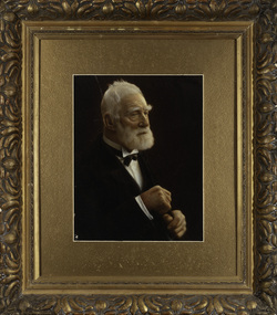
Photograph, James Venn Morgan, c.1905
James Venn Morgan was known affectionately as ‘The Father of Kew’. Born in Somersetshire on February 21, 1823, he sailed to Australia in April, 1851. James V. Morgan, was a member of one of the first parties to leave for the diggings. At Chewton, near Castlemaine his party tried their luck in an abandoned shaft, and in two weeks returned to Melbourne after having won 35lb weight of gold. James Venn Morgan was content with his success, and induced his partners to invest their money with him in land. After obtaining the advice of a friend, the party negotiated with Mr Samuel Watts, of Collingwood, who had recently purchased land from the Crown, and from him they took over at £15 an acre about 32 acres of land in the district that is now known as Kew. This land extended from where the Kew Post-office now stands to the locality of the Boroondara Cemetery. Here it was that Mr Morgan decided to settle, and, after having had the land surveyed, the partners apportioned it by drawing straws for the four sections into which it had been divided. One of them sold his holding later in the year for £100 an acre, and was sorry for it afterwards. In 1853 Mr. Morgan built the first house in Kew, and this house is the one in which he still resides. Here with his wife, he settled down to market gardening and dairying. So successful was the new venture that he induced his father and other members of the family to come out to Australia to assist him. Gradually the district became settled, Mr. Morgan parted with a portion of his holding, and subdivided and built on the remainder, which he still retained. In 1884 he found himself in a position to retire from active business.He celebrated his 100th birthday in 1923. He was later to die in the same year. The Argus, 17 January 1923.Rare and historic hand-tinted framed portrait of one of the founding pioneers of the district.Hand tinted photograph in a gilt frame of the Kew pioneer James Venn Morgan (1823-1923).james venn morgan, kew - pioneer families, kew - landowners -
 Kew Historical Society Inc
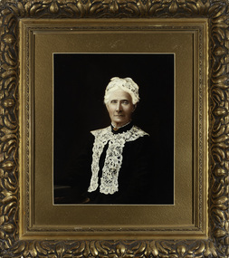
Photograph, Anna Morgan, c. 1905
James Venn Morgan was known affectionately as ‘The Father of Kew’. Born in Somersetshire on February 21, 1823, he sailed to Australia in April, 1851. James V. Morgan, was a member of one of the first parties to leave for the diggings. At Chewton, near Castlemaine his party tried their luck in an abandoned shaft, and in two weeks returned to Melbourne after having won 35lb weight of gold. James Venn Morgan was content with his success, and induced his partners to invest their money with him in land. After obtaining the advice of a friend, the party negotiated with Mr Samuel Watts, of Collingwood, who had recently purchased land from the Crown, and from him they took over at £15 an acre about 32 acres of land in the district that is now known as Kew. This land extended from where the Kew Post-office now stands to the locality of the Boroondara Cemetery. Here it was that Mr Morgan decided to settle, and, after having had the land surveyed, the partners apportioned it by drawing straws for the four sections into which it had been divided. One of them sold his holding later in the year for £100 an acre, and was sorry for it afterwards. In 1853 Mr. Morgan built the first house in Kew, and this house is the one in which he still resides. Here with his wife, he settled down to market gardening and dairying. So successful was the new venture that he induced his father and other members of the family to come out to Australia to assist him. Gradually the district became settled, Mr. Morgan parted with a portion of his holding, and subdivided and built on the remainder, which he still retained. In 1884 he found himself in a position to retire from active business. He celebrated his 100th birthday in 1923. He was later to die in the same year. The Argus, 17 January 1923.Rare and-tinted framed photograph af Annie Morgan, the wife of one of the founding pioneers of the district.Hand tinted photograph in a gilt frame of Anna Morgan (nee Chidgey), the wife of James Venn Morgan. Anna Morgan was the wife of one of Kew's earliest pioneers and landowners. She died in 1915.anna morgan, kew - pioneers -
 Kew Historical Society Inc
Document, Irena Higgins, Kew Children's Cottages, 1952-1964
---, ---, Cottages Liaison Committee members, pp. 4&5 ---, (---), (Untitled), p.4. ---, (---), [Memo re feedback from Official Visitors Conference at Royal Park], p.1. ---, (---), [Patient profile proforma], pp.1-2. ---, (---), Admission to Children’s Cottages Kew, p.1. ---, (---), Admissions Procedure, pp.1-2. ---, (---), Chaplaincy, p.1. ---, (---), Children’s Cottages and Special School Kew - Open for Education Week, p.1. ---, (---), Children’s Cottages Kew, p. 1-2. ---, (---), Children’s Cottages Kew, p.1. ---, (---), Children’s Cottages, Kew - Pathology Request and Report Form, p. 1. ---, (---), Children’s Cottages? Kew, pp.1-4 ---, (---), Extracts From the Report of Dr. J. V. McCreery, first Superintendent, p.1. ---, (---), Kew Cottages Training Centre Brochure, pp.1. ---, (---), Kew Special School, pp.1-2. ---, (---), Notes for General Guidance of Officers in Charge of Idiot Children, p.1. ---, (---), Notes for General Guidance of Officers in Charge of Idiot Children, p.1. ---, (---), Notes for Student Groups, pp.1-6. ---, (---), Physiotherapy at the Children’s Cottages Kew, p.1. ---, (---), Preface to Brochure on Cottages, pp.1-2. ---, (---), The administrative staff comprises …, pp.1-2. ---, (---), Untitled, p.2. ---, (1958, 29 August), Notes from a meeting of Superintendents with Dr Dax and other superintendents, p.1. ---, (1958, October - December), Proposed Survey of Children’s Cottages, Kew, pp.1-6., and Case Sheet pp. 1-5. ---, (1961, 2 November), Untitled letter regarding finances and upgrades, p.1. ---, (1962, 25 October), Memorandum, p.1. ---, (1962), Children’s Cottages Kew [overview of activities], p.1. ---, (1962), Report for the Year 1962 [statistics], p.1. ---, (1963), The Children’s Cottages Kew, pp.1-3. ---, (1964, 10 September), Merchandise Project Children’s Welfare Fund, Kew Cottages Parents Association, p.1. ---, (1964, 26 May), [Draft] Preface to Brochure on Cottages, pp.1-2. ---, (1964, October), Report to the Twelfth Annual (Perth) Conference: Australian Council for the Mentally Retarded, Kew Cottages Parents Association, pp.1-2. ---, (1964), Children’s Welfare Fund: Disbursements July 1963 - September 1964. [Brady, Dr W.A.] , (---), Transfer of Patients from One Institution to Another, pp.1-3. [Higgins, Irena], (---), The Formation and Development of Kew Children’s Cottages Parent’s Association, pp.1-6. Ashburner, J.B., (---, ---), Notes and Instructions, Kew Mental Hospital, p.1. Ashburner, J.B., (1954, 1 April), Notices and Instructions, Kew Mental Hospital, pp.1-2. Ashburner, J.B., (1954, 10 February), Notices and Instructions, Kew Mental Hospital, pp.1-3. Ashburner, J.B., (1954, 10 March), Notices and Instructions, Kew Mental Hospital, p.1. Ashburner, J.B., (1954, 11 March), Notices and Instructions, Kew Mental Hospital, pp.1-4. Ashburner, J.B., (1954, 11 May), Notes and Instructions, Kew Mental Hospital, p.1. Ashburner, J.B., (1954, 12 March), Notices and Instructions, Kew Mental Hospital, pp.1-4. Ashburner, J.B., (1954, 12 May), Notes and Instructions, Kew Mental Hospital, p.1. Ashburner, J.B., (1954, 13 August), Notes and Instructions, Kew Mental Hospital, p.1. Ashburner, J.B., (1954, 13 May), Notes and Instructions, Kew Mental Hospital, pp.1-3. Ashburner, J.B., (1954, 14 April), Notes and Instructions, Kew Mental Hospital, pp.1-2. Ashburner, J.B., (1954, 15 April), Notes and Instructions, Kew Mental Hospital, p.1. Ashburner, J.B., (1954, 15 June), Notes and Instructions, Kew Mental Hospital, p.1-2. Ashburner, J.B., (1954, 16 July), Notes and Instructions, Kew Mental Hospital, p.1. Ashburner, J.B., (1954, 19 February), Notes and Instructions, Kew Mental Hospital, pp.1-2. Ashburner, J.B., (1954, 19 October), Notes and Instructions, Kew Mental Hospital, p.1. Ashburner, J.B., (1954, 2 April), Notices and Instructions, Kew Mental Hospital, pp.1-2. Ashburner, J.B., (1954, 2 July), Notes and Instructions, Kew Mental Hospital, p.1. Ashburner, J.B., (1954, 2 March), Annual Report for 1952, Kew Mental Hospital, pp.1-4. Ashburner, J.B., (1954, 20 August), Notes and Instructions, Kew Mental Hospital, pp.1-2. Ashburner, J.B., (1954, 21 October), Notes and Instructions, Kew Mental Hospital, p.1. Ashburner, J.B., (1954, 23 February), Notices and Instruction - Succinic Acid Treatment, Kew Mental Hospital, pp.1-2 Ashburner, J.B., (1954, 23 June), Notes and Instructions, Kew Mental Hospital, pp.1-2. Ashburner, J.B., (1954, 23 March), Notices and Instructions, Kew Mental Hospital, pp.1-2. Ashburner, J.B., (1954, 25 May), Notes and Instructions, Kew Mental Hospital, p.1. Ashburner, J.B., (1954, 27 April), Notes and Instructions, Kew Mental Hospital, pp.1-3. Ashburner, J.B., (1954, 27 May), Notes and Instructions, Kew Mental Hospital, p.1. Ashburner, J.B., (1954, 28 July), Notes and Instructions, Kew Mental Hospital, pp.1-2. Ashburner, J.B., (1954, 29 July), Notes and Instructions, Kew Mental Hospital, p.1. Ashburner, J.B., (1954, 3 September), Notes and Instructions, Kew Mental Hospital, p.1. Ashburner, J.B., (1954, 31 March), Notices and Instructions - Rations, Kew Mental Hospital, pp.1-4. Ashburner, J.B., (1954, 4 June), Notes and Instructions, Kew Mental Hospital, p.1. Ashburner, J.B., (1954, 4 May), Notes and Instructions, Kew Mental Hospital, p.1. Ashburner, J.B., (1954, 4 October), Notes and Instructions, Kew Mental Hospital, p.1. Ashburner, J.B., (1954, 6 April), Notes and Instructions, Kew Mental Hospital, p.1. Ashburner, J.B., (1954, 6 October), Notes and Instructions, Kew Mental Hospital, pp.1-2. Ashburner, J.B., (1954, 7 July), Notes and Instructions, Kew Mental Hospital, p.1. Ashburner, J.B., (1954, 5 February), Notices and Instructions, Kew Mental Hospital, p.1. Brady Dr. W.A. (1960, December), Newsletter to parents, pp.1-5 Brady, Dr W.A. (1965, 28 May), Letter to The Secretary, Mental Health Authority regarding waiting lists, p.1. Brady, Dr. W.A. (1963, 28 February) Annual Report [to the Secretary of the Mental Health Authority], pp.1-15 Brady, W.A., (1954, 9 April), Notes and Instructions, Kew Mental Hospital, pp.1-2. Brady, W.A., (1954, 15 December), Notes and Instructions, Kew Mental Hospital, p.1. Brady, W.A., (1954, 7 December), Notes and Instructions, Kew Mental Hospital, p.1. Brady, W.A., (1954, 9 November), Notes and Instructions, Kew Mental Hospital, p.1. Brady, W.A., (1955, 13 December), Notes and Instructions, Kew Mental Hospital, p.1. Brady, W.A., (1955, 14 December), Notes and Instructions, Kew Mental Hospital, p.1. Brady, W.A., (1955, 15 July), Notes and Instructions, Kew Mental Hospital, p.1. Brady, W.A., (1955, 20 June), Notes and Instructions, Kew Mental Hospital, p.1. Brady, W.A., (1955, 24 June), Notes and Instructions, Kew Mental Hospital, p.1. Brady, W.A., (1955, 24 October), Notes and Instructions, Kew Mental Hospital, p.1. Brady, W.A., (1955, 25 August), Notes and Instructions, Kew Mental Hospital, p.1. Brady, W.A., (1955, 29 March), Notes and Instructions, Kew Mental Hospital, p.1. Brady, W.A., (1955, 5 December), Notes and Instructions, Kew Mental Hospital, p.1. Brady, W.A., (1955, 8 November), Notes and Instructions, Kew Mental Hospital, p.1. Brady, W.A., (1955, 9 May), Notes and Instructions, Kew Mental Hospital, p.1. Brady, W.A., (1956, 6 January), Notes and Instructions, Kew Mental Hospital, p.1. Brady, W.A., (1961, 8 December), Invitation to a screening of Dr. Pitt’s “Brookland Experiment”, p.1. Brazier, ‘Mac’ (1964, February), Newsletter, Kew Cottages Parents Association, pp.1-2. Brazier, ‘Mac’, (1964, June), Newsletter, Kew Cottages Parents Association, pp.1-4. Brazier, ‘Mac’, (1964, April), Newsletter, Kew Cottages Parents Association, pp.1-4. Brazier, ‘Mac’, (1964, August), Newsletter, Kew Cottages Parents Association, pp.1-4. Brazier, ‘Mac’, (1964, December), Newsletter, Kew Cottages Parents Association, pp.1-4. [3 copies]. Brazier, ‘Mac’, (1964, July), Newsletter, Kew Cottages Parents Association, pp.1-4. Brazier, ‘Mac’, (1964, May), Newsletter, Kew Cottages Parents Association, pp.1-4. Brazier, ‘Mac’, (1964, November), Newsletter, Kew Cottages Parents Association, pp.1-5. Brazier, ‘Mac’, (1964, October), Newsletter, Kew Cottages Parents Association, pp.1-6. Brazier, ‘Mac’, (1964, September), Newsletter, Kew Cottages Parents Association, pp.1-4. Brazier, Betty (1964, 26 April), Letter to I Higgins re Distribution of newsletters to staff, Kew Cottages Parents Association. (p.1) Dale, (1964), A Few Facts About the Children’s Cottages Kew Fordyce, J., (1956, 13 January), Notes and Instructions, Kew Mental Hospital, p.1. Higgins, Irena (---), A Short History of the Children’s Cottages, Kew, pp.1-2. Higgins, Irena (1966, 28 November), Letter to Dr Brady regarding waiting lists, pp.1-3. Higgins, Irena, (---), ‘Children’s Cottages’, Kew, p. 1-2. Loveless, L.W., (1963, 18 July), [Commonwealth Department of Social Services] ‘Approval of Children’s Cottages as an endowed Institution’, p.1. M.H. 11, Schedule 17 Section 41 (2) (b), ‘Request of Medical Practitioner for Admission of Voluntary patient to a Training Centre or Private Training Centre’, Mental Health Regulations 1962, p.1. M.H. 12, Section 41 (10) (a) (b) (c), ‘Order for the Discharge of a Voluntary Patient’, Mental Health Regulations 1962, p.1. M.H. 13, Section 41 (10) (d), ‘Application for Discharge by Voluntary Patient and Order for Discharge’, Mental Health Regulations 1962, p.1. M.H. 14, Section 41 (1), Application for Leave of Absence for Voluntary Patient, Mental Health Regulations 1962, p.1. M.H. 2, Schedule 9 Section 41 (a) 41 (b) 42 (1) 43 (1) 44 (1) 48, 59 (1) (2) ‘Statement of Personal Details of Patient’, Mental Health Regulations 1962, p.1-2. M.H. 21, Schedule 9 Section 44 (1) 48 and 52, Medical Approval for Admission to Training Centre, Mental Health Regulations 1962, pp.1-2. M.H. 22, Schedule 25 Section 44, Request to Receive a Patient into a Training Centre, Mental Health Regulations 1962, p.1. M.H. 33, Schedule 40, Section 62, Notice of Death, Mental Health Regulations 1962, p.1. M.H. 37, Section 87 (1), Application and Approval for Trial Leave, Recommended and Approved Patients, Mental Health Regulations 1962, p.1. M.H. 39, Section 93 (1), Order of Superintendent for Discharge of Patient on Leave Upon Production of Medical Certificate, Mental Health Regulations 1962, p.1. M.H. 40, Section 94 (1), Order of Superintendent for Discharge of Patient, Mental Health Regulations 1962, p.1. M.H. 43, Section 102, Consent of the Chief medical Officer or Superintendent for Anaethesia or Surgical Operation Upon a Patient, Mental Health Regulations 1962, p. 1. M.H. 7, Schedule 14 Section 41 (2) (a) (i) and (ii), ‘Application for Admission of Voluntary Patient to a Training Centre or Private Training Centre by Parent or Guardian’, Mental Health Regulations 1962, p.1. M.H. 9, Schedule 16 Section 41 (2) (a) (ii), ‘Application for Admission to a Training Centre as a Voluntary Patient’, Mental Health Regulations 1962, p.1. Medical Officers (1958, 11 October), Percentage of deaths and statistics for the years 1955 to 1957, Report to Dr. E.C. Dax, Chairman, Mental Health Authority, pp. 1-2. Plumridge, Len, (1964), Statement of Receipts & Expenditure 1963-1964: Children’s Welfare Fund, Kew Cottages Parents Association, p.1. Temby, E., (---), The Kew Cottages Parents’ Association, p. 1-2. Temby, Ethel, (1964, October), Proceedings of the Twelfth Annual Conference, Australian Council for the Mentally Retarded, pp.1-2. Temby, Ethel, (1964, September), [Information Committee] Sixth Annual Report pp.1-2 Temby, Ethel, (1964, September), Information Committee: Sixth Annual Report, pp.1-2 Wann, E.M., (1956, 16 March), Memo [regarding the overcrowding crisis], p. 1. WM.7663 (---), Children’s Cottages Kew E.4 [overview and personnel], pp. 1-2.An important manuscript comprising original and reproduced materials from the period 1952-1964 assembled by and for senior staff at the Children's Cottages, Kew.Sorted folio of original manuscripts and printed material from the 1950s and 1960s relating to the Kew Cottages created by Irena Higgins, senior social worker at the Kew Mental Hospital and Kew Cottages. The material later formed part of the collection of Dr Cliff Judge, resident psychiatrist at the Cottages. Material within the folio includes original typescripts created by Irena Higgins, copies of newsletters by various Superintendent and Deputy Superintendent Psychiatrists including Dr A.W. Brady, and published and unpublished reports to relevant mental health departments.mental health - victoria - history, chidren's cottages - kew, irana higgins, dr cliff judge, dr. a.w. brady -
 Kew Historical Society Inc
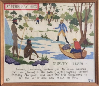
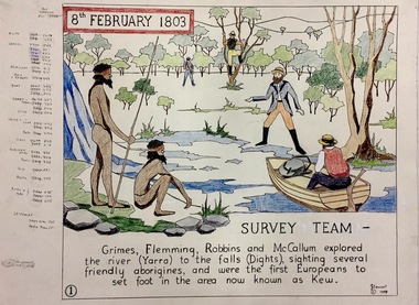
Textile - Bicentennial tapestry, 1. Survey Team, 8th February 1803, 1988
This is one of eight embroidered panels, completed during the 1988 Australian Bi-Centennial, and carried out under the auspices of City of Kew Council and the Kew Historical Society. Nearly 600 residents, including many children, participated in their production by adding a few or more stitches. A book records their names and the panels upon which they worked. Artist: Joy Stewart / Co-ordinator: Dorothy Benyei.1. Survey Team. A framed embroidery created by adults and children of the City of Kew as a Bicentennial project, based on a design by the artist Joy Stewart. Five of the six completed embroideries created in the project are/were displayed in the Kew Library. [The five embroidered panels have now been temporarily removed for conservation reasons].Inscription: "SURVEY TEAM 8th February 1803 / Grimes, Flemming, Robbins and McCallum explored the river (Yarra) to the falls (Dights), sighting several friendly Aborigines, and were the first Europeans to set foot in the area now known as Kew." Embroidered signature of the artist: "(c) JStewart, 1988"bicentennial project (kew), joy stewart, charles grimes expedition, australian bicentennial -
 Kew Historical Society Inc
Journal, Kewriosity : April 1986
School's in at Kew Council [Deepdene Primary School; Sacred Heart Primary School; MLC] / p1. Who reads Kewriosity? [survey] / p1&8. Dates for April / p2. [Community] Notices / p2&8. Update - Notes from Council - Commentary [Local Government; Australian Constitutional Convention] / p3. Some spare hours to fill?? [Kew Community Bus] / p3. Traffic management / p3. In Brief [Concern over outdoor advertising; Fenced in for safety - Denmark Street Infant Welfare Centre; The latest on Safeway] / p4. Profile - Cr Chester Keon-Cohen / p4. The Gladstone College saga: Part 3 / p5. They call her "Amazing Grace" [Grace Chambers] / p5. Kew Community House [Migrant English; Photocopier; Term II] / Rhonda McCaw p6. Kew families needed [Inner East Foster care] / p6. Ramblings of Kew's last cowboy - First of a new series of articles by Bill Stent [Dairy farms] / Bill Stent p7. Care-Force needs new financial supporters / p7. Footy news [Kew Football Club] / p8.Kewriosity was a local newsletter combining Kew Council and community news. It was published between November 1983 and June 1994, replacing an earlier Kewriosity [broad] Sheet (1979-84). In producing Kewriosity, Council aimed to provide a range of interesting and informative articles covering its deliberations and decision making, together with items of general interest and importance to the Kew community and information not generally available through daily media outlets.non-fictionSchool's in at Kew Council [Deepdene Primary School; Sacred Heart Primary School; MLC] / p1. Who reads Kewriosity? [survey] / p1&8. Dates for April / p2. [Community] Notices / p2&8. Update - Notes from Council - Commentary [Local Government; Australian Constitutional Convention] / p3. Some spare hours to fill?? [Kew Community Bus] / p3. Traffic management / p3. In Brief [Concern over outdoor advertising; Fenced in for safety - Denmark Street Infant Welfare Centre; The latest on Safeway] / p4. Profile - Cr Chester Keon-Cohen / p4. The Gladstone College saga: Part 3 / p5. They call her "Amazing Grace" [Grace Chambers] / p5. Kew Community House [Migrant English; Photocopier; Term II] / Rhonda McCaw p6. Kew families needed [Inner East Foster care] / p6. Ramblings of Kew's last cowboy - First of a new series of articles by Bill Stent [Dairy farms] / Bill Stent p7. Care-Force needs new financial supporters / p7. Footy news [Kew Football Club] / p8. publications -- city of kew (vic.), kewriosity, council newsletters, community newsletters -
Kew Historical Society Inc
Journal, Kewriosity : October 1984
... ; Resident Attitude Survey] / p1. [Anglican] Archbishop's first visit ...[Kew] Recreation Centre update [The Committee; Resident Attitude Survey] / p1. [Anglican] Archbishop's first visit to East Kew [St Paul's Church] / p1. Community [Asian Evangelical Fellowship; Hyde Park Fellowship; Kew Baptist Church; Kew Native Plant Group; Kew Garden Club; Kew (Daytime) Garden Club; Fashion Parade; The Rheumatism and Arthritis Foundation of Victoria; Retiring?; Anyone for tennis?; Games evening] / p2. Council - Mayoral Column / Cr Robin Saunders / p3. New Depot / p3. Library News / p3. Calling on people with disabilities in Kew / p3. Dieback in Kew's Plane Trees / p3. Kew's new Councillors - Roger Streeton; Chester Keon-Cohen] / p4. Kew Junction Shopping Centre - Liftout Guide / p5-6, 11-12. Youth Pages - Welcome / p7. Earth Club Camps / Phil Smith p7. Training the oldies / Elizabeth Trapani p7. Holiday fun around Kew / p8&9. Things to do in Kew / p10. A bit further afield / p10. Community - Artisst take dance , drama & art to the streets / p13. Asthma Foundation / p13. Council - More thoughts about the Community House / p14. 1985 Kew Festival / p14. Development Plan for Lower Yarra / p15. Jackie Kookaburra goes to Sea / p15. Migrant woman candidate for Kew [Anna-Maria Dierer, ALP] / p15. Council/Community - Traffic Management; New Residents' Kit; Family Fun Day [East Kew Uniting Church]; Older Person's Action Centre; Kew Citizens' Band - Engagement list / p16.Kewriosity was a local newsletter combining Kew Council and community news. It was published between November 1983 and June 1994, replacing an earlier Kewriosity [broad] Sheet (1979-84). In producing Kewriosity, Council aimed to provide a range of interesting and informative articles covering its deliberations and decision making, together with items of general interest and importance to the Kew community and information not generally available through daily media outlets.non-fiction[Kew] Recreation Centre update [The Committee; Resident Attitude Survey] / p1. [Anglican] Archbishop's first visit to East Kew [St Paul's Church] / p1. Community [Asian Evangelical Fellowship; Hyde Park Fellowship; Kew Baptist Church; Kew Native Plant Group; Kew Garden Club; Kew (Daytime) Garden Club; Fashion Parade; The Rheumatism and Arthritis Foundation of Victoria; Retiring?; Anyone for tennis?; Games evening] / p2. Council - Mayoral Column / Cr Robin Saunders / p3. New Depot / p3. Library News / p3. Calling on people with disabilities in Kew / p3. Dieback in Kew's Plane Trees / p3. Kew's new Councillors - Roger Streeton; Chester Keon-Cohen] / p4. Kew Junction Shopping Centre - Liftout Guide / p5-6, 11-12. Youth Pages - Welcome / p7. Earth Club Camps / Phil Smith p7. Training the oldies / Elizabeth Trapani p7. Holiday fun around Kew / p8&9. Things to do in Kew / p10. A bit further afield / p10. Community - Artisst take dance , drama & art to the streets / p13. Asthma Foundation / p13. Council - More thoughts about the Community House / p14. 1985 Kew Festival / p14. Development Plan for Lower Yarra / p15. Jackie Kookaburra goes to Sea / p15. Migrant woman candidate for Kew [Anna-Maria Dierer, ALP] / p15. Council/Community - Traffic Management; New Residents' Kit; Family Fun Day [East Kew Uniting Church]; Older Person's Action Centre; Kew Citizens' Band - Engagement list / p16. publications -- city of kew (vic.), kewriosity, council newsletters, community newsletters -
Kew Historical Society Inc
Journal, The Kewriosity Sheet Vol.1 No.6 : November 1979
What's doing in Kew for November / p1. Evaluation time! [Survey: The Kewriosity Sheet] / p1. Your news is good news / p1. Kew Op Shop / p1. Do it yourself duplicating [The Copy Shop] / p1. Toastmasters Club commences in Kew / p2. Hey kids!! Did you know? / p2. Park is beautiful asset [Yarra Bend Park; Studley Park Progress Association] / p2. Jobs wanted / p2. Kew Philharmonic Society / p2. Eat Kew Primary School [Reading; Concert Band] / p2. Playgroup [Uniting Church Highbury Grove] / p2. Show, Sell and Tell night [Gardening] / p2. Council News [Home help; A new group in Kew; Swimming Pool; Immunisations; Dog registrations; Valuations; Rates] / p2.The Kewriosity Sheet (1979-83) was first published in the City of Kew (Victoria) in June 1979 as a two-sided 'community newssheet'. It aimed to: 'share news about Kew happenings and Kew people, and to exchange ideas about living in Kew'. Later issues gradually evolved into a 4-page, quarto sized publication. The Kewriosity Sheet was superseded by the Kew Council publication 'Kewriosity' (1983-1994).non-fictionWhat's doing in Kew for November / p1. Evaluation time! [Survey: The Kewriosity Sheet] / p1. Your news is good news / p1. Kew Op Shop / p1. Do it yourself duplicating [The Copy Shop] / p1. Toastmasters Club commences in Kew / p2. Hey kids!! Did you know? / p2. Park is beautiful asset [Yarra Bend Park; Studley Park Progress Association] / p2. Jobs wanted / p2. Kew Philharmonic Society / p2. Eat Kew Primary School [Reading; Concert Band] / p2. Playgroup [Uniting Church Highbury Grove] / p2. Show, Sell and Tell night [Gardening] / p2. Council News [Home help; A new group in Kew; Swimming Pool; Immunisations; Dog registrations; Valuations; Rates] / p2.community publications --- kew (vic.), the kewriosity sheet, newsletters - kew (vic.) -
Kew Historical Society Inc
Journal, The Kewriosity Sheet Vol.1 No.8 : January 1980
What's doing in Kew January 1980 / p1. Police Message [Intruders; Strangers] / p1. What do you do when no-one seems to have the right answer [Citizens Advice Bureau] / p1. Protect your car / p2. Be alert to anything suspicious: Never admit to callers that you are alone / p2. Kew High School Holiday Program / p2. Street Bar-b-que [Uvadale Grove] / p2. Can you help? Just once! [Meals on Wheels drivers] / p2. Kampuchea [Cambodia] Record Event [East Kew Uniting Church Youth Group] / p2. A.R.A.F.E.M.I. at the Citizens' Advice Bureau [Association of Relatives and Friends of the Emotionally and Mentally III] / p2. Council News [Summer Ground allocation; Flats survey in Kew] / p2. Living in Kew [Kew Family and Community Services (F.A.C.S.) Committee] / p2.The Kewriosity Sheet (1979-83) was first published in the City of Kew (Victoria) in June 1979 as a two-sided 'community newssheet'. It aimed to: 'share news about Kew happenings and Kew people, and to exchange ideas about living in Kew'. Later issues gradually evolved into a 4-page, quarto sized publication. The Kewriosity Sheet was superseded by the Kew Council publication 'Kewriosity' (1983-1994).non-fictionWhat's doing in Kew January 1980 / p1. Police Message [Intruders; Strangers] / p1. What do you do when no-one seems to have the right answer [Citizens Advice Bureau] / p1. Protect your car / p2. Be alert to anything suspicious: Never admit to callers that you are alone / p2. Kew High School Holiday Program / p2. Street Bar-b-que [Uvadale Grove] / p2. Can you help? Just once! [Meals on Wheels drivers] / p2. Kampuchea [Cambodia] Record Event [East Kew Uniting Church Youth Group] / p2. A.R.A.F.E.M.I. at the Citizens' Advice Bureau [Association of Relatives and Friends of the Emotionally and Mentally III] / p2. Council News [Summer Ground allocation; Flats survey in Kew] / p2. Living in Kew [Kew Family and Community Services (F.A.C.S.) Committee] / p2. community publications --- kew (vic.), the kewriosity sheet, newsletters - kew (vic.) -
Kew Historical Society Inc
Journal, The Kewriosity Sheet Vol.1 No.11 : April 1980
What's doing in Kew April / p1. "Leisure Time": What do you do with your leisure time? [multiple choice survey] / p1. Kew Philharmonic Society / p1. Bingo / p1. The hobby of Kings [Kew Philatelic Society] / p2. Kew Chess Club / p2. Kew High School Library / p2. Do you know? [St Peter Claver Mission Youth Group] / p2. Overton Fete [Overton Home for the Aged] / p2. Kew Historical Society / Elizabeth Mackie p2. Health & Human Relationships [Wesley College] / p2. Can you help Kew High School? [Work Experience] / p2. The Sunrise Service, Easter Sunday / p2. Fashion Parade [Pierre Cardin, Lioness Club of Kew] / p2. After School Activities: Kew High School / p2. Mayoral Neighbourhood Barbeque.The Kewriosity Sheet (1979-83) was first published in the City of Kew (Victoria) in June 1979 as a two-sided 'community newssheet'. It aimed to: 'share news about Kew happenings and Kew people, and to exchange ideas about living in Kew'. Later issues gradually evolved into a 4-page, quarto sized publication. The Kewriosity Sheet was superseded by the Kew Council publication 'Kewriosity' (1983-1994).non-fictionWhat's doing in Kew April / p1. "Leisure Time": What do you do with your leisure time? [multiple choice survey] / p1. Kew Philharmonic Society / p1. Bingo / p1. The hobby of Kings [Kew Philatelic Society] / p2. Kew Chess Club / p2. Kew High School Library / p2. Do you know? [St Peter Claver Mission Youth Group] / p2. Overton Fete [Overton Home for the Aged] / p2. Kew Historical Society / Elizabeth Mackie p2. Health & Human Relationships [Wesley College] / p2. Can you help Kew High School? [Work Experience] / p2. The Sunrise Service, Easter Sunday / p2. Fashion Parade [Pierre Cardin, Lioness Club of Kew] / p2. After School Activities: Kew High School / p2. Mayoral Neighbourhood Barbeque.community publications --- kew (vic.), the kewriosity sheet, newsletters - kew (vic.) -
 Kew Historical Society Inc
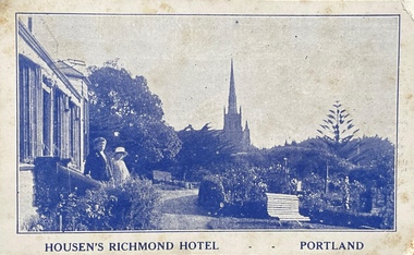
Postcard, Housen's Richmond Hotel | Portland
Many of the Henty's of the Western District of Victoria also owned houses in Kew, Victoria. Stephen Henty, referred to on the reverse of the postcard, lived while a member of the Vitoria Parliament at 'Findon' in Kew. Kew Historical Society also holds a nationally significant collection of costumes belonging to three generations of Henty women.Monochrome, blue tinted 'real photo' postcard of Housen's Richmond Hotel, Portland. Two women stand on the steps of the hotel at left, with the rose garden in front of them. Behind them is a church spire. The hotel and its significance is outlined in two columns of blue coloured text on the reverse.Printed reverse: "THE RICHMOND is the most historical building in the State. On the site of today's building Edward Henty, the founder of permanent settlement in Victoria, commenced his first house February 19, 1835, finishing the work in two months. He had landed in Portland on Nov. 19th, 1834, and turned the first plough furrows in Victoria where the Hotel now stands on the 26th of the following month. It was also here that Major Mitchell ended his explorations from Sydney, meeting the Hentys on August 29th, 1836. In December of the same year Mrs S. G. Henty joined her husband, their son Richmond, the first male white child in Portland, being born in the Henty cottage. The present Richmond Hotel was built in 1840, and became the home of Stephen Henty until his departure from Portland in 1869. Though Edward Henty's first house was demolished in 1840, to make room for the new surveyed town streets, part of his wool store remains in the Hotel grounds, and is used as a wood shed. This is about the oldest building in the State : in it was held the first christening service in Portland on September 26th, 1841. On the site of the Richmond Hotel all the early visiting celebrities were entertained - Mitchell, Wedge, La Trobe, Fyans, Sir John Franklin, Capt. Stokes, etc. No other hostelry in Victoria can give you the historical atmosphere of the RICHMOND. / THE ORIGINAL HOME OF THE HENTYS."henty family, richmond hotel -- portland (vic.), stephen henty, edward henty, richmond henty, henty houses -- victoria, portland, postcards -
 Kew Historical Society Inc
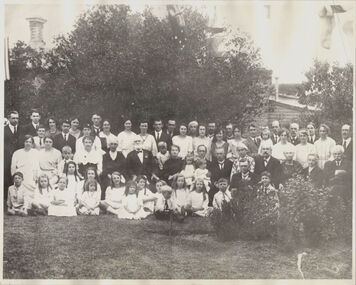
Photograph, James Venn Morgan's 100th Birthday, 1923
1823-1923.MR. JAMES VENN MORGAN. "FATHER OF" KEW."In a Village in Somersetshire in England on February 21, 1823, a son was born to George and Sarah Morgan. The child was so delicate that his parents feared that he would not live. How little ground the parents parents had for their fears may be judged from the fact that the boy, christened James Venn Morgan is still alive and hale. He is able to exhibit with pride the paper with its faded ink on which a clergyman wrote the certificate of his baptism almost 100 years ago. But for some slight infirmities of sight and hearing, Mr. Morgan, who is within six weeks of completing the 100th year of his life, is in good health, and is well able to attend to his business affairs. His immediate cause for regret is that he is not now able to do a day's work in his garden, as he was 12 months ago. After spending his early life in England, where he learned his trade as shoemaker, Mr Morgan came to Australia in April, 1851. He carried letters of introduction to Mr. Tripp, a solicitor, of Melbourne, who strongly recommended him to begin business as a shoemaker, and accordingly he opened a shop at the corner of Swanston and Bourke streets, where the Leviathan Stores now stand, and was not long in working up a good connection. Among his customers at that time Mr. Morgan recalls Mr. Justice A'Beckett and many leading men in law and medicine of the day. Then the news was flashed through Melbourne of the discovery of gold at Ballarat. Nothing can give a clearer idea of the excitement this news caused in Melbourne than that Mr. Morgan, who was a member of one of the first parties to leave for the diggings, left uncompleted in his workshop one of a pair of riding boots he was making for Mr. J. B. Weir. As the purchase of suitable clothing would have taken time, he set out to make his fortune wearing a top hat. At Ballarat he stayed for five or six weeks, and returned to Melbourne with 10oz. of gold. He remained in the city long enough to finish the second of the two riding boots, and then, with three companions, set out for Chewton, near Castlemaine. Here fortune smiled. The party tried their luck in an abandoned shaft, and in two weeks returned to Melbourne again after having won 35lb. weight of gold. How Kew Was Born. Mr Morgan was content with his success, and induced his partners to invest their money with him in land. After obtaining the advice of a friend, the party negotiated with Mr Samuel Watts, of Collngwood, who had recently purchased land from the Crown, and from him they took over at £15 an acre about 32 acres of land in the district that is now known as Kew. This land extended from where the Kew Post-office now stands to the locality of the Boroondara Cemetery. At that time there was not a house in the district, and there was a fairly large population of aborigines, but no white men. Here it was that Mr Morgan decided to settle, and, after having had the land surveyed, the partners apportioned it by drawing straws for the four sections into which it had been divided. One of them sold his holding later in the year for £100 an acre, and was sorry for it afterwards. In 1853 Mr. Morgan built the first house in Kew, and this house is the one in which he still resides. Here with his wife, he settled down to market gardening and dairying. He tells with a laugh how he was paid 1/ a lb for the first potatoes he grew, and 1/ a quart for milk. So successful was the new venture that he induced his father and other members of the family to come out to Australia to assist him. How different Kew of those days was from the Kew of to-day will be understood from Mr. Morgan's statement that for weeks at a time they never saw a a white face other than those of the family. The blacks, he says, although very noisy, were entirely friendly. Gradually the district became settled, Mr. Morgan parted with a portion of his holding, and subdivided and built on the remainder which he still retains. In 1884 he found himself in a position to retire from active business. Youth in Old Age. In Mr Morgan's garden, which is a large, one trees which he and his father planted more than 60 years ago are still bearing heavy crops of apples. Mr. Morgan has been a widower since 1915. He has three daughters all of whom are married, and numerous grandchildren and great-grandchildren. One of the great-grand children reccntly informed Mr. Morgan that he was about to be married. Perhaps the most striking characteristic of Mr. Morgan to-day is his activity. Not only does he move about with surprising alacrity, but is able to go into the streets and attend to his business affairs with but little fatigue The Argus, 17 January 1923, p.12.This work forms part of the collection assembled by the historian Dorothy Rogers, that was donated to the Kew Historical Society by her son John Rogers in 2015. The manuscripts, photographs, maps, and documents were sourced by her from both family and local collections or produced as references for her print publications. Many were directly used by Rogers in writing ‘Lovely Old Homes of Kew’ (1961) and 'A History of Kew' (1973), or the numerous articles on local history that she produced for suburban newspapers. Most of the photographs in the collection include detailed annotations in her hand. The Rogers Collection provides a comprehensive insight into the working habits of a historian in the 1960s and 1970s. Together it forms the largest privately-donated collection within the archives of the Kew Historical Society.A group portrait on the occasion of the 100th birthday of James Venn Morgan in 1923. Dorothy Rogers used this photograph in 'A History of Kew' (1973). It faces page 17. In the book, the caption reads "JAMES VENN MORGAN'S 100TH BIRTHDAY ANNIVERSARY. The party was held at 'Morganville'. Mr Morgan is shown with a group of descendants."James Morgans 100th Birthday Party. james venn morgan, kew, model dairy, dorothy rogers -
 Kew Historical Society Inc
Plan - Subdivision Plan, Jas R Mathers Son & McMillan, Clifton Estate, Kew, c. 1916
... year when the ‘Clifton Estate’ was surveyed, subdivided... the ‘Clifton Estate’ was surveyed, subdivided and first auctioned ...Pru Sanderson, in her groundbreaking ‘City of Kew Urban Conservation Study : Volume 2 - Development History’ (1988), summarised the periods of urban development and subdivisions of land in Kew. The periods that she identified included 1845-1880, 1880-1893, 1893-1921, 1921-1933, 1933-1943, and Post-War Development. These periods were selected as they represented periods of rapid growth or decline in urban development. An obvious starting point for Sanderson’s groupings involved population growth and the associated economic cycles. These cycles also highlighted urban expansion onto land that was predominantly rural, although in other cases it represented the decline and breakup of large estates. A number of the plans in the Kew Historical Society’s collection can also be found in other collections, such as those of the State Library of Victoria and the Boroondara Library Service. A number are however unique to the collection.The Kew Historical Society collection includes almost 100 subdivision plans pertaining to suburbs of the City of Melbourne. Most of these are of Kew, Kew East or Studley Park, although a smaller number are plans of Camberwell, Deepdene, Balwyn and Hawthorn. It is believed that the majority of the plans were gifted to the Society by persons connected with the real estate firm - J. R. Mathers and McMillan, 136 Cotham Road, Kew. The Plans in the collection are rarely in pristine form, being working plans on which the agent would write notes and record lots sold and the prices of these. The subdivision plans are historically significant examples of the growth of urban Melbourne from the beginning of the 20th Century up until the 1980s. A number of the plans are double-sided and often include a photograph on the reverse. A number of the latter are by noted photographers such as J.E. Barnes.The Clifton Estate was an ambitious subdivision. It included 61 allotments bordering Cotham and Park Hill Roads, and Florence and Adeney Avenues. It is difficult to ascertain the exact year when the ‘Clifton Estate’ was surveyed, subdivided and first auctioned. The uncertainty may be due to allotments being released during the First World War. The subdivision took its name from the house ‘Clifton’ (lot 5) on the corner of Adeney Avenue and Cotham Road. The outline of Clifton (since demolished) and the extent of its land following the subdivision are represented on the plan. The auctioneers have also shown ‘Maryfield’ and ‘Wimba’, the neighbouring properties in Cotham Road, on the plan."B"subdivision plans - kew, clifton estate, cotham road, adeney avenue, florence avenue, park hill road -
 Kew Historical Society Inc
Work on paper, Joy Stewart, 1. Survey Team, 1988
Kew Tapestry. The eight panels depict the history of Kew. This was a 1988 Australian Bi-Centennial Project carried out under the auspices of City of Kew Council and the Kew Historical Society Incorporated. Nearly 600 citizens including many children participated in the production by adding a few or more stitches. A book records their names and the panels upon which they worked. Artist: Joy Stewart Co-ordinator: Dorothy BenyeiSydney Joy (Joy) Stewart was born in Melbourne 1925. She studied at Swinburne Technical College Art School from 1941-1945, then the National Gallery Art School 1946-1948. Her career included employment positions as a display artist, designer/painter, gallery assistant, and art teacher. Joy relocated to Cairns in 1981. Solo exhibitions in Melbourne and Cairns, including 'Done By Me' at Cairns Regional Gallery in 1999. Group exhibitions at Cairns Regional Gallery, 'The Fish John West Regrets, 1993' and 'Facets of Life' 1994. Joy Stewart died in Cairns in 2018.1. Survey Team. A Handcoloured cartoon created by the artist Joy Stewart as a template for the first of a series of embroidered panels depicting the history of Kew. Wool colour codes at left. Inscription: "8th February 1803. SURVEY. Grimes, Flemming (sic), Robbins and McCallum explored the river (Yarra) to the falls (Dights), sighting several friendly aborigines, and were the first Europeans to set foot in the area now known as Kew". Signed by the artist "(c) JStewart, 1988"bicentennial project (kew), joy stewart -
 Kew Historical Society Inc
Plan, Melbourne & Metropolitan Board of Works : Borough of Kew : Detail Plan No.1291, 1905
The Melbourne and Metropolitan Board of Works (MMBW) plans were produced from the 1890s to the 1950s. They were crucial to the design and development of Melbourne's sewerage and drainage system. The plans, at a scale of 40 feet to 1 inch (1:480), provide a detailed historical record of Melbourne streetscapes and environmental features. Each plan covers one or two street blocks (roughly six streets), showing details of buildings, including garden layouts and ownership boundaries, and features such as laneways, drains, bridges, parks, municipal boundaries and other prominent landmarks as they existed at the time each plan was produced. (Source: State Library of Victoria). This plan forms part of a large group of MMBW plans and maps that was donated to the Society by the Mr Poulter, City Engineer of the City of Kew in 1989. Within this collection, thirty-five hand-coloured plans, backed with linen, are of statewide significance as they include annotations that provide details of construction materials used in buildings in the first decade of the 20th century as well as additional information about land ownership and usage. The copies in the Public Record Office Victoria and the State Library of Victoria are monochrome versions which do not denote building materials so that the maps in this collection are invaluable and unique tools for researchers and heritage consultants. A number of the plans are not held in the collection of the State Library of Victoria so they have the additional attribute of rarity.Original survey plan, issued by the MMBW to a contractor with responsibility for constructing sewers in the area identified on the plan within the Borough of Kew. The plan was at some stage hand-coloured, possibly by the contractor, but more likely by officers working in the Engineering Department of the Borough and later Town, then City of Kew. The hand-coloured sections of buildings on the plan were used to denote masonry or brick constructions (pink), weatherboard constructions (yellow), and public buildings (grey). A detail plan of part of Studley Park bordered by the major streets of Hodgson Street, Stevenson Street and Studley Park Road. Included on the plan are a number of significant Studley Park mansions in existence at the beginning of the 20th century. The unnamed street shown in the middle of the plan is McEvoy Street. The most important house still extant is Campion House, formerly named Dalsraith [Dalswraith] and Glendalough, owned since the 1940s by the Society of Jesus. Campion House can be seen on the corner of Hodgson and Studley Park Road. Its stables at the rear of the block have now been incorporated into a contemporary residence. An interesting feature of the plan is the 1910 annotation by Ed Seitz, professional designing engineer. Is Seitz the contractor who modified the MMBW original?melbourne and metropolitan board of works, detail plans, mmbw 1291, cartography -
 Kew Historical Society Inc
Plan, Melbourne and Metropolitan Board of Works, Melbourne & Metropolitan Board of Works : Borough of Kew : Detail Plan No.1294 & 1295, 1904
The Melbourne and Metropolitan Board of Works (MMBW) plans were produced from the 1890s to the 1950s. They were crucial to the design and development of Melbourne's sewerage and drainage system. The plans, at a scale of 40 feet to 1 inch (1:480), provide a detailed historical record of Melbourne streetscapes and environmental features. Each plan covers one or two street blocks (roughly six streets), showing details of buildings, including garden layouts and ownership boundaries, and features such as laneways, drains, bridges, parks, municipal boundaries and other prominent landmarks as they existed at the time each plan was produced. (Source: State Library of Victoria). This plan forms part of a large group of MMBW plans and maps that was donated to the Society by the Mr Poulter, City Engineer of the City of Kew in 1989. Within this collection, thirty-five hand-coloured plans, backed with linen, are of statewide significance as they include annotations that provide details of construction materials used in buildings in the first decade of the 20th century as well as additional information about land ownership and usage. The copies in the Public Record Office Victoria and the State Library of Victoria are monochrome versions which do not denote building materials so that the maps in this collection are invaluable and unique tools for researchers and heritage consultants. A number of the plans are not held in the collection of the State Library of Victoria so they have the additional attribute of rarity.Original survey plan, issued by the MMBW to a contractor with responsibility for constructing sewers in the area identified on the plan within the Borough of Kew. The plan was at some stage hand-coloured, possibly by the contractor, but more likely by officers working in the Engineering Department of the Borough and later Town, then City of Kew. The hand-coloured sections of buildings on the plan were used to denote masonry or brick constructions (pink), weatherboard constructions (yellow), and public buildings (grey).The streets and built structures in MMBW Detail Plan 1294 & 1295 were surveyed in 1903 and released to contractors in 1904. This plan is one of two in the collection where the lithographers amalgamated two separate plans. Both plans include sections of Studley Park. Dominating the south and west corners of Kew Junction are the Clifton and Kew Hotels. The Kew Hotel, owned by Patrick O’Shaughnessy was one of the oldest in Kew. MMBW plans were amended over time to take account of new subdivisions such as that which created Merrion Place. Of the four mansions shown in Studley Park Road, three remain – ‘Field Place’, the home of Frances Henty, ‘Leaghur’ and ‘Darley’. ‘Byram’ (later ‘Goathland’, then ‘Tara Hall’) was an architectural marvel. Designed in 1888 by E.G. Kilburn for the paper magnate George Ramsden, it was demolished in 1960. While an earlier sale of the southern section of Byram had created Tara Avenue in 1927, the demolition of the house in 1960 enabled the extension of Tara Avenue northward.melbourne and metropolitan board of works, detail plans, mmbw 1294, mmbw 1295, cartography -
 Kew Historical Society Inc
Plan, Melbourne & Metropolitan Board of Works : Borough of Kew : Detail Plan No.1296, 1904
The Melbourne and Metropolitan Board of Works (MMBW) plans were produced from the 1890s to the 1950s. They were crucial to the design and development of Melbourne's sewerage and drainage system. The plans, at a scale of 40 feet to 1 inch (1:480), provide a detailed historical record of Melbourne streetscapes and environmental features. Each plan covers one or two street blocks (roughly six streets), showing details of buildings, including garden layouts and ownership boundaries, and features such as laneways, drains, bridges, parks, municipal boundaries and other prominent landmarks as they existed at the time each plan was produced. (Source: State Library of Victoria)This plan forms part of a large group of MMBW plans and maps that was donated to the Society by the Mr Poulter, City Engineer of the City of Kew in 1989. Within this collection, thirty-five hand-coloured plans, backed with linen, are of statewide significance as they include annotations that provide details of construction materials used in buildings in the first decade of the 20th century as well as additional information about land ownership and usage. The copies in the Public Record Office Victoria and the State Library of Victoria are monochrome versions which do not denote building materials so that the maps in this collection are invaluable and unique tools for researchers and heritage consultants. A number of the plans are not held in the collection of the State Library of Victoria so they have the additional attribute of rarity.Original survey plan, issued by the MMBW to a contractor with responsibility for constructing sewers in the area identified on the plan within the Borough of Kew. The plan was at some stage hand-coloured, possibly by the contractor, but more likely by officers working in the Engineering Department of the Borough and later Town, then City of Kew. The hand-coloured sections of buildings on the plan were used to denote masonry or brick constructions (pink), weatherboard constructions (yellow), and public buildings (grey). This area was once known as O’Shaughnessy’s Paddock. O’Shaughnessy was the licensee of the Kew Hotel. The ‘Paddock’ or farm was for many years the closest farm to Melbourne. By 1903, when this plan was surveyed and lithographed, little of the farm remained. The area is dominated by a ‘clay hole’, on the site of the current Foley Reserve. It was used by Smart’s Brickyard from the 1880s until 1911, when the Council purchased it for a rubbish dump. It is notable as the site is one of the few industrial operations to have existed in Kew. By 1903, urban development was characterised by larger houses fronting Barkers Road and brick and weatherboard villas in Foley Street. Nearer the pit, weatherboard houses predominated. Foley Street bisected the triangular block and continued right to Denmark Street. At this stage, a house impeded the through road, only allowing access via a right of way to High Street.melbourne and metropolitan board of works, detail plans, mmbw 1296, cartography -
 Kew Historical Society Inc
Plan, Melbourne & Metropolitan Board of Works : Borough of Kew : Detail Plan No.1297, 1904
The Melbourne and Metropolitan Board of Works (MMBW) plans were produced from the 1890s to the 1950s. They were crucial to the design and development of Melbourne's sewerage and drainage system. The plans, at a scale of 40 feet to 1 inch (1:480), provide a detailed historical record of Melbourne streetscapes and environmental features. Each plan covers one or two street blocks (roughly six streets), showing details of buildings, including garden layouts and ownership boundaries, and features such as laneways, drains, bridges, parks, municipal boundaries and other prominent landmarks as they existed at the time each plan was produced. (Source: State Library of Victoria)This plan forms part of a large group of MMBW plans and maps that was donated to the Society by the Mr Poulter, City Engineer of the City of Kew in 1989. Within this collection, thirty-five hand-coloured plans, backed with linen, are of statewide significance as they include annotations that provide details of construction materials used in buildings in the first decade of the 20th century as well as additional information about land ownership and usage. The copies in the Public Record Office Victoria and the State Library of Victoria are monochrome versions which do not denote building materials so that the maps in this collection are invaluable and unique tools for researchers and heritage consultants. A number of the plans are not held in the collection of the State Library of Victoria so they have the additional attribute of rarity.Original survey plan, issued by the MMBW to a sewage contractor with responsibility for constructing sewers in the area identified on the plan within the Borough of Kew. The plan was at some stage hand-coloured, possibly by the contractor, but more likely by officers working in the Engineering Department of the Borough and later Town, then City of Kew. The hand-coloured sections of buildings on the plan were used to denote masonry or brick constructions (pink), weatherboard constructions (yellow), and public buildings (grey). This plan of Kew encompasses the area bounded by Barkers Road, High Street and Stevenson Street. Because of the angle created by High Street, a number of houses on the northern side of High Street are shown. The area is dominated by one of the great original landholdings in Kew, described here as the ‘Findon Paddock’. ‘Findon’, the house from which the name of the paddock was taken fronts Stevenson Street and was clearly a rambling structure. The best-known occupant of Findon was Henry ‘Money Miller’ who bought the house in 1871. Miller was a member of Victoria’s first parliament and assisted in the framing of its constitution. Findon was to be subdivided as early as 1912, when the Findon Subdivision was advertised to be sold by auction. In the plan of the subdivision, the original house is not shown, so, presumably it had previously been demolished. Fincham & Son moved the organ, built by Henry Willis, which was installed in the house, first to ‘Whernside’ in Toorak, and later to the Box Hill Methodist Church.melbourne and metropolitan board of works, detail plans, mmbw 1297, cartography, kew (vic.) — municipal collection -
 Kew Historical Society Inc
Plan, Melbourne & Metropolitan Board of Works : Borough of Kew : Detail Plan No.1301, 1910
The Melbourne and Metropolitan Board of Works (MMBW) plans were produced from the 1890s to the 1950s. They were crucial to the design and development of Melbourne's sewerage and drainage system. The plans, at a scale of 40 feet to 1 inch (1:480), provide a detailed historical record of Melbourne streetscapes and environmental features. Each plan covers one or two street blocks (roughly six streets), showing details of buildings, including garden layouts and ownership boundaries, and features such as laneways, drains, bridges, parks, municipal boundaries and other prominent landmarks as they existed at the time each plan was produced. (Source: State Library of Victoria)This plan forms part of a large group of MMBW plans and maps that was donated to the Society by the Mr Poulter, City Engineer of the City of Kew in 1989. Within this collection, thirty-five hand-coloured plans, backed with linen, are of statewide significance as they include annotations that provide details of construction materials used in buildings in the first decade of the 20th century as well as additional information about land ownership and usage. The copies in the Public Record Office Victoria and the State Library of Victoria are monochrome versions which do not denote building materials so that the maps in this collection are invaluable and unique tools for researchers and heritage consultants. A number of the plans are not held in the collection of the State Library of Victoria so they have the additional attribute of rarity.Original survey plan, issued by the MMBW to a contractor with responsibility for constructing sewers in the area identified on the plan within the Borough of Kew. The plan was at some stage hand-coloured, possibly by the contractor, but more likely by officers working in the Engineering Department of the Borough and later Town, then City of Kew. The hand-coloured sections of buildings on the plan were used to denote masonry or brick constructions (pink), weatherboard constructions (yellow), and public buildings (grey). Throughout its history, the land in what is known today as Studley Ward of the City of Boroondara has been subject to continuing subdivision. This is evident in Plan 1301, where later hands have modified the original map to include streets created subsequent to the printing of the plan in 1904. Other annotations such as the ‘Reserved for Road Purposes’ beside the Yarra never eventuated. The plan continued to be modified to at least 1953, when a later hand noted that a particular site was ‘Property site P. McIntyre house’ in Swinton Avenue. Two significant houses in the area are outlined on the plan: ‘Swinton’ on the corner of the streets then named Effey and Maud Streets (now Swinton Avenue) and ‘Fairhaven’ [unnamed] in Stevenson Street. The gardens of the two David Syme owned mansions of ‘Blythswood’ and ‘Rockingham’, stretching down to the River Yarra, are also represented.melbourne and metropolitan board of works, detail plans, mmbw 1301, cartography