Showing 1400 items matching " height"
-
 Bendigo Historical Society Inc.
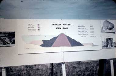
Slide - DAVID MCDONALD COLLECTION: EPPALOCK. CONSTRUCTION, c1960
Eppalock. Construction. Eppalock Project Main Bank. Lake consists of clay fill, Gravel Filter, Rock Filter, Basalt Filter, Stabilizing Fill. Full Supply Level RL637. Crest Length 2000 Feet, Maximum Height 150 Feet, Quantity Clay Fill 550 000 Ton, Quantity Gravel Filler 120000 Ton, Quantity Rock Filler 60 000 Ton, Quantity Basalt Rock Fill 250 000 Ton, Quantity Stabilizing Fill 150 000 Ton, Total Fill 1630 000 Ton. Markings: Eppalock Dam Observation Point Board.Agfacolorcivil engineering, water supply, eppalock -
 Whitehorse Historical Society Inc.
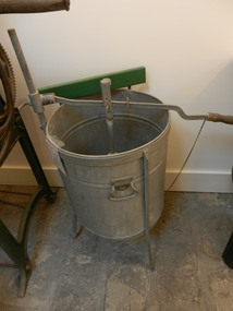
Machine - Washing Machine
Hand operated washing machine - plunger type - a central cone plunger attached to a fulcrum point (adjustable in height) on side with a long arm. Depth of plunger action also adjustable. All mounted on a three leg frame. Container is slightly coned shaped at bottom and has a drain tap at bottom for emptying water. Container can also be lifted off. Provision made for attachment of a wringer (this could be a later modification). Plunger is approx 37cm in diameter and has four 1.5cm holes for water to be forced through. Unit is galvanised steel but frame appears to have been painted with 'Silverfros'.On Side of container - 'The Zwar' VACUUM Washing Machine Patent No 2089/31domestic items, laundering -
 Whitehorse Historical Society Inc.
Equipment - Floor Polisher, c1954
Used by donors for polishing wooden and lino floor in the 1950s and 1960s in their home at 16 McDowall Street, Mitcham.Three brush 'Electrolux' floor Polisher/ Scrubber with polish container and three scrubber brushes, and a remotely operated polish container. It has a 'tee' shape handle which is adjustable in height to polish under tables etc. There is provision for attaching a polish container to the polisher. Flow of polish ie regulated by a chain attached to handle. Handle also has clips for holding the power cord when stored. Body of polisher is squat triangular- shape finished in red and gunmetal grey. There is a heavy rubber skirt surrounding the area where the brushes rotate.|Model B9 Serial CME 6005498 on plate at back.Electrolux Made in Australia - plate at front|Electrolux insignia on front|Plate at back gives power details and serial number.domestic items, cleaning -
 Ballarat Tramway Museum
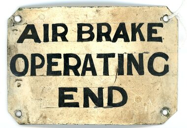
Sign - "AIR BRAKE OPERATING END"
Demonstrates how the SEC used signage to communicate important information to staff.An enameled metal plate sign in an off-white colour, hand painted with black lettering. The sign reads "AIR BRAKE OPERATING END". The sign is curved, and all four corners have been angled. There is a hole in each of the corners to enable attachment to the tram cab. Horizontal lines have been drawn to ensure the even height and spacing of the lettering. The back of the sign has been painted a brass colour, although some of this has flaked off with wear. Two russet coloured stripes, 3mm and 12mm in width have been painted from top to bottom on the reverse. tramways sign, enameled tramway signage, hand-painted tramway sign -
 Bendigo Military Museum
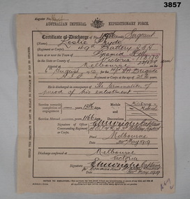
Administrative record - CERTIFICATE OF DISCHARGE WW1, 22.5.1919
Leslie PRYDE "MM". Refer Cat No 914 for his service history and award.A brief description of enlistment, service and discharge on both sides of the document. The document is a fawn colour, thicker than paper but able to be folded in 3 for postage. The front is divided into 3 sections, top being name, rank and serial number, age, enlistment date, unit and birth place. Centre is reason for discharge, service time, awards and decorations. Bottom is signed of by relevant person. The rear is dedicated to the individuals height, complexion, eye and hair colour, age on discharge and trade or calling prior to enlistment, intended place of residence. The person then signs the document. All entries on the form are hand written.On the front at top is a Register No: Unreadable On the rear are 2 numbers; “V/B No 41745 & No 124038”certificate, military history, numismatics, mm -
 Bendigo Historical Society Inc.
Document - MINING REPORTS - WAGES, PRICES & STAMP HEADS
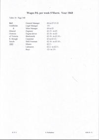
Handwritten notes detailing the wages per week S'hurst year 1868, from boys to the General Manager. Also prices for tools, rope, chain, powder, candles, oil, tallow, quicksilver, leather, cleaning and packing materials, and iron and steel. Also mentioned is the weight of the stampers, their cost, the height they fall, the number of strokes per minute, the number of holes in the gratings, the horse-power to drive each stamper, the quantity of water used per stamp-head in crushing and the quantity of mercury used in the ripples per stamper and the quantity lost per stamp head per week.document, gold, mining reports, wages prices & stamp heads, goldfields & mineral districts of victoria, r brough smyth 1869, sandhurst goldfield 1868 -
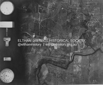
 Eltham District Historical Society Inc
Photograph - Aerial Photograph, Landata, Eltham and Montmorency, Nov. 1931
Centred over present-day Belmont Reserve, Montmorency Historic Aerial Imagery Source: Landata.vic.gov.au Aerial Photo Details: Project No :1931 Project : MALDON PRISON Run : 19 Frame : 3130 Date : 11/1931 Film Type : B/W Camera : F8 Flying Height : 11000 Scale : 18860 Film Number : 60 GDA2020 : 37°43'13"S, 145°07'54"E MGA2020 : 335330, 5823576 (55) Melways : 21 F6 (ed. 42)aerial photo, eltham, neil webster collection, belmont reserve, montmorency, rattray road -
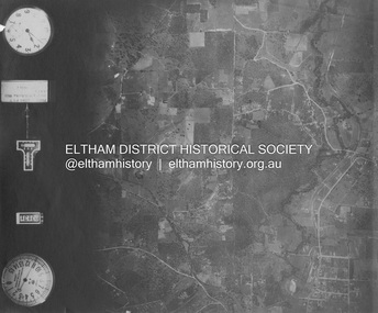
 Eltham District Historical Society Inc
Photograph - Aerial Photograph, Landata, Eltham, Nov. 1931
Centred over Mount Pleasant Road and Kent Hughes Road, Eltham Historic Aerial Imagery Source: Landata.vic.gov.au Aerial Photo Details: Project No :1931 Project : MALDON PRISON Run : 20 Frame : 3137 Date : 11/1931 Film Type : B/W Camera : F8 Flying Height : 11000 Scale : 18860 Film Number : 60 GDA2020 : 37°43'37"S, 145°09'26"E MGA2020 : 337606, 5822892 (55) Melways : 22 A8 (ed. 42) aerial photo, eltham, neil webster collection, kent hughes road, mount pleasant road -
 Vision Australia
Equipment - Object, Book magnifier, 1890-1910
This black wooden antique hinged book magnifier was typical of the elegant way that Victorian age designers combined both practicality and style into the salon. Folded down, this box would sit on a side table until required, whereupon it would expand to allow the user to read items in their hand. A platform designed to hold reading materials would be elevated into position, and the magnifier allowed for three different levels of height. On top of the magnifier are engraved decorations - one of a bow and the other of a globe, telescope and scroll.1 wooden box with fold out top and inset glass magnifier.assistive devices, equipment -
 Ballarat Heritage Services
Photograph - Digital photograph, Nose in Admiralty Arch, London, 19/09/2016
Admiralty Arch is a landmark building in London which incorporates an archway providing road and pedestrian access between The Mall, which extends to the southwest, and Trafalgar Square to the northeast. Admiralty Arch, commissioned by King Edward VII in memory of his mother, Queen Victoria and designed by Aston Webb is now a Grade I listed building. In the past, it served as residence of the First Sea Lord and was used by the Admiralty. Until 2011, the building housed government offices, but in 2012 the government sold a 125-year lease over the building to a property developer (Prime Investors Capital, run by Rafael Serrano) for redevelopment into a luxury hotel, restaurant and apartments. (Wikipedia) On the inside wall of the northernmost arch is a small protrusion the size and shape of a human nose. It was placed there by artist Rick Buckley in 1997 as part of a campaign against the "Big Brother" society. The nose is at a height of about seven feet, and sits at waist height for anyone riding through the arch on a horse. Prior to Buckley being unmasked in 2011 by the London Evening Standard, an urban myth grew that the nose is there in honour of the Duke of Wellington, who was known for having a particularly large nose.(wikipedia)admiralty arch, london, nose -
 Kiewa Valley Historical Society
Projector - 'Pictoral' Bogong State School, 1925 - 1935
As Bogong State School was located in a remote area especially in winter when the weather and therefore the road isolated the school for an indefinite time, the school was provided with up to date equipment with a comprehensive library and educational films that wouldn't disadvantage the students. Educational films covered all subjects and areas of the curriculum. The projector was very modern at the time. The Society for Visual Education Inc was founded in 1919 as a for-profit educational publisher dedicated to the use of new technologies in teaching.This projector was used at the Bogong State School which opened in 1941 for the children of the employees of the State Electricity Commission of Victoria who were working on the Kiewa Hydro Electric Scheme. The school was outstanding as reported by the school inspectors regarding the education of the pupils which was also supported by new and modern equipment. The nearest school was 14 km away over a dirt road that wound around the Victorian mountains and often closed due to bad weather. Bakelite box holding a globe and a small black tin projector on brown rectangular bakelite base with 4 round rubber stands at each corner. It is able to be moved upwards from the front to adjust the height within a cm. The back is a tall irregular box shape with ventilation on 2 sides of the bottom and at the top. There is a brass plaque attached above 1 vent and an electric cord, with switch, below it. Attached at each side of the front of this box is a cylinder fitted horizontally facing the front where the lense is fitted. At right angles above there is another cylinder, hollow, with a rod for the film to be placed. Globe also in Bakelite boxPlaque: Pictorial Projector / Model Q / 120 Volts. 100 Watts / No. 23736 / Manufactured / Society of Visual Education Inc. / Chicago U.S.Aprojector, bogong primary school, education, educational films, visual education, kiewa hydro electric scheme -
 Bendigo Military Museum
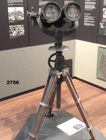
Equipment - JAPANESE ARTILLERY BINOCULARS
These binoculars were originally held in the Headquarters of the Pacific Islands Regiment in New Guinea. In February 1946, Colonel H. T. Allan OBE, MC, ED was presented with the binoculars to bring home as a souvenir. Refer Cat No 2755.4 for his extensive career and awards. During World War 2, they were used by a Japanese Army artillery unit.A tall and heavy set of binoculars comprising the binoculars set and a tripod base with wooden legs. The binoculars are attached to the tripod via a circular metal base plate with a small levelling bubble on the surface. The base plate is marked in degrees from zero to 360. Between each lens tube is an aiming device. The top of the tripod has a winding mechanism for raising and lowering the height of the binoculars. On the right hand side of the binoculars is a marked gauge which allows them to be tilted at different angles of elevation. Each of the eyepieces is able to be adjusted to fit the user's face. A silver metal manufacturer's plate is attached to the top of the binoculars.On the silver manufacturer's plate: Details in Japanese writing.military equipment, military history, herbert trangmar allan, japanese army, binoculars -
 Federation University Historical Collection
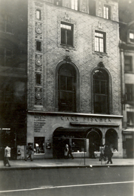
Photograph - Black and White, Carl Fischer Building, New York, 1920s?
Carl Fischer was a major publisher of music. This photograph is part of Frank Wright's collection.Black and white photograph of the lower three floors of an Art Deco style building. On the ground level the arched door has a canvas porticoed entrance and there are three arched windows on the right side and a small square window on the left. The name 'Carl Fischer' is seen above the arches. Above are two second floor double height ornate arched windows and above these are two large rectangular windows. On the left side of these windows is a single column of small windows. Above these floors can be see the start of the rest of the building with more modest windows. People can be seen walking along the pavement. The place is New York.carl fischer, frank wright, new york, sheet music -
 Royal Australian and New Zealand College of Obstetricians & Gynaecologists (RANZCOG)
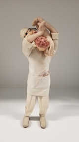
Textile - Felt and linen figurine of an obstetrician holding a baby
Standing figurine of an obstetrician holding a baby. The figurine is made of felt, likely with a wire frame. The obstetrician is wearing full linen surgical attire, with white trousers, surgical gown, and surgical cap. The surgical gown has a large pocket at the front, containing a set or forceps. The obstetrician has black, curly hair, blue eyes and is wearing wire framed glasses. The baby is being held at head height, with ankles being held in the left and and the baby's upper legs being held in the right. The obstetrician's head is bent backwards as if the obstetrician is examining the baby's legs or ankles. The baby has curly pink hair. -
 Kew Historical Society Inc
Map, MMBW, MMBW Plan No.117 Heidelberg & Kew, 1900-1910
The Melbourne and Metropolitan Board of Works (MMBW) was established by an act of the Victorian Parliament in 1890 to prepare for and to implement a sewerage and water reticulation system across what was then inner Melbourne, its surrounding and middle distance suburbs, including Kew. The MMBW was disbanded in 1991.The map collection of the Kew Historical Society has at its core the historic maps assembled and originally stored in the City Engineer's Department of the City of Kew. These include maps in a number of scales. The vast majority of maps were produced by the MMBW in the first two decades of the twentieth century, and are solid working maps, backed by linen for durability. These maps are historically significant to Kew, the City of Boroondara and to the history of the development of state utilities in Victoria. A number of the Kew maps have additional details added by former municipal officers, including the levels reached by various floods. As these were working documents, information was added to them long after the period of their initial production and distribution.Early map of part of the Borough of Kew, created in the early twentieth century, at a scale 160 ft to 1 inch. The map covers what was then the north eastern part of Kew showing the natural landscape and limited development on the south side of the Yarra River. In the Kew section, south of the river, the land is occupied currently by the Greenacres and Kew Golf Clubs. The map shows the extent of urban development by that time and the outlines of the few built structures in the municipality. The height above sea level of all parts of the landscape are indicated numerically in feet. Contour lines and the levels of historic floods were added in ink to the map at a later stage. MELBOURNE AND METROPOLITAN BOARD OF WORKS / PLAN NO. 117 / HEIDELBERG & KEW melbourne & metropolitan board of works, mmbw maps, borough of kew, cartography, mmbw plan no. 117, kew (vic.) -- maps, heidelberg (vic.) -- maps -
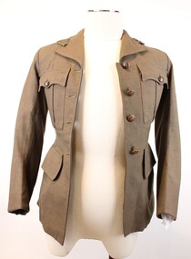
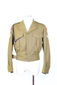 Beechworth RSL Sub-Branch
Uniform - Jacket, Battle Dress, Australian Government Clothing Factory, 1981
Issued as a uniform item post WWII until the late 1980s. It was also used parade dress until its replacement of a newly designed uniform made of polyester. This particular sample belonged to CPL K. Howe 3144504 whist in the Army Reserves 1982 to 2005The khaki battledress was standard uniform issued post world war two and used until the introduction of the polyester uniform in the late 1980s. This uniform belonged to CPL K. Howe, the donor providing good provenance. In conjunction with other items of militaria donated by the Howe family. Item can be to tell a story of multi generations of military service of the Howe familySingle breasted hip-height jacket in khaki fabric, fastened with five buttons down the centre of the chest. Two pleated breast pockets with triangular flaps fastened with two buttons. All buttons plastic and khaki green in colour. Jacket is fastened around the hips with a belt, attached on left hand side and buckled in a rectangular metal buckle on right hand side. Both left and right sleeves bear two patches, a double chevron and red rectangular patch rounded to follow the seam of the shoulder, with embroidered text. Navy lanyard looped around right shoulder, held in place by epaulet and tucked into right side pocket. Red patch reads "ROYAL AUSTRALIAN ENGINEERS" Internal left chest label reads "A.G.C.F./VIC. 1981/[broad arrow symbol]/6405.66.025.6408/SIZE OF CHEST/SIZE 99-102R/MACQUARIE 80/BATCH J/DRY CLEAN ONLY/CREASE UPPER/HALF OF/LAPELS ONLY/No. 3144504 [handwritten]/NAME/CPL K. HOWE [handwritten]"jacket, battledress jacket, battledress jacket khaki, royal engineers -
 Christ Church Anglican Parish of Warrnambool
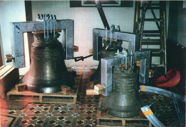
Peal of three German Bells: Memorial to Frederick Stephen STEVENS, Messrs Radler of Hanover, Germany, Late nineteenth century
The bells were sent to the Melbourne Exhibition of 1881. They were awarded first prize. Guaranteed to chime to the sixteenth of a tone. They were purchased by Frederick Perkins Stevens and given to Christ Church Warrnambool as a gift in memory of his son, Frederick Stephen Stevens, who died at his Queensland property in1879.These German bells are the oldest matched peal in Australia.Three bells weighing 9cwt, 5cwt and 3cwt respectively, decorated with angels, medallions and inscriptionsThe largest bell has "Gloria in excelsis Deo: (Glory to God in the highest)"Vivos voco" (I summon the living) and "Motuos plango" (I bewail the dead). The second bell has "In terra pax" (Peace on earth); and the third bell has "In hominibus beneplacitum" (Goodwill towards men) Another inscription in German is "Siehe die Steine Rufen, Ehre sei Gott in de Hohe" (Behold the stones cry, Honour to God in the height)frederick perkins stevens, frederick stephen stevens, melbourne exhibition 1881, radler, warrnambool victoria -
 Kew Historical Society Inc
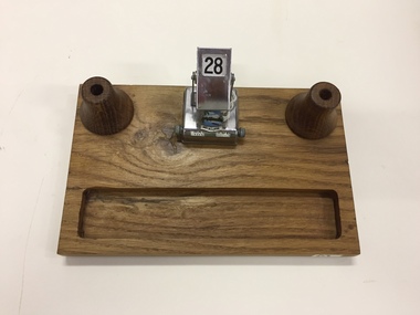
Functional object, Mr Dudley, Pen & Ink Stand, c.1963
Desk set made of wood from St Paul's Cathedral with an added metal and enamel calendar. A history of the item is stuck on the reverse. "St Paul's Cathedral Melbourne. Foundation stone, 1880; Consecrated, 1891; Spires completed, 1931; Exterior length, 317'; Moorhouse Spire, 317 feet in height. The Bells of St Paul's Cathedral were supported on this timber of English oak from 1891 to 1963 when, during the absence of the bells for tuning in Loughborough, England, the timber was replaced with a steel frame. Refer Cathedral Guide Book, page 10, by Rev Godfrey Kircher"handicrafts, desk sets, pen holders, st paul's cathedral - melbourne (vic) -
 Kiewa Valley Historical Society
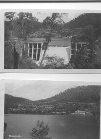
Two black and white photos, Photo downstream view of Junction Dam Wall and photo of Bogong Village and Lake Guy, c1950
Photo No. 1 - Junction Dam wall was commenced in February, 1940 and completed in March 1944. Type - reinforced concrete slab and buttress. Height 25.9m, and crest length 121.9m. Lewis Construction company had the original contract, but was replaced by the State Electricity Commission in 1942. Photo No. 2 - Bogong Village was the first village built to house workers and their families working on the Hydro electric scheme. Construction commenced 1940. The single men's quarters are slightly right of centre on the foreshore. Lake Guy was named after a former resident engineer.Shows the type of terrain where the village is located resulting in the tiered layout that was necessary in order to erect housing.set of 2 black and white photos - Photo No. 1 - downstream view of Junction Dam Wall Photo No. 2 - Lake Guy and Bogong Village. Both are on photographic paperPhoto No. 1 - Upper right hand corner, back of photo, handwritten in ink or biro, Bogong 1950 Photo No. 2 - Left lower corner, front of photo in white, Bogong.bogong village, lake guy, secv -
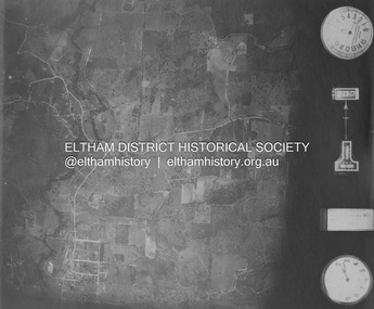
 Eltham District Historical Society Inc
Photograph - Aerial Photograph, Landata, Eltham and Lower Plenty, Nov. 1931
Centred over present-day Rosehill Road and View Road, Lower Plenty Historic Aerial Imagery Source: Landata.vic.gov.au Aerial Photo Details: Project No :1931 Project : MALDON PRISON Run : 19 Frame : 3129 Date : 11/1931 Film Type : B/W Camera : F8 Flying Height : 11000 Scale : 18860 Film Number : 60 GDA2020 : 37°44'16"S, 145°07'40"E MGA2020 : 335039, 5821622 (55) Melways : 21 E11 (ed. 42)aerial photo, eltham, lower plenty, neil webster collection, rosehill road, view road -
 Eltham District Historical Society Inc
Photograph - Aerial Photograph, Landata, Eltham and Eltham North, Nov. 1931
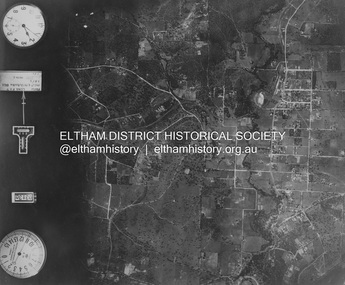
Centred over present-day Opal Court and Manning Road, Eltham North Historic Aerial Imagery Source: Landata.vic.gov.au Aerial Photo Details: Project No :1931 Project : MALDON PRISON Run : 19 Frame : 3131 Date : 11/1931 Film Type : B/W Camera : F8 Flying Height : 11000 Scale : 18860 Film Number : 60 GDA2020 : 37°42'10"S, 145°08'07"E MGA2020 : 335621, 5825531 (55) Melways : 21 G2 (ed. 42)aerial photo, eltham, neil webster collection, eltham north, manning road, opal court -
 Eltham District Historical Society Inc
Photograph - Aerial Photograph, Landata, Eltham and Eltham East, Nov. 1931
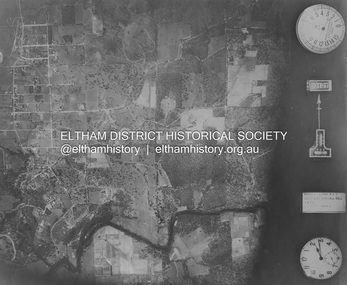
Centred over present-day Beard Street bewteen Park Road and Main Road, Eltham East Historic Aerial Imagery Source: Landata.vic.gov.au Aerial Photo Details: Project No :1931 Project : MALDON PRISON Run : 20 Frame : 3135 Date : 11/1931 Film Type : B/W Camera : F8 Flying Height : 11000 Scale : 18860 Film Number : 60 GDA2020 : 37°42'16"S, 145°09'41"E MGA2020 : 337912, 5825386 (55) Melways : 22 B2 (ed. 42)aerial photo, eltham, neil webster collection, beard street, eltham east, main road, park road -
 Eltham District Historical Society Inc
Photograph - Aerial Photograph, Landata, Eltham, Nov. 1931
Centred over present-day Laleham Court between Arthur Street and Hartland Way, Eltham Historic Aerial Imagery Source: Landata.vic.gov.au Aerial Photo Details: Project No :1931 Project : MALDON PRISON Run : 20 Frame : 3136 Date : 11/1931 Film Type : B/W Camera : F8 Flying Height : 11000 Scale : 18860 Film Number : 60 GDA2020 : 37°42'56"S, 145°09'33"E MGA2020 : 337759, 5824139 (55) Melways : 22 B5 (ed. 42) aerial photo, eltham, neil webster collection, arthur street, hartland way, laleham court -
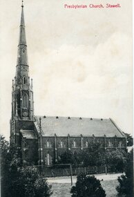 Stawell Historical Society Inc
Photograph, St. Matthew’s Presbyterian Church
St. Matthew’s Presbyterian Church Stawell. Now United Church. This landmark of Stawell was opened on 11th April 1869. The tower and spire, overall height of 148 feet, cost 1352 pounds and was paid for by an early mine owner. In March 1869, a month before the Church was opened, the local paper reported that a large red flag on the top of the Presbyterian Spire meant that the last brick had been laid and the massive gilt ball and cross had been placed in position. The Church has some fine stained-glass windows. Two identical side views of a church with a tall steeple. These photos were taken from the original Post Cards in Album 13, p.41. The photo shows a Tennis Courts in foreground with a picket fence around the church. Presbyterian Church, Stawell written on the front of the post card and June' 09 Stawell written in pencil on the back. Post cards printed in Germany.stawell religion -
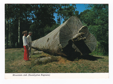 Marysville & District Historical Society
Postcard (item) - Colour postcard, Colorscans (Publishing) Pty Ltd, Mountain Ash (Eucalyptus Regans), Pre 2009
A colour photograph of a felled Mountain Ash tree that was on display in Marysville, Victoria.A colour photograph of a felled Mountain Ash tree that was on display in Marysville, Victoria. This postcard was produced by Colorscans (Publishing) Pty. Ltd. as a souvenir of Marysville.Colorscans C PUBLISHED & PRINTED BY COLORSCANS (PUBLISHING) PTY. LTD. 118 BRIGHTON STREET, RICHMOND 3121 Supa-vu/ cards MARYSVILLE - VICTORIA This Mountain Ash (Eucalyptus/ Regnans) log was felled in 1971/ on Mt. Observation. Total height/ 57.3 metres, age 224 years. Volume/ of this log 1194 super feet suffic-/ ient to frame an average house. Photographed and Distributed by:/ K & H. ELLIS - 35 Old Warburton Road,/ Warburton 3799marysville, mountain ash, eucalyptus regnans, victoria, colorscans publishing, postcard, souvenir -
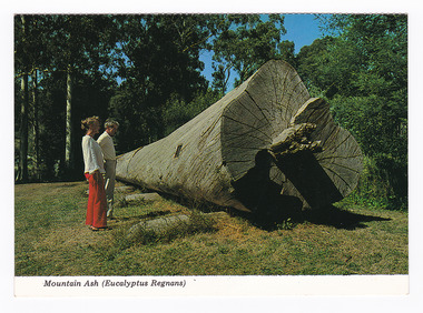 Marysville & District Historical Society
Postcard (item) - Colour postcard, Colorscans (Publishing) Pty Ltd, Mountain Ash (Eucalyptus Regans), Pre 2009
A colour photograph of a felled Mountain Ash tree that was on display in Marysville in Victoria.A colour photograph of a felled Mountain Ash tree that was on display in Marysville in Victoria. This postcard was produced by Colorscans (Publishing) Pty. Ltd. as a souvenir of Marysville.Colorscans C PUBLISHED & PRINTED BY COLORSCANS (PUBLISHING) PTY. LTD. 118 BRIGHTON STREET, RICHMOND 3121 Supa-vu/ cards MARYSVILLE - VICTORIA This Mountain Ash (Eucalyptus/ Regnans) log was felled in 1971/ on Mt. Observation. Total height/ 57.3 metres, age 224 years. Volume/ of this log 1194 super feet suffic-/ ient to frame an average house. Photographed and Distributed by:/ K & H. ELLIS - 35 Old Warburton Road,/ Warburton 3799marysville, mountain ash, eucalyptus regnans, victoria, colorscans publishing, postcard, souvenir -
 National Wool Museum
Textile - Parsons Rolled Oats Bag
These domestic kitchen bags were donated to the National Wool Museum by Lila Gore. Lila donated Children’s Clothing (RGE 8324) to the museum in 2022 and at her time of donating, inquired as to whether the museum would also be interested in these bags she had been collecting. Lila said there was no reason as to why she was saving the bags, other than she liked the art works and thought they were too good to end up in landfill. She had thought perhaps she would make something out of the bags, or perhaps give the bags to a friend to make something. When Lila was donating the Children’s Clothing to the museum, she thought that the National Wool Museum would be the perfect home for the bags. Domestic kitchen bags such as these date from the late 19th century through the mid-20th century. They were used at home, usually by women, containing household items which would not spoil, such as flour, sugar, animal feed, seeds, and other commodities. In modern times a trip to the supermarket is a daily chore, in the past however, these trips happened far less often, with big sacks such as these a large reason why. In the rural US and Canada, Feed sack dresses and Flour sack dresses, were an iconic part of rural life from the 1920s through the Great Depression, World War II, and post-World War II years. Australia also reused these sacks, typically for making wagga style blankets, but re-use for clothing was not unusual.Calico oat bag with colour image and black text. Image shows a full length brown horse with bridle.Front: PARSONS FARM ANIMAL SERIES No.3 \ SUFFOLK \ The Suffolk, often known as the Suffolk Punch, originated in the County of Suffolk, England \ and is noted for its hardiness. From 15 to 16 hands in height. The Suffolk in general is smaller than \ the Clydesdale. The head is rather coarse, with the neck short. The body long deep and wide with \ a round full appearance. The croup is straight and legs short and free from leather. The invariable \ colour is chestnut, varying from light to dark.wagga, flour, oats, bag, calico, lila, gore, depression, war, kitchen -
 Shepparton RSL Sub Branch
Uniform, Dress Jacket, 1943
This jacket belonged to Dorothy May Mortlock (VF518245) who was part of the Australian Womens Army Service (AWAS). Dorothy Mortlock was born in Swan Hill and enlisted with the 3rd AUST AWS REC DEPOT.Khaki-coloured woollen jacket which fastens along the centre via four metal buttons. Two hip-height pockets with external flap; two chest pockets with pleat in centre fastened via a metal button. Fabric belt around waist held in place by two fabric loops on back and fastened through metal buckle and loop. Collar carries two metal rising sun badges on the left and right side. Two epaulettes on either shoulder are held in place by a button and carries a badge reading "AWAS". Colour patch on both left and right side is square, half green and half black. Interior label on base of neck.Label reads "V 579/1943/SIZE/MADE IN/AUSTRALIA/D. MORTLOCK/VF518245". Rising sun badge reads "AUSTRALIAN COMMONWEALTH/MILITARY FORCES." Buttons read "AUSTRALIAN MILITARY FORCES."world war ii, second world war, wwii, women, australian women's army service -
 Bendigo Historical Society Inc.
Photograph - T C WATTS & SON COLLECTION: 62 CARPENTER STREET, BENDIGO, 1930
Black and white photographs (s) mounted on rectangular brown board. House, two storey, brick, roughcast above dado height, upper storey has shingles under windows shingles below front gable. Brick verandah piers with wooden freized upperparts. Two stepped masonry approaches, two event verandahs. Roughcast to lower walls below floor level, lower window with six lights [5 leadlighted] On back of photo ' Phillips, Carpenter Street. £2500 sewered with all furnishing including wireless set but not including sewing machine, piano or organ and £3000 with all furniture'. 2012 photo of house attached to record.bendigo, business, t c watts & son -
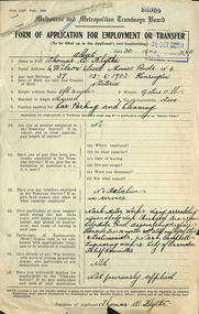 Melbourne Tram Museum
Document - Form/s, Mr. E Westcott, "Form of application for employment or transfer", 30/10/1940 12:00:00 AM
Form - foolscap of a very light blue paper and four quarto ruled sheets attached by staple to a "Form of application for employment or transfer", completed 30/10/1940 and date stamped 31/Oct. 1940" from Thomas A Blythe of Moonee Ponds for the position of "Car Parking and Cleaning". Has space for personal details, address, age, height, marital status, current employment, relatives, details of previous employment, references testimonials, war service. Attached are hand written copies of four testimonials from Nash Motors, Campbell Motor Engineering Works and the City of Essendon Unemployed Relief Committee dated 5-2-1932. No indication as whether he was employed or not.Various hand written notations by the applicant. stamped "86009" in the top right hand corner.trams, tramways, employment forms, personnel, depots, cleaners