Showing 10891 items
matching land
-
 Buninyong & District Historical Society
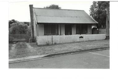
Photograph - Original B/W Photograph, Miner's cottage built on land owned by Thomas Hiscock in Learmonth St west, Buninyong, April 1994
The weatherboard cottage was built in the 1860's on land owned by Thomas Hiscock, the discoverer of gold near Buninyong township.The weatherboard cottage was built in the 1860's on land owned by Thomas Hiscock, the discoverer of gold near Buninyong. It is a good example of a miner's cottage of its era.B/W photo of Miner's cottage, Learmonth St west, Buninyong. Streetscape photo taken in 1993 of a weatherboard building with picket fence.miners cottage, house, building, weatherboard, thomas hiscock, hiscock, buninyong, learmonth st -
 Whitehorse Historical Society Inc.
Legal record - Land Title, Moffatt land, 1905
Certificate of Title recording land owned by Moffatt Family members:Certificate of Title recording land owned by Moffatt Family members: Vol. 2798 Fol. 489 4 acres 2 roods 13 perches, Bakers Road Blackburn to William James Moffatt 25 July 1905 from Arthur Palmer Blake (previously owned by Robert Falconer); with new certificate Vol. 3065 Fol. 941 incl. transfer to Charles Henwood 13 November 1953.Certificate of Title recording land owned by Moffatt Family members: moffatt, william james, blake, arthur palmer, falconer, robert, bakers road blackburn -
 Warrnambool and District Historical Society Inc.
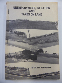
Book, Unemployment, inflation & taxes on land, 1982
This book details the problems caused by the low level of land tax in Victoria. It was written by Dr Les Hemingway who was a fitter and turner who studied medicine at the University of Melbourne and came to Warrnambool in 1958. He replaced Dr Etheridge in a Liebig Street practice. He retired in the mid 1990s. His book on the land tax question was influenced by the writings of the American journalist/philosopher, Henry George. This book is of interest as it was written in 1982 by Les Hemingway, a local Warrnambool doctor who practised in Warrnambool for over 30 years. This is a soft cover book of 152 pages. The cover is buff-coloured with a collage of black and white photographs on the front cover and a summary of the book on the back cover. There is black lettering on the cover and spine. The cover is a little torn and shows evidence of silverfish damage. The book is bound with three metal staples.economic history, history of warrnambool, dr les hemingway -
University of Melbourne, Burnley Campus Archives
Document, Burnley Gardens, 1976
Memo re changes in areas of land granted to Burnleyburnley gardens, land -
 Greensborough Historical Society
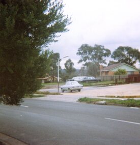
Photograph, Vacant land, Corner Wilson Avenue and Rattray Road Montmorency 1985, 1985_
A photograph of vacant land, Corner Wilson Avenue and Rattray Road Montmorency 1985, taken by Peter Graham, a Shire of Eltham Councillor.1 colour photograph.montmorency, peter graham, rattray road montmorency, wilson avenue montmorency -
 Stawell Historical Society Inc
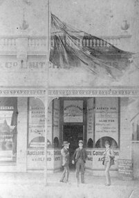
Photograph, Mitchell Bros as Auctioneers of Stock and Land Agents in Main Street Stawell 1890
Business - Mitchell Bros. (Auctioneers Stock and Land Agents 1890) Main Street Stawell opposite Coles/Lyal Eales Store.stawell -
Warrnambool and District Historical Society Inc.
Document (item) - Allansford land purchase document, Land purchase document, 1864
This paper contains details of the purchase of Lot 11 in the Township of Allansford in 1864. The purchaser, Isabella McQueen, was born in Scotland in 1814, married Alexander McQueen in 1850 and with her family migrated to Australia in 1854. After her husband's death in 1860 Isabella purchased the land in Frank Street, Allansford in 1864 and lived in a house there with family members until her death in 1895. She had purchased the land, via an agent, from John Allan who with his brothers were the pioneer European settlers in the Allansford area. John Allan had created the township of Allansford in the mid 1850s by sub-dividing the land he owned there. John Allan moved to the Gippsland area late in 1864. This piece of paper is most significant as it is an original record of an early transaction in the history of Allansford, a town now part of Warrnambool City.Mrs isabella McQueen Bot. of Robert Gregory As agent for J M Allan Esq. Lot no. 11 as marked and described on the Plan of Subdivision of the Township of Allansford. For which I have received the um of five pounds Stg. being the purchase money of same. Robert Gregory 21st October 1864allansford history, john allan, isabella mcqueen -
 Ringwood and District Historical Society
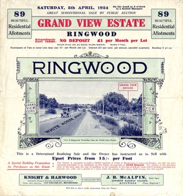
Flyer, Subdivisional Land Auction Sale Brochure, Grand Central Estate, Ringwood, Vic. - 1924
Refer also to Reg. No. 5148 for 1925 auction sale of land also titled Grand View Estate situated further south in Ringwood.Double sided multi-folded page advertising public auction sale on Saturday, 5th April, 1924, of residential allotments highlighting local facilities, services and layout of the estate. Includes panoramic view over the estate and other local photographic images.Subdivision includes Whitehorse Road, Rupert Street, Herbert Street. and Leonard Street. Agents - Knight & Harwood, 315 Collins Street, Melbourne, Phone 10615, 10616 Central, in conjunction with J.B. McAlpin, Opposite Railway Station, Ringwood. Phone Ringwood 7. -
 Federation University Historical Collection
Photograph - Photograph - Black and White, Land Rehabilitation, 09/1991
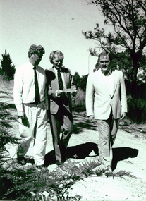
A major funds injection helped to establish the Ballarat University College Centre for Land Rehabilitation. The project was co-ordinated by Dr Leigh SullivanBlack and white photograph showing three men strolling outdoors. The are (left to right) Michael Ransom (Assistant Regional Manager, Department of Conservation and Environment; Professor John Sharpham (Director of Ballarat University College) and Dr Leigh Sullivan (Co-ordinator of the National Soil Conservation Programme).ballarat university college, centre for land rehabilitation, leigh sullivan, john sharpham, michael ransom -
 Greensborough Historical Society
Folder, Black Family Land Titles, 1891o
Collection of seven Certificates of Title for land in present-day Watsonia owned by members of the Black Family, ranging from 1891 to 1939, including transfers to 1967.Looseleaf folderblack family, watsonia -
 Greensborough Historical Society
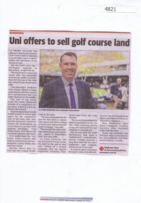
Newspaper Clipping, Diamond Valley Leader, Uni offers to sell Strathallan Golf Course land, 30/08/2017
La Trobe University has offered to sell the Strathallan Golf Course land to Darebin Council after years of speculation over the future of the Bundoora site.News article 1 page, black text, colour image.la trobe university, strathallan golf course, darebin council -
 Ringwood and District Historical Society
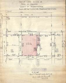
Document, 1926 Land Survey drawing of the area surrounding 1-5 City Road, Ringwood
Drawing on parchmentHand-drawn survey of what is now 1-5 City Road, Ringwood. Drawn by K Arndt, licensed surveyor, 237 Queen Street, Melbourne Tel 5118 on 25 September 1926. The block of land in question was 2 roods, 21 and 8/10 perches in size. The location was between Haig Street in the north, City Road in the south, Wantirna Road in the west and Victoria Road in the east. The Good Shepherd Retirement Village (Lutheran) now occupies the land. The drawing shows a number of existing weatherboard houses, fences and frontage sizes. A number of named roads were defined but no longer exist, these were Duffy Street (to the west), Evans Street (east) and Victoria Street (further east). Ireland Street still exists in the south. -
 Ringwood and District Historical Society
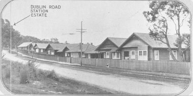
Photograph, Two images of 1924 Dublin Road Station Estate land sale promotional photograph - War of 1914-18 Soldiers homes on Bedford Road
Typed below photograph, "10 modern villas recently erected alongside the estate". Typed below photograph, "Soldiers Homes, Bedford Road. 1924." Catalogue card reads, "Soldiers homes Bedford Road, looking east from outside shops corner Illoura Ave. War of 1914-18 Soldiers Homes. From land sale brochure." -
 Horsham Regional Art Gallery
Sculpture, Barbara HEATH, Land race 1: Apple, Land race 2: Briar, Land race 3: Aloe, 2012
Land race 1: Apple purchased through the Horsham Art Gallery Trust Fund with the assistance of the Horsham Gallery Trustees, 2014. Land race 2: Briar and Land race 3: Aloe both donated through the Australian Government's Cultural Gifts Program by Barbara Heath, 2014. -
RMIT GSBL Justice Smith Collection
Book, Wiseman, H. Dallas, The law relating to the transfer of land : comprising the Transfer of Land Act 1928 (Victoria) and other acts affecting the transfer of land with commentary, notes of Australasian decisions, forms in general use and rulings and practice of the office of titles, 1931
Second editionvictoria. transfer of land act 1928, real property -- victoria, transfer (law) -- victoria, land titles -- registration and transfer -- victoria -
 Victorian Aboriginal Corporation for Languages
Book, Hetti Perkins, Crossing country : the alchemy of Western Arnhem Land art, 2004
Hetti Perkins introduces this collection of reproductions of of Western Arnhem Land bark paintings, rock art, woven fibre art and wooden sculpture that was exhibited by the Art Gallery of NSW in 2004, emphasising the cultural foundations of the Kuninjku artists, their beliefs, artistic conventions and innovations. The book includes interviews with traditional rock and bark artists (including some language), and essays describing the connection of the people to the land, their spiritual beliefs and their art. There are also reproductions of works on paper and woven forms and an essay on the role of women in producing these art forms. An essay by Professor Jon Altmann is entitled "Brokering Kuninjku Art: Artists, Institutions and the Market. A chronolgy details the history of aboriginal art in the area, there are biographies of the artists whose works were included in the exhibition, a list of the works themselves, a glossary of place names, art terms, aboriginal, linguistic and anthropological terms, and a select bibliography. The list of contributors includes, as well as the two mentioned above, Dr Murray Garde, Apolline Kohen, Steven Miller, Cara Pinchbeck and Dr Luke Taylor.Colour photographs -
 Greensborough Historical Society
Document - Folder, Peter Simmenauer, Hobson land, edited by Peter Simmenauer, 2018_07
Robert Hobson purchased 148 acres of land in Crown Portion 17 from the Crown Grantee John Brown in 1877, which was sold to George Knowles Parker and John Howard Aylwin in 1887. A major purchaser of this land east of the Greensborough Road was Mary Baird in 1929. Although Baird died in 1944, sales from her estate continued until 1956. The folder Includes relevant Old Law documents and Certificates of Title, as well as a list of sales of LP11599 allotments.Loose-leaf folder of documents - lists and plansrobert hobson, mary baird, hobson street greensborough -
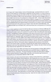
 Wonga Park Community Cottage History Group
Photograph (sub-item) - Map of original land settlement in 1890’s – known as ‘the Eight Hour Pioneer village Settlememt’, the square mile around the Wonga Park Store today (red square)
Map of original land settlement in 1890’s – known as ‘the Eight Hour Pioneer village Settlememt’, the square mile around the Wonga Park Store today (red square). -
 Clunes Museum
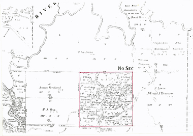
Photograph
PHOTO OF FIRST PLANE TO LAND IN CLUNES, NEAR THE OLD HOSPITAL.PHOTOGRAPH / COPY OF AEROPLANE WITH CROWD OF PEOPLE. PHOTOGRAPH OF FIRST PLANE TO LAND IN CLUNESHANDWRITTEN ON BACK - "ONE OF THE FIRST AEROPLANES TO LAND IN CLUNES (IF NOT THE FIRST). LANDED IN PADDOCK ALONGSIDE CLUNES HOSPITAL ON CRESWICK ROAD ABOUT 1920. NOTE NURSE IN UNIFORM."local history, photography, photographs, events and celebrations, first plane to land in clunes -
 Mont De Lancey
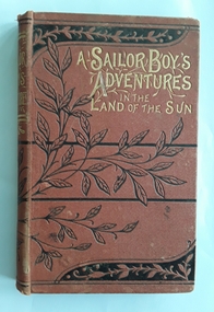
Book, James Nunn, A Sailor Boy's Adventures in the Land of the Sun, c1900's
Set in the early 19th century days of sailing and shipwrecks with a young boy as the main protaganist telling of his many adventures in far away lands. It has very strong religious themes.A small tan hardcover children's fiction book - A Sailor Boy's Adventure in the Land of the Sun by James Nunn who was the author of The Realm of the Ice King and Saved from the Wreck. The front cover has the title printed in gold lettering at the top with bands of black lines and leaf outlines. The spine too has the title in gold lettering with black leaves. The frontispiece in black and white depicts a lion attacking a man with hunters in the background. There are a few similar black and white illustrations throughout the book.128pp.fictionSet in the early 19th century days of sailing and shipwrecks with a young boy as the main protaganist telling of his many adventures in far away lands. It has very strong religious themes.religious stories, religious books, religious fiction, adventure stories, adventure fiction, stories for boys -
 National Vietnam Veterans Museum (NVVM)
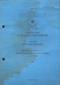
Booklet, Australian Army, Australian Army: Manual of Land Warfare, Part Two, Infantry Training volume 4 Pamphlet No 3: the Sub Machine Gun 9 mm F1 (All Corps) 1983:, 1983
A blue coloured cardboard cover which has signs of water damage on it and it is slightly buckled. Under the Australian Army Insignia is the niformation in black ink. Top right hand corner reads 7610-66-107-6806. There are two punch holes down the left hand side.There is a name in blue ink which I think reads Sgt Raynant, D. F. The description of the cover is different to the one inside of the cover which reads: Australian Army: Manual of Land Warfare. Part Two Corps Doctrine Infantry Training Volume 4 Infantry Small Arms. Pamphlet No 3 The Sub Machine Gun 0 mm F1 (All Corps) 1983australia - armed forces - service manuals, land warfare, infantry training, sub machine gun 9mm f1, corps doctrine, infantry small arms -
 St Kilda Historical Society
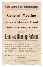
Ephemera - Flyer, Land and Housing Reform, c1920-1940
For public meeting of Elwood and South St Kilda Progress Association on land and housing reform. The full date is not given. The Association met on Tuesday nights in the Methodist School Room, Elwood in the early - mid 20th century.White paper, discoloured by age,, printed one side in blackelwood and south st kilda progress association, housing reform -
 Ringwood and District Historical Society
Flyer, Subdivisional Land Auction Sale Brochure, Grand Central Estate, Ringwood, Vic. - 1925
Douglas Street shown in the estate plan did not eventuate, but was developed as a public reserve. Refer also to Reg. No. 5149 for 1924 auction sale of land also titled Grand View Estate situated further north in Ringwood.Double sided multi-folded page advertising public auction sale on Saturday, 31st October, 1925, of residential allotments highlighting local facilities, services and layout of the estate. Includes panoramic view of Ringwood and other local photographic images.Subdivision includes Great Ryrie Street, Heathmont Road, Douglas Street, Garden Street, and Bellevue Avenue. Agents - Knight & Harwood, 315 Collins Street, Melbourne, Phone 10615, 10616 Central, in conjunction with J.B. McAlpin, Opposite Railway Station, Ringwood. Phone Ringwood 7. -
Ringwood and District Historical Society
Document, Notes of Heathmont History extracted from Place of Many Eagles (Russ Haines c2006), plus History of Land on which Heathmont East Primary School Built (Mervyn Chivers 1985)
A4 document "Notes on Heathmont" in two parts: - Heathmonth History notes extracted by Russ Haines from Place of Many Eagles c2006 - Taxt of talk "A History of the Land on which Heathmont East Primary School is Built" by Mervyn Chivers, 1985 Also brief Notes: - Heathmont Progress League 1926 - Deplorable state of Canterbury Rd July 1928 - Letter from Ada Marden 16th May 1973 pdf Version loaded to VC. Original Word Document help in RDHS Archives -
 Ringwood and District Historical Society
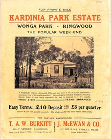
Flyer, Land Sale Brochure, Kardinia Park Estate, North Ringwood, Vic. - circa 1948
Folded buff-coloured land sale advertisement for Kardinia Park Estate in Warranwood area of North Ringwood, including terms of sale, area map, layout plan of the estate, and summary of local facilities and services. Front page features photograph of a man and dog in front of a house captioned as Lot 1 on four acres shown on the estate layout as cnr of Brysons Road and Range View Parade (later Omeo Parade). Second page includes bushland swimming pool photograph and promotional information for prospective buyers.Subdivision includes Kardinia Crescent, Wonga Road, Brysons Road, Range View Parade (later Omeo Parade), Motor Coach Road (later Wonga Park Road, then Warranwood Road). (Agent/s) T.A.W. Burkitt, Main Street, Ringwood, Phone (9 to 6) Ringwood 242, Evenings, Ringwood 157, and J. McEwan & Co, 317 Collins Street, Melbourne, Phone 6750 Central. -
 Eltham District Historical Society Inc
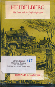
Book, Melbourne University Press, Heidelberg: The Land and its People 1838-1900 by Donald S. Garden, 1972
Although Heidelberg was one of the first parts of the Port Phillip District to be settled, and became important and prestigious in the early years of the colony, its history has been largely neglected. The beauty and fertility of the land and its proximity to Melbourne quickly resulted in the establishment in the 1830s and 40s of large estates by wealthy gentlemen. A romantic spot, Heidelberg became popular with picnickers and later attracted an artists' colony. The character of the area then gradually changed as a distinct village community emerged, and market gardens began to flourish. Unlike some of the suburbs closer to Melbourne, Heidelberg eventually wilted under economic pressures from which it did not fully recover until the turn of the century. This book allows us within the larger contect of the colony's fortunes and misfortunes, the struggle of Heidelberg the suburb to be born " - flyleaf. Contents: First land sales and subdivisions, gentlemen of Heidelberg and their estates and activities, infant rural community. golden fifties, decline and backwater, railway and land boom, a maturing community , the depression of the nineties. This book was the first to focus on the area of Heidelberg and its context within the Port Phillip District and remains significant as a key secondary source for describing the history of the area. It is relevant to the contextual history of its neighbour the former Shire of Eltham and Shire of Nillumbik.Hardback. Includes illustrations and index, 219 p.ISBN 0522840191port phillip district, ivanhoe, heidelberg, charles wingrove -
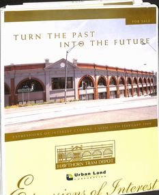 Melbourne Tram Museum
Document - Folder with papers, Urban Land corporation, "Hawthorn Tram Depot - Expressions of Interest Documentation", late 1998
White two spring clip folder with papers, titled "Hawthorn Tram Depot - Expressions of Interest Documentation", sub-titled "Turn the Past into the Future" Has a photo of Hawthorn Tram depot and an image on the front cover. Closing date 17/2/1999, prepared by the Urban Land Corporation with the assistance of VicTrack. Approx 110 pages with supplementary papers in the end covers. Contains a table of contents, checklist, EOI Process, Development Brief, Site conditions. Gives details of the heritage registration, site plans, building plans, property title and detailed room condition and use of the ground floor. Supplementary papers include the marketing brochure, letters and a detail feature and level survey by Bosco Johnson surveyors, 30-9-1998.trams, tramways, htt, hawthorn tram depot, sale of land, property -
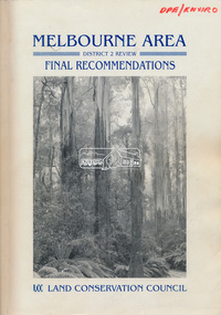 Eltham District Historical Society Inc
Book, Land Conservation Council, Melbourne Area, District 2 Review: Final Recommendations, 1994
Notices showing the boundary of the area of the review and advising that an investigation was to be carried out were published in the Victoria Government Gazette and in local and other Victorian newspapers in May 1987. A descriptive resources report was published in August 1991. Council received 1,425 submissions and letters following publication of the descriptive report. The Council considered these submissions and published proposed recommendations in April 1993. A further 1,993 submissions were received in response to the proposed recommendations. The Council published its final recommendations in July 1994. A change to legislation in 1989 enabled the LCC to make recommendations for public land within a ‘town’, though cities and rural cities remained excluded from the definition of public land. Timber resources and water quality and yield from timbered catchment areas remained significant issues in Melbourne’s catchments. Recommendations for the Yarra Ranges National Park were based around the closed Melbourne water catchments and adjoining state forest. A recommended Phillip Island State Park based around the penguin reserve was ultimately implemented as the Phillip Island Nature Park.Shire of Nillumbik DPE/Enviro -
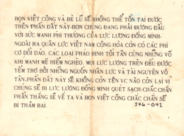 National Vietnam Veterans Museum (NVVM)
Pamphlet, Bon Viet Cong Va Be Lu Se Khong the Ton Tai Duoc Tren Phan Dat Nay - The Viet Cong and their gang will bot be able to survive in this land
Bon Viet Cong Va Be Lu Se Khong the Ton Tai Duoc Tren Phan Dat Nay - The Viet Cong and their gang will bot be able to survive in this land. On the reverse there is a sketch of a VC on a road facing GVN soldiers, aircraft and armour.On the front reads:Bon Viet Cong Va Be Lu Se Khong the Ton Tai Duoc Tren Phan Dat Nay with the details under the heading in Vietnamese. On the reverse side there is a sketch of villager facing GVN Soldiers, Aircraft and Armour. With writing on back.pamphlet, psycological warfare, propaganda, nva/vc, viet cong, 7th battalion, 1st battalion, terry michael collie, 2790361, the royal australian regiment, gvn soldiers -
Clunes Museum
Document - LAND PURCHASE AGREEMENT, 1862
SIGNED IN MELBOURNE 29TH MARCH 1862 BY SIR HENRY BARKLEY GOVERNOR-IN-CHIEF OF THE COLONY OF VICTORIASALE OF CROWN LAND IN VICTORIA 1862TO ABEL GRENFELL OF CRESWICK. LAND SITUATED IN ALLIANCE STREET, CLUNES.local history, document, land purchase, government, colonial government