Showing 11577 items matching " map"
-
 Charlton RSL Sub Branch
Map - Framed map of Bougainville campaign, Framed campaign map of Bougainville campaign November 1944 to June 1945, showing movements of Brigades and actions
Glass framed map of Bougainville Campaign26th Infantry Battallion -
Stawell Historical Society Inc
Map, Borough of Stawell Parish of Stawell and Illawarra 10/06/1903, 10/06/1903
Department of Lands and Survey Map of Stawell with marked roads, allotments, physical landmarks. Found in Storage at ANZ Bank when the old archive was being cleaned out. Also shows Surveyed but unused roads. Showed where customers lived in StawellPholtolithograph Map - Paper on canvas backingBorough of Stawell. Parish of Stawell and Illawarra. County of Borong. Scale 8 Chains to 1 Inch. Scale 16 Chains to 1 Inch. Red Ink Writing, Purple and Blue.town -
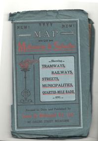 Melbourne Tram Museum
Map, Sands McDougall, Map of Melbourne and Suburbs showing Tramways, Railways, Streets, postal districts, Quarter-Mile Radii etc", c1922
Shows railways, cable and electric tram lines c1922. One of a number of maps produced by Sands McDougall of Collins St. Includes the Zoo horse tram lines. See acquisition and Research note by Duncan McAuslan. See items 2885, 6573, amd 6917 for other editions. On inside cover has current postal rates (including a war surcharge) and places worth visiting and on the rear cover, is an advertisement for Imperial ink.Yields information about Melbourne c1922 and its public transport lines. Produced by Sands and McDougall Pty Ltd of Collins St Melbourne. Folded sheet of paper 6 sections wide x 6 sections or folds deep contained within a green paper cover titled "Map of Melbourne and Suburbs showing Tramways, Railways, Streets, postal districts, Quarter-Mile Radii etc", showing both cable and electric tramways. maps, melbourne, cable trams, tramways, railways, horse trams, vr trams, sands mcdougall, zoo horse tramway, mmtb -
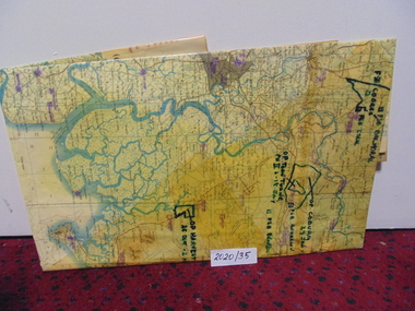 National Vietnam Veterans Museum (NVVM)
Map
A large laminated coloured map of Joint Operations Graphic (ground), Vietnam. there are specific information highlighted in pen.3rar, mcphail collection, map -
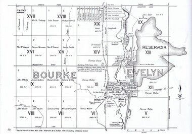 Greensborough Historical Society
Map, Dianne Edwards, Part of Parish of Yan Yean 1878, 1978
Map includes Crown Portions V - XVII, showing Yan Yean Reservoir, Melbourne-Whittlesea Railway route, names of landowners, roads and various other features west of Greensborough Road. Redrawn by A. R. Blair in 1978.1 p. black and white photocopy of mapyan yean reservoir, yan yean -
 Federation University Historical Collection
Map, Ballaarat Gold Field, 1861, 21/10/1861
A party of surveyors camped by Yuille's Swamp (later Lake Wendouree) and surveyed the countryside for a map to be produced by the Geological Survey of Victoria. In November 2004 the Central Highlands Regional Library presented a special edition of 200 copies of the 1861 map reproduced from a copy in their collection. Original geological map of Ballarat showing property, waterways, mines, churches, schools, water races, and garden reserves. It was compiled and drawn from the surveys of Mining Surveyors Davidson, Fitzpatrick and Cowan.Compiled & Drawn from the Survey of Mining Surveyors Davidson, Fitzpatrick and Cowan & the Plans in the Surveyor General's Office by J. Brahe, 21st October 1861. R. Brough Smyth, Secretary for Mines. The Honourable J.B. Humffray, M.L.A. Commr of Mines.ballarat, map, davidson, robert brough-smyth, fitzpatrick, cowan, yuille's swamp, public garden reserve, manure depot, black hill, ballarat east, old post office hill, pennyweight hill, claytons hill, golden point, mining, railway, cricket ground, swamp creek, cemetery, sludge reserve, bakery hill, gaelic church, juvenile reformatory, orphanage, specimen hill, eureka lead, cattle yard hill, dalton's flat, chinese village, poverty hill, railway reserve, little bendigo diggings, pound reserve, allied armies, flour mill, agricultural reserve, marsh, survey reserve, survey corps, white flat, yarrowee, yarrowee creek, brache, j. brache, survey, ballaarat gold field 1861 -
 Federation University Historical Collection
Map, Ballarat, 1936, 06/1936
Map of Ballarat and surrounds, including Lake Learmonth, Snake Valley, Linton, Newton, Durham Lead, Sebastopol, Lake Wendouree, Winter Swamo. It was surveyed in 1933.ballarat, map -
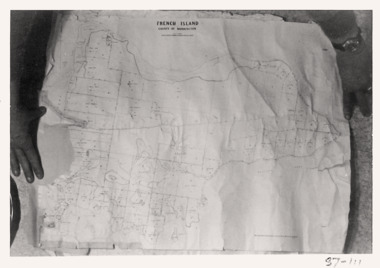 Queenscliffe Maritime Museum
Map - French Island, County of Mornington, French Island map photographs x 2, c1987
Islands off Victorian coastFrench Island mapFrench Island map photographs x 2Reverse " Nil "french island -
Stawell Historical Society Inc
Map, Tourist Map of Grampians/Halls Gap and Surrounds, 1928
Tourist Map of Grampians/Halls Gap and Surroundsstawell, tourism -
Stawell Historical Society Inc
Map, Land Map of Victoria 1898, Supplement to "The Leader", 1898
Land Map of Victoria 1898, Supplement to "The Leader"stawell -
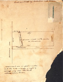 Ringwood and District Historical Society
Map, Hand-drawn map of block of land on Heatherdale Road and Palmerston Road, Ringwood, Vic. (Undated)
One of three unrelated maps on cardboard backing.Handwritten notations - Land purchased by Goldstone and Cooper; 14 acres, 1 rood and 28-8/10 perches or thereabouts; Creation of easement to S.E.C. -
Stawell Historical Society Inc
Map, Topographic Map Callawadda South
Topographic Map 1:25000 Coloured 1990Callawadda South 7424-2-Smapping -
Stawell Historical Society Inc
Map, Topographic Map Ararat North
Topographic Map 1:25000 Coloured 1990Ararat North 7423-2-Nmapping -
Stawell Historical Society Inc
Map, Topographic Map Stawell North
Topographic Map 1:25000 Coloured 1990Stawell North 7423-1-Nmapping -
Stawell Historical Society Inc
Map, Topographic Map Glenorchy North
Topographic Map 1:25000 Coloured 1990Glenorchy North 7424-3-Nmapping -
Stawell Historical Society Inc
Map, Topographic Map Stawell South
Topographic Map 1:25000 Coloured 1990Stawell South 7423-1-Smapping -
Stawell Historical Society Inc
Map, Victorian Topographic Map Glenorchy
Topographic Map 1:25000 Coloured 1985Glenorchy 7424-3-2 Zone 54 VicMapmapping -
Stawell Historical Society Inc
Map, Victorian Topographic Map Bellellen
Topographic Map 1:25000 Coloured 1985Bellellen 7423-4-2 Zone 54 VicMapmapping -
Stawell Historical Society Inc
Map, Victorian Topographic Map Fyans Creek
Topographic Map 1:25000 Coloured 1985Fyans Creek 7423-4-4 Zone 54 VicMapmapping -
Stawell Historical Society Inc
Map, Victorian Topographic Map Ledcourt
Topographic Map 1:25000 Coloured 1985Ledcourt 7424-3-3 Zone 54 VicMapmapping -
Stawell Historical Society Inc
Map, Victorian Topographic Map Barton
Topographic Map 1:25000 Coloured 1985Barton 7423-3-1 Zone 54 VicMapmapping -
Stawell Historical Society Inc
Map, Victorian Topographic Map Illawarra
Topographic Map 1:25000 Coloured 1978Illawarra 7423-4-1mapping -
Stawell Historical Society Inc
Map, Victorian Topographic Map Rupanyup
Topographic Map 1:100000 Coloured 1976Rupanyup 7424mapping -
Stawell Historical Society Inc
Map, Victorian Topographic Map Ararat
Topographic Map 1:100000 Coloured 1966Ararat 7423mapping -
University of Melbourne, Burnley Campus Archives
Plan - Photocopy, Contour Map 1891, 1891
Photocopy of plan showing contour lines from Yarra River. Shows Pavilion and Principal's Residence but not much of the garden design. From Central Plan Office Dept. of Natural Resources."Contour map 1891" written in biroyarra river, pavilion, burnley horticultural college, burnley gardens -
 Bayside Gallery - Bayside City Council Art & Heritage Collection
Map, Department of Crown Lands and Survey et al, Moorabbin, County of Bourke, Government Roads, 1920
The cadastral map of the Parish of Moorabbin in Victoria (L.6104) shows parish boundaries and land ownership 1920 when Sandringham was a Town. The government roads have been coloured in red pencil.moorabbin, county of bourke, map, plan, land subdivision, land titles, foreshores, hampton, beaumaris, highett, cheltenham, department of lands and survey, land owners, cartographic material, brighton, sandringham, town of sandringham, government roads -
 Federation University Historical Collection
Map, Wendouree (Alfredton and Ballarat North) Retail and Business Guide, 2005, 10/2005
Wendouree, Alfredton and Ballarat North Retail and business guide mapmap, guide, wendouree, alfredton, ballarat north -
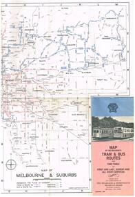 Melbourne Tram Museum
Map, Melbourne & Metropolitan Tramways Board (MMTB), "Map of Melbourne's Tram and Bus Routes" - January 1967, Jan. 1967
Fold out map (12 sections), coloured of Melbourne's Tram and Bus routes, route numbers, rail lines, and location of major places of interest. On rear index to routes, 1st and last services, time of Sunday am services, list of suburbs, how to get there, MMTB Offices and depots and timetable list of all-night buses services.. Dated January 1967. Two copies held. 3rd copy added 28/5/15trams, tramways, melbourne, map, tram & bus services, all night services, route numbers, mmtb -
 Greensborough Historical Society
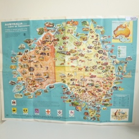
Map, International Harvester, Australia. Land of tomorrow, 1965_
This 1960s map of Australia shows areas of economic development at that time.Colour map of Australiaaustralia economic development, international harvester -
 Creswick Campus Historical Collection - University of Melbourne
Map, Creswick, 1943
Dept of Lands and Survey map of Creswick and county of Talbot. 2 linen backed sheets rolled into white cardboard cylinderMaps