Showing 420 items
matching city planning -- history
-
 Kew Historical Society Inc
Map, MMBW, MMBW Plan No.117 Heidelberg & Kew, 1900-1910
The Melbourne and Metropolitan Board of Works (MMBW) was established by an act of the Victorian Parliament in 1890 to prepare for and to implement a sewerage and water reticulation system across what was then inner Melbourne, its surrounding and middle distance suburbs, including Kew. The MMBW was disbanded in 1991.The map collection of the Kew Historical Society has at its core the historic maps assembled and originally stored in the City Engineer's Department of the City of Kew. These include maps in a number of scales. The vast majority of maps were produced by the MMBW in the first two decades of the twentieth century, and are solid working maps, backed by linen for durability. These maps are historically significant to Kew, the City of Boroondara and to the history of the development of state utilities in Victoria. A number of the Kew maps have additional details added by former municipal officers, including the levels reached by various floods. As these were working documents, information was added to them long after the period of their initial production and distribution.Early map of part of the Borough of Kew, created in the early twentieth century, at a scale 160 ft to 1 inch. The map covers what was then the north eastern part of Kew showing the natural landscape and limited development on the south side of the Yarra River. In the Kew section, south of the river, the land is occupied currently by the Greenacres and Kew Golf Clubs. The map shows the extent of urban development by that time and the outlines of the few built structures in the municipality. The height above sea level of all parts of the landscape are indicated numerically in feet. Contour lines and the levels of historic floods were added in ink to the map at a later stage. MELBOURNE AND METROPOLITAN BOARD OF WORKS / PLAN NO. 117 / HEIDELBERG & KEW melbourne & metropolitan board of works, mmbw maps, borough of kew, cartography, mmbw plan no. 117, kew (vic.) -- maps, heidelberg (vic.) -- maps -
 Kew Historical Society Inc
Map, MMBW, River Yarra Beautification Schemes, c.1913
The Melbourne and Metropolitan Board of Works (MMBW) was established by an act of the Victorian Parliament in 1890 to prepare for and to implement a sewerage and water reticulation system across what was then inner Melbourne, its surrounding and middle distance suburbs, including Kew. The MMBW was disbanded in 1991.The map collection of the Kew Historical Society has at its core the historic maps assembled and originally stored in the City Engineer's Department of the City of Kew. These include maps in a number of scales. The vast majority of maps were produced by the MMBW in the first two decades of the twentieth century, and are solid working maps, backed by linen for durability. These maps are historically significant to Kew, the City of Boroondara and to the history of the development of state utilities in Victoria. A number of the Kew maps have additional details added by former municipal officers, including the levels reached by various floods. As these were working documents, information was added to them long after the period of their initial production and distribution.Map of the City of Kew showing part of the River Yarra Beautification Schemes. The map shows development to date and the flood levels reached in 1923 and 1924. This map may have been adapted from an earlier map, as most development in central Kew and Studley Park had occurred by this date yet numerous streets are not represented. Public buildings and institutions are clearly represented and named on the map as are significant public transport infrastructure (eg the Outer Circle railway).MELBOURNE AND METROPOLITAN BOARD OF WORKS / RIVER YARRA BEAUTIFICATION SCHEMES / SCHEME / SCALE 10 CHAINS TO AN INCHmelbourne & metropolitan board of works, mmbw maps, mmbw plans, city of kew, flood levels -- kew (vic.), cartography -
 Kew Historical Society Inc
Archive (series) - Subject File, McDonalds (Fast Food Restaurant)
Kew Historical SocietySince its foundation in 1958, members of the Kew Historical Society have been compiling and storing information about subjects relating to the history of Kew and its environs, of which this file is an example. Arranged by Secondary Values (value of records to users)Subject file created by researchers of the Kew Historical Society containing information about the McDonald's fast food franchise in High Street, Kew. The file contains a number of primary and secondary sources including newspaper cuttings, planning objections, correspondence between KHS, the City of Kew, the Administrative Appeals Tribunal, and the Department of Conservation and Natural Resources etc. The file also includes copies of the plans for the proposed restaurant. mcdonalds fast food franchises, mcdonalds restaurant -- kew (vic.), administrative affairs tribunalmcdonalds fast food franchises, mcdonalds restaurant -- kew (vic.), administrative affairs tribunal -
Kew Historical Society Inc
Book, Australian Council of National Trusts, Historic Houses, 1982
Originally published in 2 separate v.: Historic public buildings of Australia; and, Historic houses of Australia. North Melbourne : Cassell Australia, 1971 and 1974.Canberra City : Australian Council of National Trusts, 1982, c1974 604 p. : ill. (some col.), plans ; 32 cm. non-fictionOriginally published in 2 separate v.: Historic public buildings of Australia; and, Historic houses of Australia. North Melbourne : Cassell Australia, 1971 and 1974.houses of historical importance --australia, historic buildings -- australia. -
 Glen Eira City Council History and Heritage Collection
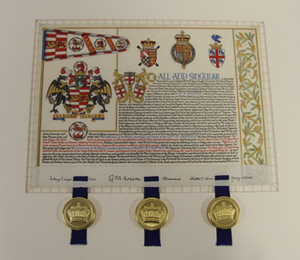
Letters Patent, Letters Patent for the Grant of Arms to the City of Caulfield presented on 1st May, 1977, 01/05/1977
Glen Eira has a long history of association with various heraldic forms. From its early years the municipality of Caulfield had used the armorial bearings of the Caulfield Family (the Charlemonts of Castle Caulfield) to represent the roads board and later the town and city. In 1969 Caulfield City Council began planning to apply for an official coat of arms for the City. In 1974 Horace Hall, a Balwyn North resident and member of the Heraldry Society in London advised Council that the current usage was illegal, and that the Houston family, current owners of the Caulfield Arms could take legal action against Council for 'usurping their arms'. Mr Hall was commissioned to develop new heraldry for the City, and in conjunction with J. P. Brooke Little at the College of Arms, London, he prepared an acceptable design for Caulfield's Coat of Arms. The Council paid an additional sum to have a standard painted on the Letters Patent and the municipality's new coat of arms was drawn up in June 1975. The Coat of Arms retains a number of heraldic elements from the original Caulfield family insignia, including the dragons, the colours and the elements of the shield. The newly registered coat of arms and Letters Patent document for the granting of arms was presented at a civic service to mark the granting of armorial ensigns and the city banner to the City of Caulfield on the 1st May 1977. Significant elements of the coat of arms granted by these Letters Patent are as follows: The motto 'Labore Vinces' translates to 'By our labours we will conquer'. The helmet represents the rank of the owner. Public authorities are granted an esquire's helmet. The brickwork on the crest is a recognised emblem of local government. The Letters Patent also display a banner and a badge, both official symbols of the City of Caulfield. The badge, which is displayed on the banner as well as on its own, features a bridled horse. This represents the importance of racing, the Caulfield racecourse and the Caulfield cup to the municipality. These letters patent officially proclaim the granting of the coat of arms to the City of Caulfield. They are highly significant to the City of Glen Eira as they are the primary document that signifies the official and ceremonial heraldic powers of the Coat of Arms of the City of Caulfield. Mounted Letters Patent illuminated document for the Grant of Arms to the City of Caulfield presented on 1st May, 1977. Hand written and hand painted on cream coloured parchment using different coloured inks, mainly black, blue, red and gouache and gold paint. The bottom edge is folded up over itself approx. 45mm revealing the flesh side of the parchment, which displays black ink signatures and three sets of two horizontal slits that hold three blue ribbon. The ribbons support three wax seals in round, gold coloured metal cases held by the wax through slots in the casing. Although covered by the cap top, each wax seal within displays a different flag emblem with a crown on top, surrounded by a ring of text (difficult to read), noted when the cases were opened during conservation treatment. See attached transcription.arms, symbol, heraldry, glen eira, council, caulfield -
 Glen Eira City Council History and Heritage Collection
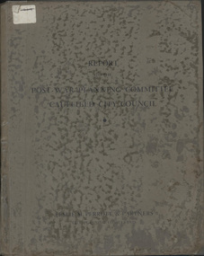
Book, "Report to the Post War Planning Committee, Caulfield City Council"
The Post War Planning Report was prepared by Leslie M. Perrott & Partners: (City Planning Consultants) and according to the report, it was submitted to the Council of the Municipality of Caulfield through its Special Committee on Post War Planning. The report has no evident date however the introduction text suggests that it was prepared before the end of World War II. The report is the only known extant copy and therefore considered rare. Bound report with grey cover titled: "Report to the Post War Planning Committee Caulfield City Council". Interior pages include x83 pages typed text printed on blue print paper; x3 pages copies of black and white photographs; 10 blueprint plans. 86 pages consistent in size with book cover, 10 x blueprint plans varying dimensions, folded and bound within the report. Printed on white sticker on spine of book "LH 994. 51" and on first page inside "CAULFIELD LIBRARY SERVICE REFERENCE BOOK" and on the verso of this page, another stamp with CAULFIELD LIBRARY SERVICE and LH REF 12/7 hand written in black ink and a 14 digit reference number below this. On the back of the last plan in the book, there is a blue stamp with "REFERENCE BOOK TO BE USED IN THE LIBRARY ONLY". Below this is a black and white barcode with a black line through it and a round, blue sticker beside it. -
 Glen Eira City Council History and Heritage Collection
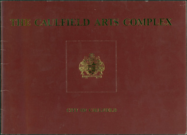
Document - Booklet, "THE CAULFIELD ARTS COMPLEX / CITY OF CAULFIELD", After 1987
Considered to be of historical and social significance. Provides information on the development of the current Town Hall Auditorium and the Glen Eira Gallery.1 x Maroon coloured booklet with gold lettering on cover published by the City of Caulfield. Inside are 14 paper pages with colour concept drawings of the proposed Caulfield Arts Complex, Concept Plans and printed text. Dated May 1987 in the opening page with an Introduction by the Mayor of Caulfield, Cr Jack Campbell. -
 Glen Eira City Council History and Heritage Collection
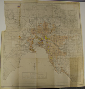
Map - Map, zoning, Metropolitan Town Planning Commission, "DISTRIBUTION AND USE OF EXISTING PROPERTY. MAP NO. 6.", 1929
The map titled: “Distribution and use of Existing property map No. 6” (Metropolitan Town Planning Commission Melbourne and Suburbs) is of historical significance. It is listed on page 168 of Chapter 4 the Zoning section of the "Plan of General Development Melbourne Report of the Metropolitan Town Planning Commission 1929" - Melbourne's first strategic plan. Map No. 6 is mentioned throughout Chapter 4 of the 1929 Report. It states on page 156 that this Map was created to graphically illustrate the data collected by the Planning Commission. The Map illustrates the general distribution of uses of existing property throughout the metropolitan area. The coloured sections show the areas which were developed or were in the process of development in 1929. The colours indicate the distribution of uses in the developed areas. The pink coloured areas, which include Caulfield, were almost completely residential.1929, metropolitan town planning commission, melbourne, suburbs -
 Surrey Hills Historical Society Collection
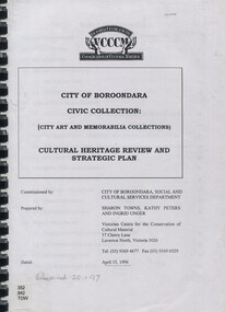
Book, City of Boroondara Civic Collection: (City Art and Memorabilia Collections) Cultural Heritage Review and Straegic Plan, 1996
This publication explains an approach to manage the collection and develop a strategic plan for its exposure to the public through community participation and access, interpretations and exhibitions.This publication explains an approach to manage the collection and develop a strategic plan for its exposure to the public through community participation and access, interpretations and exhibitions.boroondara council - art collections, art ad state, cultural policy, boroondara history -
 City of Greater Bendigo - Civic Collection
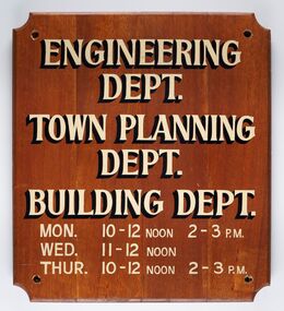
Sign - Municipal Departments Opening Times
History of this item is unknown but was used by one of the City, Shire or Borough Council's to advertise various department opening hours.Sign constructed from four pieces of wood. Hand painted text advertising engineering, town planning and building departments opening days and times.ENGINEERING / DEPT. / TOWN PLANNING / DEPT./ BUILDING DEPT. / MON. 10 - 12 NOON 2 - 3 PM / WED. 11 - 12 NOON / THUR. 10 - 12 NOON 2 - 3 PMcity of greater bendigo signs, city of greater bendigo administration item -
Friends of Ballarat Botanical Gardens History Group
Work on paper - Ballarat Botanical Gardens by Lake Wendouree, The Fernery (Palm House), C 2002
The article was produced by the Ballarat City Council entitled "The Fernery". It deals with developments, purpose and plans for the Fernery from 1955.This page testifies to the importance Ballarat City Council attached to the Fernery around the turn of the century and the plan to make it "the next landmark project", after the Australian Ex-POW Monument was finished in 2004.One page of 6 paragraphs in font 12.Logo, central top of page, "Ballarat Botanical Gardens by Lake Wendouree" in black and white.john garner, doctor, john garner collection, ballarat botanical gardens, the fernery, friends of ballarat botanical gardens, ballarat botanical gardens masterplan and management strategy, ballarat city council, gardens, ballarat -
Friends of Ballarat Botanical Gardens History Group
Work on paper - Report Book, Ballarat City Council, May, 1890, Ballarat Botanical Gardens and Lake Wendouree, 1890
This page (3) of the May Report Book, 1890, covers 9 topics of news and matters of concern relating to the Ballarat Botanical Gardens, the Lake and Victoria Park.This Report gives a clear idea of the condition, progress made and plans for the Gardens and the Lake in 1890 and therefore is historically significant.1 sheet of paper, printed closely in font 14, with a photocopy line of the page (3) down the lefthand side of the page. The last line of the page is partially cut off but readable. Written at the top of the page in blue biro, "May Rep. Book, 1890 and beneath Win Little" (?) "Pavilion" is asterisked in black biro halfway down the 2nd paragraph and "Memorial to late Cr. Claxton" is marked in green. john garner, doctor, john garner collection, friends of ballarat botanical gardens, ballarat city council., pavilion, lake wendouree, rush cutting, improvements to foreshore, pisciculture, park and arbor day, swans., new green house, 1890, ballarat city council report books, ballarat botanical gardens, gardens, ballarat -
Friends of Ballarat Botanical Gardens History Group
Work on paper - Victoria Park Precinct, City of Ballarat, Notes on the Parkland in the Nineteenth Century, Unknown
This page gives information about Victoria Park essentially from 1884-1894.Some idea is given here of Victoria Park back in history and plans for the planting of trees.1 page headed Victoria Park with a rough sketch of the Parkland area. There is an unfinished sentence at the bottom of the page and no page to follow.Nonejohn garner, doctor john garner, weston bates, george longley, curator, ballarat botanical gardens, night soil, ballarat council parks and gardens committee, gum trees, pines, victoria park, history friends of ballarat botanical gardens, john garner collection, gardens, ballarat -
 Friends of Ballarat Botanical Gardens History Group
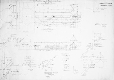
Plan - Timber Fernery at Botanical Gardens, Architectural drawing
History of Ballarat Botanical Gardens, Technical drawingWhite paper; photocopy showing black line drawings of planned Fernery; Ballarat Botanical Gardens 1925L.H. Finch. Assoc. M. Inst. C. E. City Engineer 1 July, 1925fernery, architectural drawing -
 Friends of Ballarat Botanical Gardens History Group
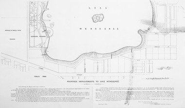
Plan - Photocopy on paper, Proposed Improvements to Lake Wendouree, 22 April 1873
Photocopy on papermap, lake wendouree, ballarat city council -
Canterbury History Group
Document - Lease between Mayor, Councillors and Citizens of the City Of Camberwell and Trustees of the Canterbury Bowling Club, 1975
Lease between City of Camberwell and Harry Cecil Worden, William James Adams and Arthur Evan Banks as Trustees of Canterbury Bowling Club.canterbury, canterbury bowling club, kendall street, city of camberwell, lawn bowls, worden> harry cecil, adams> william james, banks> arthur evan, legal documents, plans -
Canterbury History Group
Letter - Maling Road site rezoned as a result of consensus, 11/10/1989 12:00:00 AM
Letter to the Progress Press , 11 October 1989, from Julia Norris describing the background to the rezoning of the old theatre site in Maling Road Canterbury.canterbury, maling road, norris> julia, town planning, shops, city of boroondara, maling road neighbourhood residents' group -
Canterbury History Group
Document - Planning for our future, City of Boroondara, 1/07/2014 12:00:00 AM
City of Boroondara paper describing the approval of the Victorian Government to approve new Residential Zones in some areas of Boroondara. Includes a map of the areas affectedboroondara, city of boroondara, amendment c199, residential development, victorian government, local laws, ross> coral -
Canterbury History Group
Document - Lowell Chen, Urban Planning Special Committee - City of Boroondara, 1/12/2011 12:00:00 AM
Kew and Hawthorn. Further Heritage Investigations. Attachments for item: UPC3. Individual Heritage Overlays: Authorisation and Exhibition of Planning Scheme Amendment. Summary Report Prepared for the City of Boroondara. Item 3 Emulation Hall, Canterbury. pages 174-177. Includes black and white photographscanterbury, rochester road, dunstan reynolds & partners, egyptian revival style, emulation hall, historic buildings, masonic lodges -
Canterbury History Group
Map - Maling Road Built form Map, Ciy of Boroondara, 2015
Map copied from the 'Urban Planning Special Committee Agenda' Design and Development Overlay- Schedule 23 showing heritage property on Maling Road. Produced by The City of Boroondaracanterbury, maling road, heritage buildings, city of boroondara, urban planning special committee agenda, maps -
Canterbury History Group
Article, Junction Centre concerns are unfounded
Issue of the Camberwell City News mainly reporting on the opposition to the proposed redevelopment of the Camberwell Junction Shopping Centrecanterbury, canterbury road, camberwell junction, camberwell planning scheme, pigot> jan, street trees, pioneers, town planning, library bicentennial collection sponsors -
Canterbury History Group
Article, Elgar, Kerrie, A city divided
Article from the Melbourne Weekly, 1995 reporting on the redevelopment of the Canterbury Mansions to offices and the effect this has had on the availability of rooms to rent in the camberwell area. Includes 2 coloured photographs of the exterior of the buildingcanterbury, canterbury road, wattle valley road, canterbury mansions, city of boroondara, public housing, town planning, elgar> kerrie, boarding houses, spivak> gary -
Friends of Ballarat Botanical Gardens History Group
Work on paper - A Future Plan, The Stoddart Statue and the Future of the Collection, c 2010
Author unknown. Significant in detailing a plan for the future of the Statue Collection C 2010.2 photocopies of a pamphlet, printed on both sidesPrinted logo of Clark Conservatory in black and white, by"Lake Wendouree" and words "City of Ballarat".john garner collection, garner, dr, statues, ballarat botanical gardens, ballarat, gardens, thomas stoddart, the stoddart collection -
Friends of Ballarat Botanical Gardens History Group
Work on paper - Manager, Ballarat Botanical Gardens, City of Ballarat, Interview with Ian ROSSITER by John Garner, 26 May 2006, 26 May 2006
Ian Rossiter, City of Ballarat, Manager of Strategy Development and Corporate Projects& Ballarat Botanical Gardens, interviewed by Doctor John Garner for the Friends of the Botanical Gardens Oral History Project.The interview is valuable in giving information and insights of the Manager of the Gardens over fourteen years.All visiblejohn garner collection, garner, rossiter, interview, ballarat botanical gardens, ballarat, gardens, doctor, ian rossiter, horticulture, robert clark centre, fernery, prisoner of war memorial, sequoias, master plan, wetlands, curator's house, statues -
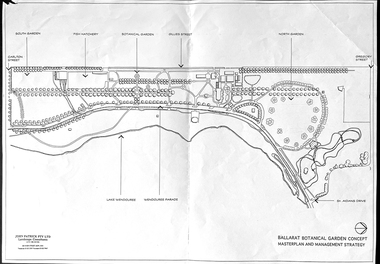 Friends of Ballarat Botanical Gardens History Group
Work on paper - Ballarat Botanical Garden Concept, Masterplan and Management Strategy, Unknown
This map is important in terms of the planning and management of the Ballarat Botanic Gardens The Map adds to our understanding and knowledge of the history of the Ballarat Botanical Gardens 1 page of a map in black and white. the number 44 is circled in pencil on the top righthand corner of the back of the page.john garner, doctor, john garner collection, ballarat botanic gardens, maps, masterplan, management strategy, john patrick, landscape consultants, ballarat city council, friends of ballarat botanical gardens, gardens, ballarat -
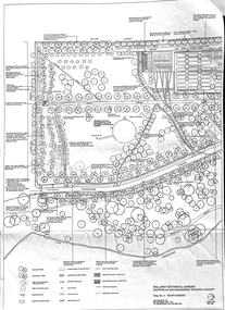 Friends of Ballarat Botanical Gardens History Group
Work on paper - Ballarat Botanical Gardens Master Plan, Final Draft 1995, 1995
This is the "Final Draft" of the Ballarat Botanical Gardens Masterplan in 1995.This document gives some insight into how the Ballarat Botanical Gardens have developed since 1995.There are 6 pages of print and 5 mapsThe City of Ballarat logo is in the centre of p.1.doctor john garner, john garner, john garner collection, friends of ballarat botanical gardens, ballarat botanical gardens, masterplan, gardens, ballarat, drawings -
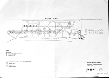 Friends of Ballarat Botanical Gardens History Group
Work on paper - Ballarat Botanical Garden Conservation Analysis and Policy, Volume 1, December 1994 and 2002, December 1994 and April/May 2002
The work entitled Ballarat Botanical Garden Conservation Analysis and Policy was prepared for the City of Ballarat.The pages selected give some perspective on the policy and planning of the Ballarat Botanical Gardens in the recent past.14 pages printed on both sides with black and white pictures and one map. Pages are not numbered consecutively; a selection has been made from the work cited in the name and title."Joan" is printed in blue biro in the top lefthand corner of the title page. [Presumably Joan Garner, President of the FBBG].ballarat botanical garden, conservation analysis and policy, city of ballarat, allom lovell & associates pty ltd., conservation architects, john patrick pty.ltd., landscape architects, friends of ballarat botanical gardens, john garner, doctor john garner, john garner collection, gardens, ballarat -
 Melton City Libraries
Document, Minns Family Reunion, 2004
"A perpetual spring in the adjacent creek provided a steady supply of fresh water to the site on which the homestead is built. Although we can not be certain of the identity of the builder, the first stage of ‘The Willows’ homestead appears to have been constructed in the mid 1850s. The house is situated on Crown Allotment No.1 (No Section), Parish of Kororoit, an allotment of 5 acres 3 roods 4 perches. Although it had surveyed the land, the Crown did not offer it for sale until 22nd November 1861, at which time it was purchased by Charles March Williams. (Although the property is directly opposite and immediately adjacent to the Township of Melton, and was sold as ‘Suburban Allotment 33’, it was situated within the Shire of Braybrook rather than the Shire of Melton until 1917.) Considerable improvements had taken place on the land prior to the Crown sale. When CM Williams purchased the allotment in November 1861 he paid £23.5.0 for the land itself, and valued the improvements at £400. Even allowing for some exaggeration by Williams, this is an extremely high valuation for improvements, and must have included a house. Some local research has claimed that in 1858 Williams had taken over the interest of a Mr Parkinson in the property, and that Parkinson built the house upon taking possession of the land c.1855. It was definitely built by 1861, when a map shows a square building on the site marked as ‘House’. The property is important in the district for its association with the establishment of the pound. The district pound had been established in 1854, when George Scarborough of Mount Cottrell (Mt Cottrell Road, south of Greigs Road) was appointed pound-keeper. Scarborough resigned in 1857. The pound was moved to Melton following agitation from local farmers and Charles March Williams appointed pound-keeper on 26th April 1858. Williams, the son of a doctor, had been born in London. Reminiscences of local residents of the time, as recorded in the Express newspaper, note Williams’ success in breeding horses on the property. Sales of up to 60 guineas were noted. Whether this was from Williams’s own stock or from unclaimed pound stock is not made clear. Williams appeared before a government inquiry in 1860 and advocated registration of all stock brands in the State. Williams died in 1862 leaving a widow, Catherine, and five living children aged 15 years to five months. At the time of his death Williams had entered negotiations with one Matthew Devenish and had a mortgage of £100 on allotments 1 and 2, Parish of Kororoit. Catherine Williams was appointed pound-keeper on 2 September 1863, with her eldest son Charles as her assistant. Her tenure was short for on 22nd March 1864 George Minns senior paid Matthew Devenish £135 for allotments 1 and 2 Parish of Kororoit (considerably less than Williams had claimed the property was worth in 1861) and on the same day paid William Tullidge £45 for the adjoining allotments 3 and 4. In April 1867, James Ebden Minns, the newly married son of George senior became the owner of The Willows property having entered into a mortgage arrangement with his father to the extent of £200. At the time George Minns was residing in Kaarimba having left Melton in 1867 for a short trip to England and upon his return having taken up a selection in the Kaarimba district with his son Frederick who had a hotel licence there. James paid out the mortgage on 2-1-1873. James Minns was appointed pound-keeper in 1872; in 1885 the pound was moved elsewhere and Minns purchased the old pound site and added it to his farm. The Willows residence underwent a major change about this time. A two room extension, similar in style but with a lower elevation was added to the original rear of the house with a chimney matching the distinctive originals. Window arrangements did not match the original but became a feature of the façade when the new addition became the front of the building. Six buttresses were attached to the east and west walls of the old building, two to the south wall and the whole rendered with mortar to give the appearance of dressed stonework around the windows. Galvanized iron was placed over the shingles and a verandah added on three sides. By 1876 The Willows was the homestead for a thriving mixed farm of 340 acres of which 156 was rented from a H. Ruck. In October of that year the Australasian travelling reporter visited and reported on the property. In common with the nearly every other property in the district the farm had ‘recently’ (generally within the last two years) abandoned cultivation of crops, and turned over completely to cattle pasture. Butter making was the principal occupation of the farm, which had about 50 head of cattle, a large proportion of which were milking cows. The reporter also noted that a ‘large number of pigs are kept upon this farm and are found to be very profitable stock’. Their manure was used in an orchard and garden in which ‘large quantities of lucerne and prairie grass are grown for the use of stock when ordinary feed is scarce’. Two bores attached to deep brick lined wells supplied water for the house in addition to the farm. A commodious timber barn and necessary sheds had also been constructed. Access to the property was improved following the construction of the bluestone ford across the creek c.1887, when the recreation ground came into use. Prior to this date it may have been that the crossing referred to as ‘Mr Minns bridge’ was used. This appears to have been a flimsy structure and has but two references in Council reports in the Melton Express in the 1880’s. It is believed that in the late 1890’s a timber building was added near the rear of the building to house a kitchen, ablutions and laundry rooms and rooms for seasonal workers. This was attached to the house by means of a trellised walkway using the original front entry to the house (long since the back door). A photograph of this building appears in a local history of Melton. This was demolished in recent decades during the period when the house was tenanted (after the Minns family had left). James Minns son, George, took over the property following his marriage to Alice Walsh in 1903. James and Caroline moved into a house on the former JH Games property at the eastern end of Henry Street. George held the position of Shire Secretary for Melton for 40 years. He was a most prominent member of the community being Secretary to, among others, the Melton Coursing Club, the Shooting Club and the Cemetery Trust. He also rode with the hunting parties who sported across the Plains and were entertained at Mount Kororoit. George and Alice had one son, Norman who followed his father into local government and became Secretary of the Shire of Werribee completing a record term in this position. George retired to Werribee in 1951, where he died in 1965. The National Trust records note that James Ebden Minns and his sons were ‘leading men of the district, Justices of the Peace, and Shire Councillors’. It claims that Sir Thomas Bent was a frequent visitor. The Willows passed into the hands of George’s grandson, Bruce Minns and the property was let for a number of years. In the 1960s it became vacant and was subject to vandalism. Major structural problems arose with the part demolition of the roof, the loss of windows and doors and holes dug into and under the floorboards. The outbuildings were particularly targeted. Following widespread public support, the Shire of Melton purchased the house, with 3.75 acres of land, in 1972. In 1975 the Shire of Melton and the Melton and District Historical Society were successful in nominating the building for National Trust classification, and then the Australian Heritage Commission’s Register of the National Estate. The AHC particularly noted its ‘townscape importance’. It was envisaged that the farmhouse would form ‘a picturesque centrepiece to Melton’s planned … historical park, along with Dunvegan bluestone cottage … and similar structures as they become available.’ In a time of great Melton’s ‘satellite city’ development the Council spelt out its broader vision in its submission to the AHC: ‘Melton is destined to become, by the end of the present century, a city of between 75,000 and 100,000 people. Significant relics of the past, such as ‘The Willows’, regrettably will be rare in that situation. It is essential that sufficient tangible links with Melton’s pioneering days remain to promote in the new community a sense of history and continuity’. Under the direction of ‘The Willows’ Restoration Committee and consultant architect John Hitch, all outbuildings, with the exception of the garage and toilet, were demolished and the dwelling house restored. Finances were provided by the Shire of Melton and the National Estate Grants Program, and considerable amount of voluntary labour was provided by the local community. The orchard was removed, and remaining wooden buildings were relocated to provide an open vista for visitors to the Park. The property was furnished with donations from district families keen to preserve this example of pioneer life in the area. The Willows became the headquarters of the Melton and District Historical Society". Invitation to the family reunion at the Willowslocal identities, pioneer families -
Canterbury History Group
Letter - Strathcona promises to stay within its site, Walker, James, 4/08/2003 12:00:00 AM
Letter from James Walker published in the Progress Leader 4 August 2003, regarding the expansion plans of Strathcona Baptist Girls Grammar Schoolcanterbury, prospect hill road, strathcona baptist girls grammar school, city of boroondara, town planning, schools, resident action -
Canterbury History Group
Document - The stained glass windows by Christain Waller at St Paul's Anglican Church, Canterbury, National Trust of Australia (Victoria), 2005
Classification Report on the Christian Waller windows. Lists assessment criteria, plan of the interior of the church, photocopies of the design of the windows and exterior of the church, and a list of some of Christain Waller's windows together with their location.canterbury, margaret street, church street, st paul's anglican church, boroondara city council, national trust of australia (victoria), waller> christian, stained glass, windows, redman family, churches