Showing 1821 items
matching hand coloured
-
 Port Fairy Historical Society Museum and Archives
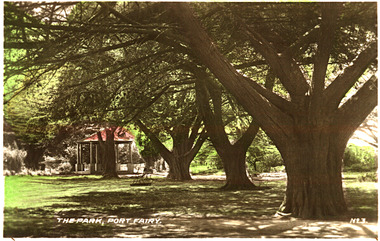
Postcard, The Park Port Fairy
... Coloured photograph (hand tinted) of the stand of cypress... garden Cypress tree rotunda The Park, Port Fairy - No. 3 Coloured ...Funding for the construction of the Rotunda was bequeathed in the Will of local resident Mrs Annie Williams, who was born in Daylesford in 1872 and died in Kew in 1930. Annie’s Will stipulated that the remaining value of her Estate be spent on erecting a Bandstand in the Port Fairy Botanical Gardens dedicated to the memory of her brother Hugh, a stretcher bearer in WW1 and who died in 1921 after being discharged with health issues, her husband Henry, and herself naturally. There is a plaque dedicated to Annie on the Bandstand She requested that the Bandstand be a replica of the one at Daylesford but by 1933 the value of her Estate had diminished to £76.4/8 which was insufficient to cover a similar design and the Borough Councillors felt it would be too extravagant for the Port Fairy Botanical Gardens. Local builder J.J.McLaren’s tender of £71.15/- was accepted and the octagonal concrete pillared construction was completed with the use of sustenance labour the following year. The Bandstand was opened in December, 1934 with a performance by the Port Fairy Band and local residents enjoying the entertainment and a picnic. In 1934 it was reported that there was some fuss in Council because of the whereabouts of the sum of approximately £3/- , being the amount left over from the build. After some months of debate, in which the Councillors suggested that the Engineer had used the money inappropriately, and to which he responded that the build had cost more than the quote, the matter seems to have ended there Coloured photograph (hand tinted) of the stand of cypress trees leading to the rotundaThe Park, Port Fairy - No. 3botanical, garden, cypress, tree, rotunda -
 Warrnambool and District Historical Society Inc.
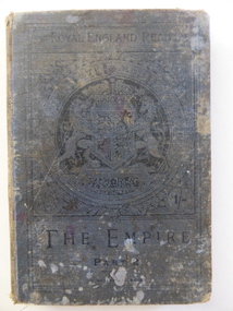
Book, T Nelson and Sons London and Edinburgh, The Empire Part Two
... . The text contains many illustrations, some of which have been hand... of which have been hand-coloured. The first two or three pages ...This school text book has been used at the Wangoom State School in the late 19th century by Henrietta Giles. The Wangoom school was established in 1865 as the Wangoom Common School No. 645 and later became the Wangoom State School. It is now closed. Henrietta Giles was a member of the Giles family that lived on the Allansford Road.This book is of interest as an example of the school texts used by children in Victoria late in the 19th century. It contains the history of Britain in Tudor and Stewart times and has no Australian content. The book is also of interest as it was used by Henrietta Giles, a member of the family that settled early in the Warrnambool district. This is a hard cover book of 331 pages plus some supplementary material at the end. The cover (once blue?) is much stained and torn and the embossed black lettering and British Coat of Arms on the front cover and the spine are now almost indecipherable. Part of the back cover and the bottom edges of some pages have been eaten away. The inscription is handwritten in red ink. The text contains many illustrations, some of which have been hand-coloured. The first two or three pages are missing.‘Henrietta Giles, Wangoom S.S. No. 645, 22/7/91’henrietta giles, wangoom state school -
 Federation University Historical Collection
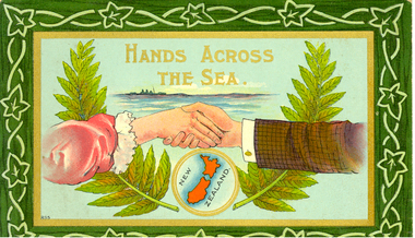
Postcard, Hands Across the Sea. New Zealand, Circa 1910
... Hand-coloured postcard in which the picture is framed... mother who is visiting New Zealand. Hand-coloured postcard ...Frank Wright was a renown resident of Smeaton, where he was born. He lived at Laura Villa, and attended Smeaton State School. His father William was a gold miner and his mother's name was Sarah. Sarah spent six months in New Zealand in 1910. William and Sarah's family won many singing and instrumental awards. Frank was tutored by Percy Code and was awarded a gold medal for the highest marks in the ALCM examinations in the British Colonies at the age of seventeen years. He became the Australian Open Cornet Champion by the age of eighteen. A year later, Frank conducted the City of Ballarat Band, and later the Ballarat Soldiers’ Memorial Band. He formed the Frank Wright Frisco Band and Frank Wright and his Coliseum Orchestra. These bands won many South Street awards, and Frank as conductor won many awards in the Australian Band Championship contest. In 1933 Frank Wright sailed to England to conduct the famous St Hilda’s Band and was later appointed Musical Director of the London County Council, where he organized many amazing concerts in parks, in and around the London district. He was made Professor of Brass and Military Band Scoring and conducted at the Guildhall of Music and Drama. Frank was often invited to adjudicate Brass Band Championships around Europe, in Australia, including South Street and in New Zealand. The Frank Wright Medal at the Royal South Street competition is awarded to an individual recognized as making an outstanding contribution to brass music in Australia.Hand-coloured postcard in which the picture is framed by a border of a leaf and vine pattern. The picture is of the lower arms of a woman from the left hand side of the card and a man from the right hand side of the card shaking hands in the middle. Behind and below the hands is a small map of New Zealand in a golden circle. New Zealand fern is positioned from the circle up behind the arms to the top of the card on both sides and above the hands is a depiction of a ship sailing on the sea.The postcard contains a message to Frank Wright from his mother who is visiting New Zealand.frank wright, sarah wright, new zealand, postcard -
 Bendigo Historical Society Inc.
Postcard - TOWN HALL, BENDIGO
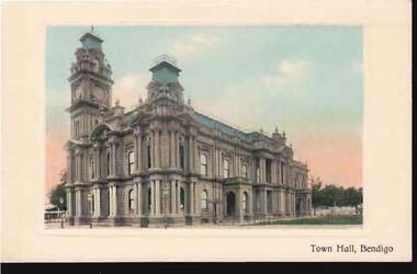
... Postcard: hand coloured image of Town Hall, Bendigo... ? ) Postcard: hand coloured image of Town Hall, Bendigo. On rear ...Postcard: hand coloured image of Town Hall, Bendigo. On rear: written in black ink ' Dear Auntie, We got here allright, & Billy Bush & Ronny kept us laughing most of the time. I started school today and Reg started School of Mines. It is not very nice starting again. This is the only postcard I can find; but suppose it will do. With love from Reg and Merle' Card is postmarked with a penny stamp. No date visible. No address on card.bendigo, streetscape, town hall, bendigo, post office, merle ( bush ? ) -
 Bendigo Historical Society Inc.
Photograph - BENDIGO PHOTOGRAPHIC VIEWS
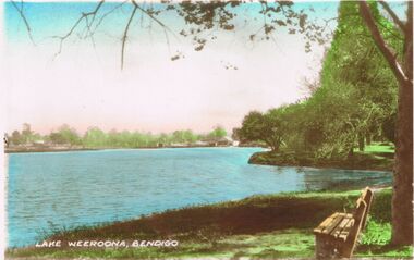
... reading. Valentine 's Snapshots. Eight real photographs hand... photographs hand coloured, Bendigo, Vic No 2 published ...Eight colour photographic views of Bendigo dating in the 1950's period. Enclosed within envelope printed heading reading. Valentine 's Snapshots. Eight real photographs hand coloured, Bendigo, Vic No 2 published by the Valentine Publishing Co, Melbourne and Sydney. Photos are of; Lake Weeroona Bendigo, The Mall. Pall Mall Bendigo, The Conservatory Gardens Bendigo, Rosalind park Gardens Bendigo, Conservatory Gardens Bendigo, Rosalind Park and Deborah Gold Mine looking towards Bendigo.Valentine's Snapshots, Bendigo, Vic. No2. Published by the Valentine Publishing Co., Pty. Ltd Melbourne and Sydneybendigo, streetscape, general street views -
 Melbourne Tram Museum
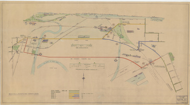
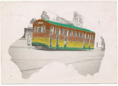
Drawing, Melbourne & Metropolitan Tramways Board (MMTB), "Footscray - City Tram Schemes - Perspective Overview", Dec. 1947
... Drawing - hand coloured - not formally titled - "Footscray... Spare (dup) Drawing - hand coloured - not formally titled ...Drawing - hand coloured - not formally titled - "Footscray - City Tram Schemes - Perspective Overview", shows existing tramways, proposed conversions, four different schemes or proposals and the length of double track. Shows roads, bridges, railway lines, docks, industry location, road cross sections and other planning features. Dated 4-12-1947, drawing No. P10868. Note pdf version of this drawing on the images file, but will not open with dbtext works pdf viewer. Converted to a jpg which does open.On left hand edge on the rear has in pencil - "Footscray - City Tram Schemes - Perspective Overview" P10868 1947 Spare (dup)trams, tramways, footscray, new tramway, north melbourne, spencer st, victoria st, bridges -
 Melbourne Tram Museum
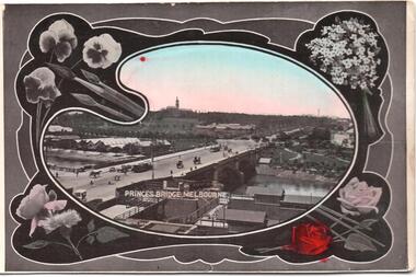
Postcard, SEMCO, "Princes Bridge Melbourne", mid 1900's?
... Divided back postcard featuring a hand coloured black... St Station Divided back postcard featuring a hand coloured ...Divided back postcard featuring a hand coloured black and white photograph of a view looking from Flinders St towards Government House, c1900, or from the roof of the Flinders St Station which could be under construction. Embossed Photograph enclosed within an artists palette, surrounded by roses. Note the buildings between the bridge and Government house - a former asylum? Card from the SEMCO Series Box 545 GPO Melbourne. Addressed to Miss V Hall of Blackwood.trams, tramways, princes bridge, cable trams, flinders st, flinders st station -
 Kew Historical Society Inc
Plan, Melbourne & Metropolitan Board of Works : Borough of Kew : Detail Plan No.1350, 1910
... Town, then City of Kew. The hand-coloured sections of buildings...-five hand-coloured plans, backed with linen, are of statewide ...The Melbourne and Metropolitan Board of Works (MMBW) plans were produced from the 1890s to the 1950s. They were crucial to the design and development of Melbourne's sewerage and drainage system. The plans, at a scale of 40 feet to 1 inch (1:480), provide a detailed historical record of Melbourne streetscapes and environmental features. Each plan covers one or two street blocks (roughly six streets), showing details of buildings, including garden layouts and ownership boundaries, and features such as laneways, drains, bridges, parks, municipal boundaries and other prominent landmarks as they existed at the time each plan was produced. (Source: State Library of Victoria). This plan forms part of a large group of MMBW plans and maps that was donated to the Society by the Mr Poulter, City Engineer of the City of Kew in 1989. Within this collection, thirty-five hand-coloured plans, backed with linen, are of statewide significance as they include annotations that provide details of construction materials used in buildings in the first decade of the 20th century as well as additional information about land ownership and usage. The copies in the Public Record Office Victoria and the State Library of Victoria are monochrome versions which do not denote building materials so that the maps in this collection are invaluable and unique tools for researchers and heritage consultants. A number of the plans are not held in the collection of the State Library of Victoria so they have the additional attribute of rarity.Original survey plan, issued by the MMBW to a contractor with responsibility for constructing sewers in the area identified on the plan within the Borough of Kew. The plan was at some stage hand-coloured, possibly by the contractor, but more likely by officers working in the Engineering Department of the Borough and later Town, then City of Kew. The hand-coloured sections of buildings on the plan were used to denote masonry or brick constructions (pink), weatherboard constructions (yellow), and public buildings (grey). MMBW Plan No. 1350 depicts the western end of Studley Park on the north side of the Studley Park Road. ‘Raheen’, then the home of Sir Henry Wrixon is named, the plan identifying those parts of the house that were built of brick and timber. The two houses between Raheen and the River Yarra are also shown. Other parts of the plan show neighbouring streets: Yarra Street, Studley Park Avenue, Studley Street and Fenwick Street. Each, apart from Fenwick Street was subsequently renamed. At the corner of Fenwick and Stawell Streets, the home of Joseph Butterworth Coombs, later called ‘Hope Mansell’, is represented but unnamed.melbourne and metropolitan board of works, detail plans, mmbw 1350, cartography -
 Kew Historical Society Inc
Plan, Melbourne & Metropolitan Board of Works : Borough of Kew : Detail Plan No.1565, 1905
... Town, then City of Kew. The hand-coloured sections of buildings...-five hand-coloured plans, backed with linen, are of statewide ...The Melbourne and Metropolitan Board of Works (MMBW) plans were produced from the 1890s to the 1950s. They were crucial to the design and development of Melbourne's sewerage and drainage system. The plans, at a scale of 40 feet to 1 inch (1:480), provide a detailed historical record of Melbourne streetscapes and environmental features. Each plan covers one or two street blocks (roughly six streets), showing details of buildings, including garden layouts and ownership boundaries, and features such as laneways, drains, bridges, parks, municipal boundaries and other prominent landmarks as they existed at the time each plan was produced. (Source: State Library of Victoria). This plan forms part of a large group of MMBW plans and maps that was donated to the Society by the Mr Poulter, City Engineer of the City of Kew in 1989. Within this collection, thirty-five hand-coloured plans, backed with linen, are of statewide significance as they include annotations that provide details of construction materials used in buildings in the first decade of the 20th century as well as additional information about land ownership and usage. The copies in the Public Record Office Victoria and the State Library of Victoria are monochrome versions which do not denote building materials so that the maps in this collection are invaluable and unique tools for researchers and heritage consultants. A number of the plans are not held in the collection of the State Library of Victoria so they have the additional attribute of rarity.Original survey plan, issued by the MMBW to a contractor with responsibility for constructing sewers in the area identified on the plan within the Borough of Kew. The plan was at some stage hand-coloured, possibly by the contractor, but more likely by officers working in the Engineering Department of the Borough and later Town, then City of Kew. The hand-coloured sections of buildings on the plan were used to denote masonry or brick constructions (pink), weatherboard constructions (yellow), and public buildings (grey). MMBW Plan No.1565 is an example of a plan where a number of streets have been created since the area was surveyed, or in other cases renamed. The plan shows those streets that were bordered by Ross Street, Mount Street, Sackville Street and Burke Road. Since 1905, Mawson Street has been created and Mont Albert Road renamed as Dean Street. Named houses on the plan include ‘Tyrol’, ‘Glengorse’, ‘Theodore Villa’, ‘Arncliffe’, ‘Ballynira’ and ‘Hazeldene’. The plan also shows a Wesleyan Church in Sackville Street. In 1883, the Church’s Sunday School celebrated its silver anniversary.melbourne and metropolitan board of works, detail plans, mmbw 1565, cartography -
 Vision Australia
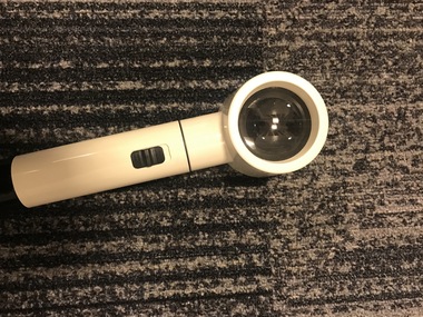
Functional object - Object, Eschenback, Hand held magnifier
... Hand held cream coloured plastic optical magnifier...Vision Australia 454 Glenferrie Road Kooyong melbourne Hand ...Hand held cream coloured plastic optical magnifier with small globe inset under lenses. The black button on handle turns globe, which is powered by batteries, on and off. The magnifier can be detached to replace the globe or exchanged for a different strength. Cream and black handle with a black button to turn on light and a detachable magnifying glass attached at top.6/100 on magnifierassistive devices, ecshenbach -
 Port Melbourne Historical & Preservation Society
Plan - Toll bar, house and closet, Sandridge, Charles Clay?, Borough Surveyor, 1860s - 1870s
... and closet, hand drawn and coloured 1860s-70s. Master copy.... of Sandridge toll bar, house and closet, hand drawn and coloured 1860s ...Plan and elevation for Borough of Sandridge toll bar, house and closet, hand drawn and coloured 1860s-70s. Master copy.Signed by Chas. Clay, Suveyor and John L. Forrester (?) and witnessed bt Thomas R. Warren (?).built environment - civic, charles clay, thomas peek warren, john l forrester -
University of Melbourne, Burnley Campus Archives
Plan, Duck Pens at Burnley Competitions. Plan of Floor No 1, c. 1940
... Hand drawn plan, coloured. Plan of Floor of Duck Pens... Boulevard Richmond melbourne duck pens drainage Hand drawn plan ...Hand drawn plan, coloured. Plan of Floor of Duck Pens with Level for Drain. Imperial measurements, so before 1966.duck pens, drainage -
 Bendigo Historical Society Inc.
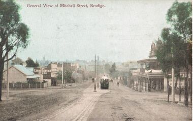
Postcard - ELAINE ROBB COLLECTION: MITCHELL STREET, BENDIGO
... Hand coloured postcard: view of Mitchell Street, looking.... Pater Hand coloured postcard: view of Mitchell Street, looking ...Hand coloured postcard: view of Mitchell Street, looking towards Pall Mall. "General View of Mitchell Street, Bendigo printed across top. Image shows tram in foreground, poles and line down centre of road. 'Sandhurst Coffee Palace' on banner outside two storey building with verandas and ornate pediments, on right hand side, 'The Living Centre' printed on the side of a shop on left side. Possibly late 1890's ? On rear of card: Post Card (W.T.P in ornate diamond shape) .W.T. Pater -
 Bendigo Historical Society Inc.
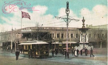
Postcard - ELAINE ROBB COLLECTION: COOPER'S CITY CLUB HOTEL, BENDIGO
... Hand coloured postcard. Cooper's City Club Hotel... BENDIGO Streetscape pall mall mitchell Hand coloured postcard ...Hand coloured postcard. Cooper's City Club Hotel, on the corner of Pall Mall and Mitchell Street in background. Alexandra Fountain on RH side, two trams in foreground,. On top of hotel a flagpole, with red and white flag, 'Cooper's City Club Hotel' Red stamp on top LH side of postcard, 'G. Cooper, Bendigo' surrounded by flourishes. Possibly late 1890's ? On back of postcard: Printed in Melbourne F.W.N. & Co, enclosed in laurel wreath print. Postcard, stamp, correspondence here, the address only here.bendigo, streetscape, pall mall, mitchell -
 Bendigo Historical Society Inc.
Photograph - Valentine's Bendigo Snapshots, abt 1940s
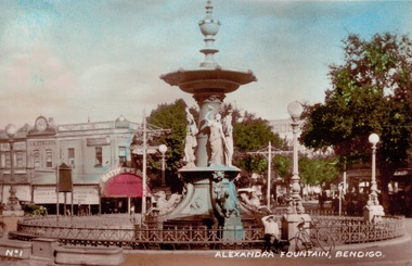
... ., No. 1. Eight real Photographs for your album, Hand Coloured... Bendigo, Vic., No. 1. Eight real Photographs for your album, Hand ...BHS CollectionValentine's Bendigo Snapshots Packet for Photos - Printed on the front of the envelope is "Valentine's Snapshots Bendigo, Vic., No. 1. Eight real Photographs for your album, Hand Coloured Published by the Valentine Publishing Co. Pty. Ltd, Melbourne" Photos of: No 1 Alexandra Fountain No 2 Town Hall No 3 The Conservatory Gardens No 4 The Swimming Pool No 5 View from Mitchell Street No 8 Queen Victoria Gardens No 9 King George 5th memorial, Conservatory Gardens No 10 Queen Victoria Gardenshistory, bendigo, valentines photos, alexandra fountain, no 2 town hall, no 3 the conservatory gardens, no 4 the swimming pool, no 5 view from mitchell street, no 8 queen victoria gardens, no 9 king george 5th memorial, conservatory gardens, no 10 queen victoria gardens -
 Bendigo Historical Society Inc.
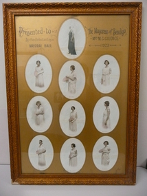
Photograph - GIUDICE COLLECTION: MAYORAL BALL DEBUTANTES PRESENTATION, 1923
... with a collage of 10 oval shaped hand coloured photographs, 9 of which... of the Mayoral Ball in 1923 with a collage of 10 oval shaped hand ...Framed presentation to the Mayoress of Bendigo Mrs.M.G.Giudice from the Debutantes of the Mayoral Ball in 1923 with a collage of 10 oval shaped hand coloured photographs, 9 of which are the Debutantes and 1 of the Mayoress, under glass with a gold mount and with a gold coloured timber frame. Debutantes have names printed underneath, Miss M Jeffrey, Miss D Moore, Miss V Mayne, Miss E Helwig, Miss M Houston, Miss C Helwig, Miss F Trevillian, Miss A Bolton, Miss M Herbel. Deframed 2022Vincent Kelly Pall Mall Bendigophotograph, portrait, female group, bendigo-history-mayoral ball- debutantes -
 Ballarat Tramway Museum
Photograph - Digital image, L.W. Torr Best Street Bowen Hill and Brisbane Q, 4/03/1939 12:00:00 AM
... 7000 for a hand coloured image.... 7000 for a hand coloured image. Photograph Digital image L.W ...Yields information about Ballarat tram 29 when it was dressed for the Floral Festival and the launch of the tram and how it was used by a small photograph publisher for sales.Digital image from the Wal Jack Ballarat Album of a postcard featuring the 1939 Floral Tram, photograph at the depot, rendered in colour and positioned within an outline of a map of Australia. Wal's notes date it as 4-3-1939. Uses the same base photo similar to 1369, but without the motor bike in the rear. On the rear has a the stamp "L.W. Torr Best Street Bowen Hill, Brisbane Q" See image i2 for rear of photograph. See Reg Item 7000 for a hand coloured image.Stamped on the rear of the photograph "L.W. Torr Best Street Bowen Hills, Brisbane Q" and the date stamp "5 May 1939"trams, tramways, floral tram, decorated trams, depot, tram 29 -
Bendigo Historical Society Inc.
Plan - MARKS COLLECTION: ALBERT PARK SERPENTINE HOUSE PLAN FOR H. LANSELL
... elevations, for house plan for H. Lansell, Serpentine. Hand coloured.... Lansell, Serpentine. Hand coloured drawings and floor plan ...Laminated plan showing house plan, side and front elevations, for house plan for H. Lansell, Serpentine. Hand coloured drawings and floor plan. Edwardian style, shows large house with maid's quarters, cellar, dining room, bedrooms, dressing room. On top of plan written in black pen Proposed Homestead, Albert Park, Serpentine, for H. Lansell Esq, scale eight feet to one inch, W. Beebe & G.D. Garvin, architects, late W. Beebe, Mitchell Street, Bendigo...bendigo, house, albert park, serpentine -
 University of Melbourne, Burnley Campus Archives
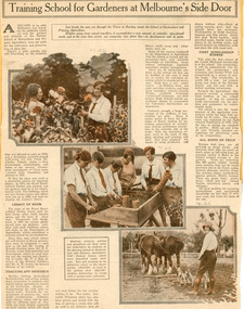
Newspaper - Newspaper Cutting, The Sun News-Pictorial, Training School for Gardeners at Melbourne's Side Door, 1929
... . The 3 hand-coloured illustrations are photos B91.82 Student... Week, which was instituted for this purpose. The 3 hand ...2 copies of Article from The Sun News-Pictorial, May 11, 1929, The Home Supplement, P. 1. Describes the activities and studies of students of the day. Refers to 1929 as the first year for the Cronin Memorial Scholarship and that the scholarship funds were raised from Garden Week, which was instituted for this purpose. The 3 hand-coloured illustrations are photos B91.82 Student examining dahlias, B91.83 Student potting and B91.86 Student cultivating, in the archival collection. Original article lent by Doris Baker (nee Barker, 1933).the sun news-pictorial, students, cronin memorial scholarship, garden week, doris baker (nee barker), dahlias, students working outside, potting, cultivating, draught horses -
 Melbourne Tram Museum
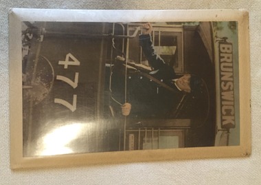
Photograph - Block Mounted Photograph, c1936-37
... for "Brunswick" Photograph may be hand coloured by a studio photographer.... for "Brunswick" Photograph may be hand coloured by a studio photographer ...Block mounted photograph on a metal backing sheet which has a packing between a stippled card sheet and the photograph to give a curved effect with an outer plastic cover and a mounting cord on rear. Photograph of John McMahon as MMTB conductor badge Number 772 on the rear platform of cable car trailer No. 477, with one hand on a hand brake. Shows the MMTB style conductors bag and ticket folder or holder. Has the destination sign set for "Brunswick" Photograph may be hand coloured by a studio photographer.trams, tramways, cable trams, mmtb, conductors, brunswick, tram 477 -
 Orbost & District Historical Society
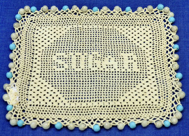
food cover, approx. 1940's
... Small square cream coloured hand crocheted sugar bowl cover... food. food-cover handcrafts crochet Small square cream coloured ...This handmade item represents an important pastime of Australian women of the late 19th to mid 20th century. Women's focus was the home and its decoration was important. Embroidery and crochet work was an affordable way to personalise and add aesthetic value, and examples of embroidered and crocheted pieces could be found in most Australian homes, decorating or protecting furniture, floors and walls, and keeping off flies and insects from food.Small square cream coloured hand crocheted sugar bowl cover. Word "sugar" is patterned into it. The beaded fringing is blue and white.food-cover handcrafts crochet -
Kew Historical Society Inc
Clothing, Cream Rayon Nightdress
... Cream coloured hand-made rayon (sic) nightdress featuring... Cream coloured hand-made rayon (sic) nightdress featuring multi ...The nightdress was owned, worn and donated by Betty Adeney, the descendant of one of the Kew pioneers. Her family gave its name to Adeney Avenue.Cream coloured hand-made rayon (sic) nightdress featuring multi-coloured machine embroidery. The nightdress has smocking at the waist. women's clothing, nightwear, nightdress, betty adeney -
 Warrnambool and District Historical Society Inc.
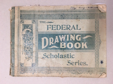
Book, The Federal Drawing Book, C 1930
... level. The maps appear to have been traced and hand-drawn... traced and hand-drawn and coloured. There is a loose newspaper ...This school book which was owned by George Mathieson contains maps and information on different countries around the world. It is handwritten and is probably of secondary school level. The maps appear to have been traced and hand-drawn and coloured. There is a loose newspaper map of the Dardenelles loose in the book. This book as an example of school work and geography in the early 20th century, has social and historical significance.Pale green light card cover with dark green pattern and text. Back cover is plain. It contains alternate pages of tracing paper in between normal pages. Bound with cotton? threadGeorge mathieson, written in ink on front cover.warrnambool, federal drawing book, george mathieson, school drawing book 1920's, -
 Ballarat Tramway Museum
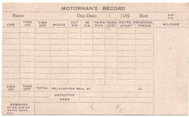
Document - Form, Electric Supply Co. of Vic (ESCo), "Motorman's Record", 1920s
... Record" with a hand drawn and coloured image of a Mt Pleasant..." with a hand drawn and coloured image of a Mt Pleasant Weekly ticket ...Form used by the ESCo in the 1920s to record the details of the Motorman's or Driver's work for the day. Notes Name, date, tramcar, time on, off, routes, trips, meter (power or electricity use), remarks and defects. See item 2544 for a SECV version of the late 1930s. On the rear is a hand drawn image of a Mt Pleasant - Doveton St weekly ticket morning and evening trips. Priced 1/6d.Demonstrates a form used to record the tramcar mileage on a daily basis.Preprinted form on off white card, titled "Motorman's Record" with a hand drawn and coloured image of a Mt Pleasant Weekly ticket on the rear.tramways, forms, tramcars, mileage, records, reports, esco, weekly tickets, mt pleasant -
 Melbourne Tram Museum
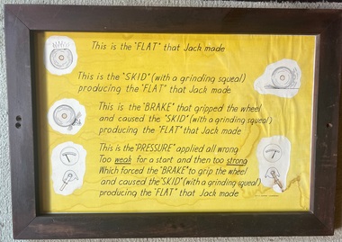
Poster - Framed, Mills Display, "This is the "FLAT" that jack made", 1950s
... back, perspex sheet with a coloured hand-made poster with three... masonite back, perspex sheet with a coloured hand-made poster ...Poster used in the Hawthorn Training Centre to teach drivers about the outcome of poor braking and skidding the wheels thereby putting flats on the tram wheels. Demonstrates poster to teach drivers the issues of poor braking which could result in noisy flats.Framed poster - brown wooden frame with secured masonite back, perspex sheet with a coloured hand-made poster with three screw holes. tramways, trams, tram brakes, tramcar maintenance, drivers, training -
 Kew Historical Society Inc
Plan, Melbourne & Metropolitan Board of Works. Borough of Kew Detail Plan No.1579, 1904
... Town, then City of Kew. The hand-coloured sections of buildings...-five hand-coloured plans, backed with linen, are of statewide ...The Melbourne and Metropolitan Board of Works (MMBW) plans were produced from the 1890s to the 1950s. They were crucial to the design and development of Melbourne's sewerage and drainage system. The plans, at a scale of 40 feet to 1 inch (1:480), provide a detailed historical record of Melbourne streetscapes and environmental features. Each plan covers one or two street blocks (roughly six streets), showing details of buildings, including garden layouts and ownership boundaries, and features such as laneways, drains, bridges, parks, municipal boundaries and other prominent landmarks as they existed at the time each plan was produced. (Source: State Library of Victoria). This plan forms part of a large group of MMBW plans and maps that was donated to the Society by the Mr Poulter, City Engineer of the City of Kew in 1989. Within this collection, thirty-five hand-coloured plans, backed with linen, are of statewide significance as they include annotations that provide details of construction materials used in buildings in the first decade of the 20th century as well as additional information about land ownership and usage. The copies in the Public Record Office Victoria and the State Library of Victoria are monochrome versions which do not denote building materials so that the maps in this collection are invaluable and unique tools for researchers and heritage consultants. A number of the plans are not held in the collection of the State Library of Victoria so they have the additional attribute of rarity.Original survey plan, issued by the MMBW to a contractor with responsibility for constructing sewers in the area identified on the plan within the Borough of Kew. The plan was at some stage hand-coloured, possibly by the contractor, but more likely by officers working in the Engineering Department of the Borough and later Town, then City of Kew. The hand-coloured sections of buildings on the plan were used to denote masonry or brick constructions (pink), weatherboard constructions (yellow), and public buildings (grey). While MMBW Plan No.1579 does not include many buildings, those that it does show are significant to Kew’s history. These include the ‘Kew [Railway] Station’ in Denmark Street and the ‘Recreation Hall’ and rear courts off Wellington Street. The plan shows the outline of the Recreation Hall, constructed in 1880, at the rear of which is listed a bowling green, two tennis courts, a ‘skittle alley’ and a pavilion. When the Hall was first built, the Kew Cricket Club occupied an adjacent ground, however in 1885 this was acquired by the State Government as the future location of the Kew Railway Station. The Plan also shows a single oval at Xavier College. This oval was completed in 1883. One of the current ovals conforms to this oval’s original shape and position in the school grounds.melbourne and metropolitan board of works, detail plans, maps - borough of kew, mmbw 1579, cartography -
 Kew Historical Society Inc
Plan, Melbourne & Metropolitan Board of Works / Borough of Kew, Detail Plan No.1593, 1905
... Town, then City of Kew. The hand-coloured sections of buildings...-five hand-coloured plans, backed with linen, are of statewide ...The Melbourne and Metropolitan Board of Works (MMBW) plans were produced from the 1890s to the 1950s. They were crucial to the design and development of Melbourne's sewerage and drainage system. The plans, at a scale of 40 feet to 1 inch (1:480), provide a detailed historical record of Melbourne streetscapes and environmental features. Each plan covers one or two street blocks (roughly six streets), showing details of buildings, including garden layouts and ownership boundaries, and features such as laneways, drains, bridges, parks, municipal boundaries and other prominent landmarks as they existed at the time each plan was produced. (Source: State Library of Victoria)This plan forms part of a large group of MMBW plans and maps that was donated to the Society by the Mr Poulter, City Engineer of the City of Kew in 1989. Within this collection, thirty-five hand-coloured plans, backed with linen, are of statewide significance as they include annotations that provide details of construction materials used in buildings in the first decade of the 20th century as well as additional information about land ownership and usage. The copies in the Public Record Office Victoria and the State Library of Victoria are monochrome versions which do not denote building materials so that the maps in this collection are invaluable and unique tools for researchers and heritage consultants. A number of the plans are not held in the collection of the State Library of Victoria so they have the additional attribute of rarity.Original survey plan, issued by the MMBW to a contractor with responsibility for constructing sewers in the area identified on the plan within the Borough of Kew. The plan was at some stage hand-coloured, possibly by the contractor, but more likely by officers working in the Engineering Department of the Borough and later Town, then City of Kew. The hand-coloured sections of buildings on the plan were used to denote masonry or brick constructions (pink), weatherboard constructions (yellow), and public buildings (grey). The laborious task of hand-tinting these Board of Works plans was not without hazards as is evidenced by Plan No. 1593. On the Plan, the original colourist spilt black and green ink, partially obscuring some parts. The most obvious casualty is ‘Clifton’ located on the corner of Cotham Road and Park Street [now Adeney Avenue]. Included in this Plan, and outlined in pink is that part of the section that the contracting engineer was tasked with completing. This included sewering on both sides of this part of Cotham Road, but excluded properties such as ‘Glendonald’ and ‘Monnington’. This area was to undergo a series of subdivisions including the ‘Clifton Estate’, which created housing lots on Adeney Avenue and Florence Avenue in 1916. The most notable occupant of Clifton was William Adeney [died 1893], a pioneer of Camperdown, after which Park Street was later renamed.melbourne and metropolitan board of works, detail plans, survey plans - borough of kew, mmbw 1593, cartography -
 Kew Historical Society Inc
Plan, Melbourne & Metropolitan Board of Works : Borough of Kew : Detail Plan No.1291, 1905
... Town, then City of Kew. The hand-coloured sections of buildings...-five hand-coloured plans, backed with linen, are of statewide ...The Melbourne and Metropolitan Board of Works (MMBW) plans were produced from the 1890s to the 1950s. They were crucial to the design and development of Melbourne's sewerage and drainage system. The plans, at a scale of 40 feet to 1 inch (1:480), provide a detailed historical record of Melbourne streetscapes and environmental features. Each plan covers one or two street blocks (roughly six streets), showing details of buildings, including garden layouts and ownership boundaries, and features such as laneways, drains, bridges, parks, municipal boundaries and other prominent landmarks as they existed at the time each plan was produced. (Source: State Library of Victoria). This plan forms part of a large group of MMBW plans and maps that was donated to the Society by the Mr Poulter, City Engineer of the City of Kew in 1989. Within this collection, thirty-five hand-coloured plans, backed with linen, are of statewide significance as they include annotations that provide details of construction materials used in buildings in the first decade of the 20th century as well as additional information about land ownership and usage. The copies in the Public Record Office Victoria and the State Library of Victoria are monochrome versions which do not denote building materials so that the maps in this collection are invaluable and unique tools for researchers and heritage consultants. A number of the plans are not held in the collection of the State Library of Victoria so they have the additional attribute of rarity.Original survey plan, issued by the MMBW to a contractor with responsibility for constructing sewers in the area identified on the plan within the Borough of Kew. The plan was at some stage hand-coloured, possibly by the contractor, but more likely by officers working in the Engineering Department of the Borough and later Town, then City of Kew. The hand-coloured sections of buildings on the plan were used to denote masonry or brick constructions (pink), weatherboard constructions (yellow), and public buildings (grey). A detail plan of part of Studley Park bordered by the major streets of Hodgson Street, Stevenson Street and Studley Park Road. Included on the plan are a number of significant Studley Park mansions in existence at the beginning of the 20th century. The unnamed street shown in the middle of the plan is McEvoy Street. The most important house still extant is Campion House, formerly named Dalsraith [Dalswraith] and Glendalough, owned since the 1940s by the Society of Jesus. Campion House can be seen on the corner of Hodgson and Studley Park Road. Its stables at the rear of the block have now been incorporated into a contemporary residence. An interesting feature of the plan is the 1910 annotation by Ed Seitz, professional designing engineer. Is Seitz the contractor who modified the MMBW original?melbourne and metropolitan board of works, detail plans, mmbw 1291, cartography -
 Kew Historical Society Inc
Plan, Melbourne & Metropolitan Board of Works : Borough of Kew : Detail Plan No.1564, 1905
... Town, then City of Kew. The hand-coloured sections of buildings...-five hand-coloured plans, backed with linen, are of statewide ...The Melbourne and Metropolitan Board of Works (MMBW) plans were produced from the 1890s to the 1950s. They were crucial to the design and development of Melbourne's sewerage and drainage system. The plans, at a scale of 40 feet to 1 inch (1:480), provide a detailed historical record of Melbourne streetscapes and environmental features. Each plan covers one or two street blocks (roughly six streets), showing details of buildings, including garden layouts and ownership boundaries, and features such as laneways, drains, bridges, parks, municipal boundaries and other prominent landmarks as they existed at the time each plan was produced. (Source: State Library of Victoria)This plan forms part of a large group of MMBW plans and maps that was donated to the Society by the Mr Poulter, City Engineer of the City of Kew in 1989. Within this collection, thirty-five hand-coloured plans, backed with linen, are of statewide significance as they include annotations that provide details of construction materials used in buildings in the first decade of the 20th century as well as additional information about land ownership and usage. The copies in the Public Record Office Victoria and the State Library of Victoria are monochrome versions which do not denote building materials so that the maps in this collection are invaluable and unique tools for researchers and heritage consultants. A number of the plans are not held in the collection of the State Library of Victoria so they have the additional attribute of rarity.Original survey plan, issued by the MMBW to a contractor with responsibility for constructing sewers in the area identified on the plan within the Borough of Kew. The plan was at some stage hand-coloured, possibly by the contractor, but more likely by officers working in the Engineering Department of the Borough and later Town, then City of Kew. The hand-coloured sections of buildings on the plan were used to denote masonry or brick constructions (pink), weatherboard constructions (yellow), and public buildings (grey). In 1905, when Plan No.1564 was printed, that part of Kew bordered by Brougham Place (now Daniell Place), Mount Street, Sackville Street and Ross Street was already the location of a number of large mansions. Here, subdivisions, at least at this stage, produced larger blocks than in Central Kew. Many of the houses on this plan are named: ‘Faybrook’, ‘Northumbria’, ‘Parkholm[e]’, ‘Dunboe’, ‘Katoomba’ and ‘Eschol’ fronting Sackville Street. Eschol was once the home of the manufacturer Robert Harrison, whose cordial factory in Spring and Argyle Streets Fitzroy are noted on the Victorian Heritage Register. ‘The Hawthorns’ on the corner of Brougham Place and Mount Street was the home of the medical practitioner Frank William Fay, who won the military cross and other honours for conspicuous gallantry and devotion to duty in World War 1.melbourne and metropolitan board of works, detail plans, mmbw 1564, cartography -
 Kew Historical Society Inc
Plan, Melbourne & Metropolitan Board of Works : Borough of Kew : Detail Plan No.1570, 1905
... Town, then City of Kew. The hand-coloured sections of buildings...-five hand-coloured plans, backed with linen, are of statewide ...The Melbourne and Metropolitan Board of Works (MMBW) plans were produced from the 1890s to the 1950s. They were crucial to the design and development of Melbourne's sewerage and drainage system. The plans, at a scale of 40 feet to 1 inch (1:480), provide a detailed historical record of Melbourne streetscapes and environmental features. Each plan covers one or two street blocks (roughly six streets), showing details of buildings, including garden layouts and ownership boundaries, and features such as laneways, drains, bridges, parks, municipal boundaries and other prominent landmarks as they existed at the time each plan was produced. (Source: State Library of Victoria)This plan forms part of a large group of MMBW plans and maps that was donated to the Society by the Mr Poulter, City Engineer of the City of Kew in 1989. Within this collection, thirty-five hand-coloured plans, backed with linen, are of statewide significance as they include annotations that provide details of construction materials used in buildings in the first decade of the 20th century as well as additional information about land ownership and usage. The copies in the Public Record Office Victoria and the State Library of Victoria are monochrome versions which do not denote building materials so that the maps in this collection are invaluable and unique tools for researchers and heritage consultants. A number of the plans are not held in the collection of the State Library of Victoria so they have the additional attribute of rarity.Original survey plan, issued by the MMBW to a contractor with responsibility for constructing sewers in the area identified on the plan within the Borough of Kew. The plan was at some stage hand-coloured, possibly by the contractor, but more likely by officers working in the Engineering Department of the Borough and later Town, then City of Kew. The hand-coloured sections of buildings on the plan were used to denote masonry or brick constructions (pink), weatherboard constructions (yellow), and public buildings (grey). Plan No.1570 shows the layout of gardens and houses in Sackville Street, Davis Street, Wrixon Street, and Fitzwilliam Street in 1904. While Thomas Street is included on the map, at this stage no houses had been built. The plan identifies two named houses: ‘Fairview’ and ‘Kylemore’. Fairview is more fully delineated in Plan No.1563. Kylemore is one of the few houses in Kew designed by John Beswicke. The most notable owner of Kylemore was William Whitehead, who owned the house between 1895 and 1900. In 1894, Australian newspapers reported the marriage of Whitehead’s daughter to Dr. Gerald Eugene Cussen, the brother of Sir Leo Cussen, the Supreme Court Judge. The married couple was to live at ‘Wilton’ (now the Kew RSL) from 1911-15.melbourne and metropolitan board of works, detail plans, mmbw 1570, cartography