Showing 1496 items
matching hawthorn historical society
-
 Kew Historical Society Inc
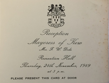
Document (item) - Entrée Card to a Reception in the Kew Recreation Hall, City of Kew, 1949
The Municipality of Kew (1860-1863), the Borough of Kew (1863-1910), the Town of Kew (1910-1921) and the City of Kew (1921-1994) were local government instrumentalities in the State of Victoria. In 1994, the City of Kew was amalgamated, together with the former Cities of Camberwell and Hawthorn, into the new City of Boroondara (1994- ). Like other local government entities of the period, Kew was administered by town clerks. The two notable town clerks in Kew's history were H. H. (Henry Hirst) Harrison (1868-1955) and W. D. (William Dickie) Birrell (1899-1974). Harrison was appointed to the position in 1901 and retired in 1938 after 37 years. Birrell, appointed Acting Town Clerk in 1921, became Town Clerk in 1938, following Harrison's retirement. He continued in this role until his retirement in 1966. A large part of this collection of civic ephemera was assembled by W. D. Birrell. This is part of an historically significant civic collection, containing hundreds of separate invitations, documents, greeting cards, programmes and tickets issued and/or collected by successive town clerks. Items in the collection illuminate the political, social and cultural history of the district. As a continuous record, ranging across most decades of the Twentieth Century, they reveal changing tastes in design, values and relationships in the history of local government in Victoria.ephemera, civic ephemera, civic invitations, city of kew, mrs f w dods, recreation hall -- kew (vic.), receptions -
 Kew Historical Society Inc
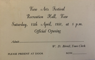
Document (item) - Entrée Card to the Kew Arts Festival, City of Kew, 1950
The Municipality of Kew (1860-1863), the Borough of Kew (1863-1910), the Town of Kew (1910-1921) and the City of Kew (1921-1994) were local government instrumentalities in the State of Victoria. In 1994, the City of Kew was amalgamated, together with the former Cities of Camberwell and Hawthorn, into the new City of Boroondara (1994- ). Like other local government entities of the period, Kew was administered by town clerks. The two notable town clerks in Kew's history were H. H. (Henry Hirst) Harrison (1868-1955) and W. D. (William Dickie) Birrell (1899-1974). Harrison was appointed to the position in 1901 and retired in 1938 after 37 years. Birrell, appointed Acting Town Clerk in 1921, became Town Clerk in 1938, following Harrison's retirement. He continued in this role until his retirement in 1966. A large part of this collection of civic ephemera was assembled by W. D. Birrell. This is part of an historically significant civic collection, containing hundreds of separate invitations, documents, greeting cards, programmes and tickets issued and/or collected by successive town clerks. Items in the collection illuminate the political, social and cultural history of the district. As a continuous record, ranging across most decades of the Twentieth Century, they reveal changing tastes in design, values and relationships in the history of local government in Victoria.ephemera, civic ephemera, civic invitations, city of kew, mrs f w dods, recreation hall -- kew (vic.), receptions -
 Kew Historical Society Inc
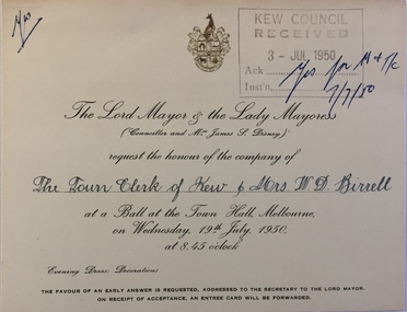
Document (item) - Invitation to a Ball in the Melbourne Town Hall, City of Melbourne, 1950
The Municipality of Kew (1860-1863), the Borough of Kew (1863-1910), the Town of Kew (1910-1921) and the City of Kew (1921-1994) were local government instrumentalities in the State of Victoria. In 1994, the City of Kew was amalgamated, together with the former Cities of Camberwell and Hawthorn, into the new City of Boroondara (1994- ). Like other local government entities of the period, Kew was administered by town clerks. The two notable town clerks in Kew's history were H. H. (Henry Hirst) Harrison (1868-1955) and W. D. (William Dickie) Birrell (1899-1974). Harrison was appointed to the position in 1901 and retired in 1938 after 37 years. Birrell, appointed Acting Town Clerk in 1921, became Town Clerk in 1938, following Harrison's retirement. He continued in this role until his retirement in 1966. A large part of this collection of civic ephemera was assembled by W. D. Birrell. This is part of an historically significant civic collection, containing hundreds of separate invitations, documents, greeting cards, programmes and tickets issued and/or collected by successive town clerks. Items in the collection illuminate the political, social and cultural history of the district. As a continuous record, ranging across most decades of the Twentieth Century, they reveal changing tastes in design, values and relationships in the history of local government in Victoria.ephemera, civic ephemera, civic invitations, city of melbourne, melbourne town hall, cr james s disney, w d birrell -
 Kew Historical Society Inc
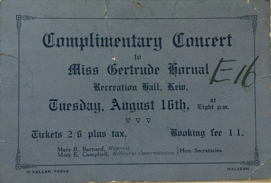
Document (item) - Ticket for a Complimentary Concert in the Kew Recreation Hall, City of Kew, 1921
The Municipality of Kew (1860-1863), the Borough of Kew (1863-1910), the Town of Kew (1910-1921) and the City of Kew (1921-1994) were local government instrumentalities in the State of Victoria. In 1994, the City of Kew was amalgamated, together with the former Cities of Camberwell and Hawthorn, into the new City of Boroondara (1994- ). Like other local government entities of the period, Kew was administered by town clerks. The two notable town clerks in Kew's history were H. H. (Henry Hirst) Harrison (1868-1955) and W. D. (William Dickie) Birrell (1899-1974). Harrison was appointed to the position in 1901 and retired in 1938 after 37 years. Birrell, appointed Acting Town Clerk in 1921, became Town Clerk in 1938, following Harrison's retirement. He continued in this role until his retirement in 1966. A large part of this collection of civic ephemera was assembled by W. D. Birrell. This is part of an historically significant civic collection, containing hundreds of separate invitations, documents, greeting cards, programmes and tickets issued and/or collected by successive town clerks. Items in the collection illuminate the political, social and cultural history of the district. As a continuous record, ranging across most decades of the Twentieth Century, they reveal changing tastes in design, values and relationships in the history of local government in Victoria.Seat "E16"ephemera, civic ephemera, civic invitations, city of kew, recreation hall -- kew (vic.), mary r barnard, mayoresses of kew -
 Kew Historical Society Inc
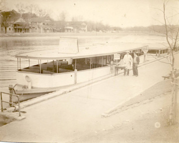
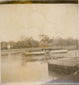
Photograph - Hicks Bros Launch at Princess Walk, circa 1953
Commercially-operated boat tours on the Maribyrnong and Yarra Rivers in Melbourne were a major tourist attraction, especially in the first half of the twentieth century. A number of companies ran ferries and motor-launches to locations such as the Riverview Tea Gardens (1909-1947) at Ascot Vale, and the Hawthorn Tea Gardens on the corner of Power Street and Riversdale Road. One of the families which ran these services was Hicks Bros, which from circa 1921 operated a ferry service from Princess Walk (Melbourne) to Studley Park. This is one of a series of 17 black and white undated photographic proofs donated to the Kew Historical Society in 2013 by the Queenscliffe Historical Museum. The series includes images of individuals, tea rooms, ferries, motor launches, ocean liners and tugs. In 1953, the owner of Hicks Bros was involved in an inquest into the drowning of a Ukrainian tourist on a ferry operated by Melbourne Ferries, a rival firm. In published reports of the inquest, reference is made to a number of photographs taken by Robert Irvine Atchison, part-owner of Hicks Bros. As the reverse of the photographs indicates copyright is held by the State of Victoria, the collection may have derived from that year.Historically significant and rare image of one of the major tour boat services which operated on the Yarra River.Faded black and white photographic proof of a ferry owned by Hicks Bros on the River Yarra at Princess Walk. Two employees stand beside the first of a number of wooden ferries. On the south side of the river, there are the pavilions of a number of boat clubs.ferries, motor launches, yarra river, maribyrnong river, studley park, princess walk, riverview tea gardens, hawthorn tea gardens, tourism - melbourne (vic.), hicks bros, hicks bros launches -
 Kew Historical Society Inc
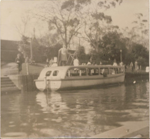
Photograph - Motor launch at Princess Walk, circa 1953
Commercially-operated boat tours on the Maribyrnong and Yarra Rivers in Melbourne were a major tourist attraction, especially in the first half of the twentieth century. A number of companies ran ferries and motor-launches to locations such as the Riverview Tea Gardens (1909-1947) at Ascot Vale, and the Hawthorn Tea Gardens on the corner of Power Street and Riversdale Road. One of the families which ran these services was Hicks Bros, which from circa 1921 operated a ferry service from Princess Walk (Melbourne) to Studley Park. This is one of a series of 17 black and white undated photographic proofs donated to the Kew Historical Society in 2013 by the Queenscliffe Historical Museum. The series includes images of individuals, tea rooms, ferries, motor launches, ocean liners and tugs. In 1953, the owner of Hicks Bros was involved in an inquest into the drowning of a Ukrainian tourist on a ferry operated by Melbourne Ferries, a rival firm. In published reports of the inquest, reference is made to a number of photographs taken by Robert Irvine Atchison, part-owner of Hicks Bros. As the reverse of the photographs indicates copyright is held by the State of Victoria, the collection may have derived from that year.Historically significant and rare image of one of the major tour boat services which operated on the Yarra River.Faded black and white photographic positive proof of a moto launch (tourist ferry) at Princess Walk. The undated photographic positive was probably taken in the 1950s.tugboats, melbourne, motor launches, ferries, hawthorn tea rooms, hicks bros launches, princess walk, yarra river, tourism, transport -
 Kew Historical Society Inc
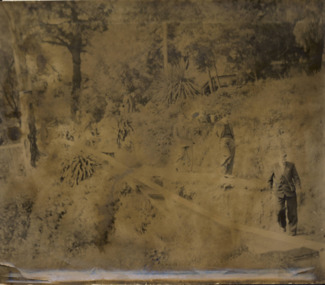
Photograph - Men on the bank of the Yarra River, circa 1953
This is one of a series of 17 black and white undated photographic proofs donated to the Kew Historical Society in 2013 by the Queenscliffe Historical Museum. The series includes images of individuals, tea rooms, ferries, motor launches, ocean liners and tugs. The subject of the photograph is a Hicks Bros ferry, which from circa 1921 operated a ferry service from Princess Walk (Melbourne) to Studley Park.Very faded and degraded photograph of a group of men walking down pathways on the bank of a river in Melbourne. The location may be the Hawthorn Tea Rooms. The undated photographic positive was probably taken in the 1950s.melbourne, tourism -
 Kew Historical Society Inc
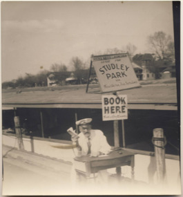
Photograph - Hicks Bros Launch at Princess Walk, circa 1953
Commercially-operated boat tours on the Maribyrnong and Yarra Rivers in Melbourne were a major tourist attraction, especially in the first half of the twentieth century. A number of companies ran ferries and motor-launches to locations such as the Riverview Tea Gardens (1909-1947) at Ascot Vale, and the Hawthorn Tea Gardens on the corner of Power Street and Riversdale Road. One of the families which ran these services was Hicks Bros, which from circa 1921 operated a ferry service from Princess Walk (Melbourne) to Studley Park. This is one of a series of 17 black and white undated photographic proofs donated to the Kew Historical Society in 2013 by the Queenscliffe Historical Museum. The series includes images of individuals, tea rooms, ferries, motor launches, ocean liners and tugs. In 1953, the owner of Hicks Bros was involved in an inquest into the drowning of a Ukrainian tourist on a ferry operated by Melbourne Ferries, a rival firm. In published reports of the inquest, reference is made to a number of photographs taken by Robert Irvine Atchison, part-owner of Hicks Bros. As the reverse of the photographs indicates copyright is held by the State of Victoria, the collection may have derived from that year.Historically significant and rare image of one of the major tour boat services which operated on the Yarra River.Faded black and white photographic proof of a ferry owned by Hicks Bros on the River Yarra at Princess Walk. The ferry has signage confirming the company (Hicks Bros Launches) and the destinations (Studley Park, Hawthorn Tea Rooms). A man, probably Robert Atchison, co-owner of the ferry service, in a captain's hat is selling tickets. Above the roof line of the ferry can be seen the boat houses on the opposite bank. ferries, motor launches, yarra river, maribyrnong river, studley park, princess walk, riverview tea gardens, hawthorn tea gardens, tourism - melbourne (vic.), hicks bros, hicks bros launches -
 Kew Historical Society Inc
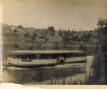
Photograph - Ferry on the Yarra River, circa 1953
Commercially-operated boat tours on the Maribyrnong and Yarra Rivers in Melbourne were a major tourist attraction, especially in the first half of the twentieth century. A number of companies ran ferries and motor-launches to locations such as the Riverview Tea Gardens (1909-1947) at Ascot Vale, and the Hawthorn Tea Gardens on the corner of Power Street and Riversdale Road. One of the families which ran these services was Hicks Bros, which from circa 1921 operated a ferry service from Princess Walk (Melbourne) to Studley Park. This is one of a series of 17 black and white undated photographic proofs donated to the Kew Historical Society in 2013 by the Queenscliffe Historical Museum. The series includes images of individuals, tea rooms, ferries, motor launches, ocean liners and tugs. In 1953, the owner of Hicks Bros was involved in an inquest into the drowning of a Ukrainian tourist on a ferry operated by Melbourne Ferries, a rival firm. In published reports of the inquest, reference is made to a number of photographs taken by Robert Irvine Atchison, part-owner of Hicks Bros. As the reverse of the photographs indicates copyright is held by the State of Victoria, the collection may have derived from that year.Historically significant and rare image of one of the major tour boat services which operated on the Yarra River.Faded black and white photographic proof of a ferry, possibly one of a number owned by Hicks Bros on the River Yarra. The single storey wooden ferry has a wheel that is motor driven. The popularity of ferry services is indicated by the number of passengers on board.ferries, motor launches, yarra river, studley park, princess walk, hawthorn tea gardens, tourism - melbourne (vic.), hicks bros, hicks bros launches -
 Kew Historical Society Inc
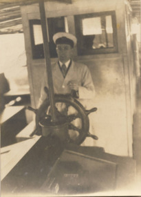
Photograph - Hicks Bros Motor Launch, circa 1953
Commercially-operated boat tours on the Maribyrnong and Yarra Rivers in Melbourne were a major tourist attraction, especially in the first half of the twentieth century. A number of companies ran ferries and motor-launches to locations such as the Riverview Tea Gardens (1909-1947) at Ascot Vale, and the Hawthorn Tea Gardens on the corner of Power Street and Riversdale Road. One of the families which ran these services was Hicks Bros, which from circa 1921 operated a ferry service from Princess Walk (Melbourne) to Studley Park. This is one of a series of 17 black and white undated photographic proofs donated to the Kew Historical Society in 2013 by the Queenscliffe Historical Museum. The series includes images of individuals, tea rooms, ferries, motor launches, ocean liners and tugs. In 1953, the owner of Hicks Bros was involved in an inquest into the drowning of a Ukrainian tourist on a ferry operated by Melbourne Ferries, a rival firm. In published reports of the inquest, reference is made to a number of photographs taken by Robert Irvine Atchison, part-owner of Hicks Bros. As the reverse of the photographs indicates copyright is held by the State of Victoria, the collection may have derived from that year.Historically significant and rare image of one of the major tour boat services which operated on the Yarra River.Faded black and white photographic proof of worker of a ferry service, steering a ferry on the Yarra River. He wears a captain's peaked hat and a coat.ferries, motor launches, yarra river, studley park, princess walk, hawthorn tea gardens, tourism - melbourne (vic.), hicks bros, hicks bros launches -
 Kew Historical Society Inc
Photograph - Ferry on the Yarra River, circa 1953
Commercially-operated boat tours on the Maribyrnong and Yarra Rivers in Melbourne were a major tourist attraction, especially in the first half of the twentieth century. A number of companies ran ferries and motor-launches to locations such as the Riverview Tea Gardens (1909-1947) at Ascot Vale, and the Hawthorn Tea Gardens on the corner of Power Street and Riversdale Road. One of the families which ran these services was Hicks Bros, which from circa 1921 operated a ferry service from Princess Walk (Melbourne) to Studley Park. This is one of a series of 17 black and white undated photographic proofs donated to the Kew Historical Society in 2013 by the Queenscliffe Historical Museum. The series includes images of individuals, tea rooms, ferries, motor launches, ocean liners and tugs. In 1953, the owner of Hicks Bros was involved in an inquest into the drowning of a Ukrainian tourist on a ferry operated by Melbourne Ferries, a rival firm. In published reports of the inquest, reference is made to a number of photographs taken by Robert Irvine Atchison, part-owner of Hicks Bros. As the reverse of the photographs indicates copyright is held by the State of Victoria, the collection may have derived from that year.Historically significant and rare image of one of the major tour boat services which operated on the Yarra River.Faded black and white photographic proof of a ferry, possibly one of a number owned by Hicks Bros on the River Yarra. The single storey wooden ferry has a wheel that is motor driven. The popularity of ferry services is indicated by the number of passengers on board.ferries, motor launches, yarra river, studley park, princess walk, hawthorn tea gardens, tourism - melbourne (vic.), hicks bros, hicks bros launches -
 Kew Historical Society Inc
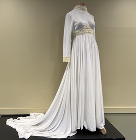
Clothing - Wedding dress, The House of Franke, Stuart, c.1975
At 5pm on 2 May 1975 at Christ Church, Hawthorn, the wedding took place between Kathryn Gwynn Marx of Mason Street, Hawthorn, and William Peter Reeve of Mountain Grove, Kew. The bride's dress was purchased from the 'House of Franke, Stuart', 612 Glenferrie Road, Hawthorn, a very popular place in the 1970s for brides. Kathryn was educated at Ruyton Girls' School with Margaret Franke so it was a nice connection. Margaret's family business had been in operation since 1926. I loved my wedding dress. It was soft and comfortable to wear and kept me warm on the May evening. It was elegant and I knew I would never get the chance to wear something with a long train again. Walking down the staircase at the Windsor Hotel in Melbourne felt very grand; a memory I still hold today. (Kate Reeve, 2022) [Note: Two photos and a newspaper article which are viewable in the image carousel are held in the donation file]Strong local provenance to Hawthorn, Kew and Boroondara due to owner and retailer. It is a representative example of wedding dresses sold in the 1970s. The wedding dress is made of fine soft white jersey with guipure lace around the neckline, wrists and bodice. The long train has three small discreet loops along the hemline which can be slipped onto a finger for a draped effect giving ease of movement for dancing etc. A satin trimmed veil covered the length of the train and was secured on the head with a satin coronet. White leather shoes were worn. The bouquet Phalaenopsis orchids. (Note: the veil and shoes were not part of the donation)Label: Franke Stuart / Hawthornfashion & design - 1970s, wedding dresses, kate reeve, peter reeve, franke stuart, retailers - glenferrie road - hawthorn (vic.) -
 Kew Historical Society Inc
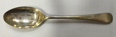
Award, Boroondara Rifle Club Spoon Competition : 800, 900 yds won by J S Penrose 1905, 1905
In 2000, three silver trophy spoons were donated to the Kew Historical Society by the National Trust (Victoria). At the time, the trophies were believed to have been awarded to J.S. Penrose for victories in events held by the Boroondara R.C. [Rifle Club] in 1905 and 1906. The Boroondara Rifle Club was a separate entity to the Kew and Hawthorn Rifle Clubs. The first reference to the Club on Trove is on 11 April 1900, when the Club was established and the committee elected. It is recorded that: “the adjourned meeting in connection with the Boroondara Rifle Club was held in the shire hall on Monday evening; Mr. A. J. Smith, J.P., in the chair. It was decided that the name of the club should be the Boroondara Rifle Club, and that it should embrace the whole shire, with butts at some convenient and accessible spot. A number of additional members were sworn in, making the total enrolled to date about 70. The following gentlemen were elected as office bearers: — President, Sir Frederick Sargood. M.L.C.: vice-presidents, Messrs. Wm. Knox, M.L.C.; F. Madden, M.L.A., and A. J. Smith (president of the shire); hon. captain, Mr. John Mc Whae (chairman of the Stock Exchange) ; committee. Messrs. T. W. Gaggin, J. B. Gilfillan, Cr. Lewis. Cr. Rooks and Cr. Beckett; hon. treasurer. Mr. G. A. Darling; hon. secretary, Mr. A. J. .Macarthur”.The last recorded meeting of the Rifle Club was in 1916, at “Adam’s Hall, upper Hawthorn” when a new committee was elected. Silver trophy spoon awarded to J.S. Penrose by the Boroondara Rifle Club for a victory in the Spoon Competition.Boroondara R.C. / Spoon Competition / 800, 900 yds /won by J.S. Penrose. Score 70 / 21-10-05boroondara rifle club, silver trophies -
 Kew Historical Society Inc
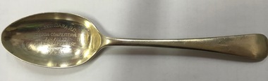
Award, Boroondara Rifle Club Spoon Competition : 200, 300 yds won by J S Penrose 1906, 11/02/1906
In 2000, three silver trophy spoons were donated to the Kew Historical Society by the National Trust (Victoria). At the time, the spoons were believed to have been awarded to J.S. Penrose for victories in events held by the Boroondara R.C. [Rifle Club] in 1905 and 1906. The Boroondara Rifle Club was a separate entity to the Kew and Hawthorn Rifle Clubs. The first reference to the Club on Trove is on 11 April 1900, when the Club was established and the committee elected. It is recorded that: “the adjourned meeting in connection with the Boroondara Rifle Club was held in the shire hall on Monday evening; Mr. A. J. Smith, J.P., in the chair. It was decided that the name of the club should be the Boroondara Rifle Club, and that it should embrace the whole shire, with butts at some convenient and accessible spot. A number of additional members were sworn in, making the total enrolled to date about 70. The following gentlemen were elected as office bearers: — President, Sir Frederick Sargood. M.L.C.: vice-presidents, Messrs. Wm. Knox, M.L.C.; F. Madden, M.L.A., and A. J. Smith (president of the shire); hon. captain, Mr. John McWhae (chairman of the Stock Exchange) ; committee. Messrs. T. W. Gaggin, J. B. Gilfillan, Cr. Lewis. Cr. Rooks and Cr. Beckett; hon. treasurer. Mr. G. A. Darling; hon. secretary, Mr. A. J. Macarthur”. The last recorded meeting of the Rifle Club was in 1916, at “Adam’s Hall, upper Hawthorn” when a new committee was elected. Engraved silver trophy spoon awarded to S.J Penrose by the Boroondara Rifle Club for a victory in the Spoon Competition of 1906Boroondara Rifle Club / Spoon Competition / 200, 300 yds / Won by S.J. Penrose / 11-2-06boroondara rifle club, j.s. penrose, sport, shooting, trophy, a. j. smith, frederick sargood, william knox, f. madden, a. j. smith, john mcwhae, t. w. gaggin, j. b. gilfillan, lewis, rooks, beckett; g. a. darling; a. j. macarthur -
 Kew Historical Society Inc
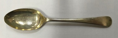
Award, Boroondara Rifle Club Spoon Competition : 500, 600 yds won by J S Penrose 1906, 1906
In 2000, three silver trophy spoons were donated to the Kew Historical Society by the national Trust (Victoria). At the time, the spoons were believed to have been awarded to J.S. Penrose for victories in events held by the Boroondara R.C. [Rifle Club] in 1905 and 1906. The Boroondara Rifle Club was a separate entity to the Kew and Hawthorn Rifle Clubs. The first reference to the Club on Trove is on 11 April 1900, when the Club was established and the committee elected. It is recorded that: “the adjourned meeting in connection with the Boroondara Rifle Club was held in the shire hall on Monday evening; Mr. A. J. Smith, J.P., in the chair. It was decided that the name of the club should be the Boroondara Rifle Club, and that it should embrace the whole shire, with butts at some convenient and accessible spot. A number of additional members were sworn in, making the total enrolled to date about 70. The following gentlemen were elected as office bearers: — President, Sir Frederick Sargood. M.L.C.: vice-presidents, Messrs. Wm. Knox, M.L.C.; F. Madden, M.L.A., and A. J. Smith (president of the shire); hon. captain, Mr. John Mc Whae (chairman of the Stock Exchange) ; committee. Messrs. T. W. Gaggin, J. B. Gilfillan, Cr. Lewis. Cr. Rooks and Cr. Beckett; hon. treasurer. Mr. G. A. Darling; hon. secretary, Mr. A. J. .Macarthur”. The last recorded meeting of the Rifle Club was in 1916, at “Adam’s Hall, upper Hawthorn” when a new committee was elected. Silver trophy awarded to J.S Penrose by the Boroondara Rifle Club for a victory in the Spoon Competition of 1906Boroondara R.C. / Spoon Competition / 500, 600 yds / Won by J.S. Penrose / 4-8-06sports trophies, boroondara rifle club, j s penrose -
 Kew Historical Society Inc
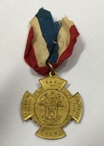
Medal, Stokes & Sons, Town of Kew : To Commemorate its Jubilee, 1910
Medal issued to commemorate the 50th jubilee of the Town of Kew. It names J.F. McCrea as Mayor. John Falding McCrea was Mayor of Kew 1910-11. Kew was proclaimed a municipality on 22 December 1860, seceding from the Boroondara Road Board District, then comprising Kew, Hawthorn and Camberwell. It was proclaimed a town on 8 December 1910, the year this medal was issued, and a city on 10 March 1921. On 22 June 1994 Kew city was united with Camberwell and Hawthorn cities to form Boroondara city.Mint gilt medal with original ribbon.Kew Jubilee medal in the shape of a Maltese cross. Gilded bronze with attached original red, white and blue cloth ribbon. On the front is the Coat of Arms of the Town of Kew and an inscription: ‘Town of Kew. To Commemorate Its Jubilee 1910’. On the reverse is inscribed 'Kew Jubilee 1860-1910. Cr J.F. McCrae J.P. Mayor'. The medal was also issued in bronze.Obverse description Shield of six wheat-sheafs above motto CRESCO on ribbon; above shield is the Royal coat of arms with lion and unicorn supporters and, on ribbon DIEU ET MIN DROIT; on arms of cross top, TOWN / OF, bottom, KEW, left TO COMMEM / -ORATE, right, ITS JUBILEE / 1910 Reverse description Within line circle set at centre of cross shaped flan, CR. J.F. McCREA / J.P. / MAYOR on arms of cross, top, KEW bottom, JUBILEE, left 1860, right, 1910jubilee - kew (vic), commemorative medals - kew (vic), australian commemorative medals -
 Kew Historical Society Inc
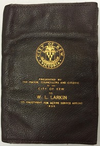
Functional object - Presentation Wallet, City of Kew, 1939, 1939
William 'Bill' Leo Larkin (b. 19.09.1898) was born in Hawthorn (Vic). [His World War I enlistment papers give details of the Hawthorn birthdate, as well as Ballarat, but his birth records state his birth as Hawthorn). After leaving St Patrick's College in Ballarat in 1917, he enlisted in the army serving in England and France. At the time of his enlistment in the army in the Second World War (17 April 1940), he was recorded as living in Kew. His service number was VX11459. The Sands & McDougall Directory of 1938 gives his address as 31 Fernhurst Grove. In the army he served in the Middle East and in New Guinea. He was to attain the rank of Lieutenant Colonel in 1942. He was made an Officer of the Order of the British Empire (O.B.E) in 1946. Enlistment Presentation Wallets were presented by the City of Kew from 1940 to men who enlisted in the war. Typically, these wallets are dated 1939, even though the enlistment may have occurred at a later date.Memento presented to citizens of Kew (vic.) on enlistmentRectangular brown leather single fold wallet with eight internal pockets. The front includes an embossed City of Kew logo and the words ‘Presented by the Mayor, Councillors and Citizens of the City of Kew to W. L. Larkin on Enlistment for Active Service Abroad, 1939'.second world war 1939-1945, world war two, city of kew, william leo larkin, bill larkin, presentation wallets -
 Kew Historical Society Inc
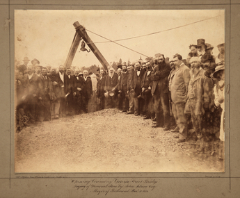
Photograph, Opening Ceremony Victoria Street Bridge: Laying of memorial stone by John Adam Esq. Mayor of Richmond, 1884
A formal group photograph of the grand opening of the Victoria Street Bridge on March 31 1884. The Argus was to report that: ‘The ceremony of laying the memorial stone of the Victoria-bridge, which connects Kew and Hawthorn with Richmond and Collingwood, was performed yesterday afternoon by the mayor of Richmond (Mr John Adam) in the presence of a large assemblage. Among the gentlemen present at yesterday’s proceedings were the mayor of Collingwood (Mr. M. Dwyer), the Mayor of Melbourne (Councillor C. Smith, M.L. A.) the mayor of Kew (Mr. Barnard), Mr. J. A. B. Koch and Mr. W. W. Shelley (ex mayors of Richmond), Mr. Joseph Bosisto, M.L.A., the Hon. L. L. Smith, Councillor De Mole (ex mayor of Kew), Mr. Jas. Lancashire and Mr. Winter (ex mayors of Ricmond), Mr. Walker (ex mayors of Collingwood), Mr. Johnson (engineer), Mr. C. Rowan, C.E. (engineer of the bridge alterations) and the town clerks of Richmond, Collingwood and Kew.’ Following the opening ceremony ‘… a ponderous steam roller was driven over the structure, with a view to test, or rather to demonstrate its stability … Most of the gentlemen present walked over the bridge, after which they were grouped by a photographer, with the memorial stone as a central feature, and several views of the scene were taken’.An original, rare silver albumen mounted and titled photograph of an important event in 19th century Melbourne.Original photograph mounted on display card of the opening of the Victoria Street Bridge. The original photograph is very faded and has been enhanced to improve the image's viewability.On the reverse of the card is an indecipherable stamp and an inscription identifying the photographers. "T. W. & C. A. McAlpine Bros, Photographers &., Campbell Parade East Richmond Melbourne March 31.1884victoria street bridge, john adam, m. dwyer, c. smith, barnard, j.a.b. koch, w.w. shelley, bridge, kew, collingwood, l.l. smith, joseph bosisto -
 Kew Historical Society Inc
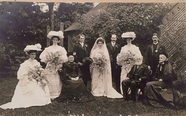
Photograph - Harrison-Balfour Wedding Party, 1905
This wedding photograph is an illustration of the intermarriage of notable Victorian (and Kew) families. The parents of the groom were the Hon. James Balfour MP., and his wife, Frances Charlotte (Henty) [the eldest daughter of James Henty] who married at Hawthorn in 1859. The Balfour lived at 'Windella' in Studley Park Road. Henry Rairey (Harry) Balfour was the youngest son of Mr & Mrs Balfour who married Katie Harrison of 'Horley' in Molesworth Street, Kew. Miss Harrison's father was the T.S. Harrison (merchant and importer, b. Banbury, Oxon, 1829, d. Melb 1901). Portrait of the wedding party in the garden of Horley in Molesworth Street, following the marriage of Elizabeth Kate (Katie) Harrison to Henry Rairey (Harry) Balfour at the Kew Presbyterian Church in 1905. The outfits worn by the women were reported in Punch, on 9 February 1905]. The bride wore a frock of ivory white satin, with bertha of duchesse lace and a yoke of ruched chiffon. The bridesmaids … wore white muslin dresses, inserted with Valenciennes, made in early Victorian style. The white straw hats were trimmed with lace and blue hydrangea, and their flowers were blue hydrangea, delphiniums and cornflowers. … The bride’s mother [right] wore a well-cut dress of black silk. The bridegroom’s mother [left] wore a gown of black silk voile, and smart black bonnet grouped with roses. L. to R. Christian Balfour, Jean Mackintosh, Mrs James Balfour (nee Henty), Bridegroom, Bride, Dr. Lewis Balfour, Genevieve Harrison, Hon. James Balfour, Henry Harvey, Marion Harrison (nee Borodin) [Married by Mr Alec Scholes at Kew Presbyterian Church] .Individuals identified in ink on reverse plus donor name and date.balfour, henty, harrison, horley, molesworth street, kew -
 Kew Historical Society Inc
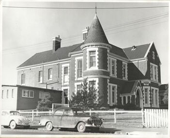
Photograph, Kew RSL, Cotham Road, circa 1965, c. 1965
The Kew RSL is located in "Wilton" House, 63 Cotham Road. The RSL was established on January 1st 1920, later joining with the Hawthorn RSL. In November 1931, Cr. C.R. Parry organised the reformation of the Kew Sub Branch and its first president was Brig-Gen Pat McGlin, a veteran of the Boer War and the First World War. On July 17th 1932, the club rooms first opened on Army land at the corner of High Street and Highbury Grove. In late November 1948, the Kew RSL bought the "Wilton" house from the Kew City Council for £10,067, opening seven years later in July 1955. [Source: Victorian Heritage Database]This work forms part of the collection assembled by the historian Dorothy Rogers, that was donated to the Kew Historical Society by her son John Rogers in 2015. The manuscripts, photographs, maps, and documents were sourced by her from both family and local collections or produced as references for her print publications. Many were directly used by Rogers in writing ‘Lovely Old Homes of Kew’ (1961) and 'A History of Kew' (1973), or the numerous articles on local history that she produced for suburban newspapers. Most of the photographs in the collection include detailed annotations in her hand. The Rogers Collection provides a comprehensive insight into the working habits of a historian in the 1960s and 1970s. Together it forms the largest privately-donated collection within the archives of the Kew Historical Society.The exterior of the Kew RSL on the corner of Cotham Road and Charles Street, Kew. Designed by Guyon Purchase for Dr. William Walsh in 1886, the building was originally called Wilton."Chap 59. Cotham Rd. Built/Commences about 1885-6. Present day Wilton . Kew RSSUILA rooms. (Rumour of sale 1972?)"wilton, dr william walsh, guyon purchas, dorothy rogers, cotham road (kew) -
 Kew Historical Society Inc
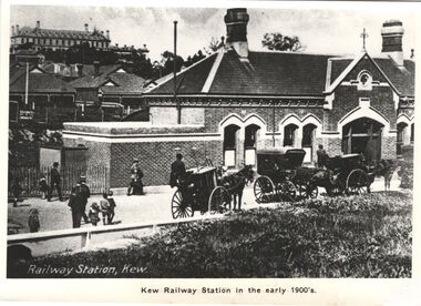
Print, Kew Railway Station in the early 1900s
Kew Railway Station (1887-1959). ‘Kew Railway Station’ in Denmark Street was the terminus of the Kew Line, which extended from Hawthorn Station to just south of Wellington Street. The Station opened on 19 December 1887 after a prolonged campaign for a railway by the people of Kew. Due to a decline in patronage, the passenger service ceased operations in August 1952. While a freight service continued for another five years, the line and station were officially closed on 13 May 1957. Subsequently demolished in 1959, the headquarters of VicRoads (formerly Country Roads Board) now stands on the former Station site.This work forms part of the collection assembled by the historian Dorothy Rogers, that was donated to the Kew Historical Society by her son John Rogers in 2015. The manuscripts, photographs, maps, and documents were sourced by her from both family and local collections or produced as references for her print publications. Many were directly used by Rogers in writing ‘Lovely Old Homes of Kew’ (1961) and 'A History of Kew' (1973), or the numerous articles on local history that she produced for suburban newspapers. Most of the photographs in the collection include detailed annotations in her hand. The Rogers Collection provides a comprehensive insight into the working habits of a historian in the 1960s and 1970s. Together it forms the largest privately-donated collection within the archives of the Kew Historical Society.A photographic copy of a book plate from 'Kew's Civic Century' (1960) by W.D. Vaughan. The book plate was itself a copy of an early 20th century postcard depicting the Kew Railway Station."Railway opened 1887 - Then as photo states"kew railway station, dorothy rogers, country roads board, vicroads -
 Kew Historical Society Inc
Plan, Studley Park Estate, 1910
Prue Sanderson, in her groundbreaking ‘City of Kew Urban Conservation Study : Volume 2 - Development History’ (1988), summarised the periods of urban development and subdivisions of land in Kew. The periods that she identified included 1845-1880, 1880-1893, 1893-1921, 1921-1933, 1933-1943, and Post-War Development. These periods were selected as they represented periods of rapid growth or decline in urban development. An obvious starting point for Sanderson’s groupings involved population growth and the associated economic cycles. These cycles also highlighted urban expansion onto land that was predominantly rural, although in other cases it represented the decline and breakup of large estates. A number of the plans in the Kew Historical Society’s collection can also be found in other collections, such as those of the State Library of Victoria and the Boroondara Library Service. A number are however unique to the collection.The Kew Historical Society collection includes almost 100 subdivision plans pertaining to suburbs of the City of Melbourne. Most of these are of Kew, Kew East or Studley Park, although a smaller number are plans of Camberwell, Deepdene, Balwyn and Hawthorn. It is believed that the majority of the plans were gifted to the Society by persons connected with the real estate firm - J. R. Mathers and McMillan, 136 Cotham Road, Kew. The Plans in the collection are rarely in pristine form, being working plans on which the agent would write notes and record lots sold and the prices of these. The subdivision plans are historically significant examples of the growth of urban Melbourne from the beginning of the 20th Century up until the 1980s. A number of the plans are double-sided and often include a photograph on the reverse. A number of the latter are by noted photographers such as J.E. Barnes.Coloured lithograph of a subdivision plan of the Studley Park Estate, bordered by Yarra, Willsmere Road and the Outer Circle Railway line. The estate was listed in 1910 and was the subject of a planning dispute between the developer and the Town of Kew in relation to flood levels and the suitability of the land for housing. In many cases the names of streets were subsequently changed. The layout was also affected by the creation of the Eastern Freeway. A newspaper report of the day described the subdivision as a: "GOLDEN OPPORTUNITY. We are pleased to submit for PRIVATE SALE that magnificent ESTATE, situated only 4 1/2 miles from the Melbourne General Post Office, STUDLEY PARK ESTATE. KF/NV. Doubtless the CHEAPEST LAND EVER OFFERED having extensive frontages to the prettiest spot on the River Yarra and the National Park, commanding lovely river and landscape views, and acknowledged to be the finest land available so close to the city. The PRICES ARE EXTREMELY MODERATE; The TERMS ARE SIMPLY MARVELLOUS. NO DEPOSIT. NO DEPOSIT. NO DEPOSIT. Allotments and prices to suit everyone."subdivision plans - kew, studley park estate -
 Kew Historical Society Inc
Plan - Subdivision Plan, Goldthorns House Estate, 1940
Pru Sanderson, in her groundbreaking ‘City of Kew Urban Conservation Study : Volume 2 - Development History’ (1988), summarised the periods of urban development and subdivisions of land in Kew. The periods that she identified included 1845-1880, 1880-1893, 1893-1921, 1921-1933, 1933-1943, and Post-War Development. These periods were selected as they represented periods of rapid growth or decline in urban development. An obvious starting point for Sanderson’s groupings involved population growth and the associated economic cycles. These cycles also highlighted urban expansion onto land that was predominantly rural, although in other cases it represented the decline and breakup of large estates. A number of the plans in the Kew Historical Society’s collection can also be found in other collections, such as those of the State Library of Victoria and the Boroondara Library Service. A number are however unique to the collection.The Kew Historical Society collection includes almost 100 subdivision plans pertaining to suburbs of the City of Melbourne. Most of these are of Kew, Kew East or Studley Park, although a smaller number are plans of Camberwell, Deepdene, Balwyn and Hawthorn. It is believed that the majority of the plans were gifted to the Society by persons connected with the real estate firm - J. R. Mathers and McMillan, 136 Cotham Road, Kew. The Plans in the collection are rarely in pristine form, being working plans on which the agent would write notes and record lots sold and the prices of these. The subdivision plans are historically significant examples of the growth of urban Melbourne from the beginning of the 20th Century up until the 1980s. A number of the plans are double-sided and often include a photograph on the reverse. A number of the latter are by noted photographers such as J.E. Barnes.The first subdivision of Goldthorns created the Goldthorns Hill Estate. Following that subdivision, seven additional lots were offered between Normanby Road, Argyle Road and Lady Loch’s Drive on the proviso that the estate, including Goldthorns was not sold as a single lot. The subdivision plan advises that the lots are situated in one of the most charming and popular residential areas in Kew and is surrounded by modern homes. Typically, the subdivision plan proposes the advantage of its proximity to Cotham Road and the tram to Collins Street. Because of the elevation of Goldthorns, much is made of the ‘bright, sunny and extensive outlook to the Northern Ranges’ and that it overlooks the Yarra Valley. One of the more interesting aspects of the plan is that it shows the outline of Goldthorns in the mid to late 1920s. Its profile today remains virtually the same."Goldthorns" House Estate at topsubdivision plans - kew, goldthorns house estate -
 Kew Historical Society Inc
Plan, Sydney Arnold Best & Co, Field Place, Kew, c.1929
Pru Sanderson, in her groundbreaking ‘City of Kew Urban Conservation Study : Volume 2 - Development History’ (1988), summarised the periods of urban development and subdivisions of land in Kew. The periods that she identified included 1845-1880, 1880-1893, 1893-1921, 1921-1933, 1933-1943, and Post-War Development. These periods were selected as they represented periods of rapid growth or decline in urban development. An obvious starting point for Sanderson’s groupings involved population growth and the associated economic cycles. These cycles also highlighted urban expansion onto land that was predominantly rural, although in other cases it represented the decline and breakup of large estates. A number of the plans in the Kew Historical Society’s collection can also be found in other collections, such as those of the State Library of Victoria and the Boroondara Library Service. A number are however unique to the collection.The Kew Historical Society collection includes almost 100 subdivision plans pertaining to suburbs of the City of Melbourne. Most of these are of Kew, Kew East or Studley Park, although a smaller number are plans of Camberwell, Deepdene, Balwyn and Hawthorn. It is believed that the majority of the plans were gifted to the Society by persons connected with the real estate firm - J. R. Mathers and McMillan, 136 Cotham Road, Kew. The Plans in the collection are rarely in pristine form, being working plans on which the agent would write notes and record lots sold and the prices of these. The subdivision plans are historically significant examples of the growth of urban Melbourne from the beginning of the 20th Century up until the 1980s. A number of the plans are double-sided and often include a photograph on the reverse. A number of the latter are by noted photographers such as J.E. Barnes.An unnamed subdivision in Studley Park including five lots for sale in Studley Park Road, Highfield Grove and Tara Avenue. Unidentified on the plan, but clearly existing, are the Henty family mansion of Field Place and Tara Hall in Studley Park Road. The first attempted subdivision of Tara Hall was advertised in 1927 in which Lots 5, 6 and 7 in this plan were also advertised. Unusually, Lot 2 in Studley Park Road was created from the northern part of the Henty mansion, rather than Tara Hall. In the subdivision, lots were advertised at varying prices, with the highest price for land being Lot 2 in Studley Park Road. The plan notes that only one villa is to be allowed on each allotment.subdivision plans - kew, field place subdivision -- studley park – kew (vic.), highfield grove – kew (vic.), tara avenue – kew (vic.) -
 Kew Historical Society Inc
Plan - Subdivision Plan, Altyre Estate, 1920, 1920
Pru Sanderson, in her groundbreaking ‘City of Kew Urban Conservation Study : Volume 2 - Development History’ (1988), summarised the periods of urban development and subdivisions of land in Kew. The periods that she identified included 1845-1880, 1880-1893, 1893-1921, 1921-1933, 1933-1943, and Post-War Development. These periods were selected as they represented periods of rapid growth or decline in urban development. An obvious starting point for Sanderson’s groupings involved population growth and the associated economic cycles. These cycles also highlighted urban expansion onto land that was predominantly rural, although in other cases it represented the decline and breakup of large estates. A number of the plans in the Kew Historical Society’s collection can also be found in other collections, such as those of the State Library of Victoria and the Boroondara Library Service. A number are however unique to the collection.The Kew Historical Society collection includes almost 100 subdivision plans pertaining to suburbs of the City of Melbourne. Most of these are of Kew, Kew East or Studley Park, although a smaller number are plans of Camberwell, Deepdene, Balwyn and Hawthorn. It is believed that the majority of the plans were gifted to the Society by persons connected with the real estate firm - J. R. Mathers and McMillan, 136 Cotham Road, Kew. The Plans in the collection are rarely in pristine form, being working plans on which the agent would write notes and record lots sold and the prices of these. The subdivision plans are historically significant examples of the growth of urban Melbourne from the beginning of the 20th Century up until the 1980s. A number of the plans are double-sided and often include a photograph on the reverse. A number of the latter are by noted photographers such as J.E. Barnes.The Altyre Estate was advertised for sale by auction in 1920. A colour lithograph in the State Library of Victoria, in contrast to this monochrome version, notes the proximity of the subdivision to the Auburn Heights Bowling Club and to a range of transport options. The subdivision included fifty-one allotments as well as the original house ‘Altyre’ in Barkers Road. This version includes the amounts paid as deposit on a number of lots.subdivision plans - kew, altyre estate – kew (vic), barkers road – kew (vic), walsh street – kew (vic), ross street – kew (vic), loxton street – kew (vic), mount street – kew (vic), auburn heights bowling club, altyre -
 Kew Historical Society Inc
Plan - Subdivision Plan, Summerhill Estate, 1920-1940
Pru Sanderson, in her groundbreaking ‘City of Kew Urban Conservation Study : Volume 2 - Development History’ (1988), summarised the periods of urban development and subdivisions of land in Kew. The periods that she identified included 1845-1880, 1880-1893, 1893-1921, 1921-1933, 1933-1943, and Post-War Development. These periods were selected as they represented periods of rapid growth or decline in urban development. An obvious starting point for Sanderson’s groupings involved population growth and the associated economic cycles. These cycles also highlighted urban expansion onto land that was predominantly rural, although in other cases it represented the decline and breakup of large estates. A number of the plans in the Kew Historical Society’s collection can also be found in other collections, such as those of the State Library of Victoria and the Boroondara Library Service. A number are however unique to the collection.The Kew Historical Society collection includes almost 100 subdivision plans pertaining to suburbs of the City of Melbourne. Most of these are of Kew, Kew East or Studley Park, although a smaller number are plans of Camberwell, Deepdene, Balwyn and Hawthorn. It is believed that the majority of the plans were gifted to the Society by persons connected with the real estate firm - J. R. Mathers and McMillan, 136 Cotham Road, Kew. The Plans in the collection are rarely in pristine form, being working plans on which the agent would write notes and record lots sold and the prices of these. The subdivision plans are historically significant examples of the growth of urban Melbourne from the beginning of the 20th Century up until the 1980s. A number of the plans are double-sided and often include a photograph on the reverse. A number of the latter are by noted photographers such as J.E. Barnes.The Summerhill Estate was a subdivision in Glen Iris of 24 ‘choice allotments’. The lots were primarily on both sides of Dillon Grove. Other lots at each end of the subdivision faced Margaret Street and Summerhill Road. It was from the latter that the subdivision took its advertised title. The lots were originally advertised for £10 deposit with 20 subsequent payments over five years. Pencilled on the printed plan is a change to the deposit required; a reduction to 20/-. Annotations indicate that the new deposits ranged from 30/- to 45/-. The most expensive lots faced Summerhill Road. This subdivision plan is unusual in that the front and rear of the card are for subdivisions in different localities.subdivision plans - glen iris, summerhill estate -
 Kew Historical Society Inc
Plan - Subdivision Plan, Old Kew Golf Links Estate - Third Section, 1920-1929
Pru Sanderson, in her groundbreaking ‘City of Kew Urban Conservation Study : Volume 2 - Development History’ (1988), summarised the periods of urban development and subdivisions of land in Kew. The periods that she identified included 1845-1880, 1880-1893, 1893-1921, 1921-1933, 1933-1943, and Post-War Development. These periods were selected as they represented periods of rapid growth or decline in urban development. An obvious starting point for Sanderson’s groupings involved population growth and the associated economic cycles. These cycles also highlighted urban expansion onto land that was predominantly rural, although in other cases it represented the decline and breakup of large estates. A number of the plans in the Kew Historical Society’s collection can also be found in other collections, such as those of the State Library of Victoria and the Boroondara Library Service. A number are however unique to the collection.The Kew Historical Society collection includes almost 100 subdivision plans pertaining to suburbs of the City of Melbourne. Most of these are of Kew, Kew East or Studley Park, although a smaller number are plans of Camberwell, Deepdene, Balwyn and Hawthorn. It is believed that the majority of the plans were gifted to the Society by persons connected with the real estate firm - J. R. Mathers and McMillan, 136 Cotham Road, Kew. The Plans in the collection are rarely in pristine form, being working plans on which the agent would write notes and record lots sold and the prices of these. The subdivision plans are historically significant examples of the growth of urban Melbourne from the beginning of the 20th Century up until the 1980s. A number of the plans are double-sided and often include a photograph on the reverse. A number of the latter are by noted photographers such as J.E. Barnes.When the old Kew Golf Links was subdivided in the mid 1920s, the developers were able to break the sale into sections. The third section included eighty lots. The lots faced Kilby Road, Kodak Avenue, Belford Road, Baker Avenue, Mathers Avenue, and White Avenue. [Kodak Avenue was renamed Page Avenue at a later date].The ‘Kew Conservation Study (1988) notes that ‘On the subdivision plan, Kodak’s involvement is commemorated by the naming of the streets after Company directors, and their decision to not proceed with the construction of the factory is explained as a response to the increase in the value of the land. This explanation may have been Estate Agent’s hyperbole, as the Kodak Company records suggest that the land, with its wide creek gully, was unsuitable and too small for its purposes.subdivision plans - kew, old kew golf links estate - third section -
 Kew Historical Society Inc
Plan - Subdivision Plan, Birdwood Estate, 1920
Pru Sanderson, in her groundbreaking ‘City of Kew Urban Conservation Study : Volume 2 - Development History’ (1988), summarised the periods of urban development and subdivisions of land in Kew. The periods that she identified included 1845-1880, 1880-1893, 1893-1921, 1921-1933, 1933-1943, and Post-War Development. These periods were selected as they represented periods of rapid growth or decline in urban development. An obvious starting point for Sanderson’s groupings involved population growth and the associated economic cycles. These cycles also highlighted urban expansion onto land that was predominantly rural, although in other cases it represented the decline and breakup of large estates. A number of the plans in the Kew Historical Society’s collection can also be found in other collections, such as those of the State Library of Victoria and the Boroondara Library Service. A number are however unique to the collection.The Kew Historical Society collection includes almost 100 subdivision plans pertaining to suburbs of the City of Melbourne. Most of these are of Kew, Kew East or Studley Park, although a smaller number are plans of Camberwell, Deepdene, Balwyn and Hawthorn. It is believed that the majority of the plans were gifted to the Society by persons connected with the real estate firm - J. R. Mathers and McMillan, 136 Cotham Road, Kew. The Plans in the collection are rarely in pristine form, being working plans on which the agent would write notes and record lots sold and the prices of these. The subdivision plans are historically significant examples of the growth of urban Melbourne from the beginning of the 20th Century up until the 1980s. A number of the plans are double-sided and often include a photograph on the reverse. A number of the latter are by noted photographers such as J.E. Barnes.Bordering Burke Road, the Birdwood Estate included a subdivision of 34 lots on either side of Birdwood Street, Balwyn. Six of the lots faced Burke Road. At the other end of the subdivision a line would indicate that a creek once bordered the subdivision. Lots were advertised for sale at a low figure on five-year terms. Purchasers could pay off the balance in twenty quarterly instalments (i.e. over five years).subdivision plans - balwyn, birdwood estate -
 Kew Historical Society Inc
Plan - Subdivision Plan, Mayfield Estate, 1927
A number of the plans in the Kew Historical Society’s collection can also be found in other collections, such as those of the State Library of Victoria. A number are however unique to the collection.The Kew Historical Society collection includes almost 100 subdivision plans pertaining to suburbs of the City of Melbourne. Most of these are of Kew, Kew East or Studley Park, although a smaller number are plans of Camberwell, Deepdene, Balwyn and Hawthorn. It is believed that the majority of the plans were gifted to the Society by persons connected with the real estate firm - J. R. Mathers and McMillan, 136 Cotham Road, Kew. The Plans in the collection are rarely in pristine form, being working plans on which the agent would write notes and record lots sold and the prices of these. The subdivision plans are historically significant examples of the growth of urban Melbourne from the beginning of the 20th Century up until the 1980s. A number of the plans are double-sided and often include a photograph on the reverse. A number of the latter are by noted photographers such as J.E. Barnes.The Mayfield Estate subdivision included 14 allotments surrounding Evan Court (now Evans Court) in Toorak. The subdivision adjoined Toorak Road east of Kooyong Road and alerted prospective buyers to how the Toorak Road tram would take them directly to the city. This emphasis on existing transport routes was a feature of subdivisions during a period when car ownership was the preserve of the wealthy. An existing brick villa (‘Mayfield’) is noted as already constructed on lot 13. The subdivision also notes that the lots adjoin land owned by Sir Edward Miller. Today Evans Court extends beyond this subdivision through to Moonga Road.subdivision plans - toorak, mayfield estate, sir edward miller -
 Kew Historical Society Inc
Plan - Subdivision Plan, Bonnie Doon Estate, c.1908
Pru Sanderson, in her groundbreaking ‘City of Kew Urban Conservation Study : Volume 2 - Development History’ (1988), summarised the periods of urban development and subdivisions of land in Kew. The periods that she identified included 1845-1880, 1880-1893, 1893-1921, 1921-1933, 1933-1943, and Post-War Development. These periods were selected as they represented periods of rapid growth or decline in urban development. An obvious starting point for Sanderson’s groupings involved population growth and the associated economic cycles. These cycles also highlighted urban expansion onto land that was predominantly rural, although in other cases it represented the decline and breakup of large estates. A number of the plans in the Kew Historical Society’s collection can also be found in other collections, such as those of the State Library of Victoria and the Boroondara Library Service. A number are however unique to the collection.The Kew Historical Society collection includes almost 100 subdivision plans pertaining to suburbs of the City of Melbourne. Most of these are of Kew, Kew East or Studley Park, although a smaller number are plans of Camberwell, Deepdene, Balwyn and Hawthorn. It is believed that the majority of the plans were gifted to the Society by persons connected with the real estate firm - J. R. Mathers and McMillan, 136 Cotham Road, Kew. The Plans in the collection are rarely in pristine form, being working plans on which the agent would write notes and record lots sold and the prices of these. The subdivision plans are historically significant examples of the growth of urban Melbourne from the beginning of the 20th Century up until the 1980s. A number of the plans are double-sided and often include a photograph on the reverse. A number of the latter are by noted photographers such as J.E. Barnes.The subdivision advertised as the Bonnie Doon Estate in Greensborough was first advertised in 1908. At that stage, the new subdivision included 15 allotments of between one and four acres. By the time the subdivision plan in the Kew Collection was created, only 12 lots of between ¾ and 2½ acres remained. Both the State Library and Kew plans emphasise the distance to the city being 13½ miles, which could be reached by train on weekdays and weekends. Unusually, the plan describes the suitability of lots as locations for ‘Week-end Homes’. Correspondingly, the train line is described as ‘The Holiday Resort for the Northern Suburbs’.bonnie doona estate, subdivision plans - greensborough