Showing 1301 items
matching height
-
 Melbourne Tram Museum
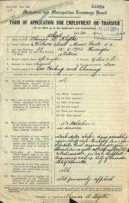
Document - Form/s, Mr. E Westcott, "Form of application for employment or transfer", 30/10/1940 12:00:00 AM
Form - foolscap of a very light blue paper and four quarto ruled sheets attached by staple to a "Form of application for employment or transfer", completed 30/10/1940 and date stamped 31/Oct. 1940" from Thomas A Blythe of Moonee Ponds for the position of "Car Parking and Cleaning". Has space for personal details, address, age, height, marital status, current employment, relatives, details of previous employment, references testimonials, war service. Attached are hand written copies of four testimonials from Nash Motors, Campbell Motor Engineering Works and the City of Essendon Unemployed Relief Committee dated 5-2-1932. No indication as whether he was employed or not.Various hand written notations by the applicant. stamped "86009" in the top right hand corner.trams, tramways, employment forms, personnel, depots, cleaners -
 Marysville & District Historical Society
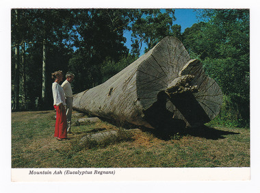
Postcard (item) - Colour postcard, Colorscans (Publishing) Pty Ltd, Mountain Ash (Eucalyptus Regans), Pre 2009
A colour photograph of a felled Mountain Ash tree that was on display in Marysville, Victoria.A colour photograph of a felled Mountain Ash tree that was on display in Marysville, Victoria. This postcard was produced by Colorscans (Publishing) Pty. Ltd. as a souvenir of Marysville.Colorscans C PUBLISHED & PRINTED BY COLORSCANS (PUBLISHING) PTY. LTD. 118 BRIGHTON STREET, RICHMOND 3121 Supa-vu/ cards MARYSVILLE - VICTORIA This Mountain Ash (Eucalyptus/ Regnans) log was felled in 1971/ on Mt. Observation. Total height/ 57.3 metres, age 224 years. Volume/ of this log 1194 super feet suffic-/ ient to frame an average house. Photographed and Distributed by:/ K & H. ELLIS - 35 Old Warburton Road,/ Warburton 3799marysville, mountain ash, eucalyptus regnans, victoria, colorscans publishing, postcard, souvenir -
 Marysville & District Historical Society
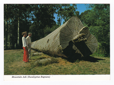
Postcard (item) - Colour postcard, Colorscans (Publishing) Pty Ltd, Mountain Ash (Eucalyptus Regans), Pre 2009
A colour photograph of a felled Mountain Ash tree that was on display in Marysville in Victoria.A colour photograph of a felled Mountain Ash tree that was on display in Marysville in Victoria. This postcard was produced by Colorscans (Publishing) Pty. Ltd. as a souvenir of Marysville.Colorscans C PUBLISHED & PRINTED BY COLORSCANS (PUBLISHING) PTY. LTD. 118 BRIGHTON STREET, RICHMOND 3121 Supa-vu/ cards MARYSVILLE - VICTORIA This Mountain Ash (Eucalyptus/ Regnans) log was felled in 1971/ on Mt. Observation. Total height/ 57.3 metres, age 224 years. Volume/ of this log 1194 super feet suffic-/ ient to frame an average house. Photographed and Distributed by:/ K & H. ELLIS - 35 Old Warburton Road,/ Warburton 3799marysville, mountain ash, eucalyptus regnans, victoria, colorscans publishing, postcard, souvenir -
 National Wool Museum
Textile - Parsons Rolled Oats Bag
These domestic kitchen bags were donated to the National Wool Museum by Lila Gore. Lila donated Children’s Clothing (RGE 8324) to the museum in 2022 and at her time of donating, inquired as to whether the museum would also be interested in these bags she had been collecting. Lila said there was no reason as to why she was saving the bags, other than she liked the art works and thought they were too good to end up in landfill. She had thought perhaps she would make something out of the bags, or perhaps give the bags to a friend to make something. When Lila was donating the Children’s Clothing to the museum, she thought that the National Wool Museum would be the perfect home for the bags. Domestic kitchen bags such as these date from the late 19th century through the mid-20th century. They were used at home, usually by women, containing household items which would not spoil, such as flour, sugar, animal feed, seeds, and other commodities. In modern times a trip to the supermarket is a daily chore, in the past however, these trips happened far less often, with big sacks such as these a large reason why. In the rural US and Canada, Feed sack dresses and Flour sack dresses, were an iconic part of rural life from the 1920s through the Great Depression, World War II, and post-World War II years. Australia also reused these sacks, typically for making wagga style blankets, but re-use for clothing was not unusual.Calico oat bag with colour image and black text. Image shows a full length brown horse with bridle.Front: PARSONS FARM ANIMAL SERIES No.3 \ SUFFOLK \ The Suffolk, often known as the Suffolk Punch, originated in the County of Suffolk, England \ and is noted for its hardiness. From 15 to 16 hands in height. The Suffolk in general is smaller than \ the Clydesdale. The head is rather coarse, with the neck short. The body long deep and wide with \ a round full appearance. The croup is straight and legs short and free from leather. The invariable \ colour is chestnut, varying from light to dark.wagga, flour, oats, bag, calico, lila, gore, depression, war, kitchen -
 Bendigo Military Museum
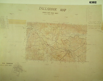
Map - Australian Topographical Survey TALLAROOK SE Sheet, 1 inch:1 Mile, NW portion Plane Table Field sheet 1923, Australian Survey Corps, 1923
This is a coloured reproduction print of an original Plane Table compilation map sheet of Tallarook area 1inch to 1 Mile scale compiled by Sgt Jack Cullen Australian Survey Corps 12 November 1923 and signed by Capt J Lynch. Capt Lynch and Sgt Cullen were both foundation members of the Australian Survey Corps. Of particular interest is the fact that this is a heighted compilation with contouring (required for Military use) as many early maps were purely planimetric. The reverse side of this print is a copy of the Nagambie plane table South West field sheet.Reprinted coloured Image of Australian Topographical Survey TALLAROOK SE field Sheet,1 inch:1 Mile, hand drawn contoured Plane Table Field sheet. Signed by Sgt J Cullen Australian Survey Corps November1923. An enlargement of YEA Township 2 Inches to 1 Mile Scale.royal australian survey corps, rasvy, fortuna, army survey regiment, army svy regt, asr -
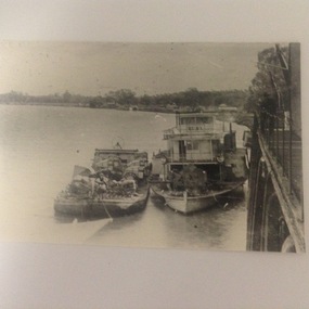 Port of Echuca
Photograph, P.S Ruby at Morgan Wharf, 19-09-1984
The P.S Ruby is possibly the vessel mentioned in "1898 Register of Marine Underwriter's Association of Victoria." ; 'Ruby : composite construction P.S (14 h.p) ; 117/96 tonnage L 82.0 ft. X B 18.7 ft. X D 4.9 ft. ; registered - Adelaide 1884, No - 74,898. Built in Moama, N.S.W in 1876, owned by River Murray N. Co. (Reference "The Register of Australian & New Zealand Shipping 1898" page 113. This photograph was possibly taken in 1900. The photograph shows height and position of the wharf at Morgan, with another paddle steamer behind.The photo shows the height and position of the wharf at Morgan. The photo shows the positioning of cargo on the barges. This photo shows the use of rickshaw devices, used to load the cargo onto the barge. It is also a good view of the P.S Ruby.A black and white photograph of the P.S Ruby with a laden barge next to it, tied up at the Morgan Wharf.'Ruby at Morgan' is written in lead pencil on the back of the photograph.murray river, p.s. ruby, morgan wharf, barges -
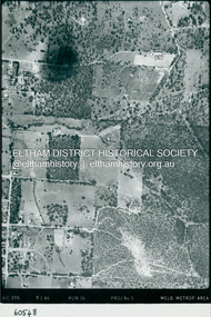 Eltham District Historical Society Inc
Photograph - Aerial Photograph, Landata, Eltham, Luck St; Bible St to Beard St, Dec. 1945
Centred on present day Eltham East Primary School, east of Main Rd along Luck St to Beard St Historic Aerial Imagery Source: Landata.vic.gov.au Aerial Photo Details: Project No :5 Project : MELBOURNE AND METROPOLITAN AREA PROJECT Run : 36 Frame : 60548 Date : 12/1945 Film Type : B/W Camera : EAG4 Flying Height : 10200 Scale : 6000 Film Number : 195 GDA2020 : 37°42'46"S, 145°09'18"E MGA2020 : 337371, 5824456 (55) Melways : 22 A4 (ed. 42)aerial photo, eltham, arthur street, beard street, bible street, eltham east primary school, frank street, henry street, luck street, stanley avenue, wycliffe crescent, neil webster collection -
 Eltham District Historical Society Inc
Photograph - Aerial Photograph, Landata, Eltham, Main Rd; Railway Rd to Zig Zag Rd, Dec. 1945
Centred on present day Edendale Farm from Glen Park rd to Zig Zag Rd Historic Aerial Imagery Source: Landata.vic.gov.au Aerial Photo Details: Project No :5 Project : MELBOURNE AND METROPOLITAN AREA PROJECT Run : 37 Frame : 60549 Date : 12/1945 Film Type : B/W Camera : EAG4 Flying Height : 10200 Scale : 6000 Film Number : 196 GDA2020 : 37°42'12"S, 145°09'09"E MGA2020 : 337141, 5825486 (55) Melways : 21 K2 (ed. 42)aerial photo, eltham, edendale farm, eltham - yarra glen road, eltham-hurstbridge railway line, gastons homestead, gastons road, glen park road, main road, park road, railway road, wattletree road, zig zag road, neil webster collection -
 Warrnambool and District Historical Society Inc.
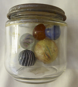
Mixed media - Toy, Marbles, Late 19th century
There is evidence of the game of marbles in the ruins of Pompeii and the tombs of Egyptians as well as early American Indians. The earliest marbles were simply rounded stones which had been polished but this was refined to handmade versions made of clay, stone and glass. It was in the late 19th century that mass production began and it gives testament to the popularity of the game that the Dyke factory of Ohio could produce 1,000,000 marbles a day. It was around 1915 that the mass production of glass marbles began. The game reached the height of popularity in the 1920-1930’s. Many were prized for their designs.The game of marbles was one of the most common games played universally, from childhood hence has a strong link with people of all ages and cultures. Five marbles in glass jar. All are various sizes ranging from large yellow streaked with red and blue, black striped with white, marbled tan, clear with multi coloured streaks and bright blue. Shapes are roughly spherical. Materials range from glass to glazed and stone. Three have pontil marks either on end.The lid of the jar has Nestle vacuumed sealed for extra protection. Use special key to open. Old sticker on base with 173 written in black lead pencil. toys, marbles, children's games, warrnambool, handmade marbles, glass marbles, clay marbles, agate marbles -
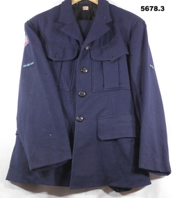 Bendigo Military Museum
Uniform - SERVICE DRESS, WINTER, RAAF, c1942
John William HARKIN. No. 170317, Enlisted 27.06.44, Age 18. Discharged 6.12.48. Rank of LAC in 381 (B)SQD.1. Dress coat - navy blue colour wool fabric, black colour, cotton lining with beige colour cotton lining to sleeves. Buttons - black colour bakelite with metal shank, emblazoned with the King's Crown and a Wedgetailed eagle in flight WW2. On sleeves - Australia shoulder patch with wings and a propeller patch. Right sleeve - gold, blue and red colour "British Commonwealth Forces" patch. Makers label back below collar. 2, Trousers - navy blue colour wool fabric, owners label inside back, 5 button fly. 3. Trousers - navy blue colour wool fabric, makers size label inside back, 4 button fly.1. Maker's label - red embroidery on cotton fabric "M TX/ Size 18". Handwritten black ink "HARKIN'. 2. Owner's label - black ink on cotton "HARKIN/JW/ R.A.A.F." 3. Maker's label - blue ink print on cotton "N384/1942/ SIZE 24". Maker's label on back of trousers - dark blue print on paper - "AIRMEN'S/ TROUSERS'/ 18oz/ Size 24/ Waist 37../ Height 5'9"to 5'10". Black ink stamp "I/ E.C."uniforms, raaf, ww2 -
 Wangaratta Historical Society
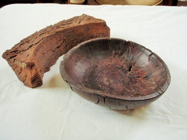
Wooden Fruit Bowl, Red Gum Bowl
This wood is made from Red River Gum tree wood, these trees live for between 500 to 1,000 years of age. The wood in this bowl has been carbon dated in the USA to be 4,500 years old.This bowl is significant because of the age of the wood it is made from. 000016 Wooden Fruit Bowl The timber this fruit bowl was made from was a red gum tree taken from the Ovens river at Tarrawingee (12 km from Wangaratta)where it had been submerged for years. It was made on a lathe by Ken Hill. The bowl warped and cracked shortly after being turned. A piece of the wood was taken to the USA by a visitor where it was carbon dated to be 4500 years old Measurements: Diameter: 22cm Height: 6cm Colour: Dark red brown Photographed beside a piece of natural red gum Tarrawingee is 12 Km North East of Wangaratta on the Great Alpine Road Significance: 4500 year old red gum wood is rare in this area. red river gum wooden bowl wangaratta historical society -
 Bendigo Military Museum
Map - Australian Topographical Survey NAGAMBIE SW Sheet, 1 inch:1 Mile, NW portion Plane Table Field sheet 1921, Australian Survey Corps, 1921
This is a coloured reproduction print of an original Plane Table compilation map sheet of Nagambie area 1inch to 1 Mile scale compiled by Sgt Jack Cullen Australian Survey Corps 30 September 1921. Jack was one of the foundation members of the Australian Survey Corps. Of particular interest is the fact that this is a heighted compilation with contouring (required for Military use) as many early maps were purely planimetric. A table on the right hand side details the number of days that it took to produce the compilation. The reverse side of this print is a copy of the Tallarook plane table South East field sheet.Reprinted coloured Image of Australian Topographical Survey NAGAMBIE SW Sheet,1 inch:1 Mile, NW portion hand drawn Plane Table Field sheet. Includes an itemized summary of work, signed by Sgt J Cullen Australian Survey Corps September1921.royal australian survey corps, rasvy, fortuna, army survey regiment, army svy regt, asr -
 Kiewa Valley Historical Society
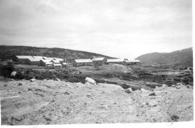
11 Black and White photographs of the Rocky Valley area, c1948
In October 1947 construction was commenced on the erection of the workmen's camp at Rocky Valley. Also in 1947 construction of a stream diversion was commenced to allow excavation to commence for the dam wall. In the summer of 1948/49, stripping of the foundation area on both sides of the river was carried out. Weather conditions were not always favourable during the construction, particularly 1955/56 summer, and work would have to cease each year for the winter season due to the severe conditions. The dam is a earth and rock fill structure with a height of about 30.5 metres and crest length 518.16 metres and was completed in March, 1959.These photographs show the type of terrain in the area prior to the construction and filling of Rocky Valley Dam. Also of interest is the type of accommodation provided for those working on the construction and the early cranes available in the 1940/50's. Of historical importance to understand the conditions in the early construction of the Kiewa Hydro Electric SchemeEleven small black and white photographsPhoto No. 1 - on the back, printed in ink"Rocky Valley - New Mess & offices Dec. 1948". In pencil '14 on the back Photo No. 2 - on the back, printed in ink "Rocky Valley Camp. October 1948". Also stamped on the back "998L" Photo No. 3 -on the back, printed in ink "Rocky Valley Hostel October 1948". Also stamped on the back '998L' Photo No. 4 - on the back, printed in ink "Spion Kopje from bedroom window. October 1948". Stamped on the back '998L'. Photo No. 5 - on the back, printed in ink "Rocky Valley Basin Dec. 1948." In pencil on back, 14. Photo No. 6 - on the back, printed in ink "Site of Wall for Rocky Valley Dam Dec. 1948". In pencil on back, 14. Photo No. 7 - On the back, printed in ink "Commencing of Diversion Tunnel Rocky Valley December 1948". In pencil on back, 14. Photo No. 8 - on the back, printed in ink "One of the two electric cranes at Rocky Valley December 1948". In pencil on back, 14. Photo No. 9 - on the back, printed in ink "'Rapier' (H.Y.) electric crane Rocky Valley December 1948". In pencil on back, 14 . Photo No. 10 - on the back, printed in ink " Pretty Valley Pump line construction Mt. Cope in Background Nov 1948. Circular stamp with the words 'print by Wilson White Albury' in the circle. Photo No. 11 - on the back, printed in ink "Stringing cable on Ruined Castle October 1948. Same stamp as No. 10. In pencil '31'. rocky valley; pretty valley; ruined castle; bogong high plains; kiewa hydro electric scheme -
 Warrnambool and District Historical Society Inc.
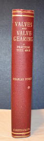
Book, Charles Hurst, Valves and Valve-Gearing, 1907
This is a technical book regarding valves and their maintenance in machinery.This is a book of 258 pages plus 86 pages of advertisements. The cover is dark red with an embossed shield on the front cover and gold printing on the spine. The pages contain a black and white photograph, many illustrations and diagrams and several pages of fold-out sketches. non-fictionThis is a technical book regarding valves and their maintenance in machinery. henry family, warrnambool woollen mill, valves and valve gearing -
 Eltham District Historical Society Inc
Photograph - Aerial Photograph, Landata, Research, Vic, Apr. 1963
Centred on present day Marconi Court, Research bounded by Maroondah Aqueduct to north, Thompson Crescent to south, Joselyn Drive to east and Eltham Research Oval to west. Historic Aerial Imagery Source: Landata.vic.gov.au Aerial Photo Details: Project No :486 Project : MELBOURNE (1963) PROJECT Run : 5 Frame : 62 Date : 04/1963 Film Type : B/W Camera : RC8 Flying Height : 5100 Scale : 9600 Film Number : 1805 GDA2020 : 37°42'24"S, 145°10'43"E MGA2020 : 339434, 5825157 (55) Melways : 22 F3 (ed. 42)aerial photo, neil webster collection, 1963-04, joselyn drive, marconi court, melway 22f3, research (vic.), research oval, thompson crescent -
 Eltham District Historical Society Inc
Photograph - Aerial Photograph, Landata, Research, Vic, Apr. 1972
Centred on present day Maroong Drive, Research bounded by Allendale Road to north, Thompson Crescent to south, Eltham College to east and Parsons Road to west. Historic Aerial Imagery Source: Landata.vic.gov.au Aerial Photo Details: Project No :985 Project : MELBOURNE 1972 Run : 26 Frame : 193 Date : 04/1972 Film Type : B/W Camera : RC10 Flying Height : 5700 Scale : 9600 Film Number : 2636 GDA2020 : 37°42'04"S, 145°10'33"E MGA2020 : 339187, 5825794 (55) Melways : 22 F1 (ed. 42)aerial photo, neil webster collection, 1972-04, allendale road, eltham, eltham barrel, eltham college, maroong drive, melway 22f1, parsons road, research (vic.), thompson crescent -
 Eltham District Historical Society Inc
Photograph - Aerial Photograph, Landata, Eltham, Vic, Apr. 1972
Centred on present day Ryans Road at Sandra Avenue, Eltham bounded by Progress Road to north, Brougham Street to south, Bible Street to east and Outlook Crescent to west. Historic Aerial Imagery Source: Landata.vic.gov.au Aerial Photo Details: Project No :985 Project : MELBOURNE 1972 Run : 27 Frame : 48 Date : 04/1972 Film Type : B/W Camera : RC10 Flying Height : 5700 Scale : 9600 Film Number : 2636 GDA2020 : 37°42'41"S, 145°08'38"E MGA2020 : 336392, 5824574 (55) Melways : 21 H4 (ed. 42)aerial photo, neil webster collection, 1972-04, eltham, bible street, brougham steet, melway 21h4, outlook crescent, progress road, ryans road, sandra avenue, montmorency -
 Eltham District Historical Society Inc
Photograph - Aerial Photograph, Landata, Montmorency, Vic, Apr. 1972
Centred on present day Olympic Avenue at Grand Boulevard, Montmorency bounded by Meruka Drive to north, Main Road to south, Main Road to east and Alban Street to west. Historic Aerial Imagery Source: Landata.vic.gov.au Aerial Photo Details: Project No :985 Project : MELBOURNE 1972 Run : 28 Frame : 206 Date : 04/1972 Film Type : B/W Camera : RC10 Flying Height : 5700 Scale : 9600 Film Number : 2635 GDA2020 : 37°43'21"S, 145°07'46"E MGA2020 : 335154, 5823329 (55) Melways : 21 E7 (ed. 42)aerial photo, neil webster collection, 1972-04, eltham, alban street, grand boulevard, lower plenty, main road, melway 21e7, meruka drive, montmorency, olympic avenue -
 Eltham District Historical Society Inc
Photograph - Aerial Photograph, Landata, Eltham, Vic, Apr. 1972
Centred on present day Mays Road at Stringybark Road, Eltham bounded by Nyora Road to north, Yarra River to south, Reynolds Road to east and Bible Street to west. Historic Aerial Imagery Source: Landata.vic.gov.au Aerial Photo Details: Project No :985 Project : MELBOURNE 1972 Run : 28 Frame : 209 Date : 04/1972 Film Type : B/W Camera : RC10 Flying Height : 5700 Scale : 9600 Film Number : 2635 GDA2020 : 37°43'33"S, 145°09'28"E MGA2020 : 337647, 5823013 (55) Melways : 22 B8 (ed. 42)aerial photo, neil webster collection, 1972-04, eltham, bible street, mays road, melway 22b8, nyora road, reynolds road, stringybark road, yarra river -
 Eltham District Historical Society Inc
Photograph - Aerial Photograph, Landata, Eltham, Main Road; Henry St to Bellevue Rd, Dec. 1945
Eltham, Main Road; Henry St to Bellevue Rd, and east along Luck St to present day Eltham East School Historic Aerial Imagery Source: Landata.vic.gov.au Aerial Photo Details: Project No :5 Project : MELBOURNE AND METROPOLITAN AREA PROJECT Run : 36 Frame : 60549 Date : 12/1945 Film Type : B/W Camera : EAG4 Flying Height : 10200 Scale : 6000 Film Number : 228 GDA2020 : 37°42'45"S, 145°08'59"E MGA2020 : 336903, 5824465 (55) Melways : 21 K4 (ed. 42)aerial photo, arthur street, bellevue road, bible street, diamond street, dudley street, elsa court, eltham, eltham east primary school, gahan house, henry street, livingstone road, luck street, main road, pryor street, neil webster collection -
 Australian Gliding Museum
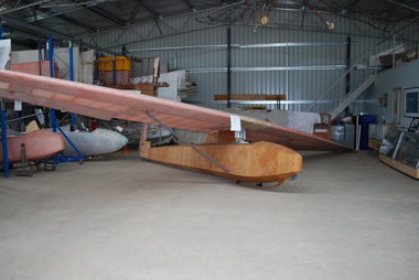
Machine - Glider – Sailplane, 1930s
This Dunstable Kestrel glider, which came to be known as the "Red Kestrel" on account of its colour scheme, was built from plans by Percy Pratt between 1936 and 1938. It was first flown in 1938. Thereafter, it was flown regularly by Pratt at Geelong, Victoria. At the national rally organized by the Australian Gliding Association in December 1939 – January 1940 at the Belmont Common, Geelong, Victoria, Pratt, in his Kestrel, recorded an exceptional 13 kilometre cross country flight of one hour 43 minutes reaching a height of approximately 5500 metres [Allan Ash, Gliding in Australia, p 86]. This Dunstable Kestrel glider represents a good example of a 1930s era sailplane. It is one of three of the type that currently exist in Australia. The aircraft is also important for Australian gliding history because it was built, owned and flown by gliding pioneer Percy Pratt.Wooden airframe covered with plywood and fabric. In course of restoration.australian gliding, glider, sailplane, dunstable, kestrel, bill manuel, percy pratt, belmont, geelong -
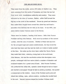 Robin Boyd Foundation
Document - Manuscript, Robin Boyd, The Melbourne Book, 1966
Description of first grid drawn of Melbourne by Robert Hoddle and design impetus; naming of gridiron streets; Charles Troedel prints/The Melbourne Album, F. Cogne drew Melbourne scenes on lithographic stones; Harold Freedman drew same scenes of Melbourne 1964/65; comparative discussion of Melbourne then and now; between 1865-1965 substantial buildings erected and demolished; cable tram; strength and delicacy of Melbourne style; first tree planting; first electric tram 1927; lifting of building height limits 1956; list of representative buildings; Melbourne unlike other capitals as it was not conceived as a capital city.Published as a chapter titled 'The Town at Port Phillip' in 'The Book of Melbourne and Canberra', The Griffin Press, Adelaide 1966Typewritten (c copy), quarto, 14 pagesjohn batman, john fawkner, robert russell, robert hoddle, charles troedel prints/the melbourne album, f. cogne; cable trams; building height limits; tree planting; electric tram 1927; representative buildings, robin boyd, manuscript -
 Bendigo Historical Society Inc.
Photograph - Postcards of Bendigo, Valentine and Sons Publishing Co, c1910
Valentine & Sons of Dundee were Scotland’s most successful commercial photographers. In the early 1900s, at the height of the postcard craze, they published large numbers of postcards in the U.K., Canada, U.S., Australia and South Africa. Even though enthusiasm for postcards eventually waned, Valentine & Sons continued to produce cards into the 1960s and 1970s. Numerical ranges belonged to Valentine & Sons’ branches in other countries, as follows: USA – 200,000s; Australia – 300,000s; and South Africa – 500,000s. New Zealand cards were produced but these seem generally to have been numbered in the U.K. series, which bore numbers less than 100,000. Thirty-eight photos of postcards of Bendigo, city centre, published by Valentine and Sons Publishing Co.history, bendigo, ted hocking collection, valentine postcards -
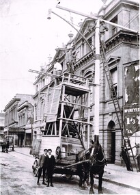 Ballarat Tramway Museum
Photograph - Positioning street lights - Lydiard St North, Ballarat late 1890s, 2022 - Digital print
Photo of the installation of an electric arc type street lamp in Lydiard St North, near the Provincial Hotel Ballarat. The tower wagon is drawn by a single horse. Two boys standing alongside while two men are on the top of the wagon, a man on the top of the ladder is positioning a lifting beam while two men on the ground hold the rope for this beam. On the side of the wagon is possibly an extension that could be lifted onto the top of the tower itself to give a greater working height. The buildings between Mair St and the railway station on the west side of Lydiard St North remain in position. Yields information about the methodology of the late 1890's to install street lighting in BallaratDigital print of a Positioning street lights Lydiard St North Ballarat late 1890sarc lamps, ballarat, lydiard st north, electric lighting, tower wagons, horses, workmen, street lights -
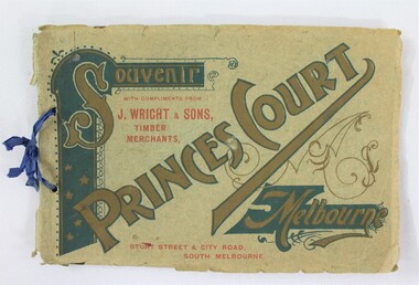 Wodonga & District Historical Society Inc
Booklet - Souvenir Booklet for Princes Court Amusement Park, Melbourne c. 1904-1905
Princes Court was an amusement park in Melbourne, located on St Kilda Road. Established in 1904, it closed its doors in 1909 after poor ticket sales due to Melbourne's temperamental weather. The park featured a toboggan ride and water chute ride where patrons inside open carriages were plunged down sloping structures from a height at great speeds. The park's other facilities and activities included a rifle range, a tug of war game, a Japanese tea house, a wine bar, a variety show, an open air cinema, and roller skating and bicycle races.This item contributes to our understanding of social life and recreation in early twentieth century Victoria. A souvenir booklet for Princes Court, an amusement park in Melbourne, printed for the years 1904-5. The booklet features photographs of the park's attractions, and advertisements for local businesses in Melbourne. wodonga, melbourne, princes park, amusement park, rides, fair, fairground, japanese tea house, st kilda -
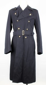 Warrnambool RSL Sub Branch
RAAF Gaberdine Overcoat, Australian Government Clothing Factory (A.G.C.F.), 1976
This coat was issued to Airman Bernard Farley in 1976 as an initial issue of uniform. Bernard was enlisted in the Royal Australian Air Force in Warrnambool on 26th January 1976. This item is a Royal Australian Air Force uniform that was issued for the airman Bernard Farley. It has historic and social significance as an item of local military history. It is also in near perfect condition.RAAF Blue Gaberdine Greatcoat/Overcoat. Double Breasted. Belted at waist. Partly lined inside body; sleeves fully lined. Two vertical pocket openings at belt height give access to large inner pocket and to separate inner clothing. Double line of 5 Gold coloured plastic(?) buttons with Crown and Wingson on left and right front of coat. Single black plastic button on inside of coat immediately behind top left gold button. Epaulettes on shoulders are attached at outer end and have a small gold coloured button and button hole attachment at inner end; 'RAAF' sewn in lighter blue thread on outer end of each epaulette. Sleeves have 3 small gold buttons on cuffs.Attachment inside collar reads; A.G.C.F. (Australian Government Clothing Factory) Vic 1976. Broad Arrow Symbol. 8405.66.013.6603. Size 3L. No. NAME. Attachment inside lower left reads; handwritten, 17481, E746813, 3L,30560. 27.Blue Stamp - S broad arrow Nraaf, great coat, royal australian air force, r.a.a.f., air force, uniform, coat, bernard farley, farley, airman, warrnambool, warrnambool rsl -
 Federation University Historical Collection
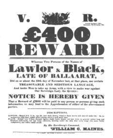
Poster, Reward Poster for the Capture of Peter Lalor and Black (copy), c1987
After the Eureka Stockade the government offered a reward for the leaders of the rebellion. Peter Lalor's name is incorrectly spelt 'Lawlor' in the poster, which suggests the correct pronunciation of Lalor.A Eureka Stockade reward poster as reproduced in Withers 'History of Ballarat'. The poster is black on white and relates to a 400 pound reward offered for Peter Lalor and Black after the Eureka Stockade. Peter Lalor is described as 5 feet 11 inches in height, age 35, dark hair, whiskers dark brown and shaved under the chin, no moustache, long face, rather good looking, and is a well made man. Black is described as over 6 feet tall, straight figure, slight build, bright red hair worn in a general rather long and brushed backwards, red and large whiskers, meeting under the chine, blue eyes, large thin nose, ruddy complexion, and rather small mouth.ballarat, eureka stockade, peter lalor, lalor, lawlor, black, william haines, haines, ballarat reform league, reward poster -
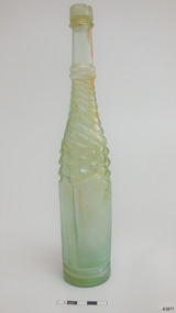 Flagstaff Hill Maritime Museum and Village
Container - Bottle, 1870s-1910s
This clear, green tinged, Half Whirley (or Whirly) salad oil bottle has been handmade by a glassblower from 1870s-1910s. A bottle with such elaborate decoration would have been sought after as there was no need to decant the sauce into another jug or bottle to make it acceptable for table service. It is possible that this bottle was recovered from the Loch Ard, wrecked in 1878. A diver found the bottle on a shipwreck in the coastal waters of Victoria about 100 years from when it was made. The diver who found this bottle has recovered objects from several different shipwrecks between the late 1950s and early 1970s. A sizeable proportion of those objects was from the wreck of the famous clipper ship Loch Ard. This salad oil bottle may very well have been amongst that ship’s cargo. It is part of the John Chance Collection. A paper titled ‘Glass Bottles from the Loch Ard Shipwreck (1878): A Preliminary Study’ by Iain Stuart, (published in Australian Historical Archaeology, 9, 1991) included a study of twelve salad oil bottles from the wreck of the Loch Ard. The bottles were of this same Half Whirley design (half meaning that it was Whirley on the upper half but not on the lower half of the body), as well as the same colour and size. A diagram of one of these twelve bottles matches the bottle in our collection. The paper mentions that eleven of the twelve bottles have a number on their base, just as this one has. It is estimated that foreign and salad oil bottles totalled four percent of all of the bottles carried as cargo on the ship. The Half Whirley bottle has side seams from below the lip to the base, indicating that the bottle was made in a two-piece mould that included the heel, body, shoulder and neck. The fancy ‘whirly’ twist pattern and panelled sides would have been cut into the mould’s inner surface. The uneven thickness of the ridge around the base comes from adding a separately moulded and embossed base after the bottle was removed from the mould. The applied finish (mouth and lip) was also added to the bottle. The elongated bubbles in the glass are evidence of the glass being mouth blown into the mould, thus forming the shape and pattern from the inside shape of the mould. The bottle probably had a glass stopper with a round top and wedge-shaped shank with a ground surface, allowing the bottle to be re-sealed. The ring between upper and lower lip allows the closure to be sealed and anchored. The embossed numbers are either “133” or “833” and may represent a particular bottle pattern, manufacturer or filler. Although the bottle is not currently linked to a particular shipwreck, it is recognised as being historically significant as an example of bottles imported for use in Colonial Victoria in the mid-to-late 19th century. This whirley salad oil bottle is matches the whirley salad oil bottles recovered from the Loch Ard in the 1990s, adding depth of interpretation to the array of salvaged Loch Ard artefacts in Flagstaff Hill’s collection. The salad oil bottle is an example of the type of food condiment containers that were used in Victoria’s early days. The bottle is also significant as it was recovered by John Chance, a diver in Victoria’s coastal waters in the late 1960s to early 1970s. Items that come from several wrecks, including the Loch Ard, have since been donated to the Flagstaff Hill Maritime Village’s museum collection by his family, illustrating this item’s level of historical value. Bottle; glass Half Whirley salad oil bottle, green-tinged, with some opalescence. Handmade, elaborately decorated bottle with round neck and base, and five-sided body. Applied double lip; straight upper, flared lower. The lower neck and shoulder have twisted spiral whirley patterns in the glass. The body tapers slightly inwards towards the base. It has five plain panels, one wider than the others. Side seams run from below the lip to the heel. The heel of the bottle is uneven in width, height and density where it joins the body of the bottle. The base is not level. Embossed characters on base. Glass has elongated bubbles towards the base and orange-brown sediment inside, on one side. Embossed "133" or “833” (the first character may be an “8”) flagstaff hill, warrnambool, flagstaff hill maritime museum, maritime museum, shipwreck coast, flagstaff hill maritime village, great ocean road, shipwreck artefact, john chance, glass bottle, antique bottle, handmade, mouth blown, blown bottle, 19th century bottle, collectable, bottle, green glass, tinged green, two piece mould, food bottle, oil bottle, salad oil bottle, whirley, whirly, half whirley, condiment bottle -
 Ballarat Heritage Services
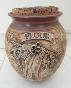
Ceramic - Ceramics, Ceramic Canister by Wartook Pottery, c1990
Graham WOOD Wartook Pottery was set up in the early 70s by Graham Wood, and was sucessful for nearly 25 years. It then moved to Halls Gap (The Grampians, Victoria), and the name was changed to Jimmy's Creek Pottery in 1998. The pottery conitnued under that name until 2003. when cheap imports hurt the business. Hand thrown ceramic canister with 'Gum Leaf' design. According to decorator Wendy McGuiness all decoration was made and applied by hand - an extremely time consuming activity. Texture to the body of each piece was created by using a piece of coral. Tenmoku glaze was applied to the top of the pieces, with iron oxide to the main body. This was the first of the Wartook range that sold commercially from around 1987 all over Australia. At the height of production Wartook Pottery had 5 employees, including a new wheel potter (who was adept at creating the pieces as Graham had done before). Additional ranges were still hand thrown, but with a floral wreath (slip cast) applied to the top of each pot, as well as a range that used decals for decoration. australian landscape pottery, les macleman, ceramics, landscape, graham wood -
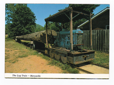 Marysville & District Historical Society
Postcard (item) - Colour postcard, Colorscans (Publishing) Pty Ltd, The Log Train - Marysville, Pre 2009
A colour photograph of a log train that was used in a sawmill in Marysville in Victoria.A colour photograph of a log train that was used in a sawmill in Marysville in Victoria. The Log Train was originally in use at Anderson's Mill - Marysville. The original log came from a Messmate Stringy bark (Eucalyptus Obliqua), age 134 years; height 53.3 metres; felled in 1970 at Elliots Creek, Mt. Margaret. The volume of the log was 6,000 super feet. The original log was destroyed in the 2009 Black Saturday bushfires. This postcard was produced by Colorscans Publishing as a souvenir of Marysville.Colorscans c PUBLISHED & PRINTED BY COLORSCANS (PUBLISHING) PTY. LTD. 118-120 BRIGHTON STREET, RICHMOND. 3121 Supa-vu/ cards MARYSVILLE - VICTORIA The Log Train was originally in/ use at Anderson's Mill - Marysville./ The log came from a Messmate/ Stringy bark (Eucalyptus Obliqua),/ age 134 years; height 53.3 metres;/ felled in 1970 at Elliots Creek, / Mt. Margaret. Volume of the log/ 6,000 super feet. Photographed and Distributed by:/ K & H. ELLIS - 35 Old Warburton Road,/ Warburton 3799marysville, log train, anderson's mill, messmate stringy bark, eucalyptus obliqua, victoria, colorscans publishing, postcard, souvenir