Showing 839 items
matching lake park
-
 Eltham District Historical Society Inc
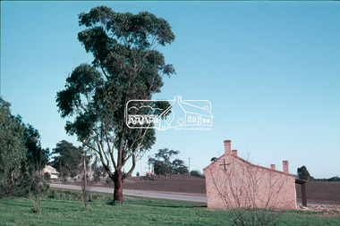
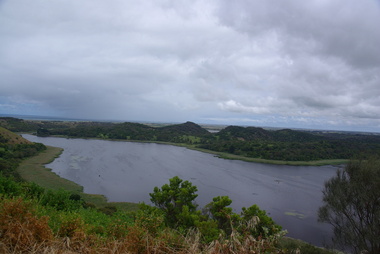
Slide, Construction of Eltham Town Park, 25 Jul 1973
Construction of Eltham Town Park; landscape has been scupltured and lakes formed. View looking from near Shillinglaw Cottage south to Bridge Street. The park was later renamed Alistair Knox Park.35 mm colour positive transparency Mount - Agfacolor Service (Blue)Memorial Park 25 July 1973eltham, main road, alistair knox park, eltham town park, shillinglaw cottage, bridge street -
 Eltham District Historical Society Inc
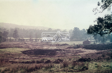
Slide, Construction of Eltham Town Park, 25 Jul 1973
Construction of Eltham Town Park; landscape has been scupltured and lakes formed. Shillinglaw Cottage and the Eltham Trestle Bridge visible. The park was later renamed Alistair Knox Park.35 mm colour positive transparency Mount - Agfacolor Service (Blue)Memorial Park 25 July 1973eltham, alistair knox park, eltham town park, shillinglaw cottage, 1973-07-25, eltham trestle bridge -
 Eltham District Historical Society Inc
Slide, Construction of Eltham Town Park, 25 Jul 1973
Construction of Eltham Town Park; reclamation of the eastern end of the tip overflow and landscape in progress of being sculptured and lakes formed. Shillinglaw Cottage and the Eltham Trestle Bridge visible. The park was later renamed Alistair Knox Park.35 mm colour positive transparency Mount - Agfacolor Service (Blue)Memorial Park 25 July 1973eltham, alistair knox park, eltham town park, shillinglaw cottage, eltham trestle bridge, eltham tip, trestle bridge -
 Eltham District Historical Society Inc
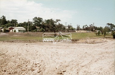
Slide, Construction of Eltham Town Park, 22 Feb 1974
Construction of Eltham Town Park, later renamed Alistair Knox Park. View looking towards the intersection of Main Road and Bridge Street. The lake body has been formed and young trees planted.35 mm colour positive transparency Mount - Agfacolor Service (Blue)alistair knox park, eltham town park, bridge street, main road -
 Eltham District Historical Society Inc
Slide - Photograph, Eltham Town Park, c.May 1988
In 1981 the Shire of Eltham Historical Society was asked by the Victorian Place Names Committee to comment on a proposal by the Shire of Eltham to assign names to parklands in Eltham as follows:- "Eltham Common" - the area between the municipal offices, Main Road, the Eltham railway -line, and Panther Place and containing Shillinglaw Cottage. The Shire has advised that this name has been used locally for the site since about 1975. "Alistair Knox Park" - the area bounded by the Eltham railway -line, Panther Place, Main Road, Bridge Street, and Susan Street, and through which flows the Diamond Creek. The area has been known locally as "Eltham Town Park" The proposed name "Alistair Knox Park" had created some local controversy with a number of reversals of the Council's decision and letters to the local paper both for and against the proposal. The society was reluctant to be drawn into this controversy particularly as there were known to be members with strong views both for and against the proposed name. The society appreciated the work done by Alistair Knox both in the formulation of the park concept and in its development but because of the controversy generated by the proposed naming and also because of the wide general use of the park by the public·, the name Eltham Town Park was felt more appropriate. The society noted that there was no outstanding historical associations with the land comprising the park which would warrant naming the park after any particular person, place or event. No objection was raised to the Eltham Common proposal as set-out above. The decision was made in the knowledge that Alistair Knox had been associated with the society over many years and was a prominent figure in the recent history of Eltham. He was regarded as a key figure in the environmental building movement and in particular was renowned for his use of mud bricks as a building material. He served as a councillor of the Shire of Eltham from 1971-1975, his final year as Shire President. It was during these years that the proposals to create the park in its present form were shaped and Alistair played a leading part in the decision to make it a landscaped passive recreational park rather than a sporting area. The parklands comprise a section of the Diamond Creek valley. The creek itself flows through the centre of the area which is overlooked by steep hills on each side. The parks form part of the land purchased from the Crown in 1851 by J.M. Holloway and then subdivided into allotments and called "Little Eltham". While most of the area was subdivided into residential lots the creek valley was subdivided into lots suitable for small farms. Some further subdivision took place over the years and the whole of the parks now comprises eight separate titles. A list of some of the former owners has been compiled but exhaustive research on all owners has not been carried out. The ownership of one parcel has been traced back to when it was purchased from Holloway by John Hicks Petty in 1874, long after it was subdivided. Other families owning land within the area over the years included Lyon, Rees, Clark, Waterfall, Carrucan, Graham, Hill and Morant. The character of the valley area has remained rural while development occurred on each side. Early photos show the area as orchard and grazing land. In 1901 the railway was constructed through the area resulting in the timber trestle bridge across the Diamond Creek. which is an important feature of the park landscape. A memorial obelisk to the Eltham servicemen killed in World War 1 was erected at the south eastern corner of the park. The site is now within the intersection of Main Road and Bridge Street and the memorial was shifted in the 1950s to the Eltham R.S.L. clubrooms. Following the financial failure of the local sub-branch, the memorial obelisk was again relocated to the Eltham War Memorial building precinct in 2011. During the early 1960's the Council started purchasing the land which now comprises the parks. In the late 1960's the area to the east of the Diamond Creek was used as a garbage tip and filled above the flood plain of the creek. When this area was filled the tip was transferred to the west side of the creek. From the early 1970's the area has been progressively developed as a park for passive recreation with ornamental lakes, extensive tree planting and landscaping. The character of the valley before the days of the tip has been recreated and this has earned a Landscape classification from the National Trust, an unusual honour for a man-made landscape. The parks are not only attractive in appearance. The large number of people using them, particularly at weekends and holidays is evidence of their popularity and the foresight and careful planning of local residents, Councillors and Council Staff. 35mm colour positive transparency (1 of 23) Mount - Kodak EktachromeProcess Date MAY 88Meltham, main road, alistair knox park, eltham town park -
 Victorian Interpretive Projects Inc.
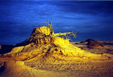
Photograph - colour, Clare Gervasoni, Mungo at Dusk, 07/09/2008
Mungo National Park is a desert north of Mildura. It has numerous archaeological relics, and is the site of ancient Aboriginal burials known as Mungo Man and Mungo Woman. This photograph was taken during an expedition by Naga Tours in 2008.Colour photograph in digital format showing sand dunes and dramatic natural lighting at dusk at Mungo National Park. lake mungo, desert, archaeology, sand dune -
 Victorian Interpretive Projects Inc.
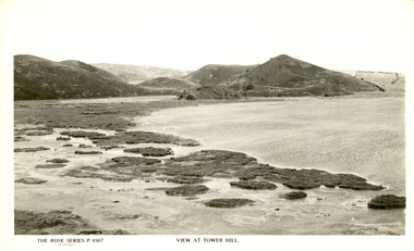
Photograph - Colour, Clare Gervasoni, Tower Hill, Victoria, 2013
The Tower Hill Reserve is located inside a dormant volcano, and features a lake and wetlands. It became Victoria's first national park in 1892, but by the 1930s the early settlers had cleared much of the land for grazing, cropping and quarrying. In the 1960s the bare hills and islands were revegetated based in species identified from Eugene von Guerard's painting of Tower Hill. Tower Hill was formed around 30,000 years ago in a violent volcanic eruption. The initial eruption created the outer rim of the volcano, and later smaller eruptions formed the internal hills that are evident today. The layers of volcanic ash layers include artefacts relating to indigenous communites.A series of colour digital photographs showing Tower Hill, near Port Fairy, Victoria. Tower Hill is an extinct volcano.tower hill, volcano, extinct -
 Coal Creek Community Park & Museum
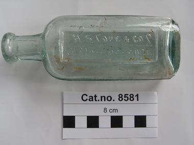
Bottle, glass, 1914-1916
TROVE : Maryborough and Dunolly Advertiser (Vic. : 1914 - 1918) Monday 5 January 1914 p 4 Advertising 'QUALITY EXCELS. H. S. COPE & CO., STATION BRAND. REFINED EUCALYPTUS OIL ONCE TRIED ALWAYS USED. H. S. COPE & CO, MARYBOROUGH.' TROVE : Ararat Chronicle and Willaura and Lake Bolac Districts Recorder (Vic. : 1914 - 1918) Tuesday 5 September 1916 p 2 Article 'H. S. Cope and Co., of Mori Mori, was badly injured by being kicked on the thigh by a young pony whilst he was endeavoring to catch his own for the purpose of driving to his home. He was unable to walk without assistance as a result of the kick, and it will be some time before he completely recovers from the effects.'Clear green tinted glass bottle , oval in section with text on side and monogram on base embossed onto the glass.'H S COPE & CO MARYBOROUGH' on side. A G M on base. -
 Melbourne Legacy
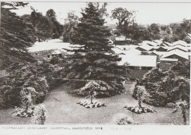
Photograph, Harefield UK, 1919
... on the front 'The Lake, Australian Hospital Harefield Park, Mdx... Park 1917'. Handwritten label 'The lake in front of the mansion ...Copies of photos of the No 1 Australian Auxiliary Hospital set up in the ground of Harefield Park during the first World War. They were wooden huts. Also the graves of the deceased soldiers in the Australian Military Cemetery in 1919 in Harefield's St Mary's churchyard. Plus two photos of the Mansion at Harefield one in 1917 and one from 1927. Harefield Park was owned by Australian couple, Letitia Billyard-Leake (born Letitia Leake) and her husband Charles Billyard and their 4 children. The family donated their property, Harefield Park, to the Australian Government for use as an Australian-run hospital. The family moved off the property and lived nearby to help run the hospital. Letitia and her daughter, also named Letitia, ran the canteen while Charles Billyard organised activities and was a hospital board member. (from research from Carol Grbich and John Berger). During World War 1 the Australian Auxiliary Hospital No.1 was stationed at Harefield Park in Harefield, UxBridge, Middlesex UK. 111 Australian soldiers and one nurse from the hospital are buried at St Mary's Church, Harefield. This became an Australian Military Cemetery with individual headstones and an obelisk and arch. The headstones which are of a scroll design unique amongst Commonwealth War Graves Commission cemeteries were chosen by the staff and patients at the hospital. The arch was erected by the CWGC. Anzac Day services are held there and the local school became involved with the headmaster, Mr Jefferies, bringing the school children to lay flowers on every grave and attend the service on Anzac Day. This started in 1921 and has continued until at least 2021. One school child who attended was Mr Alf Young, he made contact with Legacy in the 1990s and sent photos of the Anzac Day Services and the cemetery. Legacy responded by sending Australian flags for the school children and also Legatee John Cohen met with Mr Young when in London. Melbourne Legacy staff member Susie Howard also visited Mr Young and the cemetery in 1995. Mr Young provided historical photos and information of the area to Legacy. He was featured in the widows' newsletter The Answer many times and his death was announced in The Answer in April 1997, he was 85. Many of the photos he provided were labelled as coming from Mr R G Neil, Photographic historian from Harefield. He holds copyright over those photos.A record that Legacy helped support remembrance of Anzac Day and World War 1 soldiers buried in the UK.Black and white photos x 4 of the Harefield Hospital and area from 1917 to 1927.02067.1 Printed on front 'Australian Auxiliary Hospital, Harefield No 1. 1914-1918'. Handwritten on reverse 'Harefield Park 1917'. Handwritten label 'Hospital as it was 1916-1918'. 02067.2 Handwritten on the reverse 'Part of the old Australian cemetery 1919'. Handwritten label 'The grave on the left "Private Wake" was the first grave in the cemetery'. 02067.3 Printed on the front 'The Lake, Australian Hospital Harefield Park, Mdx.' Handwritten on reverse 'Harefield Park 1917'. Handwritten label 'The lake in front of the mansion 1917'. 02067.4 Printed on the front 'Harefield Park' and 'Coles Watford'. Handwritten on reverse 'The Mansion, 1927 Harefield Park'. All four have a sticker of Mr RG Neil, the photograph historian that provided the reprint.cemetery, harefield, alf young, memorial, wreath laying ceremony, hospitals -
 Hymettus Cottage & Garden
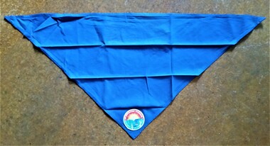
scarf, Scout Scarf
Scouting scarf blue with , belonging to Glen Taffe 3rd Wendouree Scouts 1980s from attending the fourteenth Australian Jamboree at Cataract Park New South Wales 1985-86.scouting movement, glen taffe, jamboree, cataract park, new south wales, 3rd wendouree scouts, ballarat. -
 Hymettus Cottage & Garden
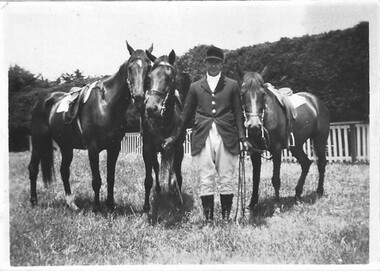
Photograph, W. Burke & Polocrosse ponies Ballarat
Polocrosse was a popular equestrian sport played at Prince of Wales Park Ballarat in the 1950s. This is a small family snapshot of William (Bill) Burke, brother of Mrs Mary Taffe of "Hymettus" Ballarat, with three of his polocrosse ponies taken at his home on Burrumbeet Rd Ballarat.Small snapshot On reverse "Bill Burke" -
 Ballarat Tramway Museum
Slide - 35mm slide/s - set of 6, Noel Simons, 22/05/1971 12:00:00 AM
Set of 6 Kodachrome transparencies taken on 22/5/1971. 1171.1 - Tram 33 at Sebastopol terminus, showing destination of Lydiard St. Nth, with Royal Mail Hotel in the background and three parked cars. Tram has "Twin Lakes" sign on front dash. 1171.2 - as for 1171.1 but taken from other side of tram, has hotel in part of photo. Shows arrangement of tram terminus signs on a pole in the background. 1171.3 - Tram 26 just after arrival at the Lydiard St. terminus, with passengers getting off and driver about to swap ends. Destination has been changed to Sebastopol. Has Lydiard St. shelter in the right edge of the photo. 1171.4 - as for 1171.3 - but with pole turned and looking back along street towards city. Shows the undulating nature of the street. 1171.5 - Tram 26 outbound in Albert St. for Sebastopol, crossing the street near Ophir St. Has a motor cyclist stopped for tram and shows tram stop on the west side of the road. 1171.6 - Tram 26, close up of tram at the Sebastopol terminus with two cars parked along side. Tram has destination of Lydiard St. Nth.1171.1 - "No. 33 at Sebastopol Terminus" and initials "BC" in bottom left hand corner. 1171.2 - "No. 33 at Sebastopol Terminus" and initials "BC" in bottom left hand corner. 1171.3 - "No. 26 at Lydiard St. North terminus" and initials "BC" in bottom left hand corner. 1171.4 - "No. 26 at Lydiard St. North terminus" and initials "BC" in bottom left hand corner. 1171.5 - "No. 26 crossing from left side of Albert St. Sebastopol to right side near Ophir St." and initials "BC" in bottom left hand corner. 1171.6 - No. 26 at Sebastopol Terminus" and initials "BC" in bottom left hand corner. All slides have date stamp of "22 May 1971" in purple ink and Kodak developing date of "Jun 71M7" in red ink. tramways, trams, sebastopol, lydiard st nth, royal mail hotel, tram stops, tram 33, tram 26 -
 Ballarat Tramway Museum
Slide - 35mm slide/s - set of 6, Noel Simons, 27/02/1972 12:00:00 AM
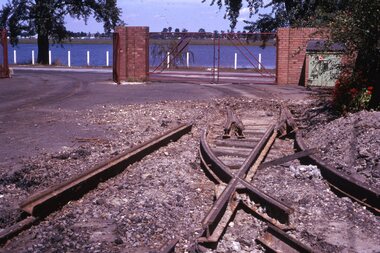
Has a strong association with the early days of the BTPS in preparing to move the tramcars from the depot and working at the former SEC depot itself. Yields information about the work done in the yard to recover materials.Set of 6 transparencies taken on 27/2/1972 on Kodak mounts. 1177.1 - photo of the dismantling of the points leading to "0" road at the SEC depot by the BTPS, looking south to Lake Wendouree. 1177.2 - view across depot front with No. 28 parked slightly outside and No. 40 inside door. Shows trackwork being dismantled and offices at front of depot. 1177.3 - view of No. 40 inside depot. 1177.4 - close up of the point blades leading to "0" road. 1177.5 - view of the front of the depot showing 40 and 28 parked outside, with dismantled point work in the foreground. 1177.6 - view of trackwork at part of Sturt and Drummond Sts. See also Reg Item 3533 for a similar series of photographs.Information written on in blue ink and date stamped on purple ink. 1177.1 - "Depot, Ballarat" 1177.2 - "Depot, Ballarat" 1177.3 - "Depot, Ballarat" 1177.4 - "Depot, Ballarat" 1177.5 - "Depot" 1177.6 - "Sturt and Drummond Sts"tramways, trams, wendouree parade, depot, sturt st, drummond st, pointwork, trackwork, o road, tram 28, tram 40 -
 Ballarat Tramway Museum
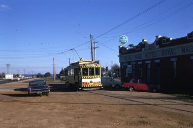
Photograph - Black and White photograph/s - mounted set of 2', John Phillips, late 1960's or early 1970's
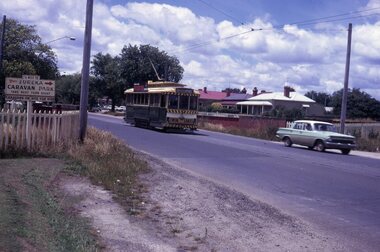
Yields information about the vicinity of the Victoria St terminus and the bridge over the Buninyong Railway line.Black and White photograph mounted on heavy cardboard backing. Photo of Ballarat No. 31, just after leaving Victoria St. terminus, late 1960's or early 1970s crossing over the Eureka siding railway bridge. Taken by John Phillips. Tram has destination of Gardens via Sturt St. West, Twin Lakes advertisement on the front. In the background is Meagher's Hotel with Abbots Lager and Victoria Bitter sign. On the bridge is graffiti "Smash US Imperialism". On the Ballarat side of the bridge is a sign directing travellers to the "Eureka Caravan Park". Has 6 Velcro dots on rear and marks where mounting devices have been removed on the rear. Note image scanned in two runs through a scanner, resulting in the shading in the image file. .1 - Second copy with 4 black Velcro squares and 4 dots on rear - wider view on the right hand side with an additional pole - not scanned.trams, tramways, victoria st, eureka, twin lakes, tram 31 -
 Ballarat Tramway Museum
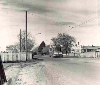
Slide - 35mm slide/s, Peter Moses, Jan. 1966
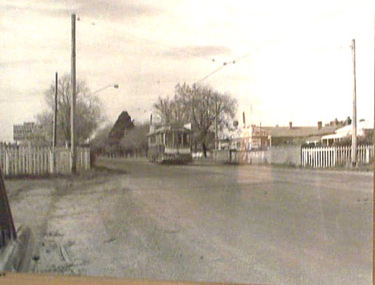
Photo of SEC Ballarat Tram No. 11, west bound after leaving Victoria St. terminus crossing the Buninyong or Eureka Siding railway Bridge. Tram fitted with a "Twin Lakes" and SEC Briquettes roof advertisement and has destination of "Gardens via Sturt St. West". On the left side of the photograph is a roadside advertisement for the "Eureka Caravan Park". Note scanning error in the photograph. Kodak cardboard mount slide, taken by Peter Moses January 1966. Actual slide does not give the year, but slide fitted in with numbering sequence for 1966.On back of slide in blue ink in bottom right hand corner "P. Moses".tramways, trams, victoria st, railway bridge, tram 11 -
 Ballarat Tramway Museum
Slide - 35mm slide/s, c1962
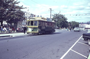
Tram 28 at the intersection of Sturt and Lydiard Streets, with destination Gardens via Sturt St. West, two inspectors by tram, many people sitting on park benches in centre median strip. Tram with lights, but small white strip, has early 'Twin Lakes' sign on front of tram.'F' in blue inktramways, trams, sturt st, tramway centre, lydiard st, tram 28 -
 Ballarat Tramway Museum
Photograph - Black and White photograph - laminated, John Phillips, 1968
Black and white photo of No. 31, inward bound from Victoria St. crossing the Buniyong railway overbridge. Meaghers Hotel in background and ad for Eureka Caravan park. No cars on the road. 'Smash Imperialism' graffiti on bridge beam. Tram fitted with lights, small number over headlight, and long Twin Lakes sign under headlight. Image on data base file, made from digital photo of photo 22/6/02.trams, tramways, ballarat, victoria st., tram 31 -
 Ballarat Tramway Museum
Book, Ballarat Litho & Printing Co, "The Picturesque Folio of Ballarat - 'The Modern Athens", 1904
Forty two page book with red covers, titled "The Picturesque Folio of Ballarat - 'The Modern Athens". Sheets have been individually printed both sides, stapled and then glued to the covers. Cover - gives title and printer details First sheet - with a greetings sheet for Good wishes and seasons greetings. Has a printed date of 1905. See Inscriptions. Dated 22/11/1904. Pages 3 - 10 - a historical sketch of Ballarat, compiled by Lieut-Colonel R. W. Williams V.D. Pages 12 - 41 - photos of Ballarat and district - such as: Sturt St The Lakes Post Office - note the trams clock board - taken at corner of Lydiard and Sturt Streets, looking east. The Gardens Queen Victoria Square Lydiard and Sturt St with a horse tram in the photo Victoria Park Eureka Monument The Statues Botanical Gardens Benevolent Asylum Hospital The City Oval - Richards & Co Photograph Fairy Land - the Lake Railway Station with a D class loco waiting for a signal, 3 post home before the level crossing. Has Irwin's Provincial hotel in view. Gong Gong Lake School of Mines and Methodist Church Lake Fountain A Ballarat view - 1853 - 54. View Point Gong Gong reservoir embankment South Star Mine Lal Lal Falls Band & Loch Mine On last page has the logo for the printers - Ballarat Litho & Printing Co, successors to F. W. Niven & Co. 56 and 58 Lydiard St. Ballarat. PDF scan of book added 21/9/2019 as btm3326i.pdfOn first page in black ink " to Chorus? Dodds, from Robert Dodds, and dated 22 Nov 1904.trams, tramways, ballarat, horse trams, sturt st, gardens, railway station, hospital -
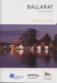 Ballarat Tramway Museum
Book, The Ballarat Visitor Information Centre, "Ballarat Victoria's goldfields Official Visitor Guide", "Ballarat where Parks and Gardens come to life", 2011
.1 - Full colour, 100 page, book, A5 size titled "Ballarat Victoria's goldfields Official Visitor Guide", with an autumn view across Lake Wendouree. Gives details, maps accommodation listing, attractions etc of the Ballarat area. Pages30 and 31 detail the Ballarat Tramway Museum and the BTM advertisement on page 48. Published 2011 by The Ballarat Visitor Information Centre. .2 - Full colour 16 page brochure, titled "Ballarat where Parks and Gardens come to life" with rear fold out cover of map of the Ballarat and Buninyong district. Notes steam boats and trams on page 6.trams, tramways, ballarat, visitors, tourist guides, btm, gardens -
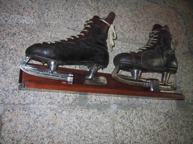 Parks Victoria - Mount Buffalo Chalet
Skates
Ice skates used to skate on Lake Catani. Ice skating was a popular activity for guest and visitors to Mt Buffalo. Ice skates were provided for hire by the the first Lessee of the Chalet, John Newton and also Norwegian born Hilda Samsing, who took over from him in 1919 and did much to pioneer and promote winter sports in the Victorian Alpine region . Ice cover on the Lake has not been sufficient for safe skating for many decades. 'After its initial popularity, skating at Mount Buffalo dwindled in the post-war years. According to Museum Victoria curator, Michelle Stevenson, few collections hold historic ice-skates, so any early examples identified in the Chalet collection will be important for their rarity." (Pg 94. Historica) 'Ice-skating was a popular recreational activity in the later nineteenth and early twentieth centuries...According to Michelle Stevenson, Australian Collections hold little material culture relating to its practice other than images and film. The few pairs of ice skates in the Chalet collection, which are in good condition, are important for their rarity as well as for illustrating the popularity of skating on Lake Catani prior to WW2.' Pair of black leather ice scates, mounted on wall. Skates feature white laces, metal blades and brown leather reinforcing area around laces and ankles.Boots are stffed with 1993 newsprint.On skate blade, "Made in Canada 11 1/3 CCM / Senior A" On boot sole , "Made by J Molony " plus worn name label. -
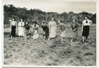 Parks Victoria - Mount Buffalo Chalet
Photograph, "Staff Race at the Guests Sports Meeting"
Photograph of the "Staff Race at the Guests Sports Meeting" at Lake Catani on the 30-12-36. The photo shows 9 women getting ready to run. They are named on the back, Hilda Gawkins, Melva Weston, Mavis Douge, Ella Colelef, Lelia Willis, Jess Sloane, Alice Bell, May Ross."Staff Race at the Guests Sports Meeting" at Lake Catani on the 30-12-36. Hilda Gawkins, Melva Weston, Mavis Douge, Ella Colelef, Lelia Willis, Jess Sloane, Alice Bell, May Ross. -
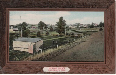 Rutherglen Historical Society
Image, Sporting Corner, Rutherglen Park, 1910 to 1912
Rutherglen Park is located in Murray Street. The grounds shown are now the bowling club. Photo taken from the top of the weir of Lake King.Coloured photograph on a post card, with brown border, showing a view of a one end of the Rutherglen Parksports grounds, rutherglen bowling club, rutherglen park, murray street -
 Whitehorse Historical Society Inc.
Article, On show to the world, 2002
Photographer Margie McKenzie has a range of post cards featuring Blackburn Lake as well as Wattle Park Golf Club and Schwerkolt Cottage.Photographer Margie McKenzie has a range of post cards featuring Blackburn Lake as well as Wattle Park Golf Club and Schwerkolt Cottage.Photographer Margie McKenzie has a range of post cards featuring Blackburn Lake as well as Wattle Park Golf Club and Schwerkolt Cottage.blackburn lake, mckenzie, margie, schwerkolt cottage, postcards -
 Ballarat Heritage Services
Photograph - Photograph - Black and White, Tower Hill, Victoria
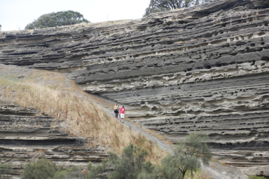
Tower Hill is a volcanic formation believed to have erupted about 32,000 years ago. Its formation is known as a "nested maar" and it is the largest example of its type in Victoria. During formation, molten lava pushed its way up through the Earth’s crust and encountered a layer of water-bearing rock. Violent explosions followed creating a shallow crater which later filled with water to form the lake. Further eruptions occurred in the centre of this crater, creating the islands and cone shaped hills. In 1892 Tower Hill became Victoria’s first National Park. In 1961, Tower Hill became a State Game Reserve under the then Fisheries and Wildlife Department and a major re-vegetation program began. (https://www.towerhill.org.au/index.php/about-reserve/history, accessed 23 December 2019)Black and white photograph of Tower Hill devoid of trees.tower hill, crossley, volcano -
 Ballarat Heritage Services
Photograph - Colour, Tower Hill, 2016, 31/12/2016
Tower Hill is a volcanic formation believed to have erupted about 32,000 years ago. Its formation is known as a "nested maar" and it is the largest example of its type in Victoria. During formation, molten lava pushed its way up through the Earth’s crust and encountered a layer of water-bearing rock. Violent explosions followed creating a shallow crater which later filled with water to form the lake. Further eruptions occurred in the centre of this crater, creating the islands and cone shaped hills. In 1892 Tower Hill became Victoria’s first National Park. In 1961, Tower Hill became a State Game Reserve under the then Fisheries and Wildlife Department and a major re-vegetation program began. (https://www.towerhill.org.au/index.php/about-reserve/history, accessed 23 December 2019)A number of photographs taken at Tower Hill, including the lakes, volcanic ash layer, and koala.tower hill, ash layer, volcano -
 Ballarat Heritage Services
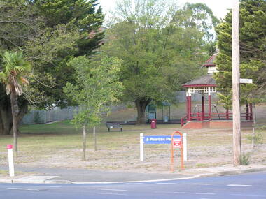
Photograph - Digital photograph, Dorothy Wickham, Pearce's Park, Mount Pleasant
Pearce's Park is at the corner of Barkly and Gladstone Streets, Mount Pleasant, a suburb of Ballarat. It has a children's playground and historical bandstand. See https://www.youtube.com/watch?v=CVN2MStaHgE Isaiah Pearce was an owner of a goldmine and mayor. He built Clowance house in Barkly Street and chose not to build around Lake Wendouree as he thought it was snobbish. Since Pearce's death, the home has been a maternity hospital and a women’s boarding house. It includes a marble-effect entrance, fireplaces, ceilings and cornices. Colour image of Pearce's Park.pearce's park, bandstands, isaiah pearce, mount pleasant -
 Whitehorse Historical Society Inc.
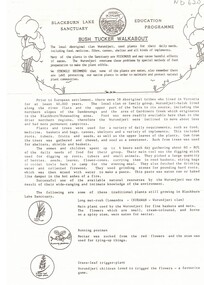
Pamphlet, Bush Tucker Walkabout, n.d
... parks & reserves blackburn lake sanctuary wurundjeri tribe ...Information sheet about plants used by the local Wurundjeri tribeInformation sheet about plants used by the local Wurundjeri tribeInformation sheet about plants used by the local Wurundjeri tribeparks & reserves, blackburn lake sanctuary, wurundjeri tribe, aboriginal clan, bush tucker, native plants, friends of the lake education programme -
 Whitehorse Historical Society Inc.
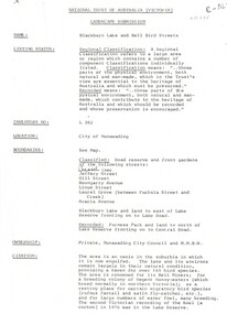
Document, Landscape Submission, c 1976
A landscape submission written for the National Trust of Australia (Victoria) for Blackburn Lake and the Bell Bird Streets.A landscape submission written for the National Trust of Australia (Victoria) for Blackburn Lake and the Bell Bird Streets. Definitions given of boundaries of the Lake area, ownership, housing and gardens. Photographs and map.A landscape submission written for the National Trust of Australia (Victoria) for Blackburn Lake and the Bell Bird Streets.blackburn lake sanctuary, waratah crescent, blackburn, jeffery street, hill street, boongarry avenue, linum street, laurel grove, acacia avenue, city of nunawading, melbourne and metropolitan board of works, furness park, camberwell grammar school -
 Whitehorse Historical Society Inc.
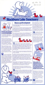
Pamphlet, Blackburn Lake Sanctuary, 1982
Pamphlet issued by the City of Nunawading on Blackburn Lake Sanctuary, its history and development.Pamphlet issued by the City of Nunawading on Blackburn Lake Sanctuary, its history and development.Pamphlet issued by the City of Nunawading on Blackburn Lake Sanctuary, its history and development.blackburn lake sanctuary, woods, john, gardiners creek, lake road, blackburn, adult deaf and dumb society, herald learn to swim drive, blackburn swimming club, city of nunawading. parks and recreation department -
 Whitehorse Historical Society Inc.
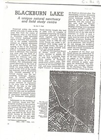
Article, Blackburn Lake, 1971
... . History and description of the lake including bird lists. parks ...'Victoria's Resources' Dec 1970 - Feb 1971 - 'Blackburn Lake: a unique natural sanctuary and field study centre - author Jean F. Field.An article from 'Victoria's Resources' Dec 1970 - Feb 1971 - 'Blackburn Lake: a unique natural sanctuary and field study centre - author Jean F. Field. History and description of the lake including bird lists. 'Victoria's Resources' Dec 1970 - Feb 1971 - 'Blackburn Lake: a unique natural sanctuary and field study centre - author Jean F. Field.parks and reserves, blackburn lake sanctuary, adult deaf and dumb society, melbourne and metropolitan board of works, walling, edna, sheddon, (mrs), (mr), bourke, nola