Showing 11853 items
matching roads for victoria
-
 Bendigo Historical Society Inc.
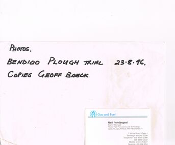
Ephemera - CASTLEMAINE GAS COMPANY COLLECTION: ENVELOPE, 23/08/1996
... Quality Assurance and Field Safety. The Address: 2 Victor Road... Road, Gate J Bentleigh Victoria 3204 - telephone (03) 95590288 ...Envelope, the words photos Bendigo plough trail 23-08-96 copies to Geoff Baeck are written on also a business card is stapled at bottom right. The business card belongs to a Neil Pendergast -Branch Manager Plastic Pipe Procedures and Technology Quality Assurance and Field Safety. The Address: 2 Victor Road, Gate J Bentleigh Victoria 3204 - telephone (03) 95590288/(03) 95590222/ Mobile 018179977/ Facsimile (03)5590294. The envelope contained 18 photos - catalogue numbers from 11518. 363 to 11518.380organisation, industry, gas and fuel -
 Glen Eira Historical Society
Article - St Mary The Virgin, Kooyong Road, South Caulfield
... Road Methodist Church, Caulfield, Victoria), date unknown...Kooyong Road, Caulfield South, Victoria, Australia... of the Kooyong Road Methodist Church, Caulfield, Victoria), date unknown ...Brief history of the Kooyong Road Church; taken from A Coming Together by Gwenda Mann and Gordon Gray, (a short account of some of the highlights of the first Fifty years of the Kooyong Road Methodist Church, Caulfield, Victoria), date unknown and photocopied. The article details the commencement of the Methodist churches circuit. Includes some history of the churches, early parishioners, the Trust Organ Fund, the removal from the Elsternwick to the new Caulfield circuit. The silver Jubilee celebrations. Article by Iris Kenatick being a local preacher in the circuit, and list of Pastors and Ministers from 1917 – 1989.kooyong road church, ontario street, catterall j. m rev., caulfield south, caulfield methodist circuit, elsternwick, hawthorn road, bambra road, eddy j. h., mclelcan mr., bundeera road, clarence street, hunt w. h., foy and gibson, balaclava, north road, penny e. r., field a. b, sunday schools, eddy mrs., field mrs., hunt mrs., leach a. g, leach mrs, levens miss, levens mr., spargo mr, spargo mrs, taylor mrs, watson mrs., festivals and celebrations, clemens v. miss, sprunt miss, bishop miss, king miss (2), cox mr, choirs, church furniture, venus street, watson amy, dodds p., oliver f. mrs, campbell h., truscott a, truscott mrs., mcgregor f. mrs, jupiter street, organs, halls, hawthorn road church, tennis courts, foundation stones, kindergartens, cricket clubs, blake e. b rev, mcgregor f. r., price c, pearson a, mahaffy j. b, hollyock e, blake mrs, aveling mrs, cripps mrs, veitch mrs, sharp w, sprunt b, hillier h. r., hillier mrs, (cousins) dulcie, cousins rowley, st mary the virgin, watson(lund) amy, millar joan, kenafick iris, governors, huntingfield lord, festivals and celebrations, clergy, church services, church festivals -
 Surrey Hills Historical Society Collection
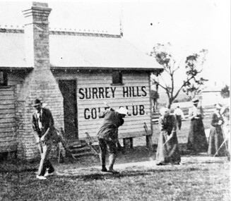
Photograph, Surrey Hills Golf Club clubhouse and players
... Road and down Victoria Crescent to where Box Hill TAFE is now... Trafalgar Street, Mont Albert to Whitehorse Road and down Victoria ...Reproduced by permission of Mr John Arnold from his book: "The Riversdale Golf Club - a history, 1892-1977." Copyright to book: Riversdale Golf Club. Surrey Hills Golf Club operated from 1892-1908 then moved and became Riversdale Golf Club. The game was played across paddocks from Trafalgar Street, Mont Albert to Whitehorse Road and down Victoria Crescent to where Box Hill TAFE is now located in Elgar Road. There were problems with cows eating the tee flags! The clubhouse still exists as 30 Trafalgar Street. The Surrey Hills Golf Club was founded by Mr Hugh W McLeod in 1894. The first president was Mr A W Harston. Mr William Meader was the first honorary secretary and the club champion for several years. Another notable identity was Mr. Harry Culliton, who contributed golf notes to "The Argus" for many years.The image is significant in documenting the Surrey Hills Golf Club which is no longer in existence.Black and white photo of a timber building with an ornamental roof ridge and brick chimney. Two men in 'plus fours' and hats and three women in long dresses and hats have golf clubs in their hands. The men and one lady are practising swings. There is a mature tree in the background with a house to the right."A group of Surrey Hills players practising in front of the clubhouse early this century. The player in the background is heading towards the first tee. The house to his right can still be seen at 3 Beatty St., Mont Albert."sports grounds, surrey hills golf club, riversdale golf club, timber building, clothing and dress, john arnold -
 Melbourne Tram Museum
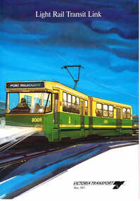
Pamphlet, Metropolitan Transit Authority (MTA), "Light Rail Transit Link", May. 1987
... extension to Glenhuntly Road. Has the Victoria Transport logo... of the system, showing a possible extension to Glenhuntly Road. Has ...Sixteen page, A4, full colour, printed on gloss paper, centre stapled pamphlet, titled "Light Rail Transit Link", describing the proposal for the conversion of the St Kilda and Port Melbourne rail lines to light rail. Dated May 1987. Has a foreword by the Minister, Tom Roper, explains the system, shows high platform stops using the Hanover example, ability to couple tramcars, development of the project, an April 1987 review of the project, transport of people with disabilities, journey times, costs and saving and two page map of the system, showing a possible extension to Glenhuntly Road. Has the Victoria Transport logo on the front of the document and the Met contact and logo on the rear. See Also Reg Item 458 for a similar pamphlet and Reg Item 1774.2 for its use in the opening folder. Two copies held.trams, tramways, minister for transport, metropolitan transit authority, st kilda, port melbourne, light rail -
 Kew Historical Society Inc
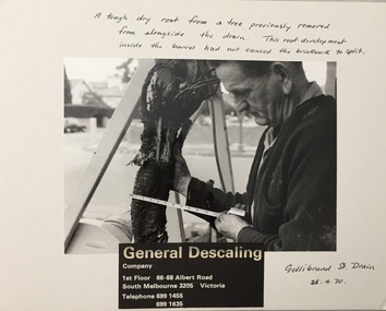
Photograph - Public Works Street Maintenance, Gellibrand Street, General Descaling, 1970
... Descaling / Company / 1st Floor 66-68 Albert Road/ South Melbourne...-68 Albert Road/ South Melbourne 3205 Victoria / Telephone 699 ...The series from which the photograph is drawn provides a snapshot by a commercial photographic studio of specific street works in Kew as well as providing examples of public works infrastructure being commissioned by local government in the 1970s. The photos originally formed part of the Engineering Department's files in the City of Kew before being donated to the Kew Historical Society.In addition to its historic importance as a record of a particular streetscape in Kew in 1970, the photograph also provides an historic record of public works by local government during the period.Public Works Street Maintenance, Gellibrand Street, Kew, Company supplied photograph of measuring a tree root in Gellibrand Street. Inscribed above photo: "A tough dry root from a tree previously removed from alongside the drain. The root development inside the barrel had not caused the brick work to split. Gellibrand St. Drain 24.4.70." Company information: "General Descaling / Company / 1st Floor 66-68 Albert Road/ South Melbourne 3205 Victoria / Telephone 699 1455 / 699 1635."general descaling, drains, gellibrand street (kew) -
 Melbourne Legacy
Postcard, Kristiana. Stortinget og Grand Hotel Postcard, c.1924
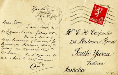
... , 235 Malvern Road, South Yarra, Victoria, Australia. Stamped... to see mum. Charl. / Mrs. C. H. Carpenter, 235 Malvern Road ...A postcard from Kristiania, which is the former name of Oslo, Norway. The title says 'Kristiania. Stortinget og Grand Hotel'. The Stortinget is the name of the parliament building, which is the building on the right of the picture. The Grand Hotel is on the left. The postmark is 1924 which is before Kristiania was renamed Oslo in 1925. The link to Legacy is not known. There are many postcards in the collection from different times and people.This postcard has an aesthetic and historical significance, the perfect handwriting shown on the back of the postcard certainly represents a significant way of traditional handwriting used at that time. Postcards were a common form of correspondence in the early 20th century.Matte finished paper postcard with a printed photo of the Stortinget and Grand Hotel in Oslo, Norway. At the back of the photo has a beatifully made handwriting specifying the message and address. Front side: Printed on photo, Kristiania. Stortinget og Grand Hotel. / 1220 Back side: Handwritten, Kristiania Norway 4 June 1924 / Dear Dode, I am back on the Lygneum and feeling OK. We are leaving here tomorrow. (Thursday for Fremantle, Adelaide, Melb and Sydney via Newcastle (Eng) and Durban. Kind Regards to all. Love to see mum. Charl. / Mrs. C. H. Carpenter, 235 Malvern Road, South Yarra, Victoria, Australia. Stamped seal, Norge 25 ore post / stamp post, Kristiania 10 VI 6 M E 1924 P . N souvenir, postcard -
 Vision Australia
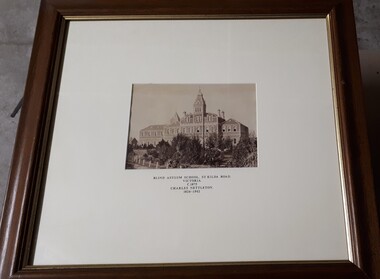
Photograph - Image, Charles Nettleton, Blind Asylum School, St Kilda Road, circa 1875
... Blind Asylum School, St Kilda Road Victoria c. 1875 Charles... Buildings Blind Asylum School, St Kilda Road Victoria c. 1875 ...Unsubstantiated photograph of the Asylum for the Blind in 1875. The four storey bluestone building rises above a group of trees planted in the garden. A picket and wire/string fence border the unpaved circular driveway. 2 black and white images of the Guiding Light at Elanora Blind Asylum School, St Kilda Road Victoria c. 1875 Charles Nettleton 1826-1902 Spencer Scott Sandilands 546 High Street, East Preson, 3181 Melbourne, Victoria, Australia, Tel: (03) 529 8011 Fax: (03) 521 1754 33 George Street, The Rocks, 2000 Sydney, New South Wales, Australia, Tel: (02) 241 4251 Fax: (02) 2414535 Rare Prints, Antiquarian Books, Old Maps, Australiana, Antiques, Photographs, Framing c.1875 Charles Nettleton School from the Blind Original Photograph $65 Guaranteed over 100 years oldroyal victorian institute for the blind, buildings -
 The Beechworth Burke Museum
Photograph, c1910
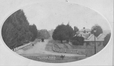
... victoria road...Taken in Beechworth c1910, this postcard depicts Victoria...Obverse: VICTORIA ROAD, BEECHWORTH Reverse: 1997.2839... Series, P.O. Box 545, G.P.O. Melbourne.” beechworth victoria road ...Taken in Beechworth c1910, this postcard depicts Victoria Road lined with trees and residential houses. A horse and buggy is also pictured driving towards the camera. This postcard was manufacture by SEMCO or SEMCO Art Needlework Company, which was a "music, post-card and fine art importers, indentors and publishers" established by Stanley Edward Mullen in c1910, Melbourne. One of the identifying features of the Semco postcards is the text printed on the reverse of the cards which read: “Semco Series, P.O. Box 545, G.P.O. Melbourne.” Black and white postcard within oval frame, grey decorative edge. Obverse: VICTORIA ROAD, BEECHWORTH Reverse: 1997.2839 (crossed-out) A02839 84-137-1 POST CARD Near our state school. BEECHWORTH about 1910 beechworth, victoria road, postcard, 1910, semco -
 Glen Eira City Council History and Heritage Collection
Kuraburn bottle
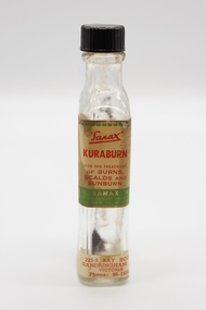
... -5 BAY ROAD, / SANDRINGHAM, S.8 / VICTORIA / Phone: 98-1604... BAY ROAD, / SANDRINGHAM, S.8 / VICTORIA / Phone: 98-1604 Clear ...This Kuraburn Bottle is part of a Sanax First Aid Case which was used at the the former Carnegie Senior Citizens' Centre. The centre was located at 314 Neerim Road, Carnegie. When the Neerim Road facility closed, its activities were moved to the Carnegie Library and Community Centre. For Occupational Health and Safety reasons, Council no longer maintains first aid kits at senior citizens' centres. Clear glass bottle with two paper labels on narrow side. One red, green, white and black label with Sanax branding, one red and white label at base of bottle with address and contact details. Black plastic screw-top lid with a section missing. Bottle has been decanted however some residue remains. Small cork stopper contained within bottle."Sanax" KURABURN / FOR THE TREATMENT / OF BURNS / SCALDS AND / SUNBURN / THE SANAX CO. / 849-51 NEPEAN HIGHWAY / MOORABIN / TEL XU 2651 / Left side of label: Directions: Dab on lightly, and repeat in two hours if necessary. Applied early, it prevents blistering. Right side of label: Allow to dry on the skin before putting on wearing apparel, to avoid staining the clothes. 223-5 BAY ROAD, / SANDRINGHAM, S.8 / VICTORIA / Phone: 98-1604 -
 Ballarat Tramway Museum
Pamphlet, Public Transport Corporation (PTC), "White Night Ballarat", Feb. 2017
... , transport map and road closures. Published by Visit Victoria...., transport map and road closures. Published by Visit Victoria. "White ...Set of two pamphlets distributed at the time for the "White Night Ballarat" Festival Saturday 4 March 2017. .1 - a grab rail pamphlet listing the bus services for the festival - piece of heavy card with a round top and a slit to enable it to be placed on a grab rail within the bus itself. .2 - 4 fold - DL sheet - titled "Give me the night" for the "White Night Ballarat" festival, with an map of the various events, messages of support, transport map and road closures. Published by Visit Victoria.trams, tramways, ballarat public transport, buses, ptv, public transport victoria, timetables, white night -
 Surrey Hills Historical Society Collection
Photograph, Surrey Hills Golf Club - the cutting in (now) Whitehorse Road, 1905, 1905
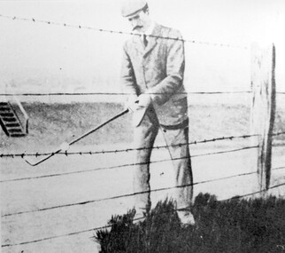
... Road and down Victoria Crescent to where Box Hill TAFE is now...Whitehorse Road, Mont Albert, Victoria... Trafalgar Street, Mont Albert to Whitehorse Road and down Victoria ...Reproduced by permission of Mr John Arnold from his book: "The Riversdale Golf Club - a history, 1892-1977." Copyright to book: Riversdale Golf Club. Surrey Hills Golf Club operated from 1892-1908 then moved and became Riversdale Golf Club. The game was played across paddocks from Trafalgar Street, Mont Albert to Whitehorse Road and down Victoria Crescent to where Box Hill TAFE is now located in Elgar Road. There were problems with cows eating the tee flags! The clubhouse still exists as 30 Trafalgar Street. The men are standing on what is now Whitehorse Road in the cutting which can still be seen near the Box Hill Motel. Walter John Carre Riddell: Born c1859; died 12 March 1930; unmarried. Father came from Riddell in Scotland and took up land at Riddell's Creek, near Gisborne. W J Carre Riddell was educated at Melbourne Grammar, graduated in law from Melbourne University in 1882 and practised law until 1907. MLA for West Bourke for 17 years. Chairman of MMBW from 1907 until retirement in 1927. Versatile sportsman. REF: Obituary in Trove - The Argus, 13 March, 1930, p8.The image is significant for its association with Walter John Carre Riddell who was a significant identity in early 20th century Melbourne. His was well-known for his sporting prowess. In early life he was a keen footballer, cricketer and tennis player. In his later years he took up golf. Was President of Royal Melbourne Golf Club and Chairman of the Victorian Golf Association. The 'coffin hole' was a notoriously difficult position to play out from.Black and white photo of 2 men, one swinging his golf club; the other carrying a golf bag and watching. They are dressed in suits and hats and are standing in a cutting, the face of which shows rock strata."W. J. Carre Riddell playing out of the coffin, 1905."sports grounds, surrey hills golf club, riversdale golf club, jon arnold, w j carre-riddell, walter john carre riddell -
 Surrey Hills Historical Society Collection
Photograph, Frank Etheridge, outside the small general store at 224 Mont Albert Road, Surrey Hills
... 292 Mont Albert Road. Electoral rolls describe Victoria May... Road Canterbury melbourne In earlier years (c1923-1943 ...In earlier years (c1923-1943), the shop was known as Mrs Sim's shop. Note that prior to c1928 the property was numbered 292 Mont Albert Road. Electoral rolls describe Victoria May Sims (nee Munday) as a confectioner but she also sold school requisites and other general household items. Her husband Harry Pascoe Sims died in 1926. The shop was taken over by Leonard William James Etheridge, whom electoral rolls and probate records variously describe as a grocer, stationer or builder. His sons Austin, Douglas and Leonard attended nearby Chatham Primary School. Leonard senior and his wife Marie Wanda (nee Chambers) lived in various locations around Surrey Hills after leaving the shop. Austin went on to establish Etheridge Ford in Ringwood.A black and white photograph of a man dressed in a suit wearing a hat. He is standing beside a car parked beside a shop.mrs sims shop, mont albert road, surrey hills, chatham school, austin etheridge, frank etheridge, victoria may sims, leonard william etheridge, douglas etheridge, leonard etheridege, marie wanda etheridge, marie wanda chambers -
 Bendigo Historical Society Inc.
Document - LONG GULLY HISTORY GROUP COLLECTION: HAPPY VALLEY ROAD
... Titled Happy Valley Road. Describes surface workings... Group - Happy Valley Road Victoria Hill Central Nell Gwynne Mine ...Titled Happy Valley Road. Describes surface workings on Victoria Hill and the different colours of the rocks, the formation of the anticlines and the synclines which are roughly parallel and run approximately north and south. They are all named and make the lines on the Bendigo Goldfield. Adjacent to Victoria Hill is the Central Nell Gwynne Mine which is on the Nell Gwynne anticline. There were quaint houses and shops in Happy Valley Road, although the shops are no longer used as such. On the right are two sketches, one an old house and below it is Heinz Butcher's Shop.bendigo, history, long gully history group, the long gully history group - happy valley road, victoria hill, central nell gwynne mine, bendigo city council, mr jack barker, william rae, heinz butcher's shop -
 Surrey Hills Historical Society Collection
Photograph, Harry Culliton at Surrey Hills Golf Club
... Road and down Victoria Crescent to where Box Hill TAFE is now...Whitehorse Road, Mont Albert, Victoria... Trafalgar Street, Mont Albert to Whitehorse Road and down Victoria ...Reproduced by permission of Mr John Arnold from his book: "The Riversdale Golf Club - a history, 1892-1977." Copyright to book: Riversdale Golf Club. Surrey Hills Golf Club operated from 1892-1908 then moved and became Riversdale Golf Club. The game was played across paddocks from Trafalgar Street, Mont Albert to Whitehorse Road and down Victoria Crescent to where Box Hill TAFE is now located in Elgar Road. There were problems with cows eating the tee flags! The clubhouse still exists as 30 Trafalgar Street. The Surrey Hills Golf Club was founded by Mr Hugh W McLeod in 1894. The first president was Mr A W Harston. Mr William Meader was the first honorary secretary and the club champion for several years. Another notable identity was Mr. Harry Culliton, who contributed golf notes to "The Argus" for many years. Harry Culliton (clerk; later bank manager) married Christina Mary Rothwell of Surrey Hills in 1897. They initially live in Canterbury Road before moving to 'Bayview' in Harding Street. They had 3 sons. The eldest Kenneth Rothwell Culliton married Molly Fanny Arthur in 1940. They continued to live in 'Bayview'. Molly was a foundation member of the Surrey Hills Historical Society.The image is significant in documenting the Surrey Hills Golf Club, no longer in existence, but also members of early Surrey Hills families. Black and white photo showing a barbed wire and post fence behind which stands a man, identified as Harry Culliton. He is wearing a suit, cap and a tie. He sports a large 'handle-bar' moustache and is gripping an iron golf club, preparing to strike a golf ball which is impaled on the barbed wire.Caption: "Harry Culliton playing from the barbed wire where his ball was impaled on the fence on the side of the coffin. To his opponent's dismay he managed to land the ball near the green and get down in two for a half."sports grounds, surrey hills golf club, riversdale golf club, clothing and dress, john arnold, harry culliton -
 Flagstaff Hill Maritime Museum and Village
Financial record - Medical Accounts, c. 1929
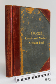
... include John Lee of St Marys Road, Wangoom. John Lee’s name has... family settled in St Marys Road, Wangoom, Victoria and have ...The accounts records in the Medical Accounts book start in February 1929 and refer to many of Warrnambool’s local names and addresses. The ledger book belonged to Dr John Hunter Henderson who conducted his medical practice from his home and surgery at Birchwood, 214 Koroit Street, Warrnambool, from 1904-1939. This particular accounts book spans from February 1929 to May 1931. Dr Henderson retired in 1939 and moved to Melbourne. His home, medical practice and many of his surgery’s items, including the Medical Accounts Book, were transferred to Dr William Roy Angus in that same year. The patients’ addresses on page 1 of the ledger include John Lee of St Marys Road, Wangoom. John Lee’s name has two entries on this page. He Grandfather, also John Lee, was a notable pioneer of the district. JOHN LEE John Lee was born in 1884 and died in 1948. His father (1845-1892) and grandfather (1814-1887) were also named John Lee. John Lee’s Grandfather, Grandmother, Father and Uncle arrived in Australia from Ireland in 1852. The colonial family settled in St Marys Road, Wangoom, Victoria and have a long association with the district. John Lee, born in 1814, is proudly listed amongst the names on the commemorative Warrnambool Pioneers Board, having arrived in Australia In 1852. In 1855 John’s Grandfather John Lee, aged 41, was head teacher of the Tower Hill School on the south bank of Tower Hill. Two years later, in 1857, the north bank of Tower Hill was surveyed and named the township of Koroit. In November of that year John Lee continued on as head master, now at the newly built Tower Hill Lake National School Number 618, on land that is now Victoria Park Recreation Reserve, on High Street, Koroit. John died in Warrnambool in 1887 but even 50 years later an ex-student wrote a letter to The Age newspaper, recalling memories of John Lee, his head master of the 1860s at the Tower Hill Lake Common School in Koroit. DR WILLIAM ROY ANGUS Doctor Angus had previously practiced in Nhill. The accounts book and many more items of Dr Angus were donated to Flagstaff Hill Maritime Village by the family of Dr Angus, Surgeon and Oculist. The Medical Accounts Book is part of the “W.R. Angus Collection” that includes historical medical equipment, surgical instruments and material once belonging to Dr Edward Ryan and Dr Thomas Francis Ryan, (both of Nhill, Victoria) as well as Dr Angus’ own belongings. The Collection’s history spans the medical practices of the two Doctors Ryan, from 1885-1926 plus that of Dr John Henderson from 1904+1939 and Dr Angus until he retired, from 1923 - 1969. The Medical Accounts Book is significant as a record of the names, addresses and health of the people in Warrnambool and District in the early 20th century. The Book is significant for its early 20th century association with two local doctors, Dr John Henderson and Doctor William Roy Angus, whose practices span from 1904-1969. The Book is also significant historically for its association with the ancestors of patient John Lee, whose Grandfather is recognised on the Warrnambool pioneer Board as one of the early pioneers in Victoria, arriving in 1852. Ledger, Medical Accounts Book. Title is Bruck’s Condensed Medical Account Book. Book has hardback, green cover, bound and reinforced with red leather and printed title in gold lettering. The pages of index tabs in the beginning of the book have no entries. The first page of the accounts section of the book have the hand written heading “February 1929”. The book continues until the end of May 1931. Inside both front and back cover are hand written notes in different scrips. Both black and blue ink has been used. The book belonged to Dr John Hunter Henderson. It is part of the W.R. Angus Collection."Bruck’s Condensed Medical Account Book"flagstaff hill, warrnambool, shipwrecked coast, flagstaff hill maritime museum, maritime museum, shipwreck coast, flagstaff hill maritime village, great ocean road, medical treatment, medical history, medical accounts, medical administration, medical record 1929, ledger, bruck’s condensed medical account book, john hunter henderson, william roy angus, edward ryan, thomas francis ryan, john lee, tower hill school, tower hill lake national school, koroit primary school, victoria school 628, st marys wangoom, warrnambool pioneer, birchwood, 214 koroit street warrnambool -
 Kew Historical Society Inc
Photograph - Snow-covered road near Bogong, c.1926
... or road near Bogong in Victoria in the mid-1920s.... or road near Bogong in Victoria in the mid-1920s. Photograph Snow ...Henry Beater Christian (1886-1962) , was a descendant of one of the earliest settler families in Kew. Employed at the Kew Asylum as a 'public servant', he was a skilled amateur photographer, photographing numerous scenes in Kew and on his travels around Victoria. The majority of his photographs date from 1916 to 1929. His finest photographs are housed in two photograph albums. Digital copy of a photograph from page 34 of the 47-page photograph album containing 261 gelatinous silver images, loaned by Diane Washfold with permission given to digitise and hold a copy in our collection. John Chapman has written in 'Bushwalking Clubs - A Brief History', about the establishment in Victoria of the first bushwalking club in 1888, and the popularisation of bushwalking during the interwar period. Henry Christian's 'walks' appear to have been undertaken solely or with a companion/s. This black and white photo is part of a group of photos taken in the Victorian High Country. The page is labelled 'Bogong ****' and includes photos of landscapes, individuals, and built structures. This small black and white photo is of what appears to be a snow-covered track or road near Bogong in Victoria in the mid-1920s."BOGONG [illegible]"henry beater christian (1886-1962), landscape photography, christian-washfold collection, photograph albums, bushwalking, northeast victoria, victorian high country, bogong -
 Bendigo Military Museum
Postcard - POSTCARDS, PHOTOGRAPHIC WW1, Edgar Dawson collection : Battalion comrades, 1915-1919
... 1. On verso "L.Cpl J Richards, St Killians Road, White... 1. On verso "L.Cpl J Richards, St Killians Road, White Hills ...This six-postcard group is the third in a series of records of items in the collection of Edgar Dawson DCM. Dawson was the Regimental Sergeant Major of 57th Battalion, AIF. The 57th had a company of men largely from Bendigo and Eaglehawk. These postcards are from his personal album. Many are annotated in Dawson's hand with explanatory notes on the subject. Refer to Cat No 893 for his service details. Items originally in album cat. no. 207P Service details available through the NAA. Physical description Collection of six photo postcards B+W 1. Portrait of Richards, John 3593 57th Btn 2. Portrait of Moore, Charles 4593 57th Btn 3. Portrait of Mitchell, Leslie Fenen 4854 57th Btn 4. Portrait of Hutson, Herbert Spence 3540 57th Btn 5. Portrait of Steele, Leslie William 2737 57th Btn 6. Portrait of Spinks, William Edward 2239 57 Btn1. On verso "L.Cpl J Richards, St Killians Road, White Hills Bendigo Victoria 6-10-17" 2. On verso, "Chas Moore, 9-9-17" 3. On verso "Pt L.F. Mitchell, No 4854, 13th reinforcements, 29th Battalion, AIF Abroad" 4. On verso "This is one of our gallant runners France 1917" "Herbert S. Hutson, Lemon Grove, Heathcote Victoria" 5. On verso "With best wishes L Steele 10-2-18", "L. Steele, Balmoral Street, Essendon, Melbourne Australia" 6. On verso "W.E.Spinks, Templeton Street, Euroa, Victoria, Australia"postcards, 57th battalion, edgar dawson dcm -
 Bendigo Historical Society Inc.
Map - Three Road Maps of Bendigo, 1962
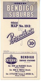
... , Victoria, son of George Adam Broadbent, Lancashire-born draper.... Next year he issued a road map of Victoria, 'prepared … after ...George Robert Broadbent (1863-1947), cyclist and map publisher, was born on 3 November 1863 at Ashby near Geelong, Victoria, son of George Adam Broadbent, Lancashire-born draper, and his wife Elizabeth, née Ruffhead. When the family moved to North Melbourne Broadbent attended the Errol Street school, followed his father's trade, and became an early cycling and cycle-racing enthusiast. At various times Broadbent held most Victorian and Australian road records, and two of his performances on solid tyres—203 miles (327 km) in 24 hours on a penny farthing, and 100 miles (161 km) in 6 hours 20 minutes on a 'safety' bicycle—were never bettered. He established records for all distances between 130 and 220 miles (209 and 354 km), and for all times between 8 and 12 hours, at the Exhibition Grounds track in May 1894, and road records for 50 and 100 miles (80 and 161 km) in October 1896. The Australian Cyclist acknowledged him 'the finest road rider that Australia has ever produced'. A foundation councillor of the League of Victorian Wheelmen in October 1893, Broadbent contested the first Warrnambool-Melbourne race in 1895, and was active in the Good Roads Movement. Next year he issued a road map of Victoria, 'prepared … after some sixteen years riding and touring in all parts of the Colony', which indicated general topography, distances, and roads classified as 'good', 'fair' or 'ridden with difficulty'. It was to become Victoria's standard map, and the basis of a continuous publishing programme by Broadbent's Official Road Guides Co.Three Road Maps of Bendigo, Bendigo and Suburbs, Bendigo and Eaglehawk. Two fold out maps printed in colour and produced by Broadbent's Road Maps Pty. Ltd. 475 Collins Street Melbourne. One map printed by Bolton's Bendigo.history, bolton's, bendio broadbent maps -
 Orbost & District Historical Society
black and white photograph, 1913
... of the main roads of the state of Victoria. Because... of the main roads of the state of Victoria. Because ...This photograph shows Country Roads Board men clearing a bush track at Hospital Creek. Their vehicle was bogged. The y Roads Board was formed in 1913 1910 it had become apparent that there was a need for a central roads authority to take over responsibility from the Board of Lands and Works for the care and management of the main roads of the state of Victoria. Because there was no consistent and systematic policy for road maintenance Victorian roads were in a deplorable condition. At this time the use of the motor car accentuated the demands for better roads. As a result of these needs the Country Roads Act 1912 was proclaimed in 1913 providing for the establishment of the Country Roads Board as a central road authority with responsibility for those roads within the State considered to be main roads. the C.R.B. was responsible for the construction of roads and bridges including the Snowy River road bridges in Orbost.. This is a pictorial record of transport difficulties in East Gippsland in early 20th century.A large black / white photograph of three men clearing a bush track with a motor vehicle behind them.transport roads road-maintenance country-roads-board -
 Warrnambool and District Historical Society Inc.
Booklet - Warrnambool Visitor's Handbooks 1979-2024, Collett, Bain and Gaspar, Printers, 1979-2014
... of Victoria's Shipwreck Coast on Australia's Great Ocean Road [.7... Ocean Road; You'll love every piece of Victoria; Visitors ...This is a collection of eight Warrnambool Visitor handbooks produced between 1979 and 2014 by the City of Warrnambool Tourist Information Centre. They contain maps of Warrnambool, lists of services, accommodation and tourist attractions as well as many advertisements for local businesses.These handbooks give a useful snapshot of businesses and tourist attractions in Warrnambool for each of the years covered. (1979, 1980, 1986, 1990, 1993, 1994, 1995, 2014)[.1a] A 48 page booklet with white pages and blue printing. The front cover has a coloured photograph of Flagstaff Hill with boats on a man made lake in the foreground looking across Lake Pertobe toward South Warrnambool. [.1b] A coloured bifold brochure. The front cover has a fisherman on a cray-boat holding a crayfish in the lower section. The top quarter has a blue back ground with white printing. The rear cover is red and has small photos of the Hopkins River and the Framlingham Forest. [.2] A 48 page booklet with white pages and black printing. The front cover is white with black writing on the left hand side and a colour photograph of the Loch Ard peacock. The Warrnambool Premier Town stylised logo of seven Norfollk pines above blue waves is in the top right hand corner. There is a blank ink Warrnambool Library stamp underneath the logo. The rear cover has photographs of The Twelve Apostles and the Hopkins Falls and the Premier Town Logo [.3] A 40 page booklet with mainly black printing on white paper. There are three fold out maps of Warrnambool and the surrounding district. The glossy cover has a black background with a colour photograph of the Twelve Apostles taken at sunset. The rear cover has three small of Proudfoot's boathouse on the Hopkins River, Flagstaff Hill, and the main beach area. The front cover has black writing inside to peach coloured rectangles. The inside rear cover has a fold out coloured tour map of Western Victoria. [.4] A 40 page booklet printed on glossy white paper with coloured photographs and black and red printing. The front cover has a photograph of The Twelve Apostles surrounded by a white border. There is red writing in the upper border. There is a sandy coloured writing superimposed across the bottom of the photograph and a Victoria's Shipwreck Coast logo in the bottom right hand corner. [.5] A 44 page booklet printed on white paper with black printing. The cream coloured cover has a pale red rectangle with blue writing on the right hand facing edge and includes two stylised Norfolk pines and with waves underneath. There is is an intersecting blue rectangle with cream printing. [.6] A 48 page booklet printed on white paper with black printing. The cover is brown with a cream vertical strip containing black writing on the right hand side. There is a stylised map from Geelong to Mount Gambier showing the Great Ocean Road across the cover. [.7] A 48 page booklet printed on white paper with black print. The glossy colour cover has a photograph of a Southern Right whale fluke. There is white printing on a the blue background of the sky and sea. The bottom left hand side of the front cover has a Tourism Victoria logo made of jigsaw puzzle pieces. The back cover has a stylised coloured map of The Great Ocean Road located in a white rectangle at the top of the page. Within the rectangle is a small map of Australia locating Victoria and the part of Victoria covered by the map. [.8] A 64 page A5 coloured booklet printed on white pages with black print. The white front cover has black and grey print with a colour photograph of two people holding coffee cups watching four race horses being exercised on the beach and in the water of Lady Bay in the early morning. The bottom right hand corner has a Tourism Victoria logo. The rear cover has a mainly blue back ground with a pink orange and green colour splats contains words advertising the 2015 Fun 4 Kids Festival [.1a] Warrnambool The Heart of Victoria's Great Southwest Visitor's Handbook [.1b] Warrnambool City for all seasons; The Heart of Victoria's Great Southwest [.2] Warrnambool visitor's handbook Warrnambool Premier Town 1979-1982 [.3] Warrnambool Handbook Victoria [.4] Warrnambool The Shipwreck Coast [.5] Welcome to Warrnambool Warrnambool Visitors Handbook 1993-1994 [.6] Welcome to Warrnambool Visitors Handbook 1994-95 Rear cover: Warrnambool Centre of Victoria's Shipwreck Coast on Australia's Great Ocean Road [.7] Warrnambool Shipwreck Coast - Great Ocean Road; You'll love every piece of Victoria; Visitors Handbook [.8] Warrnambool Great Ocean Road Official Visitor Guide; It's a wonderful Warrnambool; You'll love every piece of Victoria visitvictoria.com. Rear Cover Live entertainment.Workshops.Creativity.Action 28 June - 5 July 2015 Australia's Best Children's Festival F4K The ultimate winter school holiday adventure Fun 4 kids festival Warrnambool For more information visit Fun4kids.com.au Warrnambool great Ocean Road Victoriawarrnambool, visitor handbooks, tourist information guides, warrnambool maps -
 Kew Historical Society Inc
Plan - Subdivision Plan, Myrtle Park Estate, City of Camberwell, 1916
... by Victoria Road (now Lansdowne Street), Buchanan Avenue and Dight...’ was a subdivision bounded by Victoria Road (now Lansdowne Street), Buchanan ...The Kew Historical Society collection includes almost 100 subdivision plans pertaining to suburbs of the City of Melbourne. Most of these are of Kew, Kew East or Studley Park, although a smaller number are plans of Camberwell, Deepdene, Balwyn and Hawthorn. It is believed that the majority of the plans were gifted to the Society by persons connected with the real estate firm - J. R. Mathers and McMillan, 136 Cotham Road, Kew. The Plans in the collection are rarely in pristine form, being working plans on which the agent would write notes and record lots sold and the prices of these. The subdivision plans are historically significant examples of the growth of urban Melbourne from the beginning of the 20th Century up until the 1980s. A number of the plans are double-sided and often include a photograph on the reverse. A number of the latter are by noted photographers such as J.E. Barnes.The ‘Myrtle Park Estate’ was a subdivision bounded by Victoria Road (now Lansdowne Street), Buchanan Avenue and Dight Avenue. Other streets that were created by the subdivision included Eurolie Street, Boorahman Street and Moody Street (now Sylvan Street). The Estate took its name from Myrtle Park (later changed to Macleay Park), which had been created in 1923 by Camberwell Council. The Park adjoined the southeast corner of the new subdivision. The Estate included 74 regular allotments characterised by narrow frontages and long blocks. Confusion may have greeted prospective purchasers as the Estate was advertised in the daily newspapers as being in East Kew, rather than in Camberwell, where it was at that stage located.subdivision plans - balwyn, myrtle park estate - camberwell [surrey hills] -
 Phillip Island and District Historical Society Inc.
Photograph - Post Cards, Rose Series et al, Early 20th Century
... P674 The Beach Road Cowes Phillip Island Victoria". Right side... Series P674 The Beach Road Cowes Phillip Island Victoria". Right ...One of 15 A3 pages with copies of postcards on each page. From The Shirley Jones Collection.Copies of Postcards: Left side from top to bottom: View of Phillip Island from San Remo Jetty. The Beach at Rhyll, Phillip Island. The Isle of Wight Hotel, Cowes, Phillip Island. The Beach Road at Cowes, Phillip Island. Right side from top to bottom: The Isle of Wight Hotel, Cowes, Phillip Island. View at Rhyll, Phillip Island. Man of beach at Eastern Rocks Phillip Island, Forest Reserve Cowes, Phillip Island.Left side from top to bottom. Photograph 1 - "Phillip Island from San Remo" Photograph 2 - "The Rose Series P 3431 The Beach Rhyll Phillip Island Vic". Photograph 3 - "Isle of Wight Hotel Cowes Phillip Island". Photograph 4 - "The Rose Series P674 The Beach Road Cowes Phillip Island Victoria". Right side from top to bottom. Photograph 1 - "Photo Shop Series, Isle of Wight Hotel Cowes". Photograph 2 - "The Rose Series P3419 View at Rhyll Phillip Island Vic.". Photograph 3 - "Eastern Rocks (Smiths Point) Phillip Island" Message written on the side. Photograph 4 - "Forest Reserve Cowes".the isle of wight hotel cowes phillip island, sand remo jetty, jetty san remo, rhyll phillip island, beach road cowes, eastern rocks smiths point phillip island, forrest reserve phillip island, shirley jones collection, thelma astbury -
 Flagstaff Hill Maritime Museum and Village
Container - Horse trough, Annis & George Bills, circa Dec. 1932
... in Victoria and New South Wales. It is estimated that over that time... in Victoria and New South Wales. It is estimated that over that time ...This horse trough is the only survivor of the two troughs originally installed in Raglan Parade, Warrnambool, in 1932. It was later moved to the Pony Club at Albert Part, near the north corner of Coulstock and Craig Streets. Over the time there its purpose was changed from a horse watering trough to a colourful garden bed of agapanthus plants. By February 2013 the horse trough had been transferred to Flagstaff Hill for display in the Maritime Village’s grounds. This trough is one of hundreds provided by the Annis and George Bills Estate Trust since 1927 for the welfare of working horses and dogs. The original concrete cap over the small compartment is still retained. There are also markings on the right side of the trough where it probably had a birdbath, tap or a dish for the horseman’s dog, similar to other troughs donated elsewhere by the Trust. Less than half of the troughs produced for the Annis and George Bills Trust still survive. In 2017 Felicity Watson, National Trust Victoria’s advocacy manager, said that the troughs were treasures and becoming rare, with more than a dozen across Victoria now being heritage protected. ABOUT ANNIS AND GEORGE BILLS The 1927 Will of George Bills included setting up the Annis and George Bills Estate Trust, which provided for hundreds of horse troughs to be supplied and installed throughout Australia, Britain, USA and other parts of the world for the welfare of horses. Town and city councils could apply to the Trustees for a horse trough for their communities. George “Joe” Bills was born in Brighton, England, in 1859. The family migrated first to New Zealand then to Australia in 1873, settling in the Echuca-Moama district. George moved to Brisbane in 1882 where he met Annis Swann, formerly from Sheffield. Both were animal lovers. George and Annis married 1885 and moved to Sydney to join George’s brother Henry in his mattress wire weaving business, later known as the Bills Brothers. They patented their own machine in 1893 and the business became very profitable. George was able to donate to charities that supported his passion to improve animal welfare. He and Annis joined the Victorian Society for the Protection of Animals and in 1924 George received a Life Membership with the RSPCA. George retired in 1908. The couple moved to Hawthorn, Victoria, in 1910, where they donated troughs for the work horses of Melbourne. During a visit to England Annis passed away. In 1927 George moved from Hawthorn to Camberwell, where he passed away at the end of that year. George had requested in his Will that a trust fund be set up from his estate "…construct and erect and pay for horse troughs wherever they may be of the opinion that such horse troughs are desirable for the relief of horses and other dumb animals either in Australasia, in the British Islands or in any other part of the world subject to the consent of the proper authorities being obtained." The troughs were to bear a plaque inscribed “Donated by Annis and George Bills, Australia”. In 1927 the cost to make a trough was about £13 (which converts to about $1079 in 2020 ), plus transport and installation costs. Most of the troughs were installed between 1930 and 1939 in Victoria and New South Wales. It is estimated that over that time around 500-700 Bills Horse Troughs were installed in Australia and another 50 overseas. Most of the troughs made in Victoria had three moulded front panels like this trough, and no panels moulded on the rear, whereas troughs made in NSW had four panels on the front and five on the back. Victorian troughs were made by a Bills’ relative, J H Phillips. Later, other manufactures for the Trust’s troughs included Rocla Concrete Pipes Ltd, in Auburn Road, Hawthorn, Victoria, who produced to the same original design. No further troughs produced after the end of World War II. A memorial to Annis and George Bills was first erected in Hawthorn in 1929. It included a drinking fountain and a dog dish. Its current location is unknown. In 1964 the George Bills RSPCA Resource Centre opened in Burwood East. This Bills horse trough is nationally significant as one of the surviving examples of the standard Bills memorial horse troughs that still has its compartment cap and evidence of it once having had attached fittings, possibly for a birdbath or dog dish. This trough has State historical significance for being produced in the early 1930s by a business in Hawthorn, Victoria. This example of a Bills horse trough is significant for being in comparatively good condition. The trough is locally significant for being the sole survivor of the two Bills horse troughs installed in the City of Warrnambool in 1932, originally installed on Raglan Parade and continued to be used in the community at the Pony Club, then finally transferred to its current location at Flagstaff Hill by early 2013. It is culturally significant as it represents the community’s dependence on horses for travel and transportation previous to motorised vehicles. It is morally significant as a generous gift from a couple concerned with the welfare of animals.Horse trough; a long narrow rectangular container used for storing water. Trough is made from pre-cast concrete with one large open compartment and a small covered compartment. The base of the small compartment is raised slightly above the base of the trough and is covered by a removable concrete cap. The design of the front of the trough includes three panels moulded into it that align with the shape of the back pediment (panel). The pediment is shaped with side arcs that step up to a wide centre arc. A rectangular concrete plaque is cast into the centre of the pediment and is engraved with the names of the original donors, Annis and George Bills. The trough was made in Hawthorn, Victoria, by J H Phillips circa 1932. “DONATED BY / ANNIS & GEORGE BILLS / AUSTRALIA”flagstaff hill, warrnambool, shipwrecked coast, flagstaff hill maritime museum, maritime museum, shipwreck coast, flagstaff hill maritime village, great ocean road, annis and george bills, bills trust, j h phillips, rocla concrete pipes ltd, hawthorn, water trough, watering trough, horse trough, animal welfare, bills horse trough -
 Orbost & District Historical Society
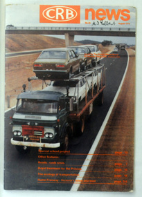
magazine, CRB News, August 1976
... for a central roads authority to take over responsibility from the Board... for a central roads authority to take over responsibility from the Board ...By 1910 it had become apparent that there was a need for a central roads authority to take over responsibility from the Board of Lands and Works for the care and management of the main roads of the state of Victoria. Because there was no consistent and systematic policy for road maintenance Victorian roads were in a deplorable condition. At this time the use of the motor car accentuated the demands for better roads. As a result of these needs the Country Roads Act 1912 was proclaimed in 1913 providing for the establishment of the Country Roads Board as a central road authority with responsibility for those roads within the State considered to be main roads. the C.R.B. was responsible for the construction of roads and bridges including the Snowy River road bridges in Orbost. This was a major project involving not only a new bridge over the Snowy River (including Lochiel Lagoon), but other bridges over Ashby’s Gulch and Watt’s Gulch. These new bridges were opened in November 1976 with the unveiling of a plaque on the eastern end of the $2.4M Snowy River Bridge. (ref. May Leatch) This is a useful reference tool on the history of the construction of the Snowy River road bridges.A journal, titled "CRB News" . On the front cover the title is in orange print with No. 33 August 1976 above a coloured photo of a truck carrying two tiers of new vehicles along a main sealed road. It contains information and photos of the construction of the Snowy River road bridges.on front cover - handwritten in black - "M. I. Gilbert"crb-news country-roads-board snowy-river-road-bridges -
 Ballarat Tramway Museum
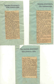
Newspaper, Geelong Advertiser, "One Man Trams", "Tram-men's Protest", "Road Operators' Meeting", 27/10/1952 12:00:00 AM
... . "Road Operators' Meeting", about a proposed meeting of road... of the Road Transport Development Association of Victoria on 28 ...Yields information about industrial issues in Geelong over one man trams and rosters, and that Ballarat was keep advised of the situation.Set of three (two copies of each), newspaper clippings from the Geelong Advertiser, 27/10/1952 cut out and pasted onto blue paper, with the Newspaper Name and date type on each piece. News items were: "One Man Trams" - quoting Mr. T. A. Farr, Manager SEC Geelong re the proposed introduction of one-man trams. alterations to through routing and effects of this. "Tram-men's Protest" - resolution passed against proposed new roster, one-man trams, quotes union Secretary Mr. C. McDonald, and details of the resolution. "Road Operators' Meeting", about a proposed meeting of road operators to form a Geelong Sub-branch of the Road Transport Development Association of Victoria on 28 October. Over 250 invitations sent out. Quotes the president Mr. S. V. Leslie.one man trams, geelong, unions, rosters, road transport -
 Whitehorse Historical Society Inc.
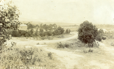
Photograph, L L Road Vermont, late 1800
... Victoria Road Northcote and was posted at the Fairfield Post Office... by Muriel at 37 Victoria Road Northcote and was posted ...Dr L L Smith was a pioneer of the Vermont District. He owned 250 acres in the area bounded by Boronia, Canterbury and Heatherdale Roads and the creek. The property was known as L L Vale after which the road was named. Name was changed to Boronia Road in later years. He was a Doctor with rooms in the City, was a member of Parliament.Sepia Postcard of L L Road, Vermont (now Boronia Road) taken in the early 1900s (card is postmarked 27 Aug 1909). Shows the road going down it is presumed to the creek. It is possible that the house is that of Dr.L.L.Smith. See History.|Orchard in background is the Finger orchard. (from Mr. Shambrook - Tim's father)|Information on the back of the Postcard reveal it was sent to Miss Roberts of 61 Hoddle Street Richmond Victoria by Muriel at 37 Victoria Road Northcote and was posted at the Fairfield Post Office Victoria on 27 August 1909. Text is 'Dear Ethel Just a Post Card to let you know I will be out to see you on Monday if convenient. I came down with Mr Hutchinson and he asked me what were we laughing out on the Sunday when he came up. Muriel|See the following references -ND199, 313, 539. 1242, 2013, 3680 & 4295.l l road vermont, boronia road vermont, smith . l l dr -
 Melbourne Tram Museum
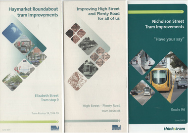
Pamphlet, VicRoads, "Haymarket Roundabout tram improvements", 2009 and 2011
... Brunswick Road / Holden St and Victoria Parade. Has a drawing... and Plenty Road for all of us", detailing the proposal for central ....1 - Pamphlet - DL six fold printed on recycled paper, with one half designed as a feedback form with postal address titled "Haymarket Roundabout tram improvements" showing traffic control works and installation of platform stops. Has a drawing of the proposals, photos and contract details. Part of the Think Tram project. Issued by Yarra Trams and VicRoads, June 2011. Two copies held. .2 - Pamphlet - DL six fold - printed on recycled paper titled "Improving High St and Plenty Road for all of us", detailing the proposal for central island platform stops and kerb extensions stops, part time tram lanes and project timing - three states. Not dated, but notes a May 2011 start proposal. Part of the Think Tram project. Issued by Yarra Trams and VicRoads and City of Darebin. Two copies held. .3 - Pamphlet - DL four fold - printed on gloss paper, titled "Nicholson Street Tram Improvements", showing proposals for tram lanes, no right turns, locations where U turns could be done and traffic signal works between Brunswick Road / Holden St and Victoria Parade. Has a drawing of the proposals, photos and contract details. Part of the Think Tram project. Issued by Yarra Trams and VicRoads, June 2009.trams, tramways, high st, preston, haymarket, platform stops, tram stops, nicholson st, road works -
 Ballarat Tramway Museum
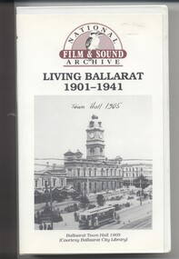
Film - Video cassette tape and box, Chris Long, "Living Ballarat 1901 - 1941", 1990
... , Bridge St, Sturt St, arches, Main Road, Council Road Roller..., Bridge St, Sturt St, arches, Main Road, Council Road Roller ...Yields information through movie films of the 1960's of Ballarat trams operating in the streets of Ballarat and has a strong association with the maker - National Film and Sound Archives and Chris Long.Video cassette in a plastic case, titled "Living Ballarat - 1901 - 1941, National Film and Sound Archive (1990)". See Reg item 4519 for the DVD version. The DVD was made by Peter Winspur using this tape. Transferred to the Hard Drive 11/1/2010- AV Files - dB text/AV Files/Reg Item 4519/Video_TS (at 12/1/2010) Copyright provisions - National Film and Sound Archive - segments may not be used without their permission, viewing only. Synopsis: based on time - 0.00 - intro, 1901 film, Melbourne, first film in Ballarat, Royal visit to Ballarat, Boer War Monument, first feature length film in Ballarat. 2.50 - Bridge St and Sturt St scenes, filmed from a flat truck pushed by an electric tram, including No. 11 going to City Oval to Lydiard St. 5.00 - Sturt St Military parade, with trams in background and tram running alongside. 6.54 - scene of Alfred Hall and films. 7.32 - scene on Lake Wendouree and paddle steamer - Living Ballarat film - Pathe's Ballarat Gazette local film unit, football ground scene. a children's beauty competition, tree planting at Macarthur St state school, 1911 Ballarat Show, unveiling of the Boer War statue name plates, Lake Wendouree 1912. 13.22 - St Patricks David Pde with trams in the background. 14.24 - Ballarat Kennel club dog show. 15.50 - Royal visit in 1920, Arch of victory opening 17.48 - Day at Macarthur St state school and tree plantation 20.55 - Bakery Hill - Stones Corner with tram tracks, cars, little trams, Sturt St with a tram leaving Grenville St, ESCo 9 turning from Lydiard St to run down to Grenville St. 22.15 - Ballarat Show, Coliseum Hall, 1925, races, machinery shows, boxing troupe. 25.20 - Botanic Gardens Gates, Lake Wendouree area. 25.30 - Gem Picture travelling show - film 26.16 - Formal visit of English pressman to Ballarat, 1925, Botanic Gardens, Eureka Stockade, Avenue of Honor, Moorabool Reservoir. 29.15 - 1927 Fed Govt doco of Ballarat, Black Hill, 1927 Home to Ballarat Festival, Ballarat Commemorative song, Craigs Hotel, Ballarat Post Office, tram centre poles in Lydiard St, tram climbing Sturt St, Town Hall, tram at Lydiard St terminus coursing, 8, Sturt St, view of ESCo Sebastopol car leaving Grenville St, Selkirks Brickworks, the Welcome nugget, Peter Lalor statue, Eureka stockade, sewerage plant, modern housing, Sturt St west, water supply - golf club, the High School, the orphanage, fine homesteads around Ballarat, Lake Wendouree. 41.00 Opening of the Ballarat Aerodrome. 43.11 - Depression work and leading into radio broadcasting - 3BA open 1930, typewriters, radio transmission equipment, radio aerials, boys listening to crystal sets 47.50 - Bluebirds Children session tour to the Gardens, mentions the BTPS, trams 13, 3? and 14 carrying visitors arriving and getting off and picnic. 48.50 - expansion of 3BA transmitter capacity 51.30 - 1934 visit of the Duke of Gloucester - visit to the Lucas factory, views of the work floor and the factory history and then South St band competition at the Showgrounds. 55.10 - South St Music Festivals, Coliseum and fire. 56.25 - Ballarat Floral Festival March 1938 - Victorian Railways arch of welcome. 57.25 - segment in the shot of 12 and 19? in Sturt St 57.45 - colour segment of the festival, 58.39 - Grenville St tram shelter, Bridge St, Sturt St, arches, Main Road, Council Road Roller, Victoria St, Eureka Stockade Reserve, Botanic Gardens, setting up the flowers, wax papers. 1.01.48 - decorated tram, north side of Sturt St, details of the materials used, Crockers. 1.03.20 - Hospital Fund Raising Gala Day - March 1938, special trains arriving Ballarat Railway Station, fund raising procession, pageant at the Showgrounds, fly past. 1.07.35 - 1939 Summer, motor cycle races at Learmonth, City Oval fire brigade demonstrations, Ballarat (East) Fire Station decorated for the 1939 Floral Festival with tram in the background and No. 29, Floral Tram and others. 1.09.25 - July 1914 - Ballarat at War parade, troops. 1.10.10 - credits. Box has images of a tram and town hall on the front and details of the contents on the rear and who made it etc. See images for details. ballarat, 3ba, floral tram, royal visit, buildings, esco -
 Flagstaff Hill Maritime Museum and Village
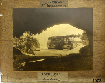
Photograph - Coastal Scene, Foyle Photographic Studio, Loch Ard Gorge Port Campbell, 1889-1919
... Ard Gorge, which is located along the Great Ocean Road...Liebig Street, Warrnambool, Great Ocean Road, Victoria... Road in Victoria, near Port Campbell. The gorge is named after ...The photograph shows the popular tourist attraction, Loch Ard Gorge, which is located along the Great Ocean Road in Victoria, near Port Campbell. The gorge is named after the famous sailing ship, the LOCH ARD, that was wrecked there in 1878. Only two of the 54 passengers and crew survived. FOYLE “Foyle” written on the photograph is the name of Foyle’s Photographic studio. At the time of the photograph, the studio was owned by both Charles and Lilian Foyle (sometimes known as Lillian or Lily), either of whom could have taken this photograph. They also worked together at a later date on the photographs, sketches and paintings of the famous and historical Pioneers’ Honour Board, which is currently on view in the Warrnambool Library. Foyles Photography was the studio of James Charles Foyle. He owned “Foyle’s Photo Card Studios” in Liebig St, Warrnambool, which operated between 1889 – 1919. A letter to the editor (by Mr Edward Vidler) in the Melbourne Argus, 3rd August 1907, mentions that in that year Warrnambool would celebrate the 60th anniversary of its proclamation as a town, and that talented local artist Miss Lily Foyle would paint 200 portraits in watercolour of the pioneers who settled in the district prior to 1860. The Pioneer Honour Board can still be seen on display in the Warrnambool Library. In the Warrnambool Standard, Dec. 1917, “Mr Foyle’s studio was awarded the contract to decorate rail cars on newly opened Trans-Continental railway, assisted by his sister, Miss Findlay.” HISTORY OF THE LOCH ARD The LOCH ARD belonged to the famous Loch Line which sailed many ships from England to Australia. Built-in Glasgow by Barclay, Curdle and Co. in 1873, the LOCH ARD was a three-masted square-rigged iron sailing ship. The ship measured 262ft 7" (79.87m) in length, 38ft (11.58m) in width, 23ft (7m) in depth and had a gross tonnage of 1693 tons. The LOCH ARD's main mast measured a massive 150ft (45.7m) in height. LOCH ARD made three trips to Australia and one trip to Calcutta before its final voyage. LOCH ARD left England on March 2, 1878, under the command of Captain Gibbs, a newly married, 29-year-old. She was bound for Melbourne with a crew of 37, plus 17 passengers and a load of cargo. The general cargo reflected the affluence of Melbourne at the time. Onboard were straw hats, umbrella, perfumes, clay pipes, pianos, clocks, confectionary, linen and candles, as well as a heavier load of railway irons, cement, lead and copper. There were items included that intended for display in the Melbourne International Exhibition in 1880. The voyage to Port Phillip was long but uneventful. At 3 am on June 1, 1878, Captain Gibbs was expecting to see land and the passengers were becoming excited as they prepared to view their new homeland in the early morning. But LOCH ARD was running into a fog which greatly reduced visibility. Captain Gibbs was becoming anxious as there was no sign of land or the Cape Otway lighthouse. At 4 am the fog lifted. A man aloft announced that he could see breakers. The sheer cliffs of Victoria's west coast came into view, and Captain Gibbs realised that the ship was much closer to them than expected. He ordered as much sail to be set as time would permit and then attempted to steer the vessel out to sea. On coming head-on into the wind, the ship lost momentum, the sails fell limp and LOCH ARD's bow swung back. Gibbs then ordered the anchors to be released in an attempt to hold its position. The anchors sank some 50 fathoms - but did not hold. By this time LOCH ARD was among the breakers and the tall cliffs of Mutton Bird Island rose behind the ship. Just half a mile from the coast, the ship's bow was suddenly pulled around by the anchor. The captain tried to tack out to sea, but the ship struck a reef at the base of Mutton Bird Island, near Port Campbell. Waves broke over the ship and the top deck was loosened from the hull. The masts and rigging came crashing down knocking passengers and crew overboard. When a lifeboat was finally launched, it crashed into the side of LOCH ARD and capsized. Tom Pearce, who had launched the boat, managed to cling to its overturned hull and shelter beneath it. He drifted out to sea and then on the flood tide came into what is now known as LOCH ARD Gorge. He swam to shore, bruised and dazed, and found a cave in which to shelter. Some of the crew stayed below deck to shelter from the falling rigging but drowned when the ship slipped off the reef into deeper water. Eva Carmichael had raced onto the deck to find out what was happening only to be confronted by towering cliffs looming above the stricken ship. In all the chaos, Captain Gibbs grabbed Eva and said, "If you are saved Eva, let my dear wife know that I died like a sailor". That was the last Eva Carmichael saw of the captain. She was swept off the ship by a huge wave. Eva saw Tom Pearce on a small rocky beach and yelled to attract his attention. He dived in and swam to the exhausted woman and dragged her to shore. He took her to the cave and broke and opened the case of brandy, which had washed up on the beach. He opened a bottle to revive the unconscious woman. A few hours later Tom scaled a cliff in search of help. He followed hoof prints and came by chance upon two men from nearby Glenample Station three and a half miles away. In a state of exhaustion, he told the men of the tragedy. Tom returned to the gorge while the two men rode back to the station to get help. By the time they reached LOCH ARD Gorge, it was cold and dark. The two shipwreck survivors were taken to Glenample Station to recover. Eva stayed at the station for six weeks before returning to Ireland, this time by steamship. In Melbourne, Tom Pearce received a hero's welcome. He was presented with the first gold medal of the Royal Humane Society of Victoria and a £1000 cheque from the Victorian Government. Concerts were performed to honour the young man's bravery and to raise money for those who lost family in the LOCH ARD disaster. Of the 54 crew members and passengers on board, only two survived: the apprentice, Tom Pearce and the young woman passenger, Eva Carmichael, who lost all of her family in the tragedy. Ten days after the LOCH ARD tragedy, salvage rights to the wreck were sold at auction for £2,120. Cargo valued at £3,000 was salvaged and placed on the beach, but most washed back into the sea when another storm developed. The wreck of LOCH ARD still lies at the base of Mutton Bird Island. Much of the cargo has now been salvaged, and some of it was washed up into what is now known as LOCH ARD Gorge. Cargo and artefacts have also been illegally salvaged over many years before protective legislation was introduced. One of the most unlikely pieces of cargo to have survived the shipwreck was a Minton porcelain peacock - one of only nine in the world. The peacock was destined for the Melbourne International Exhibition in 1880. It had been well packed, which gave it adequate protection during the violent storm. Today, the Minton peacock can be seen at the Flagstaff Hill Maritime Museum in Warrnambool. From Australia's most dramatic shipwreck it has now become Australia's most valuable shipwreck artefact and is one of very few 'objects' on the Victorian State Heritage Register.Flagstaff Hill’s collection of artefacts from LOCH ARD is significant for being one of the largest collections of artefacts from this shipwreck in Victoria. It is significant for its association with the shipwreck, which is on the Victorian Heritage Register (VHR S417). The collection is significant because of the relationship between the objects, as together they have a high potential to interpret the story of the LOCH ARD. The LOCH ARD collection is archaeologically significant as the remains of a large international passenger and cargo ship. The LOCH ARD collection is historically significant for representing aspects of Victoria’s shipping history and its potential to interpret sub-theme 1.5 of Victoria’s Framework of Historical Themes (living with natural processes). The collection is also historically significant for its association with the LOCH ARD, which was one of the worst and best-known shipwrecks in Victoria’s history. Foyle's photographs date from the late 19th century to the early 20th century, representing a time of growth in the Warrnambool district and a time when the still relatively new technology of photography was more available to the community.Photograph of Loch Ard Gorge. This sepia coloured rectangular photograph is mounted on a brown cardboard backing that has a wood grain pattern. The photograph has an inscription above it, below it, and in the bottom left corner. It was made for the purpose of a presentation by the Port Campbell Progress Association. Printed above the photograph "PRESENTED BY THE PORT CAMPBELL / PROGRESS ASSOCIATION". Printed below the photograph "LOCH ARD GORGE / PORT CAMPBELL". Hand written on bottom left corner "Foyle". flagstaff hill, warrnambool, shipwrecked coast, flagstaff hill maritime museum, maritime museum, shipwreck coast, flagstaff hill maritime village, great ocean road, loch line, loch ard, captain gibbs, eva carmichael, tom pearce, glenample station, mutton bird island, loch ard gorge, photograph, port campbell, port campbell progress association, foyle photograph, foyle photographic studio warrnambool, warrnambool photo studio -
 Flagstaff Hill Maritime Museum and Village
Mast Collar, c. 1886
... Road in Victoria. He had a keen interest in maritime items..., along the Great Ocean Road in Victoria. He had a keen interest ...The husband of the donor of this mast collar chanced to be staying a night at a motel in Peterborough, along the Great Ocean Road in Victoria. He had a keen interest in maritime items and recognise the mast collar at the motel’s back fence line. The motel owner told his guest the story of a customer, a doctor, who had organised and paid for divers to raise the mast collar from a local shipwreck, the Falls of Halladale. Shortly afterwards the doctor passed away, so the mast collar had remained at the motel site. The owner was leaving the motel the following week and wasn’t at all interested in the artefact. He was very happy for his guest to remove it. It took five men to load the mast collar up for the trip to the new owner’s two storey shed in Ballarat. It stayed there undercover, in the company of his collection of 5 buggies, for the next 40 or so years until the property was for sale. A friend, who realised the significance of the mast collar, suggested that it be donated to Flagstaff Hill Maritime Village where other artefacts from the Falls of Halladale, such as the slate tiles, were on display. This mast collar, or masthead, from the Falls of Halladale would have been used to join two sections of one of the tall masts. As sailing ships became larger there was a need for taller masts or spars, which became difficult or impossible to find. To overcome this problem mast was divided into sections; lower and top or upper mast (on some of the ‘tall ships’ a mast could be divided into three or even four sections). The Falls of Halladale was a four-masted British barque built-in 1886. On what turned out to be her fatal journey, she had left New York for Melbourne in late 1908. She ran aground on a reef close to the shore west of Peterborough, South West Victoria, on November 14th. All 29 crew eventually landed safely onshore. The wrecked ship stayed on the reef for several months as locals watched the sails slowly deteriorate. The salvaged cargo included slate tiles, as mentioned above, and many of these have been used on the roof of buildings at the Flagstaff Hill Maritime Village. The iron-hulled, four-masted barque, the Falls of Halladale, was a bulk carrier of general cargo. She left New York in August 1908 on her way to Melbourne and Sydney. In her hold, along with 56,763 tiles of unusual beautiful green American slates (roofing tiles), 5,673 coils of barbed wire, 600 stoves, 500 sewing machines, 6500 gallons of oil, 14400 gallons of benzene, and many other manufactured items, were 117 cases of crockery and glassware. Three months later and close to her destination, a navigational error caused the Falls of Halladale to be wrecked on a reef off the Peterborough headland at 3 am on the morning of the 15th of November, 1908. The captain and 29 crew members all survived, but her valuable cargo was largely lost, despite two salvage attempts in 1908-09 and 1910. ABOUT THE ‘FALLS OF HALLADALE’ (1886 - 1908) Built: in1886 by Russell & Co., Greenock shipyards, River Clyde, Scotland, UK. The company was founded in 1870 (or 1873) as a partnership between Joseph Russell (1834-1917), Anderson Rodger and William Todd Lithgow. During the period 1882-92 Russell & Co., standardised designs, which sped up their building process so much that they were able to build 271 ships over that time. In 1886 they introduced a 3000 ton class of sailing vessel with auxiliary engines and brace halyard winches. In 1890 they broke the world output record. Owner: Falls Line, Wright, Breakenridge & Co, 111 Union Street, Glasgow, Scotland. Configuration: Four masted sailing ship; iron-hulled barque; iron masts, wire rigging, fore & aft lifting bridges. Size: Length 83.87m x Breadth 12.6m x Depth 7.23m, Gross tonnage 2085 ton Wrecked: the night of 14th November 1908, Curdies Inlet, Peterborough south west Victoria Crew: 29 The Falls of Halladale was a four-masted sailing ship built-in 1886 in Glasgow, Scotland, for the long-distance cargo trade and was mostly used for Pacific grain trade. She was owned by Wright, Breakenridge & Co of Glasgow and was one of several Falls Line ships, all of which were named after waterfalls in Scotland. The lines flag was of red, blue and white vertical stripes. The Falls of Halladale had a sturdy construction built to carry maximum cargo and able to maintain full sail in heavy gales, one of the last of the ‘windjammers’ that sailed the Trade Route. She and her sister ship, the Falls of Garry, were the first ships in the world to include fore and aft lifting bridges. Previous to this, heavily loaded vessels could have heavy seas break along the full length of the deck, causing serious injury or even death to those on deck. The new, raised catwalk-type decking allowed the crew to move above the deck stormy conditions. This idea is still used today on the most modern tankers and cargo vessels and has proved to be an important step forward in the safety of men at sea. On 4th August 1908, with new sails, 29 crew, and 2800 tons of cargo, the Falls of Halladale left New York, bound for Melbourne and Sydney via the Cape of Good Hope. The cargo on board was valued at £35,000 and included 56,763 tiles of American slate roofing tiles (roof slates), 5,673 coils of barbed wire, 600 stoves, 500 sewing machines, 6,500 gallons of oil, 14,400 gallons of benzene, plumbing iron, 117 cases of crockery and glassware and many other manufactured items. The Falls of Halladale had been at sail for 102 days when, at 3 am on the night of 14th November 1908, under full sail in calm seas with a six knots breeze behind and misleading fog along the coast, the great vessel rose upon an ocean swell and settled on top of a submerged reef near Peterborough on the south-west Victoria’s coast. The ship was jammed on the rocks and began filling with water. The crew launched the two lifeboats and all 29 crew landed safely on the beach over 4 miles away at the Bay of Islands. The postmistress at Peterborough, who kept a watch for vessels in distress, saw the stranding and sent out an alert to the local people. A rescue party went to the aid of the sailors and the Port Campbell rocket crew was dispatched, but the crew had all managed to reach shore safely by the time help arrived. The ship stayed in full sail on the rocky shelf for nearly two months, attracting hundreds of sightseers who watched her slowly disintegrate until the pounding seas and dynamiting by salvagers finally broke her back, and her remains disappeared back into deeper water. The valuable cargo was largely lost, despite two salvage attempts in 1908-09 and 1910. Further salvage operations were made from 1974-1986, during which time 22,000 slate tiles were recovered with the help of 14 oil drums to float them, plus personal artefacts, ship fittings, reams of paper and other items. The Court of Marine Inquiry in Melbourne ruled that the foundering of the ship was entirely due to Captain David Wood Thomson’s navigational error, not too technical failure of the Clyde-built ship. The shipwreck is a popular site for divers, about 300m offshore and in 3 – 15m of water. Some of the original cargo can be seen at the site, including pieces of roof slate and coils of barbed wire. This mast collar is significant due to its association with the ship FALLS OF HALLADALE, which is listed on the Victorian Heritage Register, VHR S255 The Falls of Halladale shipwreck is listed on the Victorian Heritage Register (No. S255). She was one of the last ships to sail the Trade Routes. She is one of the first vessels to have fore and aft lifting bridges. She is an example of the remains of an International Cargo Ship and also represents aspects of Victoria’s shipping industry. The wreck is protected as a Historic Shipwreck under the Commonwealth Historic Shipwrecks Act (1976). Mast collar, steel, salvaged from the shipwreck FALLS OF HALLADALE, wrecked off the coast of Peterborough, South West Victoria. Oval shaped a band of metal with a straight band of same heights attached between the long sides. Two metal loops are attached to the outside of the oval shape, next to the crossing band. flagstaff hill, warrnambool, shipwrecked coast, flagstaff hill maritime museum, maritime museum, shipwreck coast, flagstaff hill maritime village, great ocean road, falls of halladale, shipwreck peterborough vic, sailing ship mast collar, masthead of sailing ship, falls of halladale mast collar, masthead, mast collar, ship rigging 1908, russell & co.