Showing 401 items
matching survey of mines
-
 Bendigo Historical Society Inc.
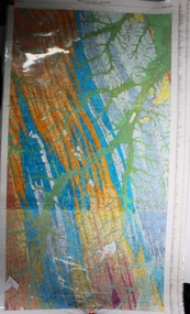
Map - Geological survey of Bendigo Goldfields
Three Geological survey maps of the Bendigo Gold Fields joined together. The three sections are Eaglehawk, Golden Square and Spring Gully. It shows geological conditions, gold reef lines and mine sights. Three sections are laminated together. The maps were produced by the Victorian Department of Manufacturing and Industry Development geological survey, bendigo gold fields -
 The Beechworth Burke Museum
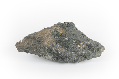
Geological specimen - Mangan Hedenbergite
This specimen was recovered from Broken Hill, NSW. It was given the name Mangan Hedenbergite in 1819 by Jöns Jakob Berzelius in honor of Mr. Anders Ludvig of Hedenberg who was the first to define hedenbergite as a mineral. Hedenbergite, belongs in the pyroxene group having a monoclinic crystal system. The mineral is extremely rarely found as a pure substance. Mangan Hedenbergite is a manganese bearing variety of Hedenbergite. Manganese is the world’s fourth most used mineral after iron, aluminium, and copper primarily because it has no satisfactory substitute in its major applications. Globally, the steel industry is the primary user of manganese metal, utilizing it as an alloy to enhance the strength and workability of steel and in the manufacture of tin cans. Manganese is a key component of certain widely used aluminium alloys and, in oxide form, dry cell batteries used in electric vehicles. These batteries are in high demand. Another potential use for manganese may as an additive to help coat and protect a car’s engine. Manganese is also used for non-metallurgical purposes such as plant fertilizers, animal feed, and colorants for bricks. This specimen is part of a larger collection of geological and mineral specimens collected from around Australia (and some parts of the world) and donated to the Burke Museum between 1868-1880. A large percentage of these specimens were collected in Victoria as part of the Geological Survey of Victoria that begun in 1852 (in response to the Gold Rush) to study and map the geology of Victoria. Collecting geological specimens was an important part of mapping and understanding the scientific makeup of the earth. Many of these specimens were sent to research and collecting organisations across Australia, including the Burke Museum, to educate and encourage further study.A hand-sized mineral specimen in shades of silver and blackmanganese, open cut mine, manganese ore processing, bell bay, tasmania, northern territory, steel industry, zinc-carbon batteries, alkaline batteries, tin cans -
 Bendigo Historical Society Inc.
Map - STRUGNALL COLLECTION: BENDIGO GOLD FIELD GEOLOGICAL SURVEY, 1936
... of Mines Victoria Bendigo Goldfieds Geological Survey. Prepared ...BHS CollectionBendigo Goldfieds Geological Survey. Prepared in the Bendigo Office Lower Section of original map. Note with map says other items donated - yet to be catalogued. TO BE FOUNDDept of Mines Victoriabendigo, gold mining, geological map -
Bendigo Historical Society Inc.
Map - STRUGNELL COLLECTION: BENDIGO GOLD FIELD GEOLOGICAL SURVEY, 1936
... of Mines Victoria Bendigo Goldfieds Geological Survey. Prepared ...BHS CollectionBendigo Goldfieds Geological Survey. Prepared in the Bendigo Office Top Section of original map.Dept of Mines Victoriabendigo, gold mining, geological map -
 Bendigo Historical Society Inc.
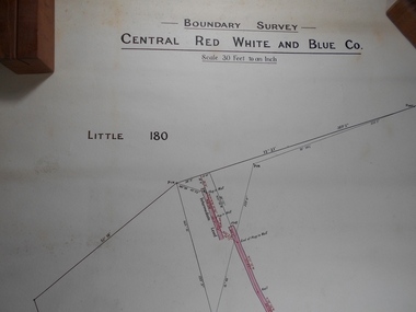
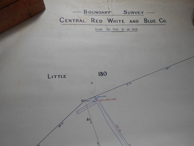
Administrative record - Central Red White and Blue
Draftsman's drawing Boundary Survey Central Red White and Blue Map Forms part of the Margaret Roberts Collection of mining records.bendigo, margaret roberts, gold, map, mine, central red white and blue -
 Bendigo Historical Society Inc.
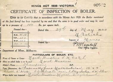
Document - MCCOLL, RANKIN AND STANISTREET COLLECTION: NORTH HUSTLERS GMC NL, 1934 - 1940
Document. Envelope contains: - Dept. of Lands and Survey Permissive Occupancy agreement & receipts, Fire Policy, Cert. of Inspection of Boiler, Insurance Policies, Crown Land Receipts. Right No. 4827 Eaglehawk. Pressure Gauge readings from Russell & Russell, manufacturer of Steam Vacuum and Compound Gauges dated 25th August 1939.McColl, Rankin & Stanistreetorganization, business, gold mine, mccoll, rankin & stanistreet, north hustlers gmc nl, gold mining, dept. of lands & survey permissive occupancy agreement, fire policy, state accident insurance mine policies -
 Bendigo Historical Society Inc.
Administrative record - South Nell Gwynne G.M. Co. N.L. Share Register, 1939 to 1941
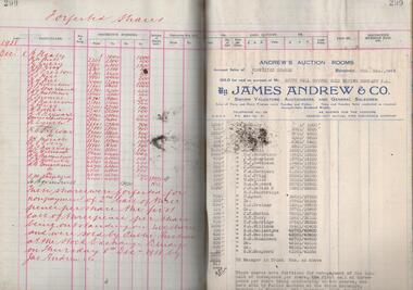
See Geological Survey Victoria: GSV Reference ID: 43711 South Nell Gwynne 'The Central Nell Gwynne which recently took over the reef prospected by Nell Gwynne ( B.M.L.) will continue to work the mine until the new Company, South Nell Gwynne Gold Mining Company is ready to take over. The main development work is at the 1080 feet level where stoping is being carried out on a spur system which has shown several colours of gold. ...The trial crushing in shaft sinking gave 4 dwt per gold per ton..... ' ( 29th July 1938, 'The Herald, Melbourne) 1941 Geological Survey Vic: SOUTH NELL GWYNNE, BENDIGO. MINING AND GEOLOGICAL JOURNAL: ' Journal, dark green hard cover, buff bindings on spine and corners. On spine of book in gold print: ' Share Register South Nell Gwynne G.M. Co. N.L.' South Nell Gwynne Gold Mining Company share register, 1938 to 1941. Alphabetical index in front, four hundred pages. Entries detail date of purchase, name of shareholder, distinctive number range, call account and paid by. Page 299 has a list of forfeited shares in the Company with a list of shares sold by James Andrew & Co., on 8th December 1938. Shares were 'forfeited for non payment of the 2nd call of threepence per share'. Share register is part of the Margaret Roberts Collection. bendigo, goldmining, goldfield, south nell gwynne gold mining co., nell gwynne, margaret roberts collection, mr j.j. stanistreet, mine manager -
 Bendigo Historical Society Inc.
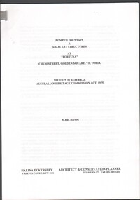
Document - Pompeii Fountain & Adjacent Structures at "Fortuna"
Fortuna Villa was initially commenced as a modest single storey home in 1861 next to the 180 Mine by Theodore Ballerstedt, who sold the mine and house to George Lansell in 1869. Lansell already owned the adjacent Fortuna Mine, and through deeper mining techniques greatly expanded the mine's operation, his personal wealth, and the house and grounds. Lansell was soon known as the 'Quartz King', Australia's first gold mining millionaire and credited as the driving force behind much of Bendigo's prosperity. He continuously added to and expanded the villa, decorating it extravagantly with the finest of artworks and materials, into a sprawling mansion with extensive landscaped grounds, to create a house and grounds of a size and grandeur with few rivals in Australia. After his death in 1907, his second wife Edith carried on with improvements, creating a house and grounds developed over 50 years. The attached mine also contributes to its significance, being one of the richest mines in Bendigo, and at one stage probably the deepest gold mine in the world at 3176 feet. The 1875 crushing works are attached directly to the mansion, and the mine's tailings and settling ponds (turned into ornamental lakes) represent a direct link between George Lansell's wealth and its source. Fortuna was compulsorily acquired by the Commonwealth in 1942 as the Cartographic Headquarters of the Australian Survey Corps during World War II, and many ancillary structures were added while preserving the main house and ornamental grounds. Victorian Heritage Database Report https://vhd.heritagecouncil.vic.gov.au/places/68334/download-reportConservation report for the Pompeii Fountain & Adjacent Structures at "Fortuna" Chum Street, Golden Square, Victoria. Prepared for Fortuna Historical Committee. March 1996.Halina Eckersley, Architect & Conservation Planner, Kewpompeii fountain, greenhouse, fortuna lake, gardens -
 Bendigo Historical Society Inc.
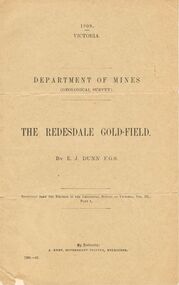
Document - MCCOLL, RANKIN AND STANISTREET COLLECTION: THE REDESDALE GOLDFIELD, 1909
... 1909 report from the Department of Mines Geological Survey... the Department of Mines Geological Survey on the Redesdale Goldfield by E ...1909 report from the Department of Mines Geological Survey on the Redesdale Goldfield by E. J. Dunn. F.G.S. Reefs mentioned are the Horseshoe Bend Reef, Linda Reef, Bill Smith's workings, the Ben Guy Reef and the Amelia ReefDepartment of Minesgold mining, miners' safety cage, redesdale goldfield, gold mining, redesdale. -
 Federation University Historical Collection
Book, William Harvey Emmons, The Principles of Economic Geology, 1940, 1940
The book was used by Charles Bacon who studied at the University of Nevada in the late 1930s/early 1940s. Bacon worked at Bunker Hill Mines and Kellogg Idaho, before arriving in Australian in 1951. He worked for CN Myers, a company involved with paper converting. CN Myers was a family business (on Charles Bacon's maternal line). William Emmons was Professor and head of Geology and Mineralogy at the University of Minnesota; Director of Minnesota geological Survey; and previously Geologist, Section of Metalliferous Deposits, United States Geological Survey.Maroon soft covered book of 529 pages. Chapters include Magmatic Segregations, Pegmatities, Hypothermal Deposits, Sedimentary Depostis, Openings in Rocks, Metasomatic Processes, Mineral Associations and more.Inside front cover "Charles Bacon 1940 Lincoln Hall Ass. University of Nevada Reno, Nevada"charles bacon, mining engineering, metallurgy, university of nevada, mackay school of mines, geology, california -
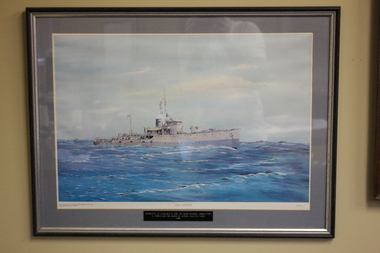 Wangaratta RSL Sub Branch
Photograph - Framed Photograph, HMAS Corvette, Unknown
The Bathurst-class corvettes were a class of general purpose vessels designed and built in Australia during World War II. Originally classified as minesweepers, but widely referred to as corvettes, the Bathurst-class vessels fulfilled a broad anti-submarine, anti-mine, and convoy escort role.The corvettes were handy and reliable, and in addition to minesweeping, patrol and escort work they were employed on an endless variety of tasks including the carrying of troops and stores, participation in bombardments and assault landings, surveying and towing operations.Brown timber frame with grey mount containing print of ship at sea HMAS Corvette Presented to Wangaratta RSL by HMAS Mildura Association in Appreciation for honour of leading ANZAC Day March 1999ww2, corvette, minesweeper, ran -
Bendigo Historical Society Inc.
Map - SECTIONS ACROSS BENDIGO GOLDFIELD
Map in three sections showing sections across Bendigo Gold Field, showing anticlines, synclines, faults, stratigraphical zones and mines along the reef lines. Key shows rock types Castlemaine, Bendigo B1, B2, B3 and B4, and Lancefieldian. First part of map shows sections A-A, B-B and C-C. Reef lines drawn with mines listed: Fault line shown are the Carshalton, Stafford, New Chum, Virginia and Clarence. A datum line shows 600 ft above sea level. On bottom of plan: ' Prepared in the Geological Survey Office, Bendigo, under the direction of H. Herman, late Director of Geological Survey, from surveys by H.S. Whitelaw, Field Geologist, assisted by E.S. Usher, A.J.J. Moore and R.A. Keble.' Second section of map shows sections D-D, and E-E. Fault lines listed are the Tambour Major fault, Carshalton fault, Stafford fault, Nell Gwynne fault, New Chum fault, Deborah fault. Third section shows sections F-F and G-G. Fault lines listed are the Bird Reef fault, Kangaroo Gully fault, Langdon fault, Carshalton fault, Nell Gwynne fault, Spring Gully fault, Hustlers fault, Gravel Hill fault, Ordes fault, Thanet fault. This map forms part of the Geological Survey of Victoria, Structure of Bendigo Goldfield report, No. 47, 1923. H.Herman, late Director of Geological Survey.Geological Survey of Victoriabendigo, gold mining, reef line maps -
Bendigo Historical Society Inc.
Map - BENDIGO GOLDFIELD VERTICAL PROJECTIONS
Map of Bendigo Gold Field in two sections showing 'vertical projections along several anticlinal axial planes showing pitch, stratigraphical zones, faultlines, shafts and etc.'. Bulletin No 47 written top left hand side. Lines of reef described: Christmas line Lancashire line Nell Gwynne line New Chum line Hustlers line Garden Gully line Sheepshead line Mines along the reef lines are listed. This map forms part of the Geological Survey of Victoria, Structure of Bendigo Goldfield report, No. 47, 1923. H.Herman, late Director of Geological Survey. On bottom of second section : Prepared in the Geological Survey Office, Bendigo, under the direction of H. Herman, late Director of Geological Survey, from surveys by H.S. Whitelaw, Field Geologist, assisted by E.S. Usher, A.J.J. Moore and R.A. Keble.Geological Survey of Victoriabendigo, gold mining, reef lines -
 Federation University Historical Collection
Document, List of Subjects
... Mechanics Mr Hart Mine Surveying Land Surveying Steam and Gas ...School of Mines Ballarat is predecessor of Federation University Foolscap sized list of Subjects from Ballarat School of Mines with handwritten names.8S3S in large writng on the back school of mines ballarat, practical chemistry, mr. walker, theoretical chemistry, theoretical agricultural chemistry, practical agricultural chemistry, technical chemistry, metallurgy, alfred mica smith, metallurgical calculations, metallurgy of gold and ore dressing, assaying practical, assaying dry, mr. murphy, ore dressing practical, mining, mining geology, mineralogy, geology, petrology, botany, applied mechanics, mr hart, mine surveying, land surveying, steam and gas engines, mr gilchrist, elementry electricity & magnetism, electrical technology, mr sutherland, turning and fitting, mr connon, engineering drawing, mr kerr, geometry, algebra, trigonometry, physics, conics, calculus, mr whitington, building construction, plane and solid geometry, plumbing grade, mr hall, mr mullins, carpentry, wool classing, materia medica, mr gutheil, technical arithmatic, mr hutchison, telegraphy, mr williams, sloyd, mr slater, photography, mr campbell, manual training, cyanide, mr deane, mr brittain, mr martell, english, astronomy, list of subjects -
 Federation University Historical Collection
Map, Ballaarat Gold Field, 1861, 1861
... map ballarat east lake wendouree survey mines robert davidson ...A party of surveyors camped by Yuille's Swamp (later Lake Wendouree) and surveyed the countryside for a map to be produced by the Geological Survey of Victoria. In November 2004 the Central Highlands Regional Library presented a special edition of 200 copies of the 1861 map reproduced from a copy in their collection. Original 1861 map of Ballarat showing streets and leads. Blue dots indicate gold leads, and red lines indicate auriferous quartz reef and outcrops of quartz veins."Compiled & Drawn from the Survey of Mining Surveyors Davidson, Fitzpatrick and Cowan & the Plans in the Surveyor General's Office by J. Brahe, 21st October 1861. R. Brough Smyth, Secretary for Mines. The Honourable J.B. Humffray, M.L.A. Commr of Mines.”ballarat, map, ballarat east, lake wendouree, survey, mines, robert davidson, ballarat gold field 1861, yuille's swamp, wendouree swamp, little bendigo diggings, gold leads, old post office hill, specimen hill, bakery hill, black hill, dead horse creek, brown hill, pennyweight hill, clayton hill, soldiers hill, golden point, gum tree flat, white flat, poverty hill, chinese village, robert brough smyth, ballarat map 1861, ballaarat vineyard, dead horse gully, deadhorse creek, invermay, black hill flat, gaelic church, police reserve, magpie range, dalton's flat, caadian lead, rifle butts, powder magazine, bathing house, government camp, gold office, chinese, llanberrris, victoria theatre, charlie napier hotel, united states hotel, grape's hoel, clayton's hill, cattleyard hill, free trade hotel, esmond lead, bakery hill, black hill lead, juvenile reformatory, ballarat orphanage, lady barkly lead, triffet's slaughter yard, little bendigo, melbourne road, t. cowan, thomas cowan -
 Bendigo Historical Society Inc.
Document - BENDIGO FOUNDRIES
... George Lansell Lansell Mine Army Survey Regiment Jorgenson's St ...Typed notes on Bendigo Foundaries. Notes mention some of the foundries that were in Bendigo, the work they did, where they were, and where some of their work can be seen.document, bendigo foundaries, horwood & sons, girton college, the victoria foundary, andrew harkness & co, palmer river diggings, george lansell, robert harkness, abraham roberts, united iron works, laanecoorie weir, bendigo railway station, coles new world supermarket, target stores, taylor horsefield's engineering works, improved harvester, hugh victor mckay, holland bros., state rivers & water supply, civic buildings, st aiden's, bendigo hospital, carter & brown, osborn bros, bendigo building society, a'becket chambers, fortuna, george lansell, lansell mine, army survey regiment, jorgenson's, st killian's fence, redpath & brown -
 Bendigo Historical Society Inc.
Document - MCCOLL, RANKIN AND STANISTREET COLLECTION: REPORT ON CASTLEMAINE, MALDON & OTHER AREAS
Copy of a typewritten report on Castlemaine, Maldon, and other areas of the main Bendigo District by H.W. Gepp Consultant on Development to the Commonwealth Government. W. Baragwanath Director of the Geological Survey of Victoria and F.L. Stillwell D.Sc. Council for Scientific and Industrial Research. Mentions Castlemaine, Fryertown, Maldon, South German Mine, Mt. Tarrengower Tunnel, Raywood, Sebastian, Wedderburn, Inglewood, Whipstick, Lightning Hill, Black Forest Mine, Old Tom Mine. Trentham. Dated 17th September 1931. Consists of 19 Foolscap PagesH.W. Gepp, W. Baragwanath, F.L. Stillwell.gold, mining, report, gold mining, bendigo, castlemaine, maldon -
Bendigo Historical Society Inc.
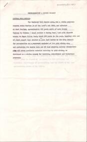
Document - VICTORIA HILL - RECOMMENDATIONS FOR VICTORIA HILL
BHS CollectionHandwritten notes on recommendations for cleaning up and signposting Victoria Hill. Also contains list of photos from the Bendigonian of 1899. List of photos: Shamrock Mine, Undershot Water Wheel at Diamond Hill for Phillips Crushing Battery. Mr Ballerstedt's Crushing Battery at Victoria Hill, Thompson's Foundry at Castlemaine, Machinery made for Bendigo Mines, Air Compressor at Shenandoah Mine, Winding Engine at Koch's Pioneer Mine, Poppet Legs at Koch's Pioneer Mine, Air Compressor at New Chum Railway Mine, Fortune Hustlers G M Co Bendigo View of Mine, Winding Plant and Afternoon Shift and Underground Work in the New Chum Railway. Also mentioned are notes on Machinery made by Thompsons. Also a carbon copy of Annual Report to Bendigo Branch Royal Historical Society, Victoria 1/7/71. Mentioned in the Report are: Historical Ball, The Central Deborah, Victoria Hill, Tours and Society Business. Albert Richardson document ?document, victoria hill, victoria hill, recommendations for victoria hill, north old chum, ballerstedt's rich 24 yard claim, floyds battery lansell's big 180, the bendigonian 26/1/1899, 2/2/1899, 20/4/1899, 11/5/1899, 10/8/1899, 14/9/1899, shamrock mine, undershot waterwheel at diamond hill, phillips crushing battery, mr ballerstedt's crushing battery, thompson's foundry, shenandoah mine, koch's pioneer mine, new chum railway mine, fortuna hustlers g m co bendigo, new chum railway, st mungo lady barkly, catherine reef, new moon, rae's open cut, old court house eaglehawk, police barracks, vic wodetzki, joss house, central deborah, central nell gwynne, mr harold curnow, bendigo branch royal historical society victoria, mrs kingerlee, felicity kingerlee, mr h biggs, city council, rotary club of bendigo south, white hills cemetry, chinese joss house, bendigo pottery, mr derham, reservoir high, princess theatre, a n a hall, mr hattam, col. sprenger, survey corps, a richardson -
 Bendigo Historical Society Inc.
Administrative record - Central Red White and Blue Mine Map
Draftsman's drawing Boundary Survey of Central Red White and Blue Co Map. Handwritten signature of Garnet G Buich, Licensed Mining Surveyor Forms part of the Margaret Roberts Collection of mining records.bendigo, margaret roberts, gold, map, mine, central red white and blue -
 Bendigo Historical Society Inc.
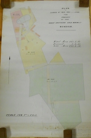
Plan - MARKS COLLECTION: LEASE PLANS GREAT SOUTHERN GOLD MINE BENDIGO
Plan on heavy paper, tightly rolled. On top of plan "Plan of Leases 5429, 4810, 4811 and 5429", The Property of the Great Southern Gold Mining Co. Bendigo' \Total area123 acres, 3 roods, 33 perches, excised, nett area 122, 0. 38. On bottom '32 feet to one inch' and 'This plan was devised from Government Mining Lease Plans and from actual survey' Signed E.F Brown, certificated mining and authorised surveyor 25/6/87' Leases No. 5429 and 4810 details location of shaft, tramway, battery, engine house and boiler. Large mining dam outlined.bendigo, mining, great southern gold mine -
 Bendigo Historical Society Inc.
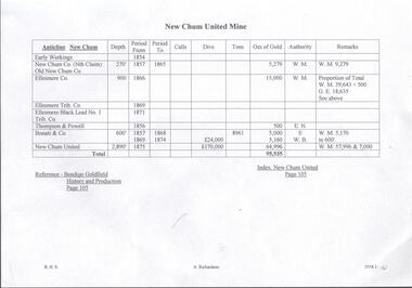
Document - NEW CHUM UNITED MINE - NOTES ON THE NEW CHUM UNITED MINE
Handwritten notes on the New Chum United Mine. Notes include: history, production, dividends, size of lease and depth of shaft. Names include: New Chum Co(Nth Claim), Old Chum Co, Ellesmere Co, Ellesmere Trib Co, Ellesmere Black Lead No 1 Trib Co,Thompson & Powell, Bonati & Co, New Chum United. Albert Richardson Collection.document, gold, new chum united mine, new chum united mine, nothes on the new chum united mine, new chum co(nth claim), old chum co, ellesmere co, ellesmere trib co, ellesmere black lead no 1 trib co, thompson & powell, bonati & co, new chum united, bendigo goldfield history and production page 105, mr clarke magee, mr h y north, mr harvey, lansell's 222, a m s 1/6/1899 page 39, lansell's big 180, wittscheibe, ballerstadt, ernst mueller, geo lansell, lansell's fortuna, a h q survey regiment's headquarters -
 Bendigo Historical Society Inc.
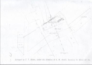
Map - LANSELL'S BIG 180 MINE - LOCALITY OF LANSELL'S NO 180 SHAFT
Buff coloured photocopy of the location of Lansell's No 180 Shaft and showing the positions of Underground Workings near the intersection of Lily St and Alley St. Also mentioned are the North Old Chum Shaft and the New Chum and Victoria Co Shaft. Luffman Brothers has been written in in pen and initialled A R. Printed at the bottom is: Surveyed by E. T. Brown, under the direction of A. W. Howitt, Secretary for Mines for the - (the rest is cut off).map, bendigo, mining plan, lansell's big 180 mine, locality of lansell's no 180 shaft, north old chum co shaft, new chum and victoria co shaft, luffman brothers, e t brown, a w howitt -
 Bacchus Marsh & District Historical Society
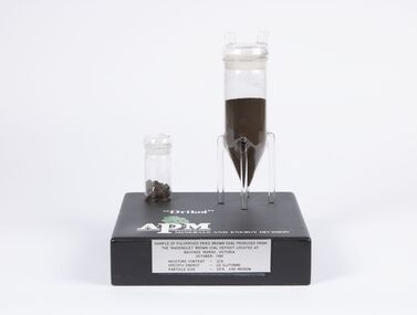
Geological specimen - Sample of Pulverised Dried Brown Coal, Maddingley Brown Coal Mine, 1981
The Maddingley area of Bacchus Marsh was surveyed for brown coal deposits in the 1930s. By the early 1940s brown coal in large quantities was being extracted and was transported to Melbourne where it was used to fire boilers for the Australian Paper Mills (APM) company. By the 1970s APM was using natural gas instead of coal. Maddingley brown coal was then used to fire boilers for the CRA/VISY cardboard factory at Bacchus Marsh. This factory closed down in 1990. During the 1990s the mine was acquired by the Calleja family company who ran transport and waste management operations.The Maddingley Brown coal mine was a major industry in Bacchus Marsh for 50 years. A sample of coal from the mine is a reminder of the importance of this local industry over an extended period of time.Two cylindrical plastic containers mounted on rectangular baseSample of pulverised brown coal produced from Maddingley brown coal deposit located at Bacchus Marsh Victoria, October 1981. Moisture content 12% - Specific energy - 22 GJ/Tonne - Particle size - 25% +90 Microncoal mines, mining, brown coal, maddingley brown coal mine -
 Stawell Historical Society Inc
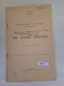
Book, E.J. Dunn, Department of Mines Geological Survey The Stawell Gold Field - Previously Cat No 3643-1, 1909
... Department of Mines Geological Survey The Stawell Gold...1909 Victoria Department of mines (Geological Survey... Survey) {in Ink} Brought at Melbourne Mines Museum, Russell St ...A short Geological analysis of the Stawell Gold FieldsFawn Paper cover with two staples along spine1909 Victoria Department of mines (Geological Survey) {in Ink} Brought at Melbourne Mines Museum, Russell St 7.3.78. Ron Wood} The Stawell Gold Field By E.J. Dunn F.G.S Replicated from the Records of the Geological Survey of Victoria, Vol III. Part 1. By Authority J. Kemp, Government Printer, Melbourne. 7290 -2stawell mining -
 Federation University Historical Collection
Map, Ballaarat Gold Field, 1861, 21/10/1861
A party of surveyors camped by Yuille's Swamp (later Lake Wendouree) and surveyed the countryside for a map to be produced by the Geological Survey of Victoria. In November 2004 the Central Highlands Regional Library presented a special edition of 200 copies of the 1861 map reproduced from a copy in their collection. Original geological map of Ballarat showing property, waterways, mines, churches, schools, water races, and garden reserves. It was compiled and drawn from the surveys of Mining Surveyors Davidson, Fitzpatrick and Cowan.Compiled & Drawn from the Survey of Mining Surveyors Davidson, Fitzpatrick and Cowan & the Plans in the Surveyor General's Office by J. Brahe, 21st October 1861. R. Brough Smyth, Secretary for Mines. The Honourable J.B. Humffray, M.L.A. Commr of Mines.ballarat, map, davidson, robert brough-smyth, fitzpatrick, cowan, yuille's swamp, public garden reserve, manure depot, black hill, ballarat east, old post office hill, pennyweight hill, claytons hill, golden point, mining, railway, cricket ground, swamp creek, cemetery, sludge reserve, bakery hill, gaelic church, juvenile reformatory, orphanage, specimen hill, eureka lead, cattle yard hill, dalton's flat, chinese village, poverty hill, railway reserve, little bendigo diggings, pound reserve, allied armies, flour mill, agricultural reserve, marsh, survey reserve, survey corps, white flat, yarrowee, yarrowee creek, brache, j. brache, survey, ballaarat gold field 1861 -
 Bendigo Historical Society Inc.
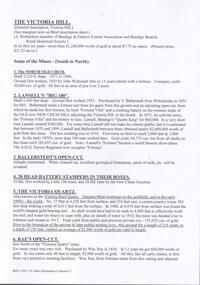
Document - THE LAZARUS MINE - NOTES ON THE THE LAZARUS MINE
One siix page handwritten and three typed copies of notes on the The Lazarus Mine including the Lazarus New Chum and the Lazarus No 1 on the New Chum Line of Reef. Notes include locality, depth of shafts, size of lease, plant, early history, the Lazarus Company, Prominence, Best Gold and Total Gold Yields. Notes prepared by Albert Richardson.document, gold, the lazarus mine, the lazarus mine, notes on the the lazarus mine, lazarus new chum, lazarus no 1, australian headquarters survey unit, george lansell, new chum hill, b c v 8 studios, sheepshead, central red white & blue, mr lazarus, lansell's 222, old chum mine, lazarus company, mr george gibbs, lansell's fortuna, ballerstedt, mr barnet lazarus, the black lead, the white lead, mount alvernia hospital, mines dept special edition 'australian mining standard' 1/6/1899, mines dept booklet 'bendigo goldfield' 1936, mines dept annual and quarterly reports, annals of bendigo mining sections 1868 - 1910, a richardson, the bendigo goldfield registry j n macartney 1/3/1871 -
 Bendigo Historical Society Inc.
Document - VICTORIA HILL - VICTORIA HILL HISTORY
Hand written notes and typed copy of the history of Victoria Hill area. Some of the mines from South to North: North Old Chum, Lansell's 'Big 180', Ballerstedt's Open - Cut, 20 Head Battery Stampers, The Victoria Quartz, Rae's Open - Cut, which has some colourful geographical features, Central Victoria (also known as the 'Midway'), Wittshiebe's 'Jeweller's Shop', Boldt's 5 Head Crushing Battery (site only), Advance Shaft, Hercules & Energetic. Notes prepared by Albert Richardson.mine, gold, victoria hill, victoria hill, victoria hill history, north old chum, john wybrandt, lansell's 'bit 180', t ballerstedt, wittschiebe, fortuna villa, geo lansell, a h q survey regiment, ballerstedt's open cut, victoria quartz (victoria reef quartz), rae's open cut, wm rae, gt central victoria (midway), adventure, wittshiebe's 'jeweller's shop', boldt's 5 head crushing battery, advance, cinderella, hercules & energetic, john brown knitwear factory, a richardson -
 Bendigo Historical Society Inc.
Document - VICTORIA HILL - RECOMMENDATION - MINING PROJECT
... Fortuna A H Q Survey Regiment Lazarus Mine B C V 8 Television ...Two (a & b) typed copy of a recommendation for mining project, accepted Nov. 1967. Recommendation for Central Nell Gwynne area, now a public purposes reserve for preservation as a permanent reminder of the gold mining era. Victoria Hill Area mentioned for it's geographical and historical significance. The New Chum Hill area rich in historical and mining. Notes on development of the Central Nell Gwynne, Victoria Hill and New or Old Chum Hill areas. Notes prepared by Albert Richardson.mine, gold, victoria hill, victoria hill, recommendation - mining project, central nell gwynne, jack barker, victoria hill area, big 180, victoria quartz, new chum hill (old chum hill), p. m. g. repeater station, mine's department, land's department, lansell, fortuna, a h q survey regiment, lazarus mine, b c v 8 television studio -
 Bendigo Historical Society Inc.
Document - VICTORIA HILL - MINES SITUATED ON VICTORIA HILL
Three pages of typed notes on creamy paper. Notes mention the mines on Victoria Hill and gives some information about them such as depth, ounces of gold extracted and who owned them. Mines mentioned are: The North Old Chum, Lansell's Big 180, Ballerstedt's Open-Cut, Little 180 Crushing Battery, the Victoria Quartz, Rae's Open-Cut, Great Central Victoria, Wittshiebe's 'Jeweller's Shop', Boldt's 5 Head Crushing Battery, Northern Slope and the Advance Shaft. Written in pencil at the top: Copy of material sent to Herald Reporter by R. Aulsbrook 30/7/68. Copied from my material and initialled AR. Notes prepared by Albert Richardson.mine, gold, victoria hill, victoria hill, mines situated on victoria hill, john wybrandt, wittscheibe, t ballerstedt, fortuna villa, george lansell, a h q survey regiment, ballerstedt's open-cut, little 180 crushing battery, little 180 mine, new chum syncline, victoria quartz (victoria reef quartz), rae's open-cut, william rae, great central victoria (midway), adventurer, wittshiebe's 'jeweller's shop', boldt's 5 head crushing battery, northern slope, the advance shaft, cinderella, hercules and energetic, john brown knitwear factory, r aulsbrook, the herald -
 Bendigo Historical Society Inc.
Document - VICTORIA HILL - SPECIAL FEATURES
... Mine A H Q Survey Regiment Tallest poppet legs Lazarus Mine ...Four hand written pages and typed copy, titled The Victoria Hill - Special Features. Notes mention the Victoria Hill, the deepest workings on the field,the first mine on the field to 2,000 and 3,000 feet in depth, Ballerstedt's Open-Cut, Rae;s Open-Cut, Wittscheibe's Jeweller's Shop, the Adventure, the richest cross-section of the whole of the Bendigo Goldfield, the first mine to pay dividends from ore mined below 1,000 feet to 1,500 feet from the surface, the tallest poppet legs on the field, Lazarus Mine, Barnet Lazarus, Mt Alvernia Hospital, Central Red White & Blue. Notes prepared by Albert Richardson.document, gold, victoria hill, victoria hill, victoria hill - special features, john neill macartney, the argus, the australasian, bendigo goldfields registry, victoria reef quartz mine, the deepest workings on the field, the first mine on the field to reach 2, 000 and 3, 000 feet in depth, lansell's 'big 180' mine, hot water, george lansell, theodore ballerstedt, fortuna, ballerstedt's open-cut, rae's open-cut, wittscheibe's jeweller's shop, adventure, advance, cinderella, the private pioneer coy, new chum & victoria mine, a h q survey regiment, tallest poppet legs, lazarus mine, barnet lazarus, mt alvernia hospital, central redwhite and blue, hudson's, burrowes & sterry, b c v 8 television station, swan hill's channel 11