Showing 404 items
matching tambo
-
 Orbost & District Historical Society
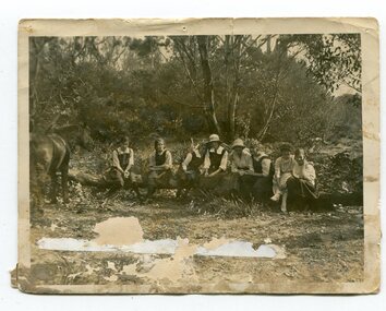
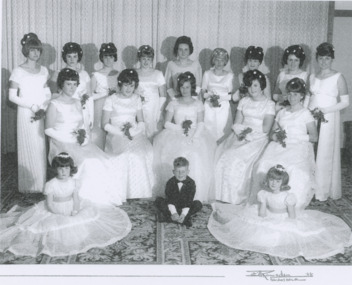
black and white photograph, 1923
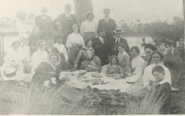
This photograph was taken at the "old station" at Corringle near Orbost. It was a popular picnic spot. Late in 1857 Mr Thomas T. Stirling took over Corringle Run ("Corringle" means "shallow water"). Mr Stirling and his family came from the wester district - Winchelsea. He settled at the Old Station. A few people were employed at the Orbost Stationb and there was settlement on the Orbost flats, Mr T. T. Stirling held the land from Lake Tyrers to Bemm River as a cattle run. About 1888 he became Secretary of the new Tambo Shire. In the photograph L-R are; Hilda Kerr; Myra Malcolm; Marion Nixon; Bess Goudie (teacher); Mary Gilbert; Gwen Hobson (teacher); Pen GilbertOrbost High School / Orbost Secondary College has played a significant part in the education of senior students in the Orbost district . It is the sole senior educational institution. This item is representative of its history. It is a useful reference tool.A black / white photograph of a group of young women sitting on a log in a clearing in a bush setting. Five are in school uniform. On the left is a horseeducation-orbost orbost-higher-elementary-school recreation old-station-corringle -
 Orbost & District Historical Society
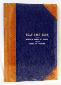
cash book, first half 20th century
This ledger was used by the Shire of Orbost to record transactions relating bto the Newmerella Drainage Area from 1927 to 1950. The item was donated to Orbost & District Historical society from P.R.O.V. as a Place of Deposit (POD) item for safe keeping by a local history group or museum. The shire covered an area of 9,347 square kilometres and existed from 1892 until 1994 when it became part of the East Gippsland Shire Council. Orbost was at first included in the Bairnsdale Shire from 1882 and was later part of the Tambo Shire. Because of travelling distances the Croajingalong Shire was created in 1892 (name changed to Orbost Shire 17.2.1893 with James Cameron as the first Shire President. In 1994 it amalgamated to become part of East Gippsland Shire Council.This item is a hand-written record of the accounts of the Orbost Shire local government. It pre-dates computer records. The Orbost Shire Council no longer exists having been absorbed into the East Gippsland Shire Council. A ledger with a black cover and brown binding. It has marbled end covers. It contains handwritten records of transactions relating to the Newmerella Drainage Area. On the front cover in gold print is "LOAN CASH BOOK (underlined) NEWMERELLA DRAINAGE AREA ACCOUNT (underlined) SHIRE OF ORBOST". on spine - "Newmerella Drainage Area Cash Book" in gold print.orbost-shire-council ledger accounts newmerella-drainage-area -
 Lakes Entrance Historical Society
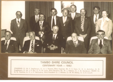
Photograph - Tambo Shire Council and staff 1982, 1982
Black and white photograph showing fourteen members of Tambo Shire Council and staff Cr. W F Stephenson, A L Parsons, Shire Engineer, Mr F S Coco, Cr. D A McArthur, Cr. D Kuglemann, W J P Rau, R W Lucas Shire Secretary,Mr W J Hobson, Cr. J M Henderson Front Cr G D Timmins, C J F McCoubrie, Shire President, J Whelan, WW McKay, G R Crouch. Also a second identical photographaccommodation, township -
 Orbost & District Historical Society
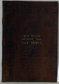
account book, BETE BOLONG DRAINAGE AREA PAY SHEET, 1910 - 1913
This account book was used by the Orbost Shire council to record payments made for work done on the Bete Bolong Drainage Area between 1910 and 1913. The item was donated to Orbost & District Historical society from P.R.O.V. as a Place of Deposit (POD) item for safe keeping by a local history group or museum. The shire covered an area of 9,347 square kilometres and existed from 1892 until 1994 when it became part of the East Gippsland Shire Council. Orbost was at first included in the Bairnsdale Shire from 1882 and was later part of the Tambo Shire. Because of travelling distances the Croajingalong Shire was created in 1892 (name changed to Orbost Shire 17.2.1893 with James Cameron as the first Shire President. In 1994 it amalgamated to become part of East Gippsland Shire Council. This item is a hand-written record of the accounts of the local government. The Orbost Shire Council no longer exists having been absorbed by the East Gippsland Shire Council.A brown leatherette, hard cover book. In gold lettering on the front is "BETE BOLONG DRAINAGE AREA PAY SHEET". It contains records of payments made for work done 1910-1913.In gold lettering on the front is "BETE BOLONG DRAINAGE AREA PAY SHEET".bete-bolong-drainage-area accounts orbost-shire -council -
 Orbost & District Historical Society
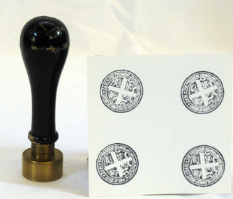
Council Seal
This item was used as a seal (stamp) on official Shire Council documents. The coat of arms of the Shire of Orbost was designed in the form of a cross in which five stars are depicted on a shield. A small crown above the cross indicates the loyalty of the president,councillors and ratepayers to the reigning monarch. The inner section of the shield contains 4 figures, a sheaf of wheat, a factory, a co and a ship - all representing the activities of agriculture, fishing,industry and dairying undertaken in the shire. Originally part of the Bairnsdale district, Orbost split away as part of the Tambo Shire in 1882, and became a shire in its own right as the Shire of Croajingolong on 30th May,1892. The name was changed to the Shire of Orbost on 17th February, 1893. The Orbost Shire Council was abolished on 2nd December, 1994 as part of a state-wide program of local government reform to become part of the newly constituted East Gippsland Shire council.Local governments play an important role in the lives of citizens in Australia. Local government authorities exist to provide services and amenities to local communities, and are also responsible for regulating and providing services for land and property in their district. This item is representative of a time when Orbost had its own Shire Council.The former Orbost Shire Council Seal (stamp) depicting the coat of arms. The circular seal is brass and has a wooden handle with a bulb shaped top.President, Councillors and Ratepayers of the Shire of Orbost-1892orbost orbost-shire-council government history seal -
 Orbost & District Historical Society
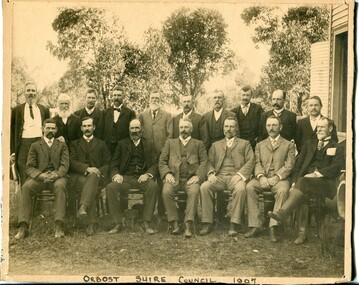
black and white photograph, Howard D. Bulmer, 1907
This photograph shows the Orbost Shire Council in 1907. In the back row are : A. Hillyard; John Draffin (sec.); David Jonson; Archie Rodwell; Hugh Cameron; Geotge Nixon; J. Hassett; Percy Watt; Wm Anderson (engineer); Wm Ross (S.R. Mail) Seated in front on chairs are : Sam Lynn; R. Pearse; John Johnston; Henry Luke (pres.); Donald Munro; Bill Cumming; Charles Grove The shire covered an area of 9,347 square kilometres and existed from 1892 until 1994 when it became part of the East Gippsland Shire Council. Orbost was at first included in the Bairnsdale Shire from 1882 and was later part of the Tambo Shire. Because of travelling distances the Croajingalong Shire was created in 1892 (name changed to Orbost Shire 17.2.1893 with James Cameron as the first Shire President. In 1994 it amalgamated to become part of East Gippsland Shire Council.This item is associated with the Orbost Shire Council. The shire covered an area of 9,347 square kilometres and existed from 1892 until 1994 when it became part of the East Gippsland Shire Council. A large black / white photograph of a group of men in two rows - front row seated; back row standing. The photograph has been taken outdoors with trees in the background and to the right a wooden building and tank. There is a copy.on front - "Orbost Shire Council - 1907" on back - "March, 1907, Shire Council"orbost-shire-council-1907 local-government -
 Orbost & District Historical Society
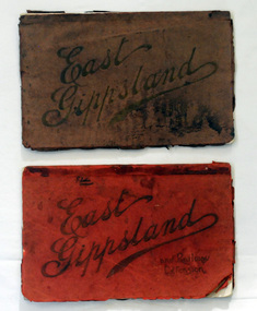
magazines, Atlas Press Pty Ltd, East Gippsland & Railway Extension, 10 September 1908
Orbost and East Gippsland Railway League had proposed a railway extension through East Gippsland in 1908, which aimed to develop an isolated part of the country. At the time, construction of a railway could be considered a beneficial investment for the country as it could increase the population in the region. The proposed railway length in 1908 was about 140 miles and the cost was estimated £800,000. The line was proposed to proceed from Bairnsdale by way of the Lower Nicholson to Bruthen. “After crossing the Tambo River, it would be carried to near Nowa Nowa; the head of Lake Tyers, forward to Orbost. From Orbost it would proceed in a north-easterly way to the New South Wales border. There were different suggested routes between Orbost and the New South Wales border, the first was through Bendoc, another by the Cann River and another which is located between these two. This item is associated with the history of the Orbost-Bairnsdale railway line and therefore reflects the role that the rail line played in the social and economic history of Orbost. The Bairnsdale-Orbost railway was opened in 1916 to serve the agricultural and timber industry. Because of the decline in traffic and heavy operating costs, the line was finally closed in August, 1987. Two small magazines showing the railway extension through East Gippsland. 678.1 has a dark maroon cover with gold print writing. It contains b/w photographs. 678.2 has a red cover with black print writing. Both are bound. 678.1 - inside front cover - M. Beattie ???????? Newmerella 678.2 - inside front cover - Gordon Fisher Orbosteast-gippsland-railway-league railway -
 Orbost & District Historical Society
ledger, 1. 8. 1915 - 30 .6. 1923
This ledger was kept by the management of a rural property in Marlo, East Gippsland. Entries were made by Hugh Cameron and Alaster Cameron. Their property was reputed to be the largest private dairy producer in Australia at one stage. (ref. Mary Gilbert) Some station owners or managers kept records like diaries, wage and ration books, and registers of births, deaths and marriages. This one records federal transactions, costs of produce and payments for share farming at Brodribb and Marl, as well as a list of donations made. Hugh Cameron (1850-1921) was on the Orbost Shire council from 1892-1915. His son Alaster was also an Orbost Shire councillor representing the East riding from 1932 to 1954. Hugh died at Orbost on 3rd May 1921, aged 71, and was buried on 5th May at the Orbost cemetery. (more info. in O.D.H.S. newsletter -Tambo Shire)This is an example of record keeping on rural properties in the first half 20th century. It is associated with the Cameron family who were early settlers in the Orbost district.A large leather bound ledger with a dark blue patterned cover and suede leatherette binding and corners. There are pages with alphabetical indexing. Some pages are ruled for accounts. All entries are hand-written in blue or black ink.There is blotting paper inside.on spine on red leatherette in gold print - " "STATION LEDGER" and on black in gold print - "CLOVERDALE"cameron-marlo dairy-farm-cameron agriculture-records station-ledger-cameron -
 Orbost & District Historical Society
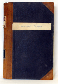
creditors' ledger, 1901 - 1960
This creditors' ledger records information about Shire purchases. The purpose of the Creditors Ledger is to provide knowledge about which suppliers the Shire has paid money to. This ledger was used by the Shire of Orbost pound keeper from 1901 -1960. The item was donated to Orbost & District Historical society from P.R.O.V. as a Place of Deposit (POD) item for safe keeping by a local history group or museum. The shire covered an area of 9,347 square kilometres and existed from 1892 until 1994 when it became part of the East Gippsland Shire Council. Orbost was at first included in the Bairnsdale Shire from 1882 and was later part of the Tambo Shire. Because of travelling distances the Croajingalong Shire was created in 1892 (name changed to Orbost Shire 17.2.1893 with James Cameron as the first Shire President. In 1994 it amalgamated to become part of East Gippsland Shire Council. This item is a hand-written record of the accounts of the Orbost Shire local government. It pre-dates computer records. The Orbost Shire council no longer exists having been absorbed by the East Gippsland Shire council.A large book with a black patterned cover with brown binding, it contains records handwritten in ink. These are records of money paid out by the local government. There are typewritten sheets of sundry creditors added to the back section of the book.hand-written on front cover on white sticker - " Creditor's Ledger" on spine in gold on red - "Ledger" ; on black - "Shire of Orbost" accounts ledger orbost-shire-council -
 Orbost & District Historical Society
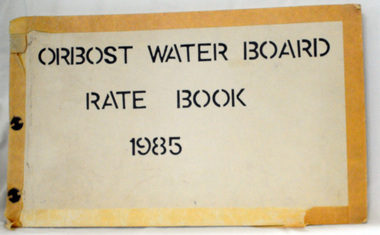
rate books, 1981 -1984
The Orbost Waterworks Trust was constituted under the Water Act 1915 and the Water Act 1916 and gazetted 10th Jan 1917. The Trust consisted of six members who were responsible for the provision of reticulated water to meet the needs of the town. The first reticulated supply to Orbost was installed about 1920. The Trust became part of the Orbost Water Board constituted under the Water and Sewerage Authorities (Restructuring Act) 1983. From 1995 the area has been served by the East Gippsland Region Water Authority. The East Gippsland Region Water Authority was constituted on January 1, 1995. The new Authority assumed responsibility for the services previously provided by the Mitchell Water Board, the Tambo Water Board, the Orbost Water Board and the Mallacoota Water Board. East Gippsland Water is the registered business name of the East Gippsland Region Water Authority. (info. from P.R.O.)These rate books are historically significant as records of an authority which no longer exists having been absorbed by the East Gippsland Water Authority,Four books which contain records of the Orbost Water Board. Each has a hand-made cardboard cover with split pins to hold the pages. The pages are carbon copies and are computer generated. 2551.1 -1981; 2551.2 - 1982 ; 2551.3 - 1983 ; 2551.4 - 1984on front covers : "ORBOST WATER BOARD RATES BOOK" with the year below. -
 Orbost & District Historical Society
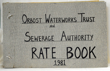
rate books, Orbost Waterworks Trust & Sewage, 1978 - 1981
The Orbost Waterworks Trust was constituted under the Water Act 1915 and the Water Act 1916 and gazetted 10th Jan 1917. The Trust consisted of six members who were responsible for the provision of reticulated water to meet the needs of the town. The first reticulated supply to Orbost was installed about 1920. The Trust became part of the Orbost Water Board constituted under the Water and Sewerage Authorities (Restructuring Act) 1983. From 1995 the area has been served by the East Gippsland Region Water Authority. The East Gippsland Region Water Authority was constituted on January 1, 1995. The new Authority assumed responsibility for the services previously provided by the Mitchell Water Board, the Tambo Water Board, the Orbost Water Board and the Mallacoota Water Board. East Gippsland Water is the registered business name of the East Gippsland Region Water Authority. (info. from P.R.O.)These accounts are historical records of an authority that no longer exists. Four rate books with hand-made covers. They are bound with string and screws. The pages are carbon copies - computer generated. 2552.1 - 1978 ; 2552.2 - 1979 ; 2552.3 - 1980 ; 2552.4 - 1981on front cover title - handwritten in black "ORBOST WATERWORKS TRUST and SEWERAGE AUTHORITY RATE BOOK" with the year below. -
 Lakes Entrance Historical Society
Photograph, 1914 c
Ema and Carrie Appleby, Will and Eva Bell, Jessie Bligh, Lena Brideson, George Bell, Carrie Froud, Phyllis Bert, Addie, Marion, May, Arthur Howlett, Fred, Marion, Alf and Gladys Legg, Jim and Mabel Thompson at a picnic on banks of Tambo River Bumberrah Victoria. Also a black and white photograph taken after marriage of Eva Howlett to William Bell on 29 February 1916 indentified are Charles, Ethel and Keith Batten, Leah, Lena Brideson, Jane Brodribb, Chaplain Carroll, Janet Duncan, Mr and Mrs Enright, Carrie Froud, Ada Grant, Mrs Healy, Herb, Marion, May, Maud Howlett, Fred, Marion and George Legg, Mr and Mrs Payne, Belle Thexton, Jim, Mabel and Edna Thompson, Mr Wilson dark copy 04411.2 , 10 x 13 cmBlack and white photograph of twenty three adults and children members and friends of the Howlett family,. Also a black and white photograph taken after marriage of Eva Howlett to William Bell on 29 February 1916 genealogy, families -
 Lakes Entrance Historical Society
Photograph - Debutant Ball, Ramsden Bairnsdale, 1966 Lakes Entrance, 1/08/1966 12:00:00 AM
Black and white photograph of debutant ball in aid of Lakes Entrance Pre School and Welfare Association. Thirteen debutants were presented to Mr Peter Nixon MHR and Mrs Nixon and Tambo Shire Pres. Cr J Kilby and Mrs Kilby Back Row Sue Davis, June Mays, Pam Long, Mavis Barling, Janis Bulls, Rhonda Newman, Faye Ostler, Kay French, Front Row Margaret Allen, Joan Allen, Marion Bryce, Kathleen Allen, Laura Mitchelson. Flower Girl and page Lynette Houston, Gary Hubbard, Linda Hancock Lakes Entrance VictoriaBill Ramsden Photographer Bairnsdalecelebration, people, debutante ball, events -
 Kew Historical Society Inc
Photograph - Bruthen to Swan Reach, 1926
Henry Beater Christian (1886-1962) , was a descendant of one of the earliest settler families in Kew. Employed at the Kew Asylum as a 'public servant', he was a skilled amateur photographer, photographing numerous scenes in Kew and on his travels around Victoria. The majority of his photographs date from 1916 to 1929. His finest photographs are housed in two photograph albums. Digital copy of a photograph from page 31 of the 47-page photograph album containing 261 gelatinous silver images, loaned by Diane Washfold with permission given to digitise and hold a copy in our collection. John Chapman has written in 'Bushwalking Clubs - A Brief History', about the establishment in Victoria of the first bushwalking club in 1888, and the popularisation of bushwalking during the interwar period. Henry Christian's 'walks' appear to have been undertaken solely or with a companion/s. This black and white photo is part of a group of six photos taken on an 18 kilometre walking trip between Bruthen and Swan Reach in East Gippsland in 1926. The route of the walk followed the Tambo River."BRUTHEN TO SWAN REACH 1926"henry beater christian (1886-1962), landscape photography, christian-washfold collection, photograph albums, bushwalking, bruthen, swan reach, tambo river, east gippsland -
 Orbost & District Historical Society
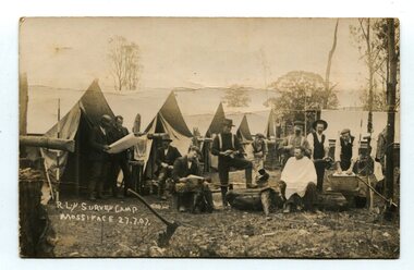
black and white photograph, July 27 1907
This is a camp of survey workers surveying the railway line . They were camped at Mossiface in 1907. It has been sent as a postcard - "Dear Miss Ross, Just a card, hoping you are well etc, trust you have not forgotten our trip. I forgot to get the name of the street in Hobart of Mr Benjamin or Temple?????? Sufficient. Yours sincerely H.R. Gordon". It has been dated September 30th 1907. There had been men surveying in East Gippsland from the late 19th century. Railway surveyors advocated two lines beyond Bairnsdale – one via Bruthen and the Tambo Valley to Omeo, the other via Swan Reach and Colquhoun to Orbost, then on to Bendoc and the border. With all the argument and feuding between the warring factions, by the end of 1891, the Parliamentary Railways Standing Committee gave up in despair of trying to reach any agreement and abandoned the idea altogether. Finally, with all problems solved, the first sod was turned at Mossiface on 9.1.1912, the government sticking to the original route in the 1890 survey .This is a pictorial record of a surveyors' camp in the early 20th century. The Bairnsdale to Orbost Railway was a significant contributor to the economy of Orbost until it closed.A black / white photograph / postcard of a group of men at a campsite. In the background is a row of tents. on the right side is a clothes line with several sheets hung over it. Two men are studying a map or chart; one man is sitting with a cloth around his shoulders while another is standing behind him cutting his hair; one man is washing cloth in a tin tub; another appears to be stirring a pot; others are sitting reading or just observing.on front - handwritten is " R.L.Y.S. SURVEY CAMP MOSSIFACE 27.7.07" on back is a letter - "Dear Miss Ross.............yours sincerely ????? Gordon"surveying-railway east-gippsland-railway mossiface-survey-camp -
 Orbost & District Historical Society
ledger, POUND KEEPERS BOOK ORBOST COUNCIL, mid 20th century
This ledger was used by the Shire of Orbost pound keeper from 15 june 1947 -12 June 1971. The item was donated to Orbost & District Historical society from P.R.O.V. as a Place of Deposit (POD) item for safe keeping by a local history group or museum. The shire covered an area of 9,347 square kilometres and existed from 1892 until 1994 when it became part of the East Gippsland Shire Council. Orbost was at first included in the Bairnsdale Shire from 1882 and was later part of the Tambo Shire. Because of travelling distances the Croajingalong Shire was created in 1892 (name changed to Orbost Shire 17.2.1893 with James Cameron as the first Shire President. In 1994 it amalgamated to become part of East Gippsland Shire Council. This book records the impounding of animals which have been found wandering on local roads or trespassing on land. Many are farm animals. Impounded animals were either claimed by their owners after payment of a fee or if unclaimed , they were sold. The Orbost Pound was situated on Martin Street.This book is a record of a practice which was necessary to remove stock which were wandering on local roads or trespassing on neighbours. It contains many local names and is of social interest. (ref. Vic. Collections)A rectangular hard cover leather bound ledger with fawn cloth spine, titled "POUND KEEPERS BOOK SHIRE OF ORBOST". Inside the back cover are several sales dockets and Shire of Orbost By-Law No 48. Pages are lined in blue and red and pages are headed in black . Entries are hand written in blue and black. The entries give particulars of the animal impounded and where found with name of council officer and owner, if known.orbost-pound orbost-shire-council -
 Orbost & District Historical Society
cash book, 1905 - 1914
This ledger was used by the Shire of Orbost pound keeper from 1906 - 1914. The item was donated to Orbost & District Historical society from P.R.O.V. as a Place of Deposit (POD) item for safe keeping by a local history group or museum. The shire covered an area of 9,347 square kilometres and existed from 1892 until 1994 when it became part of the East Gippsland Shire Council. Orbost was at first included in the Bairnsdale Shire from 1882 and was later part of the Tambo Shire. Because of travelling distances the Croajingalong Shire was created in 1892 (name changed to Orbost Shire 17.2.1893 with James Cameron as the first Shire President. In 1994 it amalgamated to become part of East Gippsland Shire Council. This book records the impounding of animals which have been found wandering on local roads or trespassing on land. Many are farm animals. Impounded animals were either claimed by their owners after payment of a fee or if unclaimed , they were sold. The Orbost Pound was situated on Martin Street.This book is a record of a practice which was necessary to remove stock which were wandering on local roads or trespassing on neighbours. It contains many local names and is of social interest. (ref. Vic. Collections)A ledger with a black cover, brown binding. The page edges are marbled. It contains hand-written records of payments received by the treasurer of the Orbost Pound.on spine : inside a red box in gold lettering"Pound Cash Book" inside a black box in gold lettering"Shire of Orbost"orbost-shire-council orbost-pound accounts cash-book -
 Kew Historical Society Inc
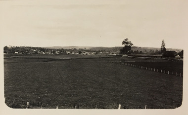
Photograph - Farmland, near Bruthen or Swan Reach, 1926
Henry Beater Christian (1886-1962) , was a descendant of one of the earliest settler families in Kew. Employed at the Kew Asylum as a 'public servant', he was a skilled amateur photographer, photographing numerous scenes in Kew and on his travels around Victoria. The majority of his photographs date from 1916 to 1929. His finest photographs are housed in two photograph albums. Digital copy of a photograph from page 31 of the 47-page photograph album containing 261 gelatinous silver images, loaned by Diane Washfold with permission given to digitise and hold a copy in our collection. John Chapman has written in 'Bushwalking Clubs - A Brief History', about the establishment in Victoria of the first bushwalking club in 1888, and the popularisation of bushwalking during the interwar period. Henry Christian's 'walks' appear to have been undertaken solely or with a companion/s. This black and white photo is part of a group of six photos taken on an 18 kilometre walking trip between Bruthen and Swan Reach in East Gippsland in 1926. The route of the walk followed the Tambo River. The photographer focusses the camera view on the township in the distance with farms in the foreground."BRUTHEN TO SWAN REACH 1926"henry beater christian (1886-1962), landscape photography, christian-washfold collection, photograph albums, bushwalking, bruthen, swan reach, tambo river, east gippsland -
 Orbost & District Historical Society
black and white photograph, 1994
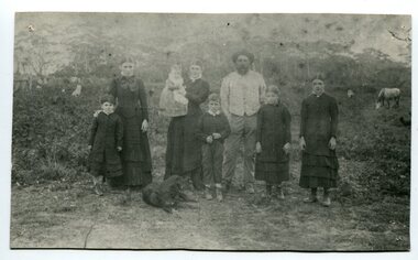
The Roadknight family settled on Ewing's Marsh on what is now known as the Old Station In 1850. The Lakes Entrance run was occupied by the late Thomas Roadknight. In 1852 his brother William took charge. Soon after this Corringle Station was occupied by the late T. T. Stirling. William was born at Collingwood, the son of William Roadknight and Jane Stirling. The Roadknight family came from Colac on board the Enterprise to their new home at Cunninghame. The house on the hill, now Pine Hill was named Merrangbaur (home of the lyrebird). William held the Lake Tyers and Snowy River run in partnership with Thomas Telfer Stirling who took up the eastern end of the run on the west bank of the Snowy River. The run included Ewing‟s Marsh — the Ewing brothers were earlier landowners but had no formal run in this area. William served four terms on the Tambo Shire Council as a representative of the Bendoc Riding despite not being a resident of the Riding. He was then elected to the Orbost Shire as a West Riding councillor in 1896-97, 1897-98 and was Shire President in his final year 1898-99 This item is associated with Roadknight family who were early settlers in the Orbost district.A black / white photograph of a family group of mother, father and six children standing outdoor. There is a dog lying in front .roadknight-william ewing's-marsh old-station-orbost -
 Orbost & District Historical Society
ledger, late 1950's - 1970's
This ledger was used by the Shire of Orbost in the late 1950's - 1970's.The item was donated to Orbost & District Historical society from P.R.O.V. as a Place of Deposit (POD) item for safe keeping by a local history group or museum. The shire covered an area of 9,347 square kilometres and existed from 1892 until 1994 when it became part of the East Gippsland Shire Council. Orbost was at first included in the Bairnsdale Shire from 1882 and was later part of the Tambo Shire. Because of travelling distances the Croajingalong Shire was created in 1892 (name changed to Orbost Shire 17.2.1893 with James Cameron as the first Shire President. In 1994 it amalgamated to become part of East Gippsland Shire Council. The Country Roads Board was the government authority for the construction and maintenance of main roads in Victoria between 1913 and 1983. It was succeeded by the Road Construction authority on 1 July 1983 and later merged with the Road Traffic Authority on July 1 1989 to form the Roads Corporation. James Cameron, an Orbost farming pioneer and Member of the Legislative Assembly, fathered the Country Roads Board This item is a hand-written record of Orbost Shire Council accounts. It pre- dates computer records. The Shire of Orbost local council no longer exists having been absorbed by the East Gippsland Shire Council.A black ledger with wooden covers. It contains hand-written records of transactions between Orbost Shire Council and the Country Roads Board.bottom left corner - Orbost in black on a white East Gippsland Shire logoledger accounts shire-of-orbost country-roads-board -
 Kew Historical Society Inc
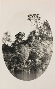
Photograph - Tambo River, 1926
Henry Beater Christian (1886-1962) , was a descendant of one of the earliest settler families in Kew. Employed at the Kew Asylum as a 'public servant', he was a skilled amateur photographer, photographing numerous scenes in Kew and on his travels around Victoria. The majority of his photographs date from 1916 to 1929. His finest photographs are housed in two photograph albums. Digital copy of a photograph from page 31 of the 47-page photograph album containing 261 gelatinous silver images, loaned by Diane Washfold with permission given to digitise and hold a copy in our collection. John Chapman has written in 'Bushwalking Clubs - A Brief History', about the establishment in Victoria of the first bushwalking club in 1888, and the popularisation of bushwalking during the interwar period. Henry Christian's 'walks' appear to have been undertaken solely or with a companion/s. This black and white photo is part of a group of six photos taken on an 18 kilometre walking trip between Bruthen and Swan Reach in East Gippsland in 1926. The route of the walk followed the Tambo River. The photographer has focussed the view using an oval frame during the development process."BRUTHEN TO SWAN REACH 1926"henry beater christian (1886-1962), landscape photography, christian-washfold collection, photograph albums, bushwalking, bruthen, swan reach, tambo river, east gippsland -
 Kew Historical Society Inc
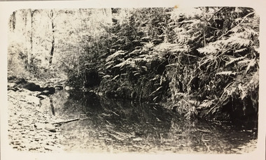
Photograph - Small creek between Bruthen and Swan Reach, 1926
Henry Beater Christian (1886-1962) , was a descendant of one of the earliest settler families in Kew. Employed at the Kew Asylum as a 'public servant', he was a skilled amateur photographer, photographing numerous scenes in Kew and on his travels around Victoria. The majority of his photographs date from 1916 to 1929. His finest photographs are housed in two photograph albums. Digital copy of a photograph from page 31 of the 47-page photograph album containing 261 gelatinous silver images, loaned by Diane Washfold with permission given to digitise and hold a copy in our collection. John Chapman has written in 'Bushwalking Clubs - A Brief History', about the establishment in Victoria of the first bushwalking club in 1888, and the popularisation of bushwalking during the interwar period. Henry Christian's 'walks' appear to have been undertaken solely or with a companion/s. This black and white photo is part of a group of six photos taken on an 18 kilometre walking trip between Bruthen and Swan Reach in East Gippsland in 1926. The route of the walk followed the Tambo River. The photographer has focussed the view on a small creek between the two towns."BRUTHEN TO SWAN REACH 1926"henry beater christian (1886-1962), landscape photography, christian-washfold collection, photograph albums, bushwalking, bruthen, swan reach, tambo river, east gippsland -
 Kew Historical Society Inc
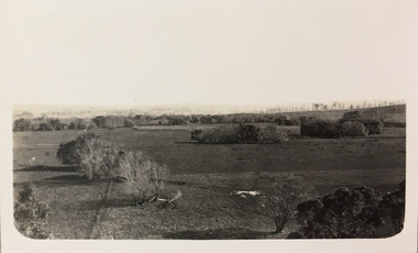
Photograph - Farmland, near or between Bruthen and Swan Reach, 1926
Henry Beater Christian (1886-1962) , was a descendant of one of the earliest settler families in Kew. Employed at the Kew Asylum as a 'public servant', he was a skilled amateur photographer, photographing numerous scenes in Kew and on his travels around Victoria. The majority of his photographs date from 1916 to 1929. His finest photographs are housed in two photograph albums. Digital copy of a photograph from page 31 of the 47-page photograph album containing 261 gelatinous silver images, loaned by Diane Washfold with permission given to digitise and hold a copy in our collection. John Chapman has written in 'Bushwalking Clubs - A Brief History', about the establishment in Victoria of the first bushwalking club in 1888, and the popularisation of bushwalking during the interwar period. Henry Christian's 'walks' appear to have been undertaken solely or with a companion/s. This black and white photo is part of a group of six photos taken on an 18 kilometre walking trip between Bruthen and Swan Reach in East Gippsland in 1926. The route of the walk followed the Tambo River. The photographer focusses the camera view on distant farmland near or between either of the two towns."BRUTHEN TO SWAN REACH 1926"henry beater christian (1886-1962), landscape photography, christian-washfold collection, photograph albums, bushwalking, bruthen, swan reach, tambo river, east gippsland -
 Orbost & District Historical Society
ledger, 1950's -1960's
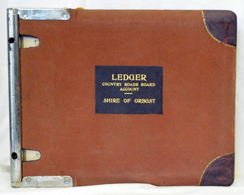
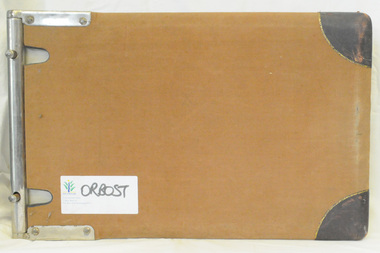
This ledger was used bt the Shire of Orbost local government to record Country Roads Board accounts 1950's and 1960's. The item was donated to Orbost & District Historical society from P.R.O.V. as a Place of Deposit (POD) item for safe keeping by a local history group or museum. The shire covered an area of 9,347 square kilometres and existed from 1892 until 1994 when it became part of the East Gippsland Shire Council. Orbost was at first included in the Bairnsdale Shire from 1882 and was later part of the Tambo Shire. Because of travelling distances the Croajingalong Shire was created in 1892 (name changed to Orbost Shire 17.2.1893 with James Cameron as the first Shire President. In 1994 it amalgamated to become part of East Gippsland Shire Council. The Country Roads Board was the government authority for the construction and maintenance of main roads in Victoria between 1913 and 1983. It was succeeded by the Road Construction authority on 1 July 1983 and later merged with the Road Traffic Authority on July 1 1989 to form the Roads Corporation. James Cameron, an Orbost farming pioneer and Member of the Legislative Assembly, fathered the Country Roads Board. This ledger is a hand-written record of accounts for the Orbost Shire local council. It pre-dates computer records. The Orbost Shire Council no longer exists having been absorbed into the East Gippsland Shire Council.A heavy brown coloured ledger with covered wooden covers. it has steel metal binding. Inside are strips of paper marking pages. It contains blue ink hand-written records of monies in/out (?) to Shire of Orbost Council. On the front cover inside a black rectangle in gold print is " LEDGER COUNTRY ROADS BOARD ACCOUNT ORBOST". It is an "Emu Binder".ledger orbost-shire accounts country-roads-board -
 Orbost & District Historical Society
ledger, 1950's ; 1960's
This ledger was used by the Shire of Orbost to record transactions with the Country Roads board in 1950's and 1960's. The item was donated to Orbost & District Historical society from P.R.O.V. as a Place of Deposit (POD) item for safe keeping by a local history group or museum. The shire covered an area of 9,347 square kilometres and existed from 1892 until 1994 when it became part of the East Gippsland Shire Council. Orbost was at first included in the Bairnsdale Shire from 1882 and was later part of the Tambo Shire. Because of travelling distances the Croajingalong Shire was created in 1892 (name changed to Orbost Shire 17.2.1893 with James Cameron as the first Shire President. In 1994 it amalgamated to become part of East Gippsland Shire Council. The Country Roads Board was the government authority for the construction and maintenance of main roads in Victoria between 1913 and 1983. It was succeeded by the Road Construction authority on 1 July 1983 and later merged with the Road Traffic Authority on July 1 1989 to form the Roads Corporation. James Cameron, an Orbost farming pioneer and Member of the Legislative Assembly, fathered the Country Roads Board. This item is a hand-written record of accounts of the Orbost Shire local Government. It pre-dates computer records,The Shire of Orbost Council no longer exists having been absorbed into th East Gippsland Shire council.A heavy brown coloured ledger with steel bindings. Covers are probably wooden. It contains hand-written records of transactions the Country Roads Board. -
 Kew Historical Society Inc
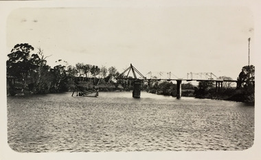
Photograph - Bridge over the Tambo River, 1926
Henry Beater Christian (1886-1962) , was a descendant of one of the earliest settler families in Kew. Employed at the Kew Asylum as a 'public servant', he was a skilled amateur photographer, photographing numerous scenes in Kew and on his travels around Victoria. The majority of his photographs date from 1916 to 1929. His finest photographs are housed in two photograph albums. Digital copy of a photograph from page 31 of the 47-page photograph album containing 261 gelatinous silver images, loaned by Diane Washfold with permission given to digitise and hold a copy in our collection. John Chapman has written in 'Bushwalking Clubs - A Brief History', about the establishment in Victoria of the first bushwalking club in 1888, and the popularisation of bushwalking during the interwar period. Henry Christian's 'walks' appear to have been undertaken solely or with a companion/s. This black and white photo is part of a group of six photos taken on an 18 kilometre walking trip between Bruthen and Swan Reach in East Gippsland in 1926. The route of the walk followed the Tambo River. The photographer has focussed the view on a ruined bridge, presumably caused by a flood, crossing the river. Sections of the left hand pier and span can be seen in the river."BRUTHEN TO SWAN REACH 1926"henry beater christian (1886-1962), landscape photography, christian-washfold collection, photograph albums, bushwalking, bruthen, swan reach, tambo river, east gippsland -
 Orbost & District Historical Society
plaque
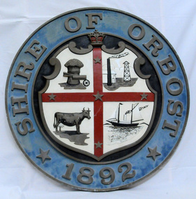
The Coat of Arms of the Shire of Orbost has been designed in the form of a cross in which five stars are set on a shield. This was typical of those used by many shires and cities throughout Victoria and the Commonwealth. A small crown above the cross indicates the loyalty of the President, Councillors and Ratepayers to the reigning King or Queen. The inner circle of the shield contains four figures, a sheaf of wheat, a factory, a cow, and a ship, which represents the activities of agriculture, fishing, industry and dairying undertaken in the district. Originally part of the Bairnsdale district, Orbost split away as part of the Shire of Tambo in 1882, and became a Shire in its own right as the Shire of Croajingolong on the 30th may 1892. The name changed to the Shire of Orbost on 17 February 1893. Orbost was divided into four ridings on 31st May 1895, they were the North, South, East and Central riding, which was represented by three elected councillors. The Shire coat of arms was on the wall on the right of the front entrance to the building and was removed from the current building when Orbost Shire Council was amalgamated into East Gippsland Shire in 1994.The current building was opened on Friday 28th February 1969 by the Premier of Victoria, The Hon. Sir Henry E. Bolte, K.C.M.G., M.P. Local governments play an important role in the lives of citizens in Australia. Local government authorities exist to provide services and amenities to local communities, and are also responsible for regulating and providing services for land and property in their district. This item is representative of a time when Orbost had its own Shire Council. A large round metal plaque with the words SHIRE OF ORBOST1892 in gold letters around a crown and shield divided into four sections to represent four industries : Shipping ; farming - maize ; dairy and mining.SHIRE OF ORBOST 1892government orbost-shire-council coat-of-arms plaque -
 Orbost & District Historical Society
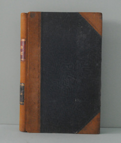
book, Key to the System of Victorian Plants, 1887 - 1888
Ferdinand von Mueller was born at Rostock, Germany, on 30 June 1825 , died at Melbourne, Australia, on 10 October 1896. He studied pharmacy and took his Doctor of Philosophy at the University of Kiel in 1847. He came to Australia in 1848 for health reasons and became a great botanical collector and writer. He was Victorian Government Botanist from 1853, and for a time Director of the Botanic Gardens. He travelled widely in Victoria and was on the A.C.Gregory expedition to northern Australia in 1855-57. He supported botanical exploration and collecting throughout the colonies. Charles Henry [Carl] Grove died on 17/4/1938 at Box Hill at the age of 88 and was buried in Orbost. Prior to coming to the Snowy River district, Carl worked as overseer on Buchan Station. In 1880, he selected land at Newmerella after first coming here in 1874 with early selector James A Robertson. He married Annie Robertson in 1876. Carl was a farmer, hop and seed grower and nurseryman. He was an elected Councillor of the newly formed Tambo Shire in 1882, and then in 1892 to the Orbost Shire where he served for many years filling varioius public roles. In 1911, he shifted to Queensland, but later returned to Victoria and died at Box Hill. (Ref. Nov 2014 Newsletter) Mueller was one of the first people to take a scientific interest in Victorian forests, and argued against indiscriminate clearing of land. This item is a useful research tool. It is associated with Carl Grove, a prominent early resident of Orbost.A black book with the title "Key To The System of Victorian Plants 1" in gold print.inside cover - "To Carl Grove from Baron Von Mueller March 1896"von-mueller-ferdinand botany-victoria plants-victoria grove-carl -
 Orbost & District Historical Society
ledger, 1906
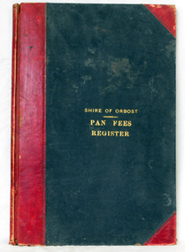
This ledger was used by the Shire of Orbost from 1906 to 1910. The item was donated to Orbost & District Historical society from P.R.O.V. as a Place of Deposit (POD) item for safe keeping by a local history group or museum. The shire covered an area of 9,347 square kilometres and existed from 1892 until 1994 when it became part of the East Gippsland Shire Council. Orbost was at first included in the Bairnsdale Shire from 1882 and was later part of the Tambo Shire. Because of travelling distances the Croajingalong Shire was created in 1892 (name changed to Orbost Shire 17.2.1893 with James Cameron as the first Shire President. In 1994 it amalgamated to become part of East Gippsland Shire Council. In Australian suburbs and rural towns where the sewer wasn't connected, people usually had an outside toilet. The toilet seat was made of a plank of wood secured at its ends to the walls of the building with a large round hole in the middle. Underneath was the removable sanitary pan and on a regular basis, usually weekly, the full pan was taken away and replaced with an empty one. This was the job of the sanitary carter. the sanitary depot was in Martins Lane, Orbost Development of the Orbost Wastewater Treatment Facility began in the 1960’s with the construction of four treatment lagoons. Shortly after the construction of the lagoons the sewerage system was installed throughout Orbost.This item is a record of accounting for the local government. The collection of sanitary pans was a necessary service before the Orbost township was had its own wastewater treatment facility.A large register of pan fees for the Shire of Orbost. A black hard cover book with red binding and marbled end pages. Entries are hand-written in black ink.On spine - "PAN FEES REGISTER: in gold lettering. In centre of front cover in gold - "SHIRE OF ORBOST (underlined) PAN FEES REGISTER"orbost-shire-council ledger-pan-fees sewage orbost-township-sanitary-service -
 Federation University Historical Collection
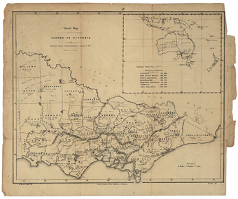
Map, Robert Brough Smyth, Sketch Map of the Colony of Victoria, c1871, c1872
This map includes the population of each County in Victoria according to the 1871 Census, as well as the population of each Australian colony and New Zealand. Telegraph Route is given in a detail at the top right. victoria, victorian counties, robert brough-smyth, telegraph, population, bourke, rodney, dalhousie, evelyn, mornington, buln-buln, tanjil, dargo, delatite, moira, bogong, bendigo, gunbower, grant, talbot, hampden, heytesbury, polwarth, ripon, kara-kara, gladstone, grenville, croajingolong, tambo, benambra