Showing 1108 items
matching timber house
-
 Eltham District Historical Society Inc
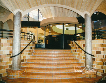
Photo album, Entrance of the new Eltham Library from the front community display space, 1994, 1994
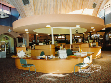
Library Development The library building has been designed to reflect its parkland setting. External features include: the roof which includes interesting aspects when viewed from Main Road; verandahs which provide ramp access and give a sheltered entrance to the building; walls which feature locally-made mudbricks, conventional bricks and copper panels; and space for an outdoor courtyard/reading area which will be developed later. Internally there are a number of features. The building includes a foyer with a fireplace suitable for displays including artwork; a community multi-purpose room suitable for meetings or functions and an outdoor cafeteria. The ceilings are lined with Victorian Ash. The shapes for the ceiling give a free flowing form to the building. Brush Box has been used for the circulation and information desks. The tree trunk columns are Grey lronbark from New South Wales. Arches and and various-shaped windows add interest to the internal structure. The carpet design reflects the Eltham environment and compliments the natural colours and timbers used in the building. Tiles by artist Felix Bosari feature in the building and additional art by local artists will be added externally and internally to the building. The library floor area is approximately 1200 sq metres and houses a collection of 50,000 items. The community multi-purpose room, foyer and community display area totals approximately 300 sq metres. These areas will be available to the community for such events a~ meetings, displays, classes, functions and art exhibitions. The Toy Library and Adult Literacy Group will also be based in the new complex. The value of works/services and fittings/ furniture is $3,040,000 Project Team Project Director: John Stamp, Director - Major Projects Project Manager: Noel Mcinnes, Noel Mcinnes Project Management Pty Ltd Architects: Gregory Burgess and Peter Ryan, Gregory Burgess Pty Ltd Site Foreman - Building Works: John Mantel Site Foreman - Site Works and Foundations: Steven White, Shire of Eltham Surveyor: Gregory Slater, Shire of Eltham Builder: Shire of ElthamPhoto album of the new Eltham Library presented to the Society by Cr R.J. Manuell, Chairperson Eltham Library Redevelopment Special Committee, 28 Nov 1994 in recognition of the efforts and contribution made by the Shire of Eltham Historical Society to the construction of the Eltham Library complex.Black faux leather album cover, black pages, brass corners and screws, 10 page inserts separated by tissue, 12 photos and information sheets stuck to pages.eltham, eltham library, panther place, shire of eltham, yarra plenty regional library -
 Eltham District Historical Society Inc
Photo album, Entrance of the new Eltham Library from the front community display space, 1994, 1994
Library Development The library building has been designed to reflect its parkland setting. External features include: the roof which includes interesting aspects when viewed from Main Road; verandahs which provide ramp access and give a sheltered entrance to the building; walls which feature locally-made mudbricks, conventional bricks and copper panels; and space for an outdoor courtyard/reading area which will be developed later. Internally there are a number of features. The building includes a foyer with a fireplace suitable for displays including artwork; a community multi-purpose room suitable for meetings or functions and an outdoor cafeteria. The ceilings are lined with Victorian Ash. The shapes for the ceiling give a free flowing form to the building. Brush Box has been used for the circulation and information desks. The tree trunk columns are Grey lronbark from New South Wales. Arches and and various-shaped windows add interest to the internal structure. The carpet design reflects the Eltham environment and compliments the natural colours and timbers used in the building. Tiles by artist Felix Bosari feature in the building and additional art by local artists will be added externally and internally to the building. The library floor area is approximately 1200 sq metres and houses a collection of 50,000 items. The community multi-purpose room, foyer and community display area totals approximately 300 sq metres. These areas will be available to the community for such events a~ meetings, displays, classes, functions and art exhibitions. The Toy Library and Adult Literacy Group will also be based in the new complex. The value of works/services and fittings/ furniture is $3,040,000 Project Team Project Director: John Stamp, Director - Major Projects Project Manager: Noel Mcinnes, Noel Mcinnes Project Management Pty Ltd Architects: Gregory Burgess and Peter Ryan, Gregory Burgess Pty Ltd Site Foreman - Building Works: John Mantel Site Foreman - Site Works and Foundations: Steven White, Shire of Eltham Surveyor: Gregory Slater, Shire of Eltham Builder: Shire of ElthamPhoto album of the new Eltham Library presented to the Society by Cr R.J. Manuell, Chairperson Eltham Library Redevelopment Special Committee, 28 Nov 1994 in recognition of the efforts and contribution made by the Shire of Eltham Historical Society to the construction of the Eltham Library complex.Black faux leather album cover, black pages, brass corners and screws, 10 page inserts separated by tissue, 12 photos and information sheets stuck to pages.eltham, eltham library, panther place, shire of eltham, yarra plenty regional library -
 Eltham District Historical Society Inc
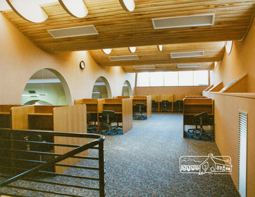
Photo album, Interior view of the new Eltham Library, 1994, 1994
Library Development The library building has been designed to reflect its parkland setting. External features include: the roof which includes interesting aspects when viewed from Main Road; verandahs which provide ramp access and give a sheltered entrance to the building; walls which feature locally-made mudbricks, conventional bricks and copper panels; and space for an outdoor courtyard/reading area which will be developed later. Internally there are a number of features. The building includes a foyer with a fireplace suitable for displays including artwork; a community multi-purpose room suitable for meetings or functions and an outdoor cafeteria. The ceilings are lined with Victorian Ash. The shapes for the ceiling give a free flowing form to the building. Brush Box has been used for the circulation and information desks. The tree trunk columns are Grey lronbark from New South Wales. Arches and and various-shaped windows add interest to the internal structure. The carpet design reflects the Eltham environment and compliments the natural colours and timbers used in the building. Tiles by artist Felix Bosari feature in the building and additional art by local artists will be added externally and internally to the building. The library floor area is approximately 1200 sq metres and houses a collection of 50,000 items. The community multi-purpose room, foyer and community display area totals approximately 300 sq metres. These areas will be available to the community for such events a~ meetings, displays, classes, functions and art exhibitions. The Toy Library and Adult Literacy Group will also be based in the new complex. The value of works/services and fittings/ furniture is $3,040,000 Project Team Project Director: John Stamp, Director - Major Projects Project Manager: Noel Mcinnes, Noel Mcinnes Project Management Pty Ltd Architects: Gregory Burgess and Peter Ryan, Gregory Burgess Pty Ltd Site Foreman - Building Works: John Mantel Site Foreman - Site Works and Foundations: Steven White, Shire of Eltham Surveyor: Gregory Slater, Shire of Eltham Builder: Shire of ElthamPhoto album of the new Eltham Library presented to the Society by Cr R.J. Manuell, Chairperson Eltham Library Redevelopment Special Committee, 28 Nov 1994 in recognition of the efforts and contribution made by the Shire of Eltham Historical Society to the construction of the Eltham Library complex.Black faux leather album cover, black pages, brass corners and screws, 10 page inserts separated by tissue, 12 photos and information sheets stuck to pages.eltham, eltham library, panther place, shire of eltham, yarra plenty regional library -
 Eltham District Historical Society Inc
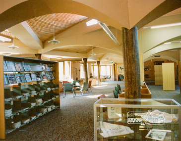
Photo album, Interior view of the new Eltham Library, 1994, 1994
Library Development The library building has been designed to reflect its parkland setting. External features include: the roof which includes interesting aspects when viewed from Main Road; verandahs which provide ramp access and give a sheltered entrance to the building; walls which feature locally-made mudbricks, conventional bricks and copper panels; and space for an outdoor courtyard/reading area which will be developed later. Internally there are a number of features. The building includes a foyer with a fireplace suitable for displays including artwork; a community multi-purpose room suitable for meetings or functions and an outdoor cafeteria. The ceilings are lined with Victorian Ash. The shapes for the ceiling give a free flowing form to the building. Brush Box has been used for the circulation and information desks. The tree trunk columns are Grey lronbark from New South Wales. Arches and and various-shaped windows add interest to the internal structure. The carpet design reflects the Eltham environment and compliments the natural colours and timbers used in the building. Tiles by artist Felix Bosari feature in the building and additional art by local artists will be added externally and internally to the building. The library floor area is approximately 1200 sq metres and houses a collection of 50,000 items. The community multi-purpose room, foyer and community display area totals approximately 300 sq metres. These areas will be available to the community for such events a~ meetings, displays, classes, functions and art exhibitions. The Toy Library and Adult Literacy Group will also be based in the new complex. The value of works/services and fittings/ furniture is $3,040,000 Project Team Project Director: John Stamp, Director - Major Projects Project Manager: Noel Mcinnes, Noel Mcinnes Project Management Pty Ltd Architects: Gregory Burgess and Peter Ryan, Gregory Burgess Pty Ltd Site Foreman - Building Works: John Mantel Site Foreman - Site Works and Foundations: Steven White, Shire of Eltham Surveyor: Gregory Slater, Shire of Eltham Builder: Shire of ElthamPhoto album of the new Eltham Library presented to the Society by Cr R.J. Manuell, Chairperson Eltham Library Redevelopment Special Committee, 28 Nov 1994 in recognition of the efforts and contribution made by the Shire of Eltham Historical Society to the construction of the Eltham Library complex.Black faux leather album cover, black pages, brass corners and screws, 10 page inserts separated by tissue, 12 photos and information sheets stuck to pages.eltham, eltham library, panther place, shire of eltham, yarra plenty regional library -
 Eltham District Historical Society Inc
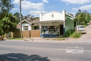
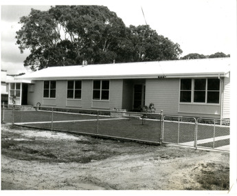
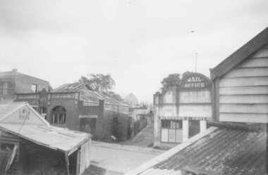
Photograph, Eltham Feed Store, cnr Main Road and York Street, c.1985, c.1985
General store and house built by C.R. Nicholl's in late 1925 at the same time J.N. Burgoyne built his store. Nicholl's sold the store and three allotments in York Street 1931. During the 1950s when the Moar family lived at No. 11 the grocery store was run by Cockcrofts. After Cockcrofts it was Davis and they turned it into a hardware store and timber yard at the side. [Note: dated based on negatives 01791 (20 Jan 1986) as service station and pricing for fuel very similar period; possibly late 1985]Reflects on the changing nature of the local street-scape and housesRoll of 35mm colour negative film, 7 stripsKodak CL 200 5093eltham, york street, main road, eltham feed store, shops, 1985, general store -
 Eltham District Historical Society Inc
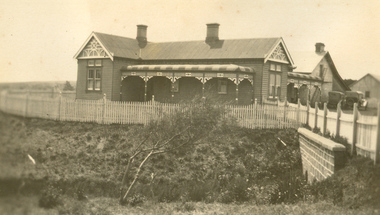
Photograph, Edendale Farm, Eltham Heritage Tour, 24 May 1992, 24/05/1992
ELTHAM HERITAGE TOUR The Society excursion on 24th May 1992 was arranged by David Bick, leader of the team carrying out the Shire's heritage study. David selected a number of sites or buildings identified in the study, some of them lesser known components of the Shire's heritage. The tour commenced at the Eltham Shire Office at 10.00 am. Travel was by private car and mini-bus with stops at about twelve locations for commentary by David. It included a short walk in Hurstbridge and lunch at Kinglake. Highlights of the tour included: - 10 am Leave from Shire Offices - 3 Important Trees - A Physical Link to Eltham's First Settlers - Toorak Mansion Gates - A Surviving Farm House - An Intact Circa 1900 Main Street - First Settlers - Gold Miners, and Timber-getters - An Early Hotel - A Pioneering Homestead - Changing Eltham Shire - 20th Century - 4 pm Afternoon Tea and Finish Tour. Extract from ELTHAM CULTURAL HERITAGE TOUR (Newsletter No. 85, July 1992, by Bettina Woodburn) "The land was unprofitable for intensive farming, but there was always water in the Diamond Creek. The railway, a technological advance, followed the valley, and was provided to transport produce. At North Eltham we were privileged to tour a surviving farmhouse of the 1860-70 era at the Shire’s Edendale Farm, with the as yet unfinished Sculpture for a front fence - bulbous tree-trunks decorated with salt pots, with cross members from the old trestle bridge. As was usual these six veranda posted houses faced South (or East, away from the sun!) with the scullery, kitchen and pantry "out the back". The veranda, which must have been very narrow, no longer exists. It probably wrapped around three sides. The drive took us past the Dutch Windmill, only twenty years old and in the Shire of Diamond Valley, then the Diamond Creek Cemetery with impressive gateway, to a detour to see another old farmhouse, isolated on a hill off Murray Road Wattle Glen. Here was a particularly thick patch of exotic planting of pines and cypresses. Subsistence farming no longer pays. Following the rail-line we noticed on the left near Silvan Road an Edwardian cottage and on the right near Yates Road the old school residence for this Upper Diamond Creek area."Colour photograph1992, culture, edendale, edendale community farm, events -
 4th/19th Prince of Wales's Light Horse Regiment Unit History Room
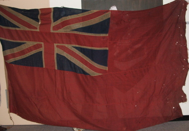
Red Ensign, Surgeons' Banner, 1850 (estimated)
Red Ensign 1801 design. - The British red ensign was altered in 1801 to include the change to the design of the Union Jack. British legislation required, with a few exceptions, that all merchant shipping throughout the British Empire fly the British Red Ensign, without any defacement or modification. The ensign is sometimes referred to as the red duster. The Royal Navy stopped using the Red Ensign in 1864. This red ensign was used by the Surgeons of the Kyneton District Mounted Rifles to indicate their location. The Banner is a large red ensign mounted on a 10 foot long polished wooden pike. The Banner was used by the Kyneton District Mounted Rifles, later The Royal Volunteer Cavalry Regiment (Prince of Wales Hussars), then Prince of Wales Victorian Light Horse, ancestor units of the modern day 4th /19th Prince of Wales’s Light Horse Regiment. In the binding is the inscription ‘Kyneton Prince of Wales Light Horse’ and three names: Surg-Major S Smith MRSLE, Dr McMillan, and Maj Thirkettle. These surgeons played a significant role in the military and civil affairs of Kyneton. Dr McMillan Dr McMillan was the first surgeon but left KPWLH 2-3 months after its formation and little else is known of him. Surgeon-Major Samuel Smith 1836 Born, Scotland 1857 Surgeon to the Hon. Hudson Bay Company. Ship “Prince Arthur” from London to Moose Fort, Hudson Bay. June 13 – Aug. 24 1857. 1858 Appointed Medical Officer of large immigrant ship to Port Phillip 1859 Appointed Assistant District Coroner, Castlemaine 1859 Appointed to Castlemaine Hospital 1862 Appointed first resident surgeon and manager of Kyneton Hospital Foundation member of Kyneton District Mounted Rifles 1874 Appointed Surgeon-Major Kyneton Volunteer Prince of Wales Light Horse Conducted a private practice in Kyneton. 1909 Died 8 November 1909, aged 73 years Samuel Smith was a Life Governor of Castlemaine Benevolent Asylum, a member of St Andrews Presbyterian Church, a Mark Master Mason of the Edward Coulson Lodge No 17, Kyneton. He also had a notable collection of stuffed native birds and animals of which he had great knowledge. Major Thirkettle 1855 Major Thirkettle arrived in Kyneton Established a timber merchant and ironmongery business in Kyneton with Robert Burton. 1857 By 1857 he was practising as an architect. His house is still standing in Yaldwin St, West Kyneton. 1860 Joined the Prince of Wales Light Horse 1863 Joined Rifle Volunteers and appointed Captain. On their disbandment he was made Honorary Major. 1864 Won Queen’s prize for rifle shooting. Major Thirkettle was noted for his skill with woodwork. He won many prizes and orders of merit for his models of yachts It is believed likely that he made the wooden pike with its metal head (now missing). He was Tyler of the Zetland Lodge, also Secretary of the MUIOOF and Bowling Club. 1904 Died in Kyneton, aged 75 years Protection for medical services The Surgeons’ Banner indicated the location of the Regimental Aid Post. The use of this device in the 1860’s overlapped the adoption of the Red Cross which became the symbol for the protection of sick and wounded soldiers. In 1864 twelve European nations signed a treaty stating that in future wars they would care for all sick and wounded military personnel, regardless of nationality. They would also recognise the neutrality of medical personnel, hospitals and ambulances identified by the emblem of a red cross on a white background. The treaty was called the Geneva Convention. This Convention was concerned only with soldiers wounded on the battlefield. Over the years, however, it has been expanded to cover everyone caught up in conflicts but not actually taking an active part in the fighting. The Surgeons’ Banner complements the Colours of the Kyneton District Mounted Rifles, also held by the Unit History Room, in presenting the colonial period of the Regiment’s history. Provenance It is believed that the Banner was manufactured in Britain and brought to Australia by Samuel Smith. After the disbanding of Colonial units, the Banner was in the care of the Shire of Kyneton until presented to the 4/19 Prince of Wales’s Light Horse Regiment on 14 September 1986 on the occasion of the Regiment exercising its right of freedom of entry to the city. There are many examples of Regimental and King’s/Queen’s Colours held by various organisations. However A Surgeons’ Banner such as this is rare, if not unique, in Australia. A large red ensign, post 1801 design. - The British red ensign was altered in 1801 to include the change to the design of the Union Jack. British legislation required, with a few exceptions, that all merchant shipping throughout the British Empire fly the British Red Ensign, without any defacement or modification. The ensign is sometimes referred to as the red duster. The Royal Navy stopped using the Red Ensign in 1864. On the binding is the inscription: "Kyneton Prince of Wales Light Horse", and three names - Surgeon Major S Smith MRSLE Dr McMillan Major Thirkettlekyneton district mounted rifles, heraldry, red ensign, surgeons banner -
 Kiewa Valley Historical Society
Photos - King Family Collection
The King family lived in Tawonga South where my older brother and sister went to school. We lived over the road from Wally Madison's farm. Later when a house became available, we moved into Valley Avenue, Mt Beauty. This is when I turned 5 and started my schooling. It was a long walk for a 5 year old as I remember. Then later we moved to 50 Lakeside Ave. I remember we loved living there as it was close to the school, footy ground and kindergarten. My father, Ted King, wad a carpenter and was involved in the building of many houses in Mt Beauty which was the home for the workers on the Kiewa Electric Scheme. So as they are part of the history of Mt Beauty I thought they may be useful to you as part of the history. The tennis photos, I vaguely remember Lou Hoad and Ken Rosewell giving exhibition matches in Mt Beauty. I may stand corrected on this, but I do remember my parents who were keen tennis players themselves were most excited at seeing these famous tennis players. As I was only 9 when we left Mt Beauty to live in Dimboola I still remember the shock of leaving a beautiful mountainous county side and arriving in a flat farming land next to a desert and seeing windmills One thing I do remember from school is, once a week (or fortnight) the teacher used to come around with a jar of little white pills, of which we were all to take. I really don't know what they were?? or for?? I also remember being taught to swim in the freezing cold river by a Mrs Smith who wore black bathers and wore her hair in a bun...... ...I am now in my 70s My father used to also carve intricate trays and jewellery boxes in his spare time. I think they were used for tennis trophies. by Diane Werner.x33 photos of small black and white photos of the Tawonga, Tawonga South and Mt Beauty - Photos not labelled but described as follows. See each photo for a possible label. A. Tawonga? B. Mt Beauty taken on the road to Bogong ? C. SEC Works D. Industrial buildings with mountains in the background E. Building site with wooden frame and 3 men F. Buildings with power poles G. Building site with lots of huts H. Buildings under construction I. Group of houses in the distance J. Group of houses in the distance K. Group of people in front of a building L. Group of 8 men sitting on timber planks, corrugated iron at back. M.& N. Building site with floor and upright timbers O. Mountain view with camp site in foreground P.& Q. Buiding site, several houses R.5 men at a building site S. portable building on trailer T & U. Mountain view V. Building site W. Group of men, car and mountains in background X. Cows Y. Pigs Z. 2 men standing next to cars. AA. Football players BB. Man painting a corrugated iron building CC. Football DD. Men in front of a building EE Buildings with mountains in background FF & GG Tennis payersHH & II. Electricity infrastructure -
 Kiewa Valley Historical Society
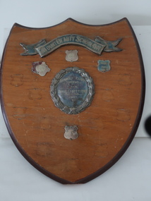
Shield - School Sports
Schools divided the children / students into houses for internal sports competition. The students' team and their participation was rewarded by acknowledgment on a shield or trophy.This trophy was for Mt Beauty Primary School sports during the 1950s and 1960s. It was sponsored by the Mt Beauty School Mothers' Club indicating that the parents supported the sports. During this time, the 1950s and 1960s Mothers' Clubs existed and supported the schools. Later they became Parents Clubs and later still struggled to exist at all as both parents went to work.Wooden shield with banner (silver plated) across the top. Central round silver plated medallion which is surrounded by 4 small medallions. Timber is stained with a darker stain around the edges. There are eyelets and wire for hanging attached to the back.The Banner: "Mount Beauty School 4644" Central Medallion: "Mothers' Club / Shield / for / House Competition / 1951" The small medallions: have house colour and year eg. "Blue / 1968"school sports, mount beauty school sports, mother clubs -
 Kiewa Valley Historical Society
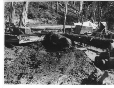
Photograph, logging at McKay Creek, Logging at McKay Creek, c1950's
This photograph was probably taken at the site of McKay Creek Power Station. Excavation of this site did not commence until 1951 but road access(a narrow track) was provided in 1948 and widened in 1954. The logs would have been milled for timber at the State Electricity Commission's mill at Howman's Gap and thus provided a much needed source of timber for construction of camps and houses as there was a general of shortage of this commodity. Because of trouble with landslides in this area, a decision was made to place the machine hall of the power station underground instead of on the surface. Restricted financial resources and the repositioning of the power station retarded construction activities and it was not completed until early 1961.. An excellent pictorial record of the general working conditions, type of machinery and vehicles in use in the 1950/s.Black and white photograph showing logging equipment, fallen logs.Handwritten on the back of the photograph "Logging at McKay Creek)logging, mckay creek, timber, machinery -
 Eltham District Historical Society Inc
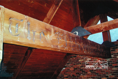
Photographs, Recycled timber beam from Eltham Barrel
... timber beam was saved and used in the construction of a house ...The iconic Eltham Barrel restaurant operated in Eltham from the late 1960s to its demise in a fire in 1989. This piece of timber - itself recycled from elsewhere (possibly the Clivedon mansion) in the construction of the Barrel had the words "Eltham Barrel" burned into the timber. It formed part of the welcome to visitors on the high external covered portico entrance. This large timber beam was saved and used in the construction of a house in Eltham.Three colour photographstimber beam, eltham barrel -
 Eltham District Historical Society Inc
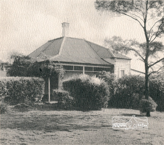
Brochure, 'Illilawa', Research
Timber Cottage circa 1881 at 35 Ingrams Road, Research.Printed Real Estate brochure of 'Illilawa', Ingrams Road, Kangaroo Ground featuring pretty stucco and timber cottage, bay windows, open fireplaces, loads of charm and character.houses, research, illilawa, ingrams road -
 Eltham District Historical Society Inc
Magazine, Sun News-Pictorial, Bush Fires: A pictorial survey of Victoria's most tragic week, January 8-15, 1939, 1939
THE WEEK REVIEWED (Article; Bush Fires: A pictorial survey of Victoria's most tragic week, January 8-15, 1939. Published in aid of the Bush Fire Relief Fund by the Sun News-Pictorial in co-operation with its newsagents, pp2-3) THE fiercest bush fires Australia has known since its discovery are quiescent at the moment, and Victoria, in the comparative coolness of the change which came with rain on Sunday night, has begun·to count its losses. In the fiery eight days, from Sunday to Sunday, at least sixty-six men, women and children have lost their lives in forest fires, or have succumbed to burns and shock; many others have died from heat; and several serious cases of burns are being treated in hospitals. Two babies in Narrandera district have died, and ten others are in hospital, because of milk soured by the record temperatures of those eight days. Forest damage totals at least a million pounds, and incalculable damage has been done to the seedlings which were to have been the forests of the future. Water conservation will be seriously affected by the silting-up of reservoirs and streams from which protective timber has been taken by the all-engulfing flames. More than a thousand houses have been destroyed, and these, with 40 mills, and schools, post-offices, churches, and other buildings, represent a loss of at least half a million. At least 1500 are homeless. For their aid, money raised in appeals has now passed the £50,000 mark, and the biggest relief organisation ever set up in peace time has swung into operation. The First Hint Victoria's first hint of what was to come appeared on Sunday, January 8, when most parts of the State awoke to find a blistering day awaiting. At 12.20 p.m., when the thermometer reached its highest for the day, 109.6 degrees, the first fire victims were at that moment going to their death on a bush track five feet wide off the main road to Narbethong. They were the forestry officers Charles Isaac Demby and John Hartley Barling, who went to warn Demby of his danger when he parted from his companions, and was himself surrounded by the treacherous fire. It was not until 8 o'clock next morning that the tragic news was flashed throughout the State. Searchers found the two charred bodies close together, one seeking protection in the nook of two logs. Barling's watch had stopped at 1.20. In the meantime, tragedy was spreading its cloak. By Monday, big fires were raging at Toolangi, Erica, Yallourn, Monbulk, Frankston, Dromana, Drouin South, Glenburn, and Blackwood, with smaller outbreaks at many other centres. In the ensuing week, while women and children were evacuated as fast as the flames would permit, Erica-scene of the 1926 fire disaster-thrice escaped doom by a change of wind. Indeed, those who have been in the fire country these past days say that the numbers of times a change of wind has saved towns from destruction is amazing. In the towns they speak of miracles. Monday's Miracles The escapes from Monett's Mill at Erica and from the Hardwood Company's Mill at Murrindindi, near where Demby and Barling went to their death, were Monday's miracles. Twenty came out alive from each mill. At the first a 60ft. dugout provided an oven-like refuge; at the second, 12 women and children survived in the smoke-filled gloom of a three-roomed cottage while their eight men, their clothes sometimes afire, poured water on the wooden walls. Three houses out of ten remained when the fire had passed. Record Temperatures Sunday had been the hottest Melbourne day for 33 years; Monday dropped to a 76.1 degree maximum; but Tuesday dawned hotter than ever, the mercury reaching 112.5. By now rumor was racing ahead of fact; whole towns were being reported lost; the alarm was raised for scores of missing persons. But fact soon overtook rumor, and within a few days the staggering toll began to mount to a figure beyond the wildest imaginings of the panic-stricken. Six died from heat on this torrid Tuesday, and the fires spread in a wide swathe from south-west to north-east across the State. Fish died in shallow streams. A curtain of smoke hid the sky from all Victoria, and hung far out to sea. It alarmed passengers on ships. On the Ormonde, on the voyage to Sydney from Burnie, women ran on deck, believing fire had broken out in the hold. Days later the smoke reached New Zealand. In Melbourne thousands of fire-volunteers were leaving in cars: vans, motor-buses-anything reliable on wheels-to aid the country in its grim fight. In the fires at Rubicon and. Narbethong, seventeen were facing death this day. But not till Wednesday, when Melbourne breathed again in a cool change, while the country still sweltered in temperatures up to 117 degrees, did the news come through the tree blocked roads. A woman and her little daughter, trapped on the road, were among those who died. Their bodies, and those of menfolk with them, were found strewn out at intervals along the road, where the furnace of the surrounding fire had dropped them in their tracks as they ran. Twelve died at a Rubicon mill, five on the road at Narbethong. At Alexandra, not far distant, a baby was born while the fires raged, and stretcher-bearers brought in the injured. On Thursday the State Government voted £5000 for the relief of fire victims. The Governor (Lord Huntingfield) and the Lord Mayor (Cr. Coles) visited some of the stricken areas, and dipped into their pockets personally. Later, the City Council, too, voted £5000. Friday, The 13th Friday, the Thirteenth, justified its evil name. A blistering northerly came early in the morning, presaging destruction, and forcing the mercury to a new record of 114 degrees. Racing fires killed at least ten in those terrible 12 hours. Four children were engulfed in the furnace at Colac. Panic drove them, uncontrollable, into the smoke-filled road when the fire raced down behind their home. They choked to death. In other parts fires were joining to make fronts of scores of miles. Kinglake was being menaced on two fronts, £60,000 worth of timber was going up in smoke in Ballarat district. Warburton was surrounded. Residents at Lorne, favoured resort, were being driven to the sea-front by a fire which destroyed at least 20 homes. Healewille. with flames visible from the town at one stage, was in a trough between two fires which burned four guest-houses, seven homes and left its surrounding beauty-spots wastes of bowed-over, blackened tree-fern fronds; with its famous Sanctuary, however, intact. Most of Omeo was destroyed this black day: Noojee. while 200 residents crouched in the river, was being reduced to a waste of buckled iron and smoking timber; Erica was once again saved by a change of wind. Beneath a pall of smoke, the Rubicon victims were buried at Alexandra. Friday night and the early hours of Saturday saw the streets of beleagured towns strewn with exhausted fire-fighters. Their flails beside them, ready for the next call, they lay where exhaustion overtook them-on footpaths, beside lamp-posts, in gutters, in cars, under trucks. Saturday's dawn brought clear skies and lower temperatures in many parts, and from the burnt-out areas came a great rush of tragic reports. The death-roll rushed past the fifty mark with incredible speed. Some had been trapped on roads, others at mills; some, after burying their treasures, had clung too long to the places they had made their homes for many years. Four men lost their lives because one went back for his dog. By Sunday, when the first of the saving rain came, nearly another score of names had been added to the list.Newspaper magazine, 48 pages (incl. covers). Fully digitised and searchable PDFPublished in aid of the Bush Fire Relief Fund by the Sun News-Pictorial in co-operation with its newsagents.bushfires, 1939 bushfires, black friday, warrandyte -
 Eltham District Historical Society Inc
Photograph, Old Bridge, Kaylock's Crossing, Brougham Street, Eltham, c.1895
Brougham Street was created in Josiah Holloway's 1851 subdivision of Little Eltham. It was one of several east-west streets shown on the subdivision plan as crossing the Diamond Creek. The western part was named Wellington Street on the subdivision plan but was later changed to conform with the name of the eastern part as acknowledgement of the continuity of the street. It is not known when the first bridge was constructed in Brougham Street however it was certainly mentioned at Council’s meeting of 2 June 1884 as being in a dangerous state of repair. This photo (c.1895) of an old bridge shows a very low-level simple log girder bridge crossing the creek at a right angle and so the approaches involved bends in the road alignment. This bridge was generally known as Kaylocks Bridge or Kaylock’s Crossing after the owner of the adjoining land. It was most likely built from around the mid-1850s, or a crossing of some fashion established as Richard George Kaylock, butcher of Little Eltham and his wife Emily Ann settled there in 1854. His property was in Wellington Street (now Brougham Street) and apparently extended across the Diamond Creek. The land on the western side of the creek was farmed, the house being on the eastern side. Kaylock's Bridge formed part of the original coach road to Eltham and in 1922 was described as an "old rustic bridge". Its low level and insubstantial construction made it susceptible to flood damage, necessitating frequent closures until repairs could be carried out. In September 1922, Council called for tenders for a new timber bridge to be constructed at Kaylock’s crossing. An engineering assessment carried out for the Council by Macleod Consulting at the time of the replacement suggested that the construction details indicate that it was in the 1900s, however this dating could possibly have been the result of numerous repairs undertaken over the years to flood damage. The tender was awarded to Mr Weller of Kangaroo Ground who commenced work in February 1923 on a higher-level timber trestle bridge. Work was slowed due to illness of the contractor and the accidental death of a man in March 1923 following the collapse of the bank after he had jumped into a hole that had just been blasted. The bridge was completed around July 1923 at which point the old structure was pulled up, marking what was described in the ‘Advertiser’ newspaper as the passing of an old and well-loved landmark in the district. In April 1924 the approach to Kaylocks bridge was washed away during the heavy flooding that destroyed the Main Road bridge. The western side was repaired, and an extra span was added to the eastern side using timber from the destroyed Main Road bridge. The bridge was again severely damaged four months later in August 1924 When a lack of finances delayed repairs to the Bridge Street bridge in 1931 (also referred to as Obelisk Bridge at the time), traffic had to detour via Brougham Street for some time. Local residents feared that the Bridge Street bridge might never reopen. Kaylocks Bridge was constantly subject to damage by floods. In the 1934 flood it was submerged by two feet of water. In more recent times the bridge was again severely damaged by flooding and repairs made. A new bridge and adjoining footbridge were constructed in 2009. Part of a slide show presentation "Bridges & Waterways of the Shire" by Russell Yeoman to the 13 September 1989 Society meeting. The presentation included slides of historic photos from the Shire of Eltham Pioneers collections as well as several recent views.Photo of earliest known crossing of the Diamond Creek at brougham StreetPostcard photo printbrougham street, eltham, wellington street, kaylocks bridge, bridge, diamond creek (creek) -
 Eltham District Historical Society Inc
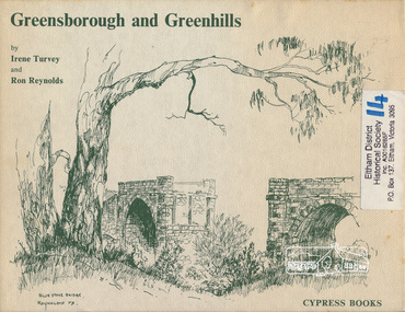
Book, Irene Turvey et al, Greensborough and Greenhills / words by Irene Turvey ; Drawings by Ron Reynolds, 1973
Pen and ink sketches accompanied by appropriate text in double page spreads. Contents cover : Blue stone bridge, Introduction, House cnr Church and Hailes Street, House - 25 Hailes Street, Yandell Reserve, Greensborough Hotel, Lobb's Kiosk, House - 49 Grimshaw Street, View of Greensborough (from Delphin Crescent), Railway Station, Old Barn (near Greensborough Railway Station), Partington's Flat and River Valley, Rand Street Bridge, Lower Main Street, Greenbriar Nursery, Hitching rail, Ashmead - Dr Cordner's Home, Greensborough Primary School, House - cnr St Helena and Diamond Creek Raods, Sondermeyer's Hill, Methodist Church, Football Pavilion, Cemetery, St Katherine's Church, St. Helena, Civic Centre, Briar Hill Timber Mill, 24 River Street, Kelly's Garden Supplies, 158 Main Street, Old Swimming pool, 105 Main Street.Hardback; 62 p. : ill., map ; 19 x 25 cm.ISBN 0909807108 Signed by author and illustrator Two copiesgreenhills, greensborough -
 Eltham District Historical Society Inc
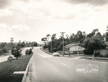
Photograph, Main Road, Eltham
Black and white photograph, looking from near Bridge street with D. Lyons house on right and the old Shire offices on the left in the distance.a.r warren, timber yard, bridge street, d lyons, houses, buildings, shire of eltham -
 Victoria Police Museum
Police Stations (Apsley)
Apsley is a small town in Victoria, Australia. It is on the Wimmera Highway, in the Shire of West Wimmera, 420 kilometres north-west of Melbourne, and 7 kilometres east of the South Australian border. Apsley Police Station opened on 29th November 1884 and was originally located in Wallace Street. It was staffed by one Foot Constable (motor cycle). The building was described, in 1930, as a four-roomed dwelling with an iron roof, set on a quarter of an acre of land. There was a bathroom, a WC, wash-house and a garage. An office adjoined the house and there was also a lockup. The station moved several times until the mid 1960s when a timber residence was moved onto land adjacent to the Post Office. The building is believed to have been transported from the Stawell area. Apsley is one of a handful of one-man police stations in Victoria and its current location, including residence, is at 19 Splatt Street. Apsley was in the Western District when it opened, then in "L" (Wimmera) District from January 1948 and "M" (Highlands/Wimmera) District from March 1990. 4 black & white photos, 1965 3 colour photos, 1987police stations; apsley police station -
 Warrnambool and District Historical Society Inc.
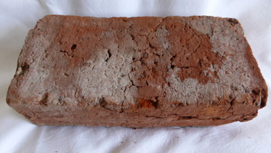
Functional object - Brick, 94 Merri Street Warrnambool, Circa 1850
The building at 94 Merri St is amongst the earliest buildings in Warrnambool. It was possibly constructed before 1854 and maybe as early as 1848. The original building consisted of four main rooms under a hip roof. The outer walls were masonry , apparently rubble The Heritage Council indcate that on the balance of probabilities this was the general store of Richard Osbourne and John Moffat Chisholm built in 1847-48.The building at 94 Merri Street had historical and architectural significance to the state of Victoria. It was a rare example of surviving, pre separation building with associated interest in its materials and components It is associated with Richard Osbourne who founded the Warrnambool Examiner(1851_1889) and the town’s first historian. Architecturally, the significance of the house lay in the hand -wrought timber framing. All the major timbers in this building had been hand sawn. The Gold rush of the 1850’s saw this process mechanised. A kitchen fireplace in the rear skillion included a large block of Merri Creek Mudstone, a combination of “tufa” and clay that was used in the Warrnambool District as an excellent substitute for fire bricks. The house was demolished in 2011 and items of significance were salvaged, this brick being one. While some bricks were imported, there is evidence that there were a number of brick burning businesses in operation around this time. However it is difficult to ascertain to which group this brick belongs. Red clay rectangular brick. Contains some small gravel like material, possibly ferrous buckshot, grey mortar remnants on side and diagonal crack along one side.warrnambool, 94 merri street, richard osbourne, john moffat chisholm, hand sawn timber, brick, building materials -
 Ringwood and District Historical Society
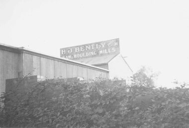
Photograph, H.J. BentleysTimber Yard and Boiler House Demolition, Ringwood 1959. (4 views)
Written next to photographs: SS0180a: "Timber racks in B. Timber yard. Now demolished. 1959. Taken from Matlocks Stables." SS0180b: "Boiler house and workshop being pulled down." SS0180c: "Bentleys from Warrandyte Rd. Pipes etc. in backyard of Bissetts shop, corner Main Street." SS0180d: "Further snap of boiler house being demolished." -
 Orbost & District Historical Society
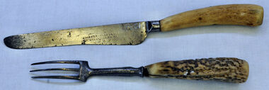
knife and fork, Joseph Rodgers & Son
The Tabbara Sawmill was located at Brodribb River, at the lower Snowy River estuary. In the early 1900’s bow saws and broad axes were used to selectively log the forest. Ox driven carts pulled the logs to the Snowy River; the logs were floated downstream to the steam powered mill. The PS Curlip steamboat, transported the timber to growing townships, for schools, houses and farms. The mill closed in 1903. Knife and fork with steel blades and bone handles..Knife - Joseph Rodgers & Son Cuttlers to her Majestyknife fork cutlery domestic-item rodgers-joseph -
 Orbost & District Historical Society
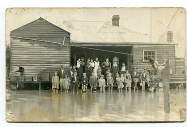
black and white photograph, poss. 1920
In the photograph are the Rice family, Billy Nixon' family and Charlie Johnston. William Nixon, son of James Nixon and Alice (Roberts) Nixon was married to Ilma Muriel (Cadwallader) Nixon on 2 Apr 1902 in Orbost. They had six children - Llewella Adele (Nixon) King, Sydney William Columbo Nixon, Arthur Harry Nixon, Jack Warton Nixon, Claudine Frances (Nixon) Taylor and Daphne Joyce (Nixon) Menz Damage estimated at £500,000 was caused by the 1934 floods in the Orbost district. This 1934 flood was devastating, destroying a section of the 1922 Orbost bridge, wrecking fences, bridges and roads, dumping silt and debris on the rich river flats and drowning cattle. Note: although this card has the date 1934 written onto the rear, the flood incident depicted most likely dates from 1920 (ref. Weekly Times, Saturday 6 March 1920 p 41 when this photo was printed).This item is a pictorial record of a flood in 1920 (ref. Weekly Times, Saturday 6 March 1920 p41). Snowy River flood are a feature of the Orbost area. These floods cover the rich agricultural land. A black / white photograph / postcard of a group of people standing in floodwaters outside a timber building. Included are young children and babies being held by women. Two boys are holding dogs in front of them.on back - "Billy Nixon's house (now Downys 1991)"orbost - floods - nixon - 1920 -
 Ringwood and District Historical Society
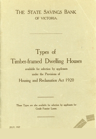
Booklet, Types of Timber Framed Dwelling Houses, Victoria, 1927
... Road Ringwood North melbourne Plans show how the modern house ...Plans show how the modern house has progressed and evolved since 1920.Grey covered booklet of plans for 53 dwelling houses available for selection by applicants under the Housing and Reclamation Act 1920. Published by the State Saving Bank of Victoria -
 Ringwood and District Historical Society
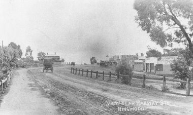
Photograph, Maroondah Highway Central, Ringwood. Main Street looking west from Warrandyte Road- 1908
Black and white photograph (2 copies)Written in lower right corner of photograph, "View near Railway Stn. Ringwood". Typed below one photograph: "Maroondah Hwy looking towards city with Warrandyte Rd coming in from right. Old Station Master's residence on left. Road had two levels here." Bank is E.S. & A. Agency. Bamford's Timber on right. Station Masters house on left. -
 Ringwood and District Historical Society
Photograph, Former Ringwood Mail office, Adelaide Street, 1955 looking along laneway to west showing Ham's Billiard Saloon to left, 1955
This laneway which ran between Bamford's Timber Yard on the corner of Warrandyte Rd and Maroondah Hwy became Civic Place. Two storey building is Renong Chambers. Bottom left shows Jack Orr's clothes hoists. Bottom right is Horman & Woolhouse plumbers. This area was demolished in 1965.Typed below photograph, "Former Ringwood Mail office, Adelaide Street, 1955". Catalogue card reads, "Adelaide St. looking along laneway to west showing former "Mail" office and Billiards Pool to left, 1955." Written on backing sheet of one copy, "Lane between Bamford's Timber Yard, corner Warrandyte Rd. and Maroondah Highway. House demolished 1965. 'Ringwood Mail' office at end of lane in Adelaide St." Another copy's backing sheet reads, "Mail Office. Lane went to Melbourne St. Ham's Billiard Saloon, Renong Chambers (2 storey) bot. left Jack Orr's clothes hoists. Bot. right Horman & Woolhouse plumbers." Another copy reads, "This laneway became Civic Place." -
 Cheese World Museum
Photograph, Tooram Park homestead c1915, early 20th century
The Percy Uebergang family lived at Tooram Park, Allansford from 1912 until 1992. Percy and Myrtle Uebergang's children were twins, Ray and Joyce born in 1926 who lived at Tooram Park until their deaths, Ray in 1986 and Joyce in 1992. Neither Ray nor Joyce married and following the death of her brother Joyce set up the Ray and Joyce Uebergang Foundation which supports the local community. This photograph is part of the collection of items given into the care of the Cheese World Museum. The Uebergang family purchased Tooram Park in 1912. It was part of the original Tooram run which was taken up in 1839/40 by John McMahon Allan. Allan held the property until 1860 after which it passed through several owners including John Orlebar, Thomas McLeod Palmer, Owen family. Tooram was famous for the cheese from its large dairy herd. The herd was hand-milked. Palmer employed Indian labour to undertake this task. In 1883 Palmer was charged with the manslaughter of an Indian worker but was acquitted. This case was extensively reported in the Warrnambool Standard. The Standard also featured a number of articles about Tooram [22 June 1882, 17 March 1883 to 15 May 1993, 30 October 1886, 22 October 1897, 11 May 1926, 8 June 1931]. The property remained in the Uebergang family until after Joyce's death in 1992. Tooram is significant as it was one of the earliest runs taken up in the Warrnambool area. It was divided up following its sale in 1897. Tooram cheese was renowned. This photograph is significant as it shows Tooram Park homestead in its earlier days with the prolific timber decoration which was later removed.Black & white photograph on a cardboard mount showing Tooram Park homestead. The house has a white picket fence. A drain is in the foreground and is serviced by a stone culvert is in the right foreground. Two cars are parked in front of the house. The house walls are painted a dark colour. The verandah roof is striped dark and white. The timber decoration on the verandah, barge board and gable is white.allansford, tooram, tooram park, uebergang, john orlebar, john mcmahon allan, thomas mcleod palmer, owen family, indian labour, court cases, dairying, dairying, warrnambool standard -
 Flagstaff Hill Maritime Museum and Village
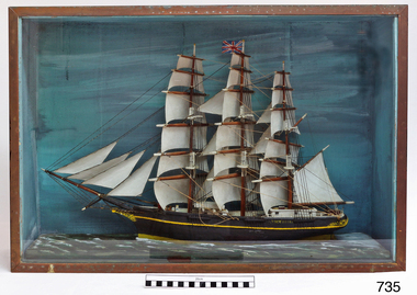
Craft - Ship Model, Victoria
Ship model, Victoria with full ship rig. 3 masted, with 2 deck houses, 2 boats on top of forward house. Yellow hull decoration. Mounted in case with painted backdrop and ocean. Timber case painted black, glass face and brass trim. flagstaff hill, warrnambool, shipwrecked-coast, flagstaff-hill, flagstaff-hill-maritime-museum, maritime-museum, shipwreck-coast, flagstaff-hill-maritime-village, ship model -
 Marysville & District Historical Society
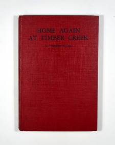
Book, Mavis Thorpe Clark, Home Again at Timber Creek, 1950
A sequel to 'The Twins at Timber Creek'. Adventures in the Australia countryside for children 7 to 11.No dust cover. Book is red with the title and the author's name in black on the front cover and spine.fictionA sequel to 'The Twins at Timber Creek'. Adventures in the Australia countryside for children 7 to 11.australia, country life, fiction, mavis thorpe clark -
 Flagstaff Hill Maritime Museum and Village
Photograph - Coastal Scene, Joseph Jordan Photographic Studio, Lady Bay and Breakwater, Warrnambool, circa 1907
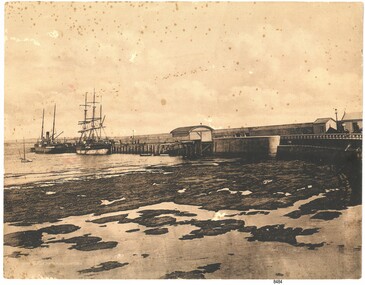
The Port of Warrnambool - In the early years the Port of Warrnambool was a busy port. Steamships and sailing ships were frequent visitors to the port. Steam navigation companies were plentiful, carrying passengers and freighting cargo such as coal, timber, food, livestock, furniture, hardware and haberdashery between Melbourne and the ports along the southwest coast of Victoria, including Warrnambool. The carts would take their loads into the township for distribution. The Breakwater was built (using 32 ton blocks of concrete) between 1874 and 1890 to provide ships with greater protection from the Southern Ocean. The Lifeboat and Rocket House - The coastline of South West Victoria has had over 600 shipwrecks and many lost lives; even in Warrnambool’s Lady Bay there were around 16 known shipwrecks between 1850 and 1905, with eight lives lost. In 1859 the first Government-built lifeboat arrived at Warrnambool Harbour and a shed was soon built to house it, followed in 1864 by a rocket house to safely store the Rocket Rescue equipment. In 1878 the buildings were moved to the Breakwater area, and in 1910 the new Lifeboat Warrnambool arrived with its ‘self-righting’ design. For almost one hundred years the lifeboat and rocket crews, mostly local volunteers, trained regularly to maintain and improve their skills, summoned when needed by alarms, gunshots, ringing bells and foghorns. Some became local heroes but all served an important role. By the end of the 1950s the lifeboat and rescue equipment had become obsolete. Joseph Jordan - Joseph Jordan was born in 1841 in Leicester England. When he was 16 he joined the 7th Queen's Own Hussars and was sent to India at the outbreak of the mutiny. He took part in the relief of Lucknow and remained in India for eleven years. It was during this time, he became interested in photography. He was posted to New Zealand and later came to Victoria, becoming a sergeant major of the Mounted Rifles. In the mid 1880s he came to the Western district where he was responsible for establishing units of the Mounted Rifles in various country towns such as Dunkeld, Mortlake, Panmure, Bushfield, Koroit etc. He resigned from the army in 1889 and set up a professional photography studio in Liebig Street, Warrnambool. He became very well known in the Western District for family photographs, official photographs of local councillors and groups as well as views of local scenery. In 1891 he photographed the wrecked barque "Fiji" at "Wrecks Beach" near Princetown. His business was taken over by his son Arthur around 1917. Joseph was a keen rifle shot and in 1924 he donated the "Jordan Shield" as a prize to the Victorian Rifle Association. He was made a "Life Honorary Member" of the Warrnambool Returned Soldiers League and in 1933 he was recognised as being the oldest living soldier in Victoria. Joseph died in 1935 aged 95.This photograph is significant for its association with the Port of Warrnambool and the Warrnambool Breakwater as it shows a point in time when shipping activities were an important part of Warrnambool's commerce and social development. It is also a record of the Warrnambool Lifeboat and Rocket house which was important in aiding ordinary citizens, harbour employees and the volunteer boat and rescue crew in saving the lives of sailors and passengers due to the high number of shipwrecks that occurred along the coastline. Joseph Jordan is a significant figure in Warrnambool history as he helped to establish early units of the Mounted Rifles (G Company) in local towns during the late 1880's and later, photographed local scenes, groups and citizens of early Warrnambool. Sepia photograph showing the beach and the Breakwater in Lady Bay Warrnambool, two ships (a steamship and a barque), a small sailboat, and the Lifeboat and Rocket House plus two smaller sheds.Front of photo - BREAKWATER, WARRNAMBOOL, VICTORIA Back of photo - "From: P Gregory / 365 Beach Road / BLACK ROCK 3193"flagstaff hill, flagstaff hill maritime museum, warrnambool, warrnambool harbour, port of warrnambool, tramway jetty, breakwater, lifeboat and rocket shed, steamship, barque, photograph of lady bay, rocket house, shipping, joseph jordan, lady bay, views of warrnambool, jordan photography -
 Federation University Historical Collection
Document - Document - Letterheads, ZILLES COLLECTION: Letterheads of various Companies - Australia
Zilles Printers was begun by Lewis Zilles in the early 1930s. It was in McKenzie Street Ballarat. His son Jeffrey also became a printer - letterpress, offset and screen printer. The business became Zilles Printers/Graphics and was in Armstrong Street and later Bell Street Ballarat. Letter and Invoice items are for various companies in Australia. The addresses on these papers have no postcodes. This indicates that they are before 1967, the year that they were introduced. .1 Touzeau Batteries Pty Ltd - 522 Little Collins Street, Melbourne. Distributors of Magnalite Batteries .2 R Tunbridge & Sons Pty Ltd - Sturt and Armstrong Streets, Ballarat. Complete House Furnishers. .3 Arlette Modes - 202b Sturt Street, Ballarat - Women's Fashions .4 William L Whitechurch - 770 Logan Road, Holland Park, Brisbane. Chemist & Druggist Supplies .5 Ballarat Timber Co. Pty Ltd - 118 Creswick Road, Ballarat. .6 A F Crotty - 8 Tichbourne Place, South Melbourne. Electroplater. Pages of various sizes, colour and inks. .5 and .6 are InvoicesNames, addresses and phone numbers of companieszilles printers, letterheads, pre postcodes, touzeau batteries, r tunbridge &sons, arlette modes, william whitechurch, ballarat timber, chemist and druggist supplies, a crotty, electroplater, melbourne, ballarat, brisbane, south melbourne, letter paper, invoices