Showing 11987 items
matching victoria road
-
 Bendigo Historical Society Inc.
Book - THE DIARIES OF RICHARD POPE, 1889
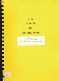
... by John F.H. Westley & 39 Craig Road, Donvale, Victoria, 11th... - 15th. October 1889' Edited by John F.H. Westley & 39 Craig Road ...The Diaries of Richard Pope - Volume VII - Bendigo and Broken Hill, 11th. January 1886 - 15th. October 1889' Edited by John F.H. Westley & 39 Craig Road, Donvale, Victoria, 11th. June 1983. ( sic )Richard Popebendigo, history, diaries of richard pope, bendigo, broken hill, goldfields, richard pope, mining -
 Federation University Historical Collection
Document, Ken Clements, Peterborough Puzzles, 2009, 2009
... Massacre Bay is located on Victoria's Great Ocean Road... Massacre Bay is located on Victoria's Great Ocean Road ...Massacre Bay is located on Victoria's Great Ocean Road, and is in the centre of the Bay of Martyrs. The bay consists of 20 m high, red limestone bluffs. This paper by Ken Clements considers the origin of the term martyr in connection to this location, and where the Aboriginal massacre may have taken place. Thirteen page document by Ken Clements relating to Peterborough, Victoria. Contents include coastal features, local Aborigines, Bay of Martyrs, Massacre Bay, Massacre Hill, Buckley Creek Run, Pioneer Pastoralists, British Traversers, settlers, Peterborough, Maps, tourism, history method. Photographs by Laurie Moore.aborigines, bay of martyrs, massacre bay, massacre hill, buckley creek run, pioneer pastoralists, british traversers, settlers, peterborough, maps, tourism, history method, childers cove, barque children, murnane bay, sandy bay, dog trap bay, buckley creek, viviennes lookeout, stanhope bay, buttres bay, burnies beach, armstrong creek, flaxman hill, antares rock, lovers nook, crofts bay, clements, worm bay, halladale point, the well, wold dog cove, james irvine monument, curdies inlet, squirrel creek, wallaby creek, boggy creek, whiskey creek, pioneer beach, schomberg rock, young australia, spit, crown of thorns, newfield bay, the grotto, london bridge, point hesse, high cliffs, the arch, cape martyr, little massacre bay, aboriginal massacre, ken clements -
 Bendigo Historical Society Inc.
Book - THE DIARIES OF RICHARD POPE, 1892
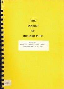
... by John F.H. Westly, 39 Craig Road, Donvale. Victoria & Panguna... Road, Donvale. Victoria & Panguna , Bougainville, PNG. Book ...The Diaries of Richard Pope, Volume VIII, Broken Hill, Bendigo, Kadina, Moonta, 16 October 1889 - 20 July 1892' Edited by John F.H. Westly, 39 Craig Road, Donvale. Victoria & Panguna , Bougainville, PNG.Richard Popebendigo, history, diaries of richard pope, bendigo, broken hill, kadina, moonta.goldfields, mining, richard pope -
 Greensborough Historical Society
Folder, Greensborough District Roads Board, 1847o
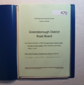
... Contents: The open road in Victoria [excerpt] by R H Croll... Plenty Lower Plenty melbourne Contents: The open road in Victoria ...Contents: The open road in Victoria [excerpt] by R H Croll; Newspaper articles on early road proposals in Greensborough area; Newspaper article from The Argus on Embezzelment of monies from Roads Board.20-page plastic binder, blue cover. Contains documents relating to the Greensborough District Roads Board.greensborough district roads board, robert henderson croll, charles buck -
 Federation University Historical Collection
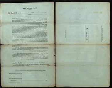
Document, A.J. Peacock, Agreement under the Mines Act 1890, 13/02/1919
... of 66 Lewisham Road Windsor, Victoria. A seal has been attached... Road Windsor, Victoria. A seal has been attached to the two ...Richard Squire was a graduate of the Ballarat School of Mines. He worked a number of mines in Victoria..1) Large legal document under the Miners Act 1890 Part 2, between Allan A. Fraser of Meredith and Richard Brereton Squire of 66 Lewisham Road Windsor, Victoria. A seal has been attached to the two signatures. .2) blank formSigned by Allan A. Fraser and Richard B. Squire. Both signatures witnessed by Annie Marchment.mining, mines act, mines act 1890, squire, richard squire, fraser, marchment, annie marchment, meredith, windsor, grenville, lalalute -
 Tatura Irrigation & Wartime Camps Museum
Photograph, Arthur Knee, Memorial to Kormoran Komeraden, 1989
... Camp 13, Camp Road, Murchison, Victoria. Memorial to fallen... Komeraden Camp 13, Camp Road, Murchison, Victoria. Memorial ...Camp 13, German compound. Memorial erected by German POW's to honour their comrades on the German Raider "Kormoran" which sank HMAS Sydney in the Indian ocean before going down, too.Camp 13, Camp Road, Murchison, Victoria. Memorial to fallen comrades, German compound. Concrete with local stone. German inscription on rectangular recessed area to "Kormoran" crew. Note. concrete machine gun emplacement (background), Eucalyptus bush distant background.camp 13, german pow's, kormoran, hmas sydney, memorial, german raider kormoran, german memorial, kormoran memorial, kormoran komeraden -
 Bendigo Historical Society Inc.
Document - ROYAL HISTORICAL SOCIETY OF VICTORIA - MEETING MINUTES - 16/02/1985, 16 Feb 1985
... Society of Victoria, 1 City Road, South Melbourne. Apologies... of Victoria, 1 City Road, South Melbourne. Apologies recorded from ...Document. Four page copy of the minutes of the quarterly meeting of the State Committee of Member Societies. Meeting held on 16 Feb. 1985 at the headquarters of the Royal Historical Society of Victoria, 1 City Road, South Melbourne. Apologies recorded from Miss F Kingerlee of the Bendigo Branch. On top left of front page handwritten in red biro 'Alec H Stone'.Mr J Irving (Gippsland) Chairmandocument, royal historical society of victoria, meeting minutes, miss f kingerlee, alec h stone. -
 Orbost & District Historical Society
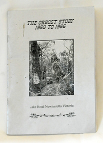
book, Johnson, Brenda, The Orbost Story 1959 to 1966, after 2000
... "The Orbost Story 1959 to 1966 Lake Road Newmerella Victoria... Lake Road Newmerella Victoria". The cover is shiny silver ...This story was written by Brenda Johnson and details her time in Orbost from 1959 -1966 settling on land at Lake Road in Newmerella.This book is a useful and interesting reference tool on life in Newmerella in the mid 20th century.A thin stapled paperback book of 31 pp. It is titled "The Orbost Story 1959 to 1966 Lake Road Newmerella Victoria". The cover is shiny silver with black print. In the centre is a black/white photograph of the block with numbers ( 2 3 ?) carved into a tree. There is a Land Rover in the background.Stapled inside back cover - "Bob Johnson" with telephone details and email address.newmerella-history johnson-brenda rural farming -
 Mont De Lancey
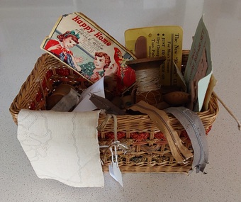
Container - Cane Sewing Basket, Happy Home, 1950's
... lived in Beenak Road, Wandin, Victoria.... lived in Beenak Road, Wandin, Victoria. Containers Sewing ...The handmade basket has a variety of pieces of vintage sewing items as listed in the detailed Description. These would have been used in the home for repairs as well as pieces sewn. Mrs Pratt owned the sewing basket and it's contents - she lived in Beenak Road, Wandin, Victoria.An open rectangular shaped cane woven sewing basket with three bands of green and tan raffia woven around the sides. It had a lid which is missing but there is one twisted wire loop where the lid would have been attached. Inside are various pieces of vintage sewing items including; large and small cotton reels with cotton thread, very small cotton cardboard reels with thread, plastic container of pins, a handmade wooden darning mushroom, a brightly coloured tin of pins and needles, two short zips, a piece of embroidery material stamped with a pansy pattern to sew, a Birch brand packet of sewing needles, a Delyta brand "Nu-Bras" Brassiere Repair Set, two "Mendex" Cuff Savers for Men's Trousers, a Happy Home Needle Book with a few needles, and a paper pattern for Cross Stitch. See above for the brands and details of the sewing items included in the basket.containers, sewing, baskets, sewing equipment -
 Bendigo Historical Society Inc.
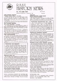
Magazine - R.H.S.V. HISTORY NEWS. NO. 78 JUNE 1987
... of Victoria Inc. 1 City Road, South Melbourne 3205. George Whithurst... VICTORIA History people and places in victoria. Royal Historical ...Three copies of the Royal Historical Society of Victoria's 'R.H.S.V History News. No. 78 June 1987.' Royal Historical Society of Victoria Inc. 1 City Road, South Melbourne 3205. George Whithurst-Richmond Chronicle, Shakespeare Place, Richmond, 3121. 6 pgs. Subscription 1987-88 applications.victoria, history, people and places in victoria., royal historical society of victoria, history, victorian history, magazines, history news, australian history, australia, victoria -
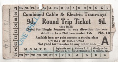 Melbourne Tram Museum
Ephemera - Ticket, Melbourne & Metropolitan Tramways Board (MMTB), "Combined Cable & electric Tramways Round Trip Ticket", c1923
... , Cotham Road, Victoria St and Collins St. Has the conditions...Melbourne Tram Museum 8 Wallen Road Hawthorn melbourne ...Ticket - card - "Combined Cable & electric Tramways Round Trip Ticket", priced 9d, over stamped "One Schilling" for a round trip using St Kilda Road, Esplanade, Glenferrie Road, Cotham Road, Victoria St and Collins St. Has the conditions of travel on the rear. Has a dated of "12-1-24" on the left hand edge. Right hand edge has been partly torn away when issued.trams, tramways, cable trams, tickets, tourist tickets, round trip -
Bendigo Historical Society Inc.
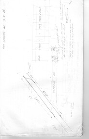
Document - MARKS COLLECTION: MAP OF EAGLEHAWK/LONG GULLY AREA
... near Mt Korong Road and Victoria Hill.... has been neatly cut out - area near Mt Korong Road ...Map of Eaglehawk and Long Gully area. Maps shows allotments and areas. Map is split down centre (torn ?) and in two pieces. Map was located in Fortuna papers, potentially belonged to G. Lansell. Section of map has been neatly cut out - area near Mt Korong Road and Victoria Hill. -
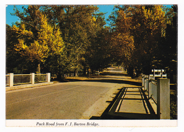 Marysville & District Historical Society
Postcard (item) - Colour postcard, Nucolorvue Productions Pty. Ltd, Pack Road from F.J. Barton Bridge, Pre 2009
... NU-COLOR-VUE/ OF / AUSTRALIA MARYSVILLE, VICTORIA. Pack... in Victoria. A colour photograph of Pack Road from the F.J. Barton ...A colour photograph of Murchison Street from the F.J. Barton Bridge in Marysville in Victoria.A colour photograph of Pack Road from the F.J. Barton Bridge in Marysville in Victoria. Labeling is incorrect. The view is looking down Murchison Street from the F.J. Barton Bridge. The F.J. Barton Bridge was named after Frederick John Barton. The Barton Family were amongst Marysville's first pioneering families. This postcard was published by Nucolorvue Productions as a souvenir of Marysville.NU-COLOR-VUE/ OF / AUSTRALIA MARYSVILLE, VICTORIA. Pack Road from F.J. BARTON/ BRIDGE. PLACE/ STAMP/ HERE POST CARD NCV.172 - NUCOLORVUE PRODUCTIONS PTY. LTD./ COPYRIGHT Printed in Australia (Note our new/ bridge) Hullo Dot,/ Very pleased to/ have the chance to meet someone who/ can tell us your news. All the best from/ all the family here at Marysville/ Terry. Dear Dot,/ Good to hear/ first hand news/ of you. Regards,/ Elsie Walkermarysville, f.j. barton bridge, murchison street, victoria, postcard, souvenir, nucolorvue productions, fj barton -
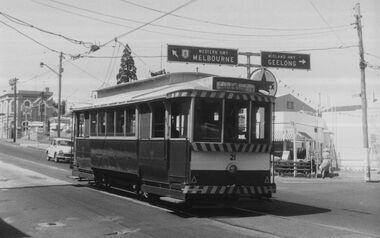 Ballarat Tramway Museum
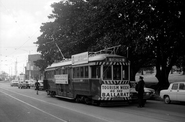
Photograph - Digital image, c1971
... at the intersection of Bridge, Victoria Streets and Main Road, inbound... at the intersection of Bridge, Victoria Streets and Main Road, inbound ...Yields information about Ballarat streetscape and its trams in the closing days of the SEC tramway system.Digital image from a black and white print of tram 21 at the intersection of Bridge, Victoria Streets and Main Road, inbound to the Gardens via Sturt St West. Has the Caltex service station, the Munster Arms Hotel in the background. CRB Road signage for Melbourne and Geelong over the tram. At Stones Corner. Photo by Marc Dahlstrom c1971. On rear is the Marc Dahlstrom stamp.trams, tramways, bridge st, victoria st, main st, stones corner, tram 21 -
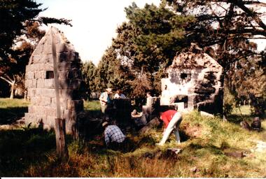 Hume City Civic Collection
Photograph, c 1993
... ) and Calder Highway (Victoria St/Mt. Alexander Road). It was part...) and Calder Highway (Victoria St/Mt. Alexander Road). It was part ...Aitkens Gap Police Lock up was originally constructed at The Gap which was south of the junction of Gap Road (Sunbury Road) and Calder Highway (Victoria St/Mt. Alexander Road). It was part of a police complex which was a changeover station for the gaol escort. The goal was relocated and rebuilt in the police station grounds in Sunbury in 1993.A coloured photograph of five men working on the removal of Aitkens Gap Gaol from its original site. Two end walls of the gaol are standing and the work is being done on the front and back of the building. Conifers and cypress trees are growing around the site.peter free, aitkens gap gaol, police historical association, sunbury police station, george evans collection -
 Ringwood and District Historical Society
Letter, Order of the Secret Monitor, Moorabbin, Victoria - Collection of Masonic Degrees and Correspondence maintained by Aird family of Ringwood, Victoria
... of Southern Australia, 12 Dane Road, Moorabbin, Victoria, confering... Road Ringwood North melbourne Letter dated 26th October, 1964 ...Letter dated 26th October, 1964 from District Grand Recorder, Order of the Secret Monitor, District Grand Conclave of Southern Australia, 12 Dane Road, Moorabbin, Victoria, confering R.Wor. Bro. A.J.B. Aird with the rank of Past District Grand Visitor in the District Grand Conclave of Southern Australia on payment of £3-3-0 fee. -
 Ballarat Tramway Museum
Photograph - Digital image, Mal Rowe, mid to late Sept. 1971
... Digital image of Ballarat Tram No. 36 in Domain Road, South... Victoria St and Domain Road for Ballarat Tourism. Driver standing ...Yields information about the operation of Ballarat No. 36 in Melbourne following the closure of the Ballarat system.Digital image of Ballarat Tram No. 36 in Domain Road, South Yarra September 1971 undertaking shuttles between Victoria St and Domain Road for Ballarat Tourism. Driver standing by front of tram with conductress walking to the rear. Behind the tram is the crossover. See also Reg Item 5995 for another Mal Rowe photo of the tram in Swanston St.trams, tramways, ballarat tourism, domain road, tourism, tram 36 -
 Bendigo Historical Society Inc.
Photograph - HARRY BIGGS COLLECTION: CNR HIGH ST. & VICTORIA ST. EAGLEHAWK, c1940's
... says Victoria St. A road sign says Neangar Park Golf Club... that is a very tall chimney. A street sign says Victoria St. A road sign ...Photograph. Harry Biggs Collection. 1 black & white photo of the corner of High St. & Victoria St. Eaglehawk. Brick building with the sign Antiques. Bric a brac hanging out on the corner. Above a white framed window is another sign ANTIQUES. Behind the shop is a brick shed 7 behind that is a very tall chimney. A street sign says Victoria St. A road sign says Neangar Park Golf Club: Echuca 40 Rochester 72. There are ornate iron safety features on all upstairs windows.place, building, commercial, harry biggs collection, cnr. high st. & victoria st., eaglehawk, antique shop -
 Orbost & District Historical Society
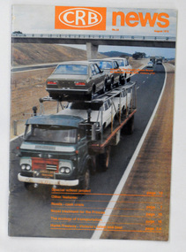
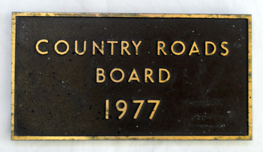
magazine, CRB News, August 1975
... for the construction and maintenance of main roads in Victoria between 1913... for the construction and maintenance of main roads in Victoria between 1913 ...The Country Roads Board was the government authority for the construction and maintenance of main roads in Victoria between 1913 and 1983. It was succeeded by the Road Construction authority on 1 July 1983 and later merged with the Road Traffic Authority on July 1 1989 to form the Roads Corporation. James Cameron, an Orbost farming pioneer and Member of the Legislative Assembly, fathered the Country Roads Board.This item is a useful research source on the Princes Highway, Gippsland.A 19 pp magazine, titled CRB ( Country Roads Board) News. It is dated August 1976. On the front cover is a coloured photograph of a truck carrying cars. In the background is a road bridge. It contains an article on the Princes Highway, Gippsland.magazine journal-crb-news princes-highway -
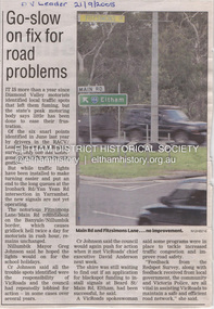 Eltham District Historical Society Inc
Document - Property Binder, Intersection of Main Road and Fitzsimons Lane, Eltham
... Major Road Projects Victoria..., June 2022, Major Road Projects Victoria, includes detail..., June 2022, Major Road Projects Victoria, includes detail ...Newspaper article: Go-slow on fix for road problems, Diamond Valley Leader, 21 September 2005, covering delay re traffic problems Ironbark Road ,Yan Yean Road, Fitzsimons Lane, Main Road roundabout. Fitzsimons Lane Upgrade, Community Update, June 2022, Major Road Projects Victoria, includes detail on landscaping at Main Road intersection.main road, eltham, property, fitzsimons lane, traffic, edendale community farm, eltham high school, landscape, major road projects victoria, porter street, roundabout, yellow box gum -
 Ballarat Tramway Museum
Photograph - Digital Image, Peter Knife, Trams 18 and 17 - Stones Corner, 24/7/1971
... , Victoria St and Main Road. Shows a busy and somewhat congested... - the intersection of Bridge St, Victoria St and Main Road. Shows a busy ...Digital image of Trams 17 (ex Victoria St) crossing tram 18 (Mt Pleasant) at Stones Corner - the intersection of Bridge St, Victoria St and Main Road. Shows a busy and somewhat congested intersection. In the background are the Caltex Service Station, a clothing shop, paint shop, dry cleaners and parking meters. Photo by Peter Knife 24/7/1971.Yields information about tram operations in Ballarat, some two months before closure of the SEC operated tram system.Digital image of a colour slide.tramways, tramcars, ballarat, tram 17, tram 18, bridge st, stones corner -
 Melbourne Tram Museum
Book - Cable tram records - book 1 of 4, Alf Twentyman, c1940 to 1985
... stock, sketch of St Kilda Road, Victoria Parade - Brunswick St... stock, sketch of St Kilda Road, Victoria Parade - Brunswick St ...First of four documents compiled by Alf Twentyman about the history of Melbourne cable trams. On the inside of the rear cover has a table of contents - see image 1. Includes sketches of San Francisco grips, sketches of destination signs on the cable cars, Auburn Road and Kew horse tram timetables rolling stock, sketch of St Kilda Road, Victoria Parade - Brunswick St, listing of ropes and their life spans, tables of cars out for various depots, timetables, list of visitors to Northcote, new MMTB rolling stock listing.Demonstrates the recording and drawing work of Alf Twentyman and his notes.Exercise book - part ruled - part plain pages - 92 numbered pages + fawn coloured covers, centre stapled.tramways, cable trams, alf twentyman, history, track plans, records -
Glenelg Shire Council Cultural Collection
Document - Antique Auction - 'Stanton Drew' Property Portland 1976, Stanton Drew, Portland, Victoria, Mar-76
... Wellington Road, Portland, Victoria, on Monday 15th March 1976... Cliff Street Portland great-ocean-road Stanton Drew 23 page ...23 page catalogue, produced by Leonard Joel Auctioneers and Valuers for the auction of antique furniture, Victoriana, china, silver, bric-a-brac etc. on the property 'Stanton Drew', 89 Wellington Road, Portland, Victoria, on Monday 15th March 1976. Glossy paper cover, burgundy and white photo of 'Stanton Drew' across front and back. Inside shiny white paper, burgundy print.stanton drew -
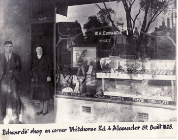 Whitehorse Historical Society Inc.
Photograph, Edwards Shop, c1923
... bought 5 acres running from Whitehorse Road to Victoria Street... Road to Victoria Street Mitcham in 1915 for 118 pounds ...Black and white photo of Edwards Shop on cnr Whitehorse Road and Alexander Street, Mitcham. Built 1923. Mr. Edwards bought 5 acres running from Whitehorse Road to Victoria Street Mitcham in 1915 for 118 pounds. Alexander Street was surveyed in 1949 later. originally accommodating a mixed business and later the local Mitcham newspaper. It currently houses a take-away food shop.edwards, william alexander -
 Melbourne Tram Museum
Document - Research Notes, H. S. McComb, development and timing of the "PMTT" part 3, 1950's
... , Glenhuntly Road, Victoria St cable tram terminus, Barkers Road... Junction, Glen Huntly Road, Glenhuntly Road, Victoria St cable tram ...Set of papers, handwritten concerning the development and timing of the "PMTT", Prahran and Malvern - about 30 sheets. Prepared by H. S. McComb - gives layout of the PMTT system, of track layout, opening dates, sketches of various junctions, bridges, track miles, junctions: Kew Junction, Glen Huntly Road, Glenhuntly Road, Victoria St cable tram terminus, Barkers Road, Commercial Road, Malvern Road, Hawthorn Road, Balaclava Junction, Caulfield station loop, Glenferrie Road. Items 2041 to 2052 within box 72.3 in a brown folder marked "PMTT" in red pencil.trams, tramways, pmtt, malvern, routes, track, kew junction, victoria st, barkers rd, glenhuntly rd, malvern rd, caulfield, hawthorn rd, balaclava rd, balaclava junction, glenferrie rd -
 Orbost & District Historical Society
plaque, 1977
... for the construction and maintenance of main roads in Victoria between 1913... for the construction and maintenance of main roads in Victoria between 1913 ...The Country Roads Board was the government authority for the construction and maintenance of main roads in Victoria between 1913 and 1983. It was succeeded by the Road Construction authority on 1 July 1983 and later merged with the Road Traffic Authority on July 1 1989 to form the Roads Corporation. James Cameron, an Orbost farming pioneer and Member of the Legislative Assembly, fathered the Country Roads Board. This plaque was possibly removed from a bridge(?) when the name was changed.A heavy rectangular shaped bronze plaque. the background is dark brown and the print and frame bronze coloured. On the back are two round recesses for screwing and attaching the plaque.COUNTRY ROADS BOARD 1977country-roads-board cameron-james -
 Ballarat Heritage Services
Photograph - Colour, Clare Gervasoni, Fawcett Hall and Public Library, 2015, 11/01//2015
... , North East Victoria, in Spring Creek Road and is set amongst... of Alexandra, North East Victoria, in Spring Creek Road and is set ...Fawcett Hall is 14 kilometres North West of Alexandra, North East Victoria, in Spring Creek Road and is set amongst a small picturesque rural farming and business community with hills as a backdrop and Stony Creek running alongside the public reserves property boundary. Part of our hall building dates back to its establishment in 1882. Originally the hall served as a Mechanics Institute and Public Library and later as a primary school.Colour photograph of a weatherboard Hall.fawcett hall and public library, fawcett, fawcett mechanics' institute -
 Orbost & District Historical Society
book, Vic Roads Centenary 1913 -2013, 2013
... of major projects, which includes the Great Ocean Road, Hume... construction in Victoria including East Gippsland. vicroads book roads ...The publication, VicRoads Centenary: Keeping Victorians Connected for 100 Years, looks at the people and projects that define VicRoads’ history. Written by current and former VicRoads’ employees, the publication details the organisation’s portfolio of major projects, which includes the Great Ocean Road, Hume Highway and Eastern Freeway. Other sections report on Victoria’s world-first road safety initiatives, VicRoads’ use of technology and sustainability measures. (ref VicRoads) This item is one of several books donated by David Jellie at a presentation to Orbost Historical Society. He was a contributor to the book and was the engineer for the Snowy River Bridge (Princes Highway) at Orbost 1974-1976.This book is a useful reference tool on the history of road construction in Victoria including East Gippsland.A thick, bound paperback book, titled "VicRoads Centenary Keeping Victorians Connected for 100 Years". On the front cover is a black/white photograph of two men working on a road. One has a pick. The book contains the history of VicRoads, photographs, maps and advertisements. Some are b/w. Others are coloured.vicroads book roads snowy-river-bridge jellie-david -
 Melbourne Tram Museum
Document - Research Notes, H. S. McComb, development and timing of the "PMTT" - part 2, 1950's
... Road, Victoria St cable tram terminus, Kew Depot, Candy Corner... Road, Victoria St cable tram terminus, Kew Depot, Candy Corner ...Set of papers, handwritten concerning the development and timing of the "PMTT", Prahran and Malvern - about 40 sheets. Prepared by H. S. McComb - gives layout of the PMTT system, primarily of Burke Road, sketches of track layout, opening dates, sketches of various junctions, bridges, track miles, junctions, reconciliation of track lengths from various sources includes Whitehorse Road, Victoria St cable tram terminus, Kew Depot, Candy Corner, St Kilda terminus, Malvern Depot, High St, Items 2041 to 2052 within box 72.3 in a brown folder marked "PMTT" in red pencil.trams, tramways, pmtt, malvern, routes, track, kew depot, burke rd, surveys, victoria st, whitehorse rd, malvern depot, st kilda, candy corner -
 Sunshine and District Historical Society Incorporated
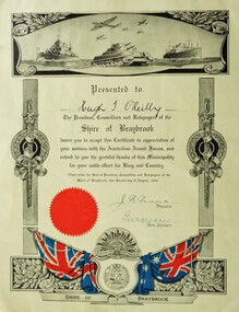
Certificate (Photocopy), Certificate in Appreciation of services with the Australian Armed Forces, Photocopy made 29/09/2015, Original made in 1946
... , NSW on 25 September 1916. He later lived in Hampshire Road...Ballarat Road, Caroline Springs, Victoria, Australia... later lived in Hampshire Road, Sunshine, Victoria, and enlisted ...Corporal Hugh Terence O'Reilly VX108560 was born in Temora, NSW on 25 September 1916. He later lived in Hampshire Road, Sunshine, Victoria, and enlisted at Sunshine with the Australian Army on 29 July 1942. He served in New Guinea, and at the time of discharge on 8 November 1945 was posted with the 22 Australian Infantry Battalion. Additional service number recorded is V37790. In civilian life Hugh Terence O'Reilly was employed in the manufacture of fibrous plaster boards.The significance is that the Shire of Braybrook, and perhaps other councils, recognised their citizens who served in the Australian Armed Forces during World War 2, by presenting them with Certificates in appreciation of their military service.Yellowish background. Grey scale diagrammatic image of warships, tank, and aeroplanes at the top. Vertical posts with swords and wreaths along the sides. At the bottom a diagrammatic image containing in colour the Union Jack and the Australian flag, the Shire of Braybrook Coat of Arms, the Australian Commonwealth Military Forces insignia, and a red coloured circular seal.Presented to Hugh T. O'Reilly. The President, Councillors and Ratepayers of the Shire of Braybrook desire you to accept this Certificate in appreciation of your services with the Australian Armed Forces, and extend to you the grateful thanks of this Municipality for your noble effort for King and Country. Given under the Seal of President, Councillors and Ratepayers of the Shire of Braybrook, this second day of August, 1946. J. R. Parsons - President, 'illegible' - Shire Secretary