Showing 29554 items
matching hill
-
 Orbost & District Historical Society
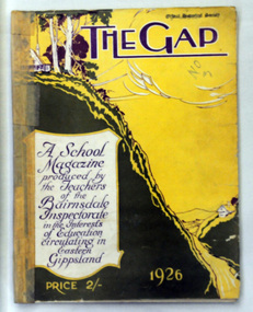
magazine, Keating Wood Pty Ltd, The Gap 1926, 1926
The first edition of this magazine was produced by associated elementary schools in the Omeo Shire. The magazine was published from 1920 to 1927 and 1963 to 1969. There was a special issue in 1985. In all issues there is writing by children from schools that have since closed down. This is the seventh annual edition of the magazine. This item reflects the changes in education in East Gippsland and is a useful comparison tool for literacy teaching. It also has historical articles for research.A 68 pp magazine with a pale yellow and olive green coloured cover. In purple print is a schoolhouse on top of a hill overlooking a gap in the hills. It contains articles on local history, b/w photographs and examples of children's work. On the front cover is the price 2/-.paper card ink -
 Clunes Museum
Photograph - PHOTOGRAPH TENNIS CLUB, THORNTON RICHARDS & CO
PHOTOGRAPH MOUNTED ON BUFF CARDBOARD PRINTED ON TOP: CLUNES TENNIS AND RECREATION CLUB PRINTED ON BOTTOM:C GRADE PREMIERS 1965-1966 LEFT TO RIGHT: S. JONES, E. HENDRICKSON (CAPT) H. TORNEY, K. GRIGG, J. HILL, B. HILLc grade premiers, tennis 1965-1966 c grade -
 Whitehorse Historical Society Inc.
Document, Land Brochures, 1929
Photocopies of sale brochures of land in Mitcham by Coghill & Haughton in conjunction with Drake & Co.Photocopies of sale brochures of land in Mitcham by Coghill & Haughton in conjunction with Drake & Co. Includes (a) General advertisement for Mitcham. (b) Station Front estate and Whitehorse Hill estate. (c) Detail of Station Front Estate. (d) Detail of Whitehorse Hill estate.Photocopies of sale brochures of land in Mitcham by Coghill & Haughton in conjunction with Drake & Co.mitcham, coghill & haughton, drake & co., the esplanade, auctions, walker, edgar edwardes, donald, station front estate, whitehorse hill estate, whitehorse road, mitcham road, barkly terrace, calcutta street, delhi street, benares street, simla street, land subdivision -
Surrey Hills Historical Society Collection
Archive - Vertical file, Athletics
A vertical file containing the following: 1. Athletic club – Surrey Hills: 6 notes from Boroondara Standard, various dates (2 pages). 2. Excerpts from Box Hill Reporter, various dates; Ken James research (18 pages). athletics club, ken james -
 Lakes Entrance Regional Historical Society (operating as Lakes Entrance History Centre & Museum)
Photograph, 1930c
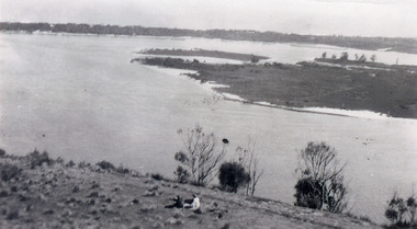
Black and white photograph, showing eastern end of Rigby Island, Snake Island, at Lakes Entrance, Victoria. Reeves Channel below foreground hill, Hopetoun Channel between dunes and islands with fish pens in distance. Two people sitting on hill in foreground.islands, waterways, topography, room display -
 Bendigo Historical Society Inc.
Slide - RALPH BIRRELL COLLECTION: EIG SCHOOL, c1966
EIG School - Ralph Birrell Collection. - Construction of Latrobe Uni. C1966. Bendigo Institute of Technology, Engineering School, Applied Science. View of possibly the Flora Hill High School or the Flora Hill Primary School from the site of the La Trobe University.Kodakeducation, tertiary, latrobe university bendigo, eig school - ralph birrell collection. - construction of latrobe uni. c1966. bendigo institute of technology, engineering school, applied science. flora hill high school flora hill primary school -
 Bendigo Historical Society Inc.
Photograph - CASTLEMAINE GAS COMPANY COLLECTION: PHOTO PEOPLE, 1963
From Left to Right: Wally Thompson ( Standing behind tool cart main layer) - Bert Hill (Foreman) - Ken Cain (Welder) - Jack Hawke (Service Layer) - Operation; preparing length of welded pipe. Early 1963. McIvor Road Hill.person, group, male group of workers -
 Bendigo Historical Society Inc.
Document - ALBERT RICHARDSON COLLECTION: THE VICTORIA HILL HISTORICAL ASSOCIATIONS
Five page handwritten document (copy) on the history of Victoria Hill, Ironbark, Bendigo. 'Gold first found in 1853 by two colored men, one named Weymouth or 'Dido' and sold to Theodore Ballerstedt Senior, who in December 1853, was known as the 'Father of the Hill'.'bendigo, mining, victoria hill -
 Bendigo Historical Society Inc.
Book - WHITE HILLS READING ROOM COLLECTION: MINUTES BOOK 1900-1907
Hardcover minutes book of the White Hills Reading Room Committee from 1900 to 1907. The book is in poor condition spine coming apart. White Hills and East Bendigo Heritage Study - Stage 2 2016 vol 2 citations FINAL_0.pdfclubs, social, white hills reading room -
Bendigo Historical Society Inc.
Document - Digital, KEN BICE COLLECTION: SPECIMEN HILL UNITED MINE
Copy of photo: (also copy) Specimen Hill United Mine, image shows poppet head in centre of image, written on side 'Specimen Hill UCMS' Piles of mullock on RH and LH side in foreground. Two ore bins in front of poppet head.bendigo, mining, specimen hill united mine, bendigo, mining, specimen hill united mine, poppet head. -
Bendigo Historical Society Inc.
Document - WHITE HILLS - OLD MINING AREA AT WHITE HILLS, 2/12/2008
Document - research prepared by Dr. Ralph Birrell - 'Heritage Preservation of Old Mining Area at the First White Hill' Research covers mining methods used in this area from 1851. The area is all that remains of the First White Hill alluvial mining site.Dr. Ralph Birrellplace, mining site, first white hill, mining, first white hills, dr. ralph birrell -
Bendigo Historical Society Inc.
Document - NEW CHUM & VICTORIA LINES OF REEF - NOTES ON VICTORIA HILL FOR TOURIST ATTRACTION
Handwritten notes outlining a plan for Victoria Hill, Central Nell Gwynne and New Chum Hill to be the focal position for a tourist attraction. Outlines steps to be taken to do the work and a mining museum at the Central Nell Gwynne. On the back of the page is a sketch of Victoria & New Chum Hills. On the plan is the Battery, Rae, Rae's House, Rae's Open Cut, Wittscheibe, Midway, Victoria Quartz, Lansell's 180 Shaft and the Recreation Reserve.document, gold, new chum & victoria lines of reef, new chum & victoria lines of reef, notes on victoria hill for tourist attraction, central nell gwynne, new chum hill, bendigo and district tourist development association, victoria hill, lansell's big 180, victoria quartz, rae, rae's house, rae's open cut -
 Surrey Hills Historical Society Collection
Digital photo, George L Coop, Mont Albert Railway Station c 1956, c1956
The donor George Lister Coop was about 19 years of age when he took this photo. It is one of a small series of photos donated by him that relate to Mont Albert and Surrey Hills stations. He has always had an interest in railways and there are other examples of his documentation of railway history in other collections contributing to this database. This documents the original building on the northern platform of the Mont Albert station. The railway line was extended out to Lilydale with work commencing in 1882. It is not known exactly when the Mont Albert station was built, but it opened in 1890. It is presumed that this building was demolished when the third line was constructed in 1971. At this time the nearby Surrey Hills original station buildings were demolished.A black & white photo of Mont Albert station taken from the north platform adjacent to High Street, looking towards Box Hill. It clearly shows the bend in the line beyond the platforms. it also shows both the original buildings; the one on the north side having been demolished. There is a lady on the south platform adjacent to Hamilton Street. The roof line only of one of the Hamilton Road shops can be seen.george lister coop, mont albert station, 1956, hamilton street shops -
Whitehorse Historical Society Inc.
Article, Robert Blood's Cottage - the battle that is not over yet, 1993
Two articles about Robert Blood's Cottage, built 1854. The cottage has been earmarked for demolition since being purchased by Box Hill Council 15 years ago. But for the last 14 years it has been home to the Director of the Oxford Children's' Theatre. The historic value of the cottage has been in question. In February 1993 the National Trust admitted it was at fault in its earlier assessment of the cottage.Two articles about Robert Blood's Cottage, built 1854. The cottage has been earmarked for demolition since being purchased by Box Hill Council 15 years ago. But for the last 14 years it has been home to the Director of the Oxford Children's' Theatre. The historic value of the cottage has been in question. In February 1993 the National Trust admitted it was at fault in its earlier assessment of the cottage.Two articles about Robert Blood's Cottage, built 1854. The cottage has been earmarked for demolition since being purchased by Box Hill Council 15 years ago. But for the last 14 years it has been home to the Director of the Oxford Children's' Theatre. The historic value of the cottage has been in question. In February 1993 the National Trust admitted it was at fault in its earlier assessment of the cottage.blood, robert, station street, box hill, benzie, edith, national trust of australia. victoria, city of box hill, oxford childrens theatre, willingham, allan, bloods cottage, box hill -
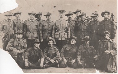 Rutherglen Historical Society
Image, 1914 (Exact)
The photo could be of some of the following: Percy Fullerton, B. Bevan. A. McPherson, A. Carter, C Eggleston, G. Libound, A. Hill, W Monan, J. Waugh, J. Slowe, J.Pearce,B. Canning, G. Ball, H. Evans. The man in the centre of the photo in the cap is Lieutenant Charles Denehy/later Colonel Denehy, the man extreme right front row is Joseph Nott.Black and white postcard photograph of group of men in uniform, 11 standing, 6 seated or kneeling in front.Written on back of photo: "Rutherglen Boys of the 7th Battalion. Sailed with the first Australian Contingent" On separate note: "Rutherglen Boys of the 7th Battalion sailed with the first Aust. Contingent. Henry Andrew (Harry) Clarkson 3rd from right, standing, back row. Back row: 5th from left - Major Gerry Chambers. Front row: 6th from left - Joseph Nott."percy fullerton, bevan, mcpherson, carter, eggleston, libound, hill, monan, waugh, slowe, pearce, cannign, ball evans, charles denehy, joseph nott, harry clarkson, gerry chambers, 7th battalion, world war 1, world war i, ww1, martin balsarini, 4th lighthorse -
 Bendigo Historical Society Inc.
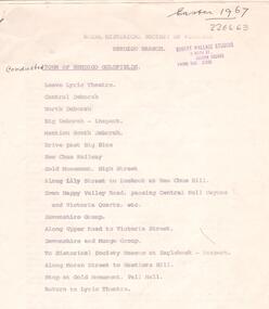
Document - ALBERT RICHARDSON COLLECTION: TOUR OF BENDIGO GOLDFIELD 1967
Seven page printed document. On top 'Royal Historical Society of Victoria, Bendigo Branch. Conducted tour of Bendigo Goldfields.' Easter 1967. Document lists the names and details of mines covered on the tour, including the : Central Deborah, corner Violet and Creek Street North Deborah, Breen Street, Quarry Hill The Deborah, off Adams Street, Quarry Hill The New Chum Railway, Breen Street, Golden Square Eureka Extended South Belle Vue. The Hustlers Hill area history. New Chum Hill history Mines on the New Chum Hill and vicinity: Lansell's 180 New Chum and Victoria The Lazarus New Chum United New Chum consolidated Garibaldi Long Gully mines The Ironbark Carlisle United Hercules Document is signed by A. Richardson.bendigo, mining, mine tour 1967 -
 Surrey Hills Historical Society Collection
Photograph, Surrey Hills looking south-east from the steeple of Holy Trinity Church, 1921
The property in the foreground is 'Edgeware' at 171 Union Road, a house built by the Zeplin family. It became the home / residence of Dr Percy Liddle and later Dr James Landells Blakie. By the time this photo was taken Dr Blakie had moved across the road to 174 Union Road. In the background behind the 2 houses in the foreground is the Surrey Hills Stationmaster's house, sitting behind a picket fence. The Alan Holt register gives a build date of c1915 for this house, which fits stylistically. The first stationmaster was probably Michael Ginnane, who stayed in the area after he retired, moving to 1 Russell Street. This property was listed as 8 Bedford Avenue, the only house on the south side of the road. It was demolished in c1972 to make way for widening of the rail track with a third line. The photographer Norman Carter took many photos of Surrey Hills and Mont Albert from the 1920s, in particular of events and activities associated with the Church of England.Black and white photo taken from the steeple of Holy Trinity Church looking across housing towards the railway line and Albany / Windsor Crescents and on towards Canterbury Road. Surrey Hills Primary School and St Stephens Presbyterian Church feature prominently on the horizon. The stationmaster's cottage is centre left adjacent to a large conifer-like tree, with a white fence delineating the railway yards.On back of original: "6-11-21" and in a different hand in biro: "from tower of Holy Trinity Church"albany crescent, windsor crescent, st stephens presbyterian church, surrey hills primary school, railways, stationmasters' houses, bedford avenue, norman carter, edgeware, dr percy liddle, dr james blakie -
Whitehorse Historical Society Inc.
Article, City council a victim of circumstances|Bureaucracy bogs down conference|Talks soon on council plan, 1972
Photocopy of three articles concerning Nunawading Council:Photocopy of three articles concerning Nunawading Council:|An unreported move by the Local Government Department has led to appeals against flats in McGhee Avenue not being delivered to the Department.|The Municipal Association of Victoria has said it cannot discuss Nunawading's motion for a tripartite conference between federal, state and local government.|Discussions will be held on a regional council including Box Hill, Camberwell, Knox, Waverley and Nunawading councils.Photocopy of three articles concerning Nunawading Council:city of nunawading, victoria. local government department, municipal association of victoria, city of box hill, city of camberwell, city of ringwood, city of knox, city of waverley, mcghee avenue, mitcham -
 Ballarat Tramway Museum
Slide - 35mm slide/s - set of 32, Noel Simons, 25/02/1971 12:00:00 AM
Set of 31 transparencies taken on 25/2/1972 on Kodak mounts. 1201.1 - Bendigo No. 26 in Bond St. just after leaving Long Gully en route for Quarry Hill. Has Norris Supermarket in background. Has two SEC roof ads. 1201.2 - No. 26 climbing View St. from Charing Cross en route to Eaglehawk. Has ANZ bank and AMOCO service station in background. 1201.3 - as for 1201.3, but after tram has passed photographer. Has buildings west of Mackenzie St. in photograph. 1201.4 - Tram stop and centre of the road pole with two "CARS STOP BY REQUEST" signs mounted on pole at the corner of Mackenzie St. 1201.5 - same position as for 1201.3, but with No. 5 descending the street. 1201.6 - same position as for 1201.2, but with No. 5 descending the street. Photo taken after tram has passed photographer. 1201.7 - No. 7 in Nolan St. from across the park at Lake Weeroona. 1201.8 - No. 7 entering McCrae St from Nolan St. - distant view. Note "TRAM "sign on left hand side under tree and overhead in McCrae St. from former track that once was in this street. 1201.9 - No. 7 in High St. with Cathedral in background. Tram en route to North Bendigo. Note scaffolding around Cathedral main spire area. 1201.10 - No. 7 crossing Bendigo Creek bridge in High St. near Golden Square. Has a Caltex Service station in the background. 1201.11 - No. 7 at Golden Square terminus with Sunburst Fruit Juices and a Peters Ice cream delivery vans alongside. 1201.12 - as for 1201.11 but photo taken from behind tram, with the end of the rails in the photograph. 1201.13 - No. 7 and 21 in Pall Mall at Charing Cross with No. 5 in the background. Taken some distance away from the location. 1201.14 - No. 7 at Golden Square terminus, taken a short distance from the tram terminus. Shows Milk Bar on right hand side and the hotel on the left hand side. Taken from the south side of the roadway. 1201.15 - as from 1201.14 but taken from the north side of the roadway. 1201.16 - No 5 waiting at California Gully loop. Distant photo showing surrounds 1201.17 - No. 5 en route for Quarry Hill crossing No. 26 at California Gully. 1201.18 - No. 26 at Eaglehawk terminus with Eaglehawk Town Hall and Post Office in background. 1201.19 - No. 21 arriving at Charing Cross en route to North Bendigo. Has Alexandra Fountain in the background, ANZ bank RACV building, and other buildings on the north side of Pall Mall or Nolan St. 1201.20 - No. 26 en route for Quarry Hill at Charing Cross, with crew standing by front door. Has Colonial Mutual life building, Armstrong Tyre Service (Firestone) and a sign for Cohns Drinks in the background. 1201.21 - as for 1201.20 but with No. 5 en route to Eaglehawk now in photograph. 1201.22 - No. 26 at Quarry Hill terminus. 1201.23 - No. 26 at Quarry Hill terminus, view of front portion of tram only from a gate at the Bendigo cemetery. 1201.24 - Track at the end of the Quarry Hill line showing the point blades of the former "Y" terminus and the overhead for this. 1201.25 - No. 2 at the Quarry Hill terminus, looking along the former Trackwork. 1201.26 - as for 1201.25 1201.27 - number not used. 1201.28 - Golden Square terminus from some distance from the actual terminus, showing the Warning sign "TRAM" for motorists from the south. No. 7 at the terminus. 1201.29 - No. 7 passing through the Golden Square shopping centre. Numerous cars and pedestrians. Tram en route for North Bendigo. 1201.30 - No. 7 in High St. Golden Square, en route for North Bendigo. Photo taken after tram has passed photographer. 1201.31 - No. 7 in High St. just past Wattle St. with the Cathedral in the background. Tram has two SEC roof ads good side on photo, 'Everything's fine in my all electric kitchen' and 'Electrical cooking - clean, quick, economical'. 1201.32 - No. 7 in High St. nearing Wattle St. Has Cathedral in the background. Photo taken after tram has passed photographer.Information written on in black ink and date stamped on purple ink. 1201.1 - "No. 26 in Bond St just after leaving Long Gully" 1201.2 - "No. 26 climbing View St. from Charing Cross" 1201.3 - "No. 26 ascending View St. from Charing Cross (At Mackenzie St.)" 1201.4 - "View St. & Mackenzie St." 1201.5 - "No. 5 in View St. near Mackenzie St." 1201.6 - "No. 5 in View St. nearing Charing Cross." 1201.7 - "No. 7 in Nolan St. seen from Lake Weeroona Park." 1201.8 - "No. 7 entering McRae St. from Nolan St. Note "TRAM" warning sign on left. 1201.9 - "No. 7 in High St. passing Short St." 1201.10 - "No. 7 crossing Bendigo Creek bridge in High St. near Golden Square." 1201.11 - "No. 7 at Golden Square terminus" 1201.12 - "No. 7 at Golden Square terminus" 1201.13 - "No 7, 21 and 5 at Charing Cross" 1201.14 - "No. 7 at Golden Square terminus" 1201.15 - "No. 7 at Golden Square terminus" 1201.16 - "No 5 waiting at California Gully loop." 1201.17 - "Nos. 5 and 26 crossing at California Gully loop" 1201.18 - "No. 26 at Eaglehawk terminus" 1201.19 - "No. 21 arriving at Charing Cross from Golden Square" 1201.20 - "No. 26 at Charing Cross" 1201.21 - "Nos. 5 and 26 at Charing Cross." 1201.22 - "No. 26 at Quarry Hill terminus" 1201.23 - "No. 26 at Quarry Hill terminus seen through the gates of the Bendigo Cemetery." 1201.24 - "Quarry Hill terminus showing remains for former double track layout abandoned before 1964." 1201.25 - "No. 2 at Quarry Hill terminus" 1201.26 - "No. 2 at Quarry Hill terminus" 1201.28 - "The Southern approach to Golden Square with No. 7 standing at the terminus, "TRAM" warning sign on the left. 1201.29 - "No. 7 passing through Golden Square Shopping Centre" 1201.30 - "No. 7 in High St. Golden Square" 1201.31 - "No. 7 in High St. passing Wattle St." 1201.32 - "No. 7 in High St. nearing Wattle St."tramways, trams, bendigo, bond st., view st., nolan st., high st., eaglehawk, california gully, charing cross, quarry hill, trackwork, tram 2, tram 5, tram 7, tram 21, tram 26 -
 Surrey Hills Historical Society Collection
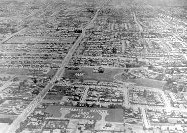
Photograph - Aerial view Riversdale Heights Estate area, c1923
This was probably part of a real estate promotion for the sale of the Riversdale Heights Estate. This was subdivided by Messrs. Duncan and Weller. Of the allotments offered, 30 were sold and realised £4600. Date of this sale was c December 1923. This suggests that the date This are was one of the last pieces of former rural land to be sub-divided for housing in Surrey Hills.The land between it and South Surrey Park was sub-divided post WW1, hence the naming of the streets after sites of WW1 battles.A black and white reproduction of an aerial photo of the area near the corner of Warragul and Riversdale Roads looking west towards the city. Some features have been identified by name including the Riversdale Heights Estate, which was being sub-divided. North and South Courts are shown. Other roads (unmarked) in the foreground are Graham Street, Allie Street, Thistle Street, Lille Street, Amiens Street, and Marne Street. Beyond these is the area marked 'PARK' (South Surrey Park), which is devoid of vegetation. Areas of Camberwell and Canterbury are also shown. The area covered extends to beyond St Dominic's Church. The original is mounted on a cream deckle-edged paper.Beneath the original on the mount: "SOUTH SURREY HILLS LOOKING WEST c. 1936" [The reference to the sale in the Box Hill Reporter of December 1923 found on Trove suggests that this date is not accurate.] Rear top LH corner of original in Jocelyn Hall's handwriting: "For Centre / from Mr James Long"riversdale heights estate, riversdale road, allie street, south surrey park, lille street, thistle street, amiens street, marne street, south court, north court, duncan and weller, real estate sales, graham street, st dominics church, highfield park, canterbury primary school, aerial photo -
 Kew Historical Society Inc
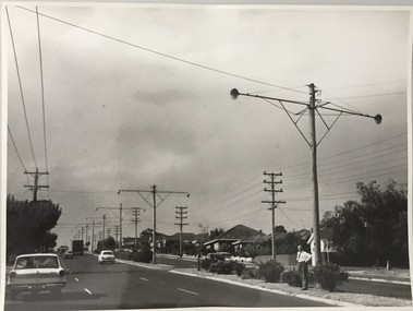
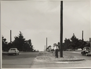
Photograph, Stuart Tompkins Studio, Electricity Supply Poles, Warrigal Road, Holmesglen, 1965
Research provided by Stuart Tompkins Studio, Box Hill, into alternatives for median strip street lighting to be used in Burke Road, Kew. The photographers identified variants in different suburbs appropriate to Kew's needs. The series from which the photograph is drawn provides a snapshot by a commercial photographic studio of each named vicinity in 1965 as well as providing examples of public works infrastructure being commissioned by local government in the 1960s. The photos originally formed part of the Engineering Department's files in the City of Kew before being donated to the kew Historical Society.Electricity Supply Poles, Warrigal Road, Holmesglen, 1965. Stuart Tompkins Studio provided this photograph for the Kew City Council. The photograph of Warrigal Road, north of Holmesglen looking north depicts wooden poles with bracket light fittings. These were the same as those proposed for Kew, except the lights and fittings were not to be 350 watt. Mercury lamps were preferred. [There are three copies of this photograph in the Collection.] Typed inscription on reverse: "Electricity Supply Poles. Photographed for Kew City Council 8/2/65. No.3 Warrigal Road - North of Holmesglen looking north. Wooden poles with bracket fittings same as those proposed for Kew except lights and fittings are not for 250 watt c. c. mercury lamps proposed. Wooden pole 3' up 11 3/4" dia." Studio stamp: "Stuart Tompkins Studio. 547 Station Street, Box Hill. WX1439."stuart tompkins studio, warrigal road (holmesglen) 1965, street lighting -
 Kew Historical Society Inc
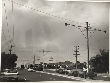
Photograph, Stuart Tompkins Studio, Electricity Supply Poles, Burke Road, Kew, 1965
Research provided by Stuart Tompkins Studio, Box Hill, into alternatives for median strip street lighting to be used in Burke Road, Kew. The photographers identified variants in different suburbs appropriate to Kew's needs.The series from which the photograph is drawn provides a snapshot by a commercial photographic studio of each named vicinity in 1965 as well as providing examples of public works infrastructure being commissioned by local government in the 1960s. The photos originally formed part of the Engineering Department's files in the City of Kew before being donated to the kew Historical Society.Electricity Supply Poles, Burke Road, Kew, 1965. This photograph of Burke Road, Kew was taken just north of Kilby and Doncaster Roads looking north. Stuart Tompkins Studio provided the photograph for the Kew City Council. In the photograph are a number of electricity supply poles that have been erected in the median strip, in addition to some new poles on each footpath. The nearest wooden pole is stated to be 13.5″ in diameter. The electricity poles in Burke Road required Kew Council to investigate comparable designs in other Melbourne municipalities. [There are three copies of this photograph in the Collection.] Typed inscription on reverse: "Electricity Supply Poles. Photographed for Kew City Council 8/2/65. No.5 Burke Road - Kew, just north of Kilby and Doncaster Roads looking north. Some of seven poles already erected in median strip. Shows also some new poles erected on each footpath. Nearest wooden pole 13 1/2" dia." Studio stamp: "Stuart Tompkins Studio. 547 Station Street, Box Hill. WX1439."stuart tompkins studio, street lighting, south road (moorabin) 1965 -
 Kew Historical Society Inc
Photograph, Stuart Tompkins Studio, Electricity Supply Poles, Burke Road, Kew, 1965
Research provided by Stuart Tompkins Studio, Box Hill, into alternatives for median strip street lighting to be used in Burke Road, Kew. The photographers identified variants in different suburbs appropriate to Kew's needs.The series from which the photograph is drawn provides a snapshot by a commercial photographic studio of each named vicinity in 1965 as well as providing examples of public works infrastructure being commissioned by local government in the 1960s. The photos originally formed part of the Engineering Department's files in the City of Kew before being donated to the kew Historical Society.Electricity Supply Poles, Burke Road, Kew, 1965. This photograph of Burke Road, Kew was taken just north of Kilby and Doncaster Roads looking north. Stuart Tompkins Studio provided the photograph for the Kew City Council. In the photograph are a number of electricity supply poles that have been erected in the median strip, in addition to some new poles on each footpath. The nearest wooden pole is stated to be 13.5″ in diameter. The electricity poles in Burke Road required Kew Council to investigate comparable designs in other Melbourne municipalities. [There are three copies of this photograph in the Collection.] Typed inscription on reverse: "Electricity Supply Poles. Photographed for Kew City Council 8/2/65. No.5 Burke Road - Kew, just north of Kilby and Doncaster Roads looking north. Some of seven poles already erected in median strip. Shows also some new poles erected on each footpath. Nearest wooden pole 13 1/2" dia." Studio stamp: "Stuart Tompkins Studio. 547 Station Street, Box Hill. WX1439."stuart tompkins studio, street lighting, south road (moorabin) 1965 -
Canterbury History Group
Ephemera - touchstones to WW1 in Balwyn, Camberwell, Canterbury and Surrey Hills, Susan Barnett, 1/04/2015 12:00:00 AM
Booklet compiled by Susan Barnett, President of the Surrey Hills Historical Society with the assistance of the Balwyn Historical Society, Camberwell Historical Society, Canterbury History Group and the Surrey Hills Historical Society, for a bus tour of significant places in Boroondara to commerate the centenary of the Gallipoli Landing.beckett park memorial, white> dorothy sevilla, cahill> francis matthew, cahill> martin, cahill> richard nicholas, cahill> kevin martin, lone pine dairy - balwyn, bignell> alfred charles, canterbury citizens carnival, canterbury gardens, soldiers - memorial hall - canterbury, canterbury memorial home units, canterbury primary school, camberwell city rsl sub-branch, golding> herbert, daly> gustav anthony disney, daly> william constant beck, daly> clarence wells didier, wattle park lone pine, clock tower memorial> wattle park, hethersett house - plc - burwood, surrey gardens - memorial cross, surrey gardens - the shrine, steele> mrs charles h d, blogg> john kendrick, gawler> john stephens, mawson> frederick w, webster> clarence -
 Buninyong & District Historical Society
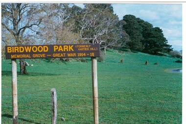
Photograph - Original Photograph, Mr. C.J. Brooks, View up Mt. Innes from Learmonth St., showing Birdwood Park sign, September 1995
connections to early settlement and WWI.Colour photo, View up Mt. Innes from Learmonth St., showing Birdwood Park sign. Conifers are WWI memorial created as Birdwood Grove. Hill has also been known as Hastie's Hill, Mt. Loch, Birdwood Park and Mt. Innes.buninyong, birdwood grove, hastie's hill, mt. loch, mt. innes -
 Bendigo Historical Society Inc.
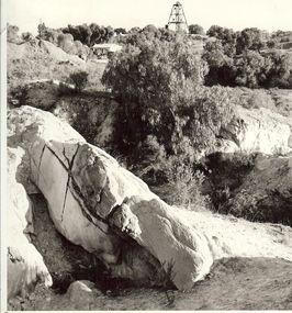
Photograph - MINE WORKINGS, ROCK OUTCROP
Black and white photo: large rock outcrop and mine working on treed hill in foreground. House in middle ground and poppet head on hilltop horizon. Victoria Hill area ? On back Wallace Studios/6 Ruth St.,/ Golden Square/ Phone Go 37565Robert Wallace Studios, Golden Squaremine, gold, mining landscape, bendigo, mines and mining, mines, mine, mining, landscape, victoria hill -
 Bendigo Historical Society Inc.
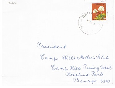
Document - BEREAVEMENT NOTE OF THANKS
Document. A printed bereavement note of thanks on the passing of Stephen James Bourke, 21 Sept. 1976, aged 66 years. Contained inside an envelope addressed (handwritten) to The President, Camp Hill Mother's Club, Camp Hill P.S., Rosalind Park, Bendigo, 3550.person, individual, personal, stephen james bourke, bereavement, camp hill mother's club -
 Bendigo Historical Society Inc.
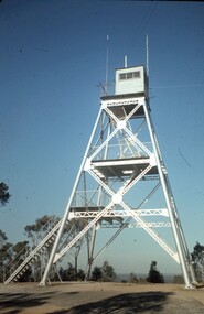
Slide - PETER ELLIS COLLECTION: SLIDE, May 1970 - Jan 1972
Coloured slide transparency. Image is of a tall metal tower on top of a hill. The tower is white and a ladder is visible on the right hand side. There are two aerials and a wooden building on the top platform. The words Lookout Tower and One Tree Hill are handwritten on the top and bottom borders.Kodachrome Transparencyslide, bendigo, bendigo institute of technology