Showing 30630 items
matching hill
-
 Surrey Hills Historical Society Collection
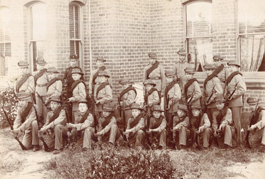
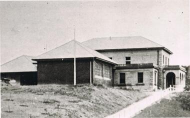
Photograph - Surrey College Cadet Corps, 1899, 1899
Surrey College was opened in early 1892 by Rev. Dr Frederick Darling who had been the first minister of the Presbyterian Church in Canterbury Road. He resigned this position to open the school which operated until 1908 with additional premises at 12 Vincent Street. The school had 40 boarders as well as day boys. Courses included algebra, euclid, history, typewriting, shorthand and drill. In the 1930s, Nethercourt Private Hospital took over the site. Later it became St Jude's Hospital. land in front of the building was subdivided off in the 1970s. The building is still extant as a private dwelling with York Street, Surrey Hills as the address. This is one of 3 photos donated by Susan Hobbs, whose grandfather Rev. George Edward Downton is thought to have been a student at the college. George E. Downton was born in Avoca in 1885. He was later a missionary in New Guinea and Secretary to the Australian Board of Missions in Adelaide. He died in 1926 or 1927. Sepia photo of 26 men and boys dressed in military uniform, many holding rifles. They are standing in front of a brick building with bay windows with blinds and curtains. There is a clump of foliage and grass in front of boys. "Surrey College - Surrey Hills / Principal: Rev Frdk. A. Darling, Melb. Univ./Cadet Corps, 1899." On the mount below the photo. Inscription on bottom right hand corner of photo: "Prepare for cavalry"schools, 1899, surrey hills, surrey college, rev frederick a darling, george edward downton, susan hobbs, union road, nethercourt hospital, st jude's hospital, 219-223 union road, cadet corps, 1890-1899 -
 Federation University Historical Collection
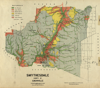
Map, Smythesdale, County of Grenville, 1888, 1889
The map maker, Ferdinand M. Krause, was a professor at the Ballarat School of Mines. This land was printed form the Crown Lands Department, Melbourne. Coloured map of the County of Grenville. The edge has been taped. The scale is 40 chains to 1 inch. The map is accompanied with a foolscap sheet printed by the Mines Department in 1898. It is a Report on the Parish of Smythesdale by F.M. Krause and includes information on the water reserve, worked quartz veins, Watson's Hill, Surface Hill and Sugarloaf Hill, Haddon, Trunk Lead and the Crucible Shaft. smythesdale, krause, f.m. krause, ferdinand krause, nitingbool, watson's hill, surface hill, sugarloaf hill, haddon -
 Phillip Island and District Historical Society Inc.
Photographs, c 1900
Four photograph enlargements from John Jansson's collection. Farm work on three properties: Underdown's farm, Rhyll; Harbison's - wool being carted for shipment to Melbourne by Ketch from Cowes Jetty; McIlwraith's farm harvesting hay at their property called "Heath Hill" at Rhyll.Four enlargements of original photographs and postcards mounted on cardboard for display purposes. 292-01 Norm Smith with a four horse team preparing ground for Chicory. 292-02. Wool Team on road to Cowes 292-03. Horse and dray loaded with stacks of hay - workers in background at McIlwraith's farm "Heath Hill", Rhyll 292-04. Horse and dray with family including ladies and children.292-02. Many Happy Returns. Good Luck. Phillip island - Wool Team on road to Cowes. 292-03. Harvest time on Phillip Island. Victoria underdown, harbison, mcilwraith, heath hill, chicory farming, wool carting, john jansson -
 Surrey Hills Historical Society Collection
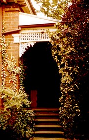
Photograph, Tavistock at 192 Union Road, 1978
The date is approximate. Tavistock was built c1890. In 1897 it was the home of the Walker family; Joyce Walker later became matron of Mosgiel Hospital. In 1902 it became the first site of Milverton Girls School. From 1930s to 1960s it was home to Miss Marjorie Vahland, a locally well-known nursing sister. See History Walks No 5, p 11 and p32 Surrey Hills In Celebration of its Centennial 1883-1983.Colour photo of the front steps at Tavistock at 192 Union Road, Surrey Hills taken from the front garden during the period of restoration during 1978-1982. The house is Victorian in style, of red brick construction with a patterned slate tile roof and decorative chimneys. The photo shows the wrought iron detail on the verandah.tavistock, milverton girls school, victorian style, houses, 1890-1900, union road, joyce walker, marjorie vahland -
 Surrey Hills Historical Society Collection
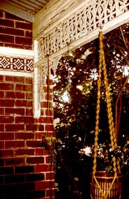
Photograph, Tavistock at 192 Union Road, 1978
The date is approximate. Tavistock was built c1890. In 1897 it was the home of the Walker family; Joyce Walker later became matron of Mosgiel Hospital. In 1902 it became the first site of Milverton Girls School. From 1930s to 1960s it was home to Miss Marjorie Vahland, a locally well-known nursing sister. See History Walks No 5, p 11 and p32 Surrey Hills In Celebration of its Centennial 1883-1983.Colour photo of the detail of the wrought iron decoration and the decorative tiles on the front verandah at Tavistock at 192 Union Road, Surrey Hills taken from the under the verandah during the period of restoration during 1978-1982. The house is Victorian in style, of red brick construction with a patterned slate tile roof and decorative chimneys.tavistock, milverton girls school, victorian style, houses, union road, 1890-1900, joyce walker, marjorie vahland -
 Bendigo Military Museum
photograph - Cartographic Squadron Production – Army Survey Regiment, Fortuna, c1980
This collection of 12 photos was most likely taken in 1980. The photos were most likely taken in Cartographic Squadron’s Ante Room, the Attic and small offices on the top floor of Fortuna Villa. The computer based Editwriter typesetting system was introduced in 1975 as a replacement to the aging Fotosetter machine. It was operated by a specialised technician, who generated a large variety of map type styles and sizes quickly and reliably, as well as text panels. CPL Richards performed this task for several years and in photo .1P and .2P is reading off a type order next to the computer monitor. Output on Copy proof adhesive backed stripping type film replaced messy wax and spray adhesives in 1978. The Editwriter capability supported all RASvy units and contractor type setting requirements. Scribing was the cartographic process of drafting features such as drainage, relief, vegetation, roads and culture on specially coated map reproduction material. The cartographic technician scribed out the map feature such as a contour to a specified line width on the map sheet, using a tool affixed with a sapphire tipped cutter. The quality control edit (Proving) stage of map production was the first opportunity to inspect a proof of the map independently and systematically. Proving tasks were carried out by technicians conversant of the map product specification and task requirement, however, was not involved in its production. Corrections were identified, marked up and sent to back to the correcting section or contractors. Terrain Embossing was a manual map production technique to produce hill shading on medium to small scale graphics and air charts. SPR John Martin is seen in photos .8P to.10P using a fine embossing metal stylus to push down on the drainage impression on a thin malleable opaque plastic material (AK Poligraphy). Ridge lines were then pushed down using the contour impression as a guide, on the opposing side of the AK Poligraphy to create a 3D plastic model terrain effect. The map impression was sprayed with white paint and photographed to create a contone tone hill shade. SPR Gina (Coore) Neilson is seen in photo .11P washing a contone positive of a land mass in a solution. The contone components were registered to the map sheet, as shown in photo .12P and masked using an air brush and a halftone negative was then created. The terrain embossing method of producing hill shading was more efficient to produce than previous specialised artistic methods such pencil/eraser and air brush. Furthermore, a more consistent enhancement of terrain on charts was achieved between technicians.This is a set of 12 photographs of Cartographic Squadron performing four map production tasks at the Army Survey Regiment, Fortuna, Bendigo c1980. The first ten photographs were on 35mm negative film and were scanned at 96 dpi. Photos .11P and .12P were on photographic paper and scanned at 300 dpi. They are part of the Army Survey Regiment’s Collection. .1) - Photo, black & white, c1980, Editwriter typesetter, CPL Paul Richards. .2) - Photo, black & white, c1980, Editwriter typesetter, CPL Paul Richards. .3) - Photo, black & white, c1980, Scribing contours on a RAAF Chart, SPR Megan (McBurney) Reynolds. .4) - Photo, black & white, c1980, Scribing contours on a RAAF Chart, SPR Megan (McBurney) Reynolds. .5) - Photo, black & white, c1980, Scribing contours on a RAAF Chart, SPR Rod Skidmore. .6) - Photo, black & white, c1980, Scribing contours on a RAAF Chart, SPR Rod Skidmore. .7) - Photo, black & white, c1980, Formal quality control edit (Proving), CPL Ian Belmont. .8) - Photo, black & white, c1980, Hill Shade Terrain Embossing, SPR John Martin. .9) - Photo, black & white, c1980, Hill Shade Terrain Embossing, SPR John Martin. .10) - Photo, black & white, c1980, Hill Shade Terrain Embossing, SPR John Martin. .11) - Photo, black & white, c1980, Hill Shade Terrain Embossing, SPR Gina (Coore) Neilson. .12) - Photo, black & white, c1980, Hill Shade Terrain Embossing, unidentified..1P to .10P No personnel are identified. .11P and .12P annotated ‘Terrain Embossing’royal australian survey corps, rasvy, army survey regiment, army svy regt, fortuna, asr, carto -
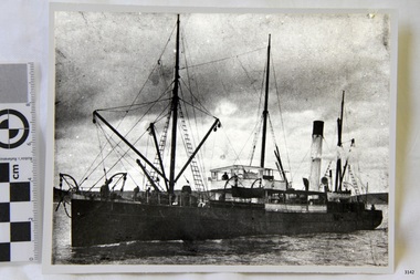 Flagstaff Hill Maritime Museum and Village
Photograph
Black and White Photograph of S.S Casino taken 1930-1932. Ship has men on deck and a man at the helm. Hills and the shore can be seen in the background. The S.S. Casino was a passenger and freight steamer built in Dundee, Scotland, in 1882 for the Newcastle and Hunter River Steam Navigation Company of N.S.W. She weighed 425 tons gross with a length of 160.4 feet, beam of 24.1 feet and depth of 10.2 feet. She had saloon accommodation for 35 people, forecabin for 25 more people, and she carried 300 tons of cargo. While on her delivery journey on May 30th 1882 the S.S. Casino called in at the Port of Warrnambool for coal ., narrowly escaping going ashore in gale force winds due to the quick action of the pilot. At that time, still at anchor, she impressed the directors of the Belfast and Koroit Steam Navigation Company so much that they bought her immediately; she was ideal for trade in along the West Coast of Victoria. (Belfast is the original name for Port Fairy, South West Victoria. The Belfast and Koroit Steam Navigation Company was first managed by Messers. Saltau and Osburne and after the passing of Mr. Osburne, by produce merchants Messers H. Sautau and Sons, whose had a hay and corn store and shipping agency was on the corner of Liebig and Koroit Streets in Warrnambool. ) The S.S. Casino became “the most famous steamer to operate in Victorian waters along the West Coast” by author Jack Loney. Captain Boyd was her first Master, followed by Captain Chapman, who stayed with her 1890 until 1924. Captain W. Robertson followed for a short term, then Captain Middleton then took command 1925 - 1932. The S.S. Casino had several mishaps during her life. One was on 3rd January 1898 when she collided with the S.S. Flinders in Apollo Bay with minor damage. Another was on 24th October 1924 when she grounded on a reef at Point Hawdon near Grey River and most of her cargo (of Christmas goods) had to be dumped into the sea. Then in February 1929 she was ‘holed’ when she struck a submerged object as she entered Lady Bay, Warrnambool. On the morning of 10th July 1932, after attempting to berth at Apollo Bay jetty in heavy seas, Captain Middleton decided to take her out into the bay and wait until the seas abated. It was not realised that the anchor used to steady her as she manoeuvred to her berth had pierced her hull. She put about and headed for the beach but sank. Captain Middleton and nine others lost their lives; nine people were rescued including the two female passengers . Captain Middleton had been in charge of the S.S. Casino for seven years. He was the first ship’s Master to lose his life through shipwreck in the West Coast trade. In the years following the turn of the century the S.S. Casino remained the only regular trader with normal passenger accommodation along the West Coast. From 1882 she had made at least 2,500 voyages on the one run. Flagstaff Hill’s collection has a photograph of a portrait of Captain Chapman, , a ship model of the S.S. Casino that shows both forms of power under which she sailed, steam and sail. The ship is painted green and flies three flags. The inscription across the case of the ship model, incorrectly dated, tells the sad story of the wreck of the ship and the loss of lives on July 10th 1932 at Apollo Bay. A print in the Collection show S.S. Casino underway in heavy sea off Point Lonsdale, another two photographs show her at the Port of Warrnambool, leaving from the Breakwater in Lady Bay and another identifies the S.S. Casino as a ship from the Belfast and Koroit Steam Navigation Company. (Belfast is the original name for the township of Port Fairy). This ohotograph is significant because of its association with the coastal trader S.S. Casino 1882-1932 and its significance to trade along Victoria's West Coast in the late 19th and early 20th century. The wreck of the S.S. Casino is considered an important part of Victorian and Australian cultural heritage and as such has been declared and protected as an Historic Shipwreck under State and Commonwealth Law in the Commonwealth Historic Shipwrecks Act (1976). Black and White Photograph of S.S Casino taken 1932-1932. Ship has men on deck and a man at the helm. Hills and the shore can be seen in the background.flagstaff hill, warrnambool, shipwrecked coast, flagstaff hill maritime museum, maritime museum, shipwreck coast, flagstaff hill maritime village, great ocean road, newcastle and hunter river steam navigation company, belfast and koroit steam navigation company, h. sautau and sons, s.s. casino, west coast trader s.s. casino, victorian coastal trader, captain boyd, captain w. robertson, captain chapman, captain middleton, apollo bay shipwreck, s.s. casino at lady bay warrnambool, saltau and osburne -
 Bendigo Historical Society Inc.
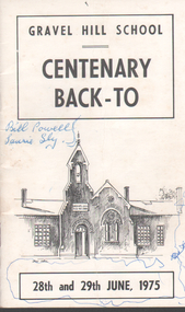
Programme - Gravel Hill School: Centenary Program, 1975
Gravel Hill Primary School No. 1566 replaced the Sandhurst School. It was designed by H R Bastow, the chief architect of the Education Department and was opened in 1875 at 65-71 Mundy Street, Bendigo.The school closed in 1992 and the site was taken over by the Salvation Army.Gravel Hill School - Centenary Back-To Souvenir Program. Dates on front cover: 28th & 29th June 1975 Cover made of light cardboard, black & white with a drawing of the school Inside pages of program are printed on white paper with black & white photos on some pages Autographs in blue ink on back cover Small writing on back cover at the bottom states that 'Printed Offset by Cambridge Press, Bendigo' souvenir programme, gravel hill school -
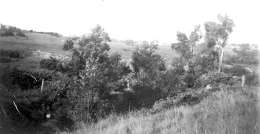 Surrey Hills Historical Society Collection
Photograph, View from Goodwood Street, Surrey Hills in 1930, 1930
The Breeden family came to Surrey Hills in 1905, first to Guildford Road, then Middlesex Road where Horrie Breeden lived as a boy. He sometimes used to help with milking at the adjoining Kenneally's dairy in Highfield Road. Sometimes he and his brother drove the cows from there to Schneider's property near Florence Road on the way to Surrey Hills Primary School. The cows would graze here until the boys took them back after school. At other times he would deliver milk from the Croydon Road dairy (Isherwood's or Bovill's) to St Joseph's Boys Home before school. Horrie became an apprentice in woodwork / carpentry at Vine's timber yard before serving in World War 1. Horrie's father died in 1919 and in the same year he bought 3 cows and established his own dairy on his mother's property on the corner of Goodwood Street and Boisdale Road. In the 1920s Horrie built the first house in Goodwood Street. He went on to build others in the street including his own at No 7 Goodwood Street. He did all the joinery and internal fittings for this. [REF: Oral testimony: Horrie Breeden to Jocelyn Hall in 1979.] In the 1990s the owner of 7 Goodwood Street discovered a branding iron under the house; this is presumed to relate to Horrie Breeden's dairy. It was donated to SHNC's collection. Horrace Bruce Breeden (7 July 1898-24 January 1988) was son of Charles Henry Breeden and Lavinia Maria Darby, both born Warwickshire; buried in Box Hill Cemetery. He was one of a large family. He married Olive Mary Romey.Black and white photo taken from the east end of Goodwood Street, Surrey Hills in 1930, looking towards Elgar and Riversdale Roads. It shows an area which is rural in appearance. It is not built upon. The foreground is grassy and there is a post-and-wire fence to the right. There is a bank of eucalyptus trees behind which is hilly grassland.goodwood street, dairies, horace breeden, horrie breeden -
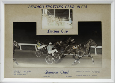 Victorian Harness Racing Heritage Collection at Lord's Raceway Bendigo
Photograph - Framed photo finish, Greg Matthews Photo, Glamour Chief, 21 January 1975
Glamour Chief won the Bendigo Pacing Cup on the 21 January 1975, followed by Yallara and Go Van. Glamour Chief owned by M Robinson, WR Lanyon, B & C Hill, was trained and driven by RA Robinson. Glamour Chief raced from 1970 (2yo) through to 1976 (8yo). Career: 29 wins 9 seconds 4 thirds 59 starts. Refer to Identifier 15.127 (Media) for Full Career Performance Record. Two colour photographs, one small one large in a white frame. At the top: Bendigo Trotting Club 21-1-75/ Pacing Cup At the bottom: Left corner: Distance 2615 metres/ Mile rate 2.6.2/5 / Greg Matthews Photo Centre: Glamour Chief (Chief Rainbow - Dainmont) / Yallara 2nd / Go Van 3rd Right corner: Owned by- M Robinson, WR Lanyon, B & C Hill/ Trained and driven by - RA Robinsonbendigo harness racing club, horses, race, winner, bendigo trotting club, pacing cup, driver, trainer, owner, 1975, glamour chief, ra robinson, m robinson, wr lanyon, b & c hill, yallara, go van, rex robinson -
 Whitehorse Historical Society Inc.
Document, Cr. John Stevens Gawler, 24/09/1951 12:00:00 AM
Copy of Letter of Appreciation sent to J. S. Gawler regarding his services as a Councillor of the City of Box Hill, and to local government beyond Box Hill, from 1921 to 1951, signed by nine Councillors and two City Officers.Copy of Letter of Appreciation sent to J. S. Gawler regarding his services as a Councillor of the City of Box Hill, and to local government beyond Box Hill, from 1921 to 1951, signed by nine Councillors and two City Officers.Copy of Letter of Appreciation sent to J. S. Gawler regarding his services as a Councillor of the City of Box Hill, and to local government beyond Box Hill, from 1921 to 1951, signed by nine Councillors and two City Officers.councillors, city of box hill, gawler, john stevens -
Whitehorse Historical Society Inc.
Article, Fifty x Fifty, 2009
An exhibition in the Box Hill Art Space at Box Hill Town hall celebrating the 1950s.An exhibition in the Box Hill Art Space at Box Hill Town hall celebrating the 1950s. Historical groups combined to put on a display of art, clothing, etc. Includes a list of exhibits, a page from Housekeeping Monthly and an invitation to the opening.An exhibition in the Box Hill Art Space at Box Hill Town hall celebrating the 1950s. fifty x fifty exhibition, whitehorse historical society inc., davison, graeme, harris, helen -
 Bendigo Historical Society Inc.
Slide - HORWOOD COLLECTION: DEBORAH EXTENDED, c1965
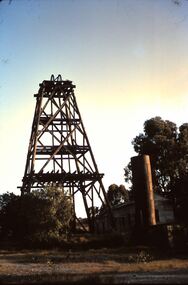
Horwood Collection. Wooden poppet head with corrugated shed and metal sheet chimney alongside. Deborah Extended Mine at Quarry Hill. Markings: Wooden 'Legs' Deborah Ext'd? Q Hill Golf Links. Used as a teaching aid.Kodakmine, gold, deborah extended -
 Uniting Church Archives - Synod of Victoria
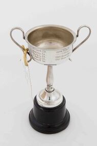
Trophy
Small silver plate trophy with a handle on bakelite/plastic base. Ticket attached to one handle with gold coloured tape.Front: "Rays Methodist Girls" Back: "1989 Albert St, 1961 Barkly St, 1963 Albert St, 1965 Burnbank St, 1960 Barkly St, 1962 Barkly St, 1964 Nhill, 1966 Brown Hill, 1967 Brown Hill -
 Bendigo Historical Society Inc.
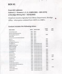
Document - MINING WARDEN COLLECTION
Historical mining records originally from the Mining Warden's Office, Mines Department, Bendigo. A summary document lists the mine name; the BEN #; the line of reef located on, the start and end year. Information collated from 1870's to 1980's. Each mine's data is enclosed in a manilla folder within the box. Mines along the following reef lines are described: Huntly Deep Lead Whipstick Neilborough Drover Isabella Slaughteryard Blue Jacket Tyson One Tree Hill Flag Gravel Hill View Hill Lightning Hill Hustlers Ben # range from 2001 to 2274. Example of entry: Pascoe and Symmonds, Ben # 2217, Lightning Hill Reef, 1863-1885.bendigo, mining, mining warden records -
 Federation University Historical Collection
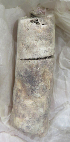
Object - Candle Remnant, Candle remnant from early Two Ballarat mines, c1860 ?
From the Britannia Mine (Ballarat) Candle remnants from early Ballarat mines are quite rare..1) White/cream candle remnant. Candle mold seams are evident. Stored in green pharmaceutical tin with screw lid. (?) Found when removing for filling motor spaces Camp Street. .2) white candle remnant from the Britannia Mine at Cambrian Hill held in a 'Barker Cake Container; tin. A handwritten note inside the tin indicates 'Piece of Candle from Mullock's Britannia Mine. Ballarat. .2) Piece of Candle The Great Leviathan Quartz Mining CosMine at Cambrian Hill near Ballarat. Picked up by Donald Doyles Mather whilst cleaning out Ballarat South Goldfield Co's Leviathan Shaft when reopening "Great Leviathan in in the year 1948. The candle was last used by miners in the Great Leviathan in the drive where found Year G. Leviathan Closed down "______" mining, candle, lard, great leviathan, donald mather, cambrian hill, great leviathan quartz mining company -
 Kiewa Valley Historical Society
Photograph - Folder of Photographs – Photocopied set of 10 black and white photographs (pages 29 - 38) from the display folder put together by KVHS to document life on the Kiewa Valley Hydro-electric Scheme
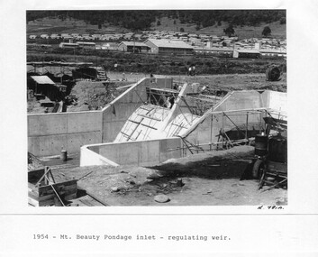
Although the Kiewa Hydro-Electric Scheme was first proposed in 1911, construction did not commence until 1938. As part of the push to cut electricity costs and diversify supply, the Victorian Government (circa 1930) initiated the conversion from primarily brown coal supply to hydro – electricity. Field investigations during the 1940’s resulted in a new proposal for a scheme that had more than double the capacity of the 1938 scheme. The Kiewa Hydroelectric Scheme became the largest scheme of its kind in the State Of Victoria and the second largest scheme in Australia. The number of personnel involved in the planning and construction of the scheme increased dramatically. During the late 1940’s, most activity centred around the construction of the West Kiewa Power Station, Rocky Valley Reservoir, McKay Creek Power Station and the Bogong Creek Aqueduct.A common thread across all the larger hydro scheme constructions was the need for workers, both qualified and unqualified who came from around the world seeking a new life for themselves and their families. New accommodation and facilities were required for the army of workers engaged in construction in often remote and wild areas. The SEC had a high demand for timber, and set up the first of a number of sawmills at Bogong Creek in 1939 and set up the first hardwood logging in the headwaters of the Kiewa River. These new ‘towns’ such as Mt Beauty and Bogong, survived, serving the needs of operational personnel and their families, and expanding with growth of new industries. Mount Beauty, and to a lesser extent Bogong, are among these places. Large A3 size spiral bound display folder containing 21 pages of photocopied black and white photographs of various aspects of the early days of the Kiewa Valley Hydro-electric scheme including equipment, various work sites and photographs of workers and their families. 1-Mt Beauty Pondage inlet-Regulating weir 2-Langfords Gap Basalt Hill-Tunnel in quarry face.3-Rocky Valley Camp-from Engineering Office 4-Basalt Hill tunnel portal 5-No 1 Pressure Shaft Works Bench 6-No 1 Power Station 7-Overturned haulage wagons on the side of an embankment 8- Group of workers dressed in wet weather gear inside a tunnel 9-Workmen and vehicle in tunnel 10-Howman’s Gap campsite at 4,150 feet 1-1954 – Mt Beauty Pondage inlet – Regulating weir Page number 29 2-28/10/54 – Langfords Gap Basalt Hill – Tunnel in quarry face K7860 Page number 30 3-STATE ELECTRICITY COMMISSION OF VICTORIA Date: 17.8.55 Time: No K8132 Kiewa Hydro Electric Works ROCKY VALLEY CAMP – FROM ENGINEERING OFFICE Page number 31 4-28/10/54 – Basalt Hill tunnel portal K7859 Page number 32 5-No.1 Pressure Shaft Works Bench 5.7.56 Page number 33 6- No. 1 Power Station 26.4.59 Page number 34 7- No markings Page number 35 8-No markings (Wooden board on ground printed with - POLAR A.N.GELATINE DYNAMITE “75” DE 28.8.40) Page number 36 9-No markings Page number 37 10-Howman’s Gap campsite at 4,150 feet Page number 38 secv; kiewa hydro electric scheme; mt beauty; bogong; construction area -
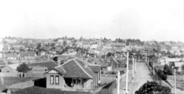 Surrey Hills Historical Society Collection
Photograph, Surrey Hills viewed from 'Quamby' at 293 Mont Albert Road, c 1915, 1915
Quamby was built in 1898. From 1900/1903-1924 it was the home of Andrew Sherar and family. From 1924-1960s it operated as Mosgiel Hospital under the direction of Matron Elizabeth Anderson. Until Box Hill Hospital opened most Surrey Hills children were born at Mosgiel or at Nethercourt Hospital in Wilson Street or later in Union Road when Matron Tank moved her hospital here. Mosgiel Hospital was demolished c 1975 after it was sold by Box Hill Hospital. It was replaced by units. Andrew Sherar was conductor of the Wyclif Church choir for many years and was a member of the Melbourne Liedertafel. Isie Sherar was organist at Wyclif Church and also taught piano in Union Road. Connie Sherar was in the Wyclif choir and married Ernest Swan, an elocutionist and orator. Dorothy Sherar was a pianist and accompanist. Elsie Sherar was also in the Wyclif choir and was a soloist; she later moved to Templestowe. Ken Sherar was a boy soprano at St Paul's Cathedral; he later moved to Queensland.Black and white photo looking south down Vincent Street from 'Quamby', located at 293 Mont Albert Road, Surrey Hills. In the centre foreground is a timber house with 2 chimneys and a tiled hip roof. It has a return veranda and is fenced on 2 sides by paling fences and picket fences on the other two. In the background are many more houses. A road lined with power poles runs from the right foreground to the middle distance.quamby, vincent street, edwardian style, topography, andrew sherar, isie sherar, connie sherar, dorothy sherar, ken sherar, elsie wappet -
 Flagstaff Hill Maritime Museum and Village
Book, Mechanical Engineers Handbook
Mechanical Engineers Handbook Author: Lionel Marks Publisher: McGraw-Hill Date: 1930warrnambool, shipwrecked-coast, flagstaff-hill, flagstaff-hill-maritime-museum, maritime-museum, shipwreck-coast, flagstaff-hill-maritime-village, shipwrecked-artefact, book, mechanical engineers handbook, lionel marks -
 Phillip Island and District Historical Society Inc.
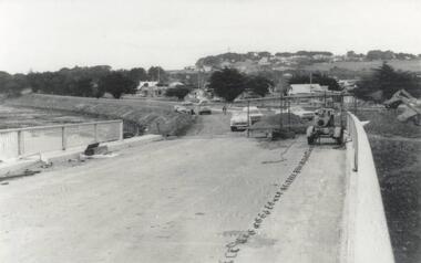
Photograph, Phillip Island Bridge, 1968/9
Construction of 2nd 1969 Bridge which was opened November 1969. From the Jack Jenner CollectionNew Bridge almost completed. San Remo in background with rising hill. Tractor on Bridge.local history, photographs, civil engineering, bridges, phillip island bridges, black & white photograph, jack jenner collection, public construction -
 Phillip Island and District Historical Society Inc.
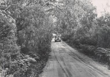
Photograph, Bryan West
One of a collection of over 400 photographs in an album commenced in 1960 and presented to the Phillip Island & Westernport Historical Society by the Shire of Phillip IslandPhotograph looking down Coghlan Road near Lamberts Hill with old car centrallocal history, photography, photographs, lamberts hill, motor car, black & white photograph, old cars, coghlan road phillip island, john jenner, bryant west -
 Greensborough Historical Society
Book, Shire of Eltham, Shire of Eltham Handbook 1988, 1988_
The Shire of Eltham was a Local Government Area located about 25 kilometres northeast of Melbourne. The shire covered an area of 277.13 square kilometres and existed from 1856 until 1994.Guide to services provided by Shire of Eltham52 pages, illus. Front cover is a copy of the painting "Panton Hill" by David Armfield.eltham, shire of eltham, handbooks -
Glenelg Shire Council Cultural Collection
Negative - Glass Plate Negative - View of pastoral property from hill, 1890-1910
Stereoscopic glass plate negative. Image shows a view of pastoral property from hill. -
Eltham District Historical Society Inc
Photograph, George W. Bell, Williams' Cottage Christmas Hills, 1969
Black and white photograph of shed wall detail Williams' cottage Christmas Hills 1969.williams, houses, eltham yarra glen road, christmas hills, george w bell collection -
 Ringwood and District Historical Society
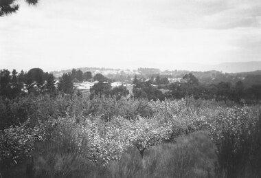
Photograph, Site of Norwood High School. Orchard leased by Peter Vergers, owned by Airds." Dated 1958
Black and white photograph of orchard in bloom. Settled area in mid ground with hills in background.Typed below photograph, "Site of Norwood High School. Orchard leased by Peter Vergers, owned by Airds." Dated 1958. -
 Flagstaff Hill Maritime Museum and Village
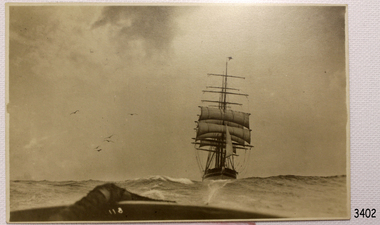
Postcard
Back and White postcard of the sailing ship Scottish Hills. (SH 275 Ships S)flagstaff hill, warrnambool, shipwrecked-coast, flagstaff-hill, flagstaff-hill-maritime-museum, maritime-museum, shipwreck-coast, flagstaff-hill-maritime-village, post card, scottish hills, postcard, sailing ship, postcard -
 Flagstaff Hill Maritime Museum and Village
Book, Steam Turbines
Steam Turbines Author: Joseph Wickham Roe Publisher: McGraw Hill Date: 1911 warrnambool, shipwrecked-coast, flagstaff-hill, flagstaff-hill-maritime-museum, maritime-museum, shipwreck-coast, flagstaff-hill-maritime-village, shipwrecked-artefact, book, steam turbines, joseph wickham roe -
Glenelg Shire Council Cultural Collection
Photograph - Photograph - Forthrop Lagoon, n.d
Port of Portland Authority Archives -
Glenelg Shire Council Cultural Collection
Photograph - Photograph - Fawthrop Lagoon, n.d
Port of Portland Authority Archivesport of portland archives, fawthrop lagoon -
 Bendigo Historical Society Inc.
Photograph - LA TROBE UNIVERSITY BENDIGO COLLECTION: OLD COURTHOUSE BENDIGO
A black and white photograph of the Bendigo Courthouse situated on the hill above Rosalind Park in Bendigo.bendigo, education, old courthouse, la trobe university bendigo collection, collection, bendigo teacher's college, buildings, courthouse, old courthouse, education, tertiary education, teacher training, photograph, photographs, photography