Showing 7321 items matching "1891-1996"
-
 Glen Eira Historical Society
Document - A'Beckett Family
4 documents which have references to the a’Beckett family. Photocopied extract from Burke’s Colonial Gentry Vol 1 1891 on the name a’Beckett, William Arthur Callander Handwritten research on various a’Beckett family tree members taken from Burke’s Colonial Gentry etc, includes rate details of home in Alma Street Leaflet on The Briars Mornington giving history on family and the Napoleonic collection of furniture Photocopied article on a’Beckett name taken from ‘Sand, Swamp and Heath by Peter R Murray and John C Wells 1980. This paragraph gives the connection to Emma Minna a’Beckett who married Arthur Boyd. Boyd’s father owner Glenfern on the corner of Hotham and Inkerman Street. This is the beginning of the artistic Boyd family in Murrumbeenaa’beckett william arthur callander, mills emma, boyd arthur merric, a’beckett thomas turner, alma street, a’beckett emma minnie, glenfern, house names, hotham street, inkerman street, alma road -
 Phillip Island and District Historical Society Inc.
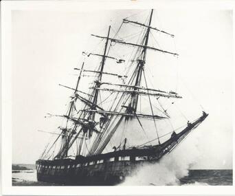
Photograph, The Speke, 22/02/1906
The Speke was an all steel ship of 310 feet, beam of 35 feet and weight of 2,712 tons and triple masted. She was built in 1891 at Carnarvon in Wales for a cost of 22,000 pounds. The wreck of the Speke was purchased for a mere 12 pounds after it went aground in 1906. The Speke had come from Peru to Sydney. She was then on her way to load wheat in Geelong when she ran aground on the 22 February 1906. Captain Tiltson confused a bushfire, near Cowes, for navigation lights. The ship drifted close to shore in Kitty Miller Bay and was eventually holed at 3 pm on the rocks. Life boats were immediately lowered and the ship’s crew all made it to shore except Seaman Frank Henderson, who lost his life.Black & White photograph of The Speke running aground on the south coast of Phillip Island.wreck of the speke, the speke, jack loney -
 Kiewa Valley Historical Society
Mantle for Gas Lantern
Originally these mantles where produced to be used in gas street lights in Europe and North America cities.There use started in 1891. These mantles were used before electrical power street lighting was installed. They have been used ever since until safety concerns regarding radiation from their thorium infused particles made alternate mobile lamps more attractive. The age of open flame recreational lighting is fast coming to a close. The greater use of battery and generator powered lighting(ease of operation) has brought the costing of these alternative lighting to an acceptable level. The age of miniaturisation and volatility of the open flame has seen a greater swing to smaller and more stable lighting. These incandescent gas mantles were initially used in the Coleman White Gas LanternsThe Kiewa Valley, with its closeness to the Victorian Alps, allows greater opportunity for the "happy" campers to enjoy the outdoors. The lighting provided by the incandescent gas lamps allow the adventurer at heart to enjoy an alternative lifestyle and still having the comforts of "home" at their finger tips. The numerous camping facilities in the Kiewa Valley and the upper alpine region is testament that those living in the cities need a break from the day to day grind and go to a quieter and more spiritual environment. Artificial lighting, as provided by mobile apparatus, is highly valued by the urban gypsy. The outdoor recreational industry has significantly provided for, if only at holiday time, an industry that has a relatively high employment rate and beneficial to local communities.The gas mantle is in a fabric, pear shaped, of rayon fabric impregnated with cerium. It's appearance is similar to a very small fishing net. The fabric is very ply-able until it is heated by an open flame then it becomes more rigid and lets out an incandescent white light. Its colour is white to off white. It has a draw string fastened a t the bottom (to wrap around the flame source)lighting, gas, heating, camping, outdoor equipment lamp -
 Warrnambool and District Historical Society Inc.
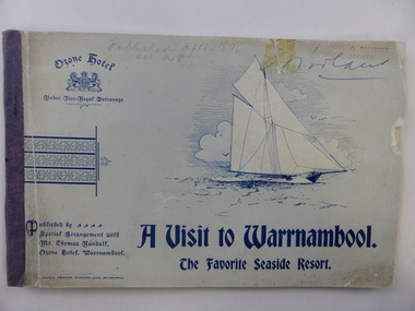
Book, The Ozone Hotel Warrnambool, Early 1900s
This booklet was produced for Thomas Randall, the proprietor of the Ozone Hotel, Warrnambool. The booklet has the front cover missing and the title of the booklet is actually ‘A Visit to Warrnambool’. It is a publicity booklet given out gratis to prospective clients of the hotel. The Ozone Hotel was originally called the Grand Ozone Coffee Palace and opened in 1890 as a temperance hotel, a splendid building with over 100 rooms. In December 1891 the Coffee Palace was granted a Colonial Wine Licence and in 1895 it was renamed the Ozone Hotel. Thomas Randall was the hotel keeper from 1894 to 1907. In 1920 the Ozone Hotel, after being closed for some time, was re-opened as the Hotel Mansions and a full liquor licence was obtained in 1923. In 1929 the building was burnt down and the present-day Hotel Warrnambool was built on the site. This booklet is of great significance as it documents the splendour of the Warrnambool Ozone Hotel when it was at its best. This building is regarded as the finest and most elegant building ever built in Warrnambool and this booklet contains the only photographs we have of the interior of a 19th century/early 20th century hotel in Warrnambool. This is a soft cover booklet publicizing the Ozone Hotel, Warrnambool, published for the proprietor Thomas Randall early in the 20th century. The front cover and several pages at the back are missing. The booklet contains advertisements, both local and Melbourne ones, black and white photographs of Warrnambool and district and of the interior and exterior of the Ozone Hotel, an article on the town of Warrnambool and extracts from the hotel’s Visitors’ Book. Most of the pages contain black and white ornamental motifs. One of the pages at the front of the booklet is torn in half. The booklet is bound with staples. On first page: Warrnambool & District Historical Society Stamp (smudged)grand ozone coffee palace/ozone hotel/hotel mansions, thomas randall, history of warrnambool -
 Warrnambool and District Historical Society Inc.
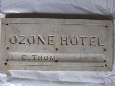
Plaque, Ozone Hotel, 1890
The building to which this tablet was attached was erected in 1890 as the Grand Ozone Coffee Palace. It was at the corner of Koroit and Kepler Streets in Warrnambool and was the most splendid edifice ever erected in Warrnambool. Initially it was a Temperance Hotel but in 1891 it gained a colonial wine licence. Thomas Randall was the lessee and proprietor of the building from 1894 to 1907 and from 1895 on it was called the Ozone Hotel. Mrs Lillias Euphemia Thom was the proprietor from 1907 to 1910. The tablet described herein has her name incised on the tablet ‘L.E.Thom’. The hotel was closed in 1915 and re-opened in 1920 with the new name of Hotel Mansions. The proprietor at that time was Howard Lawson. In 1923 Hotel Mansions gained a full hotel licence but in 1929 the building was destroyed by fire. The present day Hotel Warrnambool now occupies the site of the Hotel Mansions. This tablet is of great significance as it is an important memento of the Grand Ozone Coffee Palace/Ozone Hotel/Hotel Mansions. This building was the most elegant building ever to be erected in Warrnambool and, as such, a reminder of the type of luxury accommodation offered to visitors to Warrnambool in the late 19th and early 20th centuries. This was a time when Warrnambool was promoted as a spa resort with hot and cold sea baths and bracing sea breezes. The marble tablet is an indication of the splendor of the hotel’s furnishings and accoutrements. This is a rectangular marble slab with incised gold lettering (now somewhat faded). The bottom lettering is contained in a slight groove in the marble. There are four holes at each corner and six smaller holes along the edges of the tablet for attachment by screws to a building. The slab has some staining and a little rust. ‘Ozone Hotel’ ‘L.E.Thom’ grand ozone coffee palace (warrnambool), ozone hotel (warrnambool), hotel mansions, history of warrnambool, lillias thom -
 Federation University Historical Collection
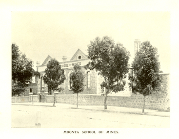
Book, Moonta School of Mines, Moonta School of Mines Annual Report, 1904, 1904
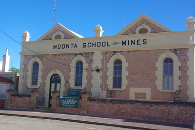
Opening in 1891 the Moonta School of Mines was intended for students who wanted to increase their knowledge of those arts and sciences which were especially important to miners and others similarly engaged. The School was situated close to the Moonta Mines, at that time the most important copper mines in Australia, and the smelters at Wallaroo. The the mines students were able to acquire practical knowledge of the work of a miner. The close by smelting works at Wallaroo were seen to be of great service to those wanting to become acquainted with chemistry and metallurgy. Subjects taught at the Moonta School of Mines included Chemistry, Metallurgy, Steam and the Steam Engine, Magnetism and Electricity, Mathematics, Machine Design, Mine Surveying and Leveling, Drawing, Plumbing and Sheet Metal Work. The Moonta School of Mines building in Ellen Street was formerly Baptist Church. Brown soft covered book of 87 pages. Contents include: * General objects of the School * Report for 1903 * Instructors Reports * Balance Sheet * Examination Questions * Timetable * Certificates granted by Council.cm Images include: * Moonta School of Mines * members of Council (Hancock, Symons, Uffindell, James, Hughes, Cowling, Haining) * Instructors (Rogers, Hancock, Pomroy, Blatchford, Martin, Richardson, Brown, Potter) * Classroom * Laboratory (Practical Chemistry) * Mine Surveying Classhancockmoonta, moonta school of mines, symons, uffindell, james, hughes, cowling, haining, rogers, hancock, pomroy, blatchford, martin, richardson, brown, potter, e.f. blatchford, a.l. brown, r. cowling, r. haining, h. lipson hancock, henry richard hancock, leigh g. hancock, j.w. hughes, t. james, edward martin, h. pomroy, f. potter, g.h richardson, g.j. rogers, j. symons, h.w. uffindell, schools of mines -
 Victorian Interpretive Projects Inc.
Photograph - colour, Clare Gervasoni, Moonta School of Mines, 25/06/2013
Opening in 1891 the Moonta School of Mines was intended for students who wanted to increase their knowledge of those arts and sciences which were especially important to miners and others similarly engaged. The School was situated close to the Moonta Mines, at that time the most important copper mines in Australia, and the smelters at Wallaroo. The the mines students were able to acquire practical knowledge of the work of a miner. The close by smelting works at Wallaroo were seen to be of great service to those wanting to become acquainted with chemistry and metallurgy. Subjects taught at the Moonta School of Mines included Chemistry, Metallurgy, Steam and the Steam Engine, Magnetism and Electricity, Mathematics, Machine Design, Mine Surveying and Leveling, Drawing, Plumbing and Sheet Metal Work. The Moonta School of Mines building in Ellen Street was formerly Baptist Church.Stone building used as the Moonta School of Mines. This image can be compared to a 1904 image at http://victoriancollections.net.au/items/519c24142162ef13f0648d42 moonta, school of mines, mining -
 Uniting Church Archives - Synod of Victoria
Photograph
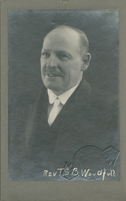
Rev. Thomas Staines Brittingham Woodfull (1863 - 1941). Born Maldon in 1863, but grew up in Prahran and attended the Punt Rd Church. Qualified as a pharmacist. Worked as a local preacher before being ordained in 1887. Appointed to Sandhurst in 1887 before being sent as Conference Evangelist to Tasmania, where he conducted missions. Married Gertrude Lily Abey (1872 - 1941) in 1891. Returned to Victoria in 1893 and served at Kerang, Maldon, Shepparton, Flemington & Essendon, Collingwood, Bendigo, Albert Park, Brunswick, Box Hill. Retired in 1930. Was active in the campaign against the Collingwood tote. President of the Methodist Conference 1923. Father of William (Bill) Woodfull, Australian cricketer of the 1920s and 1930s and Captain of the Australian First Eleven during the notorious "Bodyline" Test series.B & W waist length studio portrait of the Rev. T.S. B. Woodfull, mounted on grey card."Rev T.S B. Woodfull"thomas staines brittingham, gertrude lily abey, bill woodfull, president of conference, evangelist, methodist, minister, pharmacist. -
 Kew Historical Society Inc
Administrative record (item), Minute Book of the Kew Ladies Benevolent Society 1911-12, 1951-61
"This society was founded in 1891, when there was a considerable amount of distress on account of the collapse of the land boom. The first office-bearers were: President, Mrs. F. R. M. Wilson; Hon. Secretary, Mrs. S. Kellett; and Hon. Treasurer, Mrs. J. Lorimer. The society has had a useful career and been of great assistance to many families. One of its best workers was Mrs. G. Wharton. The present committee consists of Mrs. H. Collier (President), Mrs. Holdsworth (Vice-President), Mrs. Archer (Hon. Treasurer) Mrs. E. J. Dunn (Hon. Secretary), and Mesdames. Berry, Gillespie, Israel, Jellis, Kerr, Lilley, McCrea, Paton, Spring, Tappin, and Wishart." (Source: Barnard FGA, Jubilee History of Kew, 1910)The Kew Ladies' Benevolent Society was one of the most important women's groups in Victoria in the late 19th to mid-20th century. It was led by women with a national profile and was instrumental in the establishment of the State umbrella organisation. The Minute Book was presented to KHS by the Victorian Association of Benevolent Societies in 1991.Seller label on inside cover.kew ladies' benevolent society, social welfare - history - kew (vic), social services - history - kew (vic), volunteer organisations - kew (vic) -
 Kew Historical Society Inc
Accessory - Silk, Metal & Cane Parasol, c. 1899-1902
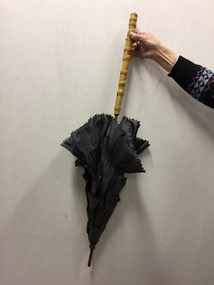
An item forming part of a collection of costumes, photographs and documents relating to the Weir family who owned and lived in the mansion originally named Illapa, 84 Princess Street, Kew, from 1918 to 1950. [The house is now incorporated by ‘Rylands’.] This historically significant collection includes items relating to both George Weir (1866-1937) and his wife Edith Mary Weir (1867-1948). George Weir, a person of national significance, was general manager of North Broken Hill Mine between 1903 and 1926. The collection includes a number of his patents. He married his wife, Edith Butteridge, in Broken Hill in 1891. The collection includes a number of costumes owned and worn by Edith, including her wedding dress. These costumes date from the 1880s to the 1940s and include items of outstanding aesthetic value.This parasol is significant as it is part of 26-piece collection of women’s clothing owned by Edith Mary Weir (nee Betteridge), who was born in Clare, South Australia in 1867 and who died in Kew at the age of 81 in 1948. The costumes in the donation date from the 1880s to the 1940s and constitute outstanding examples of dressmaker’s skills from each of these decades. The collection includes day dresses, evening dresses, evening coats, capes, a parasol, and undergarments. As the wife of a mining engineer, and later mine manager, Edith Weir’s clothing has historic significance as examples of clothing worn by upper middle class Australian women in domestic circumstances and at social and civic events. The costumes in the collection represent the periods when Edith Weir lived in Broken Hill, New South Wales, and in Kew, Melbourne. The garments in the Weir Collection were donated to the Kew Historical Society by the granddaughter of Edith Weir.Parasol - brown silk, pink lined with straight cane handle, owned by Edith Mary Weir (nee Betteridge) of Broken Hill, and later Princess Street, Kew. The style of the parasol, with overlapping outer 'scales' of heavy brown silk, would indicate that it was made in the late Victorian era.parasols, umbrellas, victorian fashion, weir collection -
 Kew Historical Society Inc
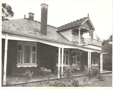
Photograph, Willsmere, circa 1965, c. 1965
The historian Dorothy Rogers records (A History of Kew, p.5) that "In 1888 he [Arthur Wills] took over his estate, 'Willsmere', and conducted it as a dairy farm. He was an architect by profession, and having established the farm he rented it, and returned to live in Barry Street, Kew, where his only child, Dorothy was born in 1889. He entered Kew Council in 1891, and three years later built a new house in Fellows Street, on land that Thomas had purchased at the 1846-47 sales. He became Mayor of Kew in 1896-97, and during his term of office sold this house and built the present 'Willsmere' [pictured] on the corner of Willsmere and Belford Roads. ... Never a house of great distinction, it has now been demolished to make way for a freeway."This work forms part of the collection assembled by the historian Dorothy Rogers, that was donated to the Kew Historical Society by her son John Rogers in 2015. The manuscripts, photographs, maps, and documents were sourced by her from both family and local collections or produced as references for her print publications. Many were directly used by Rogers in writing ‘Lovely Old Homes of Kew’ (1961) and 'A History of Kew' (1973), or the numerous articles on local history that she produced for suburban newspapers. Most of the photographs in the collection include detailed annotations in her hand. The Rogers Collection provides a comprehensive insight into the working habits of a historian in the 1960s and 1970s. Together it forms the largest privately-donated collection within the archives of the Kew Historical Society.Willsmere, the home of the Wills family of Kew, designed by the architect Arthur Wills, circa 1896. arthur wills, willsmere, belford road, willsmere road, dorothy rogers, kew, wills family -
 Kew Historical Society Inc
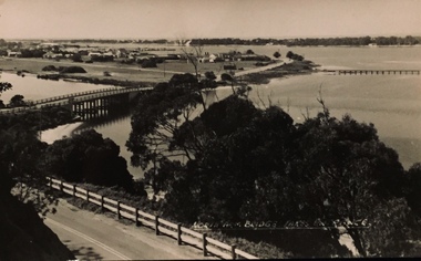
Photograph - North Arm Bridge, Lakes Entrance, Henry Beater Christian, 1920s
Henry Christian (c.1809-91) was one of the first settlers in Kew. He arrived in Victoria with his wife Agnes and son Orlando in 1855 on the Gypsy Queen. He established a rope-making business in Bulleen Road by 1858 but was declared insolvent two years later. In his final years, he was celebrated as one of the oldest living settlers of the district. His son, Orlando Henry Beater Christian (c.1853-1930) became a member of the Hawthorn Band and a foundation member of the Willsmere Swimming Club. Orlando and his wife Elizabeth had four children: Henry Beater (1886-1962), Ada Susannah May (1888-1962), Orlando Julius (1891-1917) and Lilian Adelaide ( -1956). Ada was to marry into the Washfold family. An item from an outstanding and diverse photographic collection, assembled by members of the Christian and Washfold families of Kew, comprising professional and amateur photography, depicting individuals, natural and settled environments and the interactions between these worlds. Photograph of Lake Arm Bridge at Lakes Entrance.Sent to Mavis and the boys [detailed text]landscape photography, lakes entrance (vic.), christian-washfold collection -
 Kew Historical Society Inc
Photograph - Yarra Valley Floods: Kew East, 1916
Flooding of the Yarra Valley, including that section of the Yarra bordering Kew and Kew East in the north and west of the municipality, was a regular occurrence. Extreme flood events of the Yarra River are recorded to have occurred in 1891, 1901, 1916, 1923 and 1934. The Municipality of Kew's response to these floods was to enact planning decisions restricting residential development in flood prone areas following the floods of 1916, 1921 and 1934. While floods continued after the development of the Upper Yarra Reservoir (construction 1948-57), the regularity and extent of these inundations diminished. During the nineteenth century, the land abutting the south side of the Yarra in Kew was devoted to dairy farming. In the twentieth century, before and after the construction of the Eastern Freeway, much of this low-lying area was used as golf courses and public parks.One of a collection of photographs of flooding in the Kew section of the Yarra Valley which are in important research resource for the location and extent of flooding in the first half of the twentieth century. Flooding of the Yarra Valley at East Kew in 1916. The view is taken from the intersection of Kilby Road with what is believed to be Birdwood Street, looking across the flood waters to Ivanhoe. The extensive flooded area shown in the photograph would have included the Kew Golf Club. Verso: "Floods along Kilby Road / near Birdwood St? & Kilby Road / 1917? / 87yarra river, yarra valley, floods -- kew, kilby road -- kew (vic.), kew golf club -
 Kew Historical Society Inc
Photograph - Yarra Valley Floods: Kew East, 1916
Flooding of the Yarra Valley, including that section of the Yarra bordering Kew and Kew East in the north and west of the municipality, was a regular occurrence. Extreme flood events of the Yarra River are recorded to have occurred in 1891, 1901, 1916, 1923 and 1934. The Municipality of Kew's response to these floods was to enact planning decisions restricting residential development in flood prone areas following the floods of 1916, 1921 and 1934. While floods continued after the development of the Upper Yarra Reservoir (construction 1948-57), the regularity and extent of these inundations diminished. During the nineteenth century, the land abutting the south side of the Yarra in Kew was devoted to dairy farming. In the twentieth century, before and after the construction of the Eastern Freeway, much of this low-lying area was used as golf courses and public parks.One of a collection of photographs of flooding in the Kew section of the Yarra Valley which are in important research resource for the location and extent of flooding in the first half of the twentieth century. Flooding of the Yarra Valley at East Kew in 1916. The view is taken from a street (maybe Birdwood Avenue) intersecting with Kilby Road looking northeast across the flood waters to Ivanhoe and Heidelberg. The extensive flooded area shown in the photograph would have included remnant dairy farms and the Kew Golf Club. Verso: "Floods / Yarra River / East Kew / Kilby Road / 1917? / 87"yarra river, yarra valley, floods -- kew, kilby road -- kew (vic.), kew golf club -
 Kew Historical Society Inc
Photograph - Flooding of the Yarra Valley at Kew East, 1974
Flooding of the Yarra Valley, including that section of the Yarra bordering Kew and Kew East in the north and west of the municipality, was a regular occurrence. Extreme flood events of the Yarra River are recorded to have occurred in 1891, 1901, 1916, 1923 and 1934. The Municipality of Kew's response to these floods was to enact planning decisions restricting residential development in flood prone areas following the floods of 1916, 1921 and 1934. While floods continued after the development of the Upper Yarra Reservoir (construction 1948-57), the regularity and extent of these inundations diminished. During the nineteenth century, the land abutting the south side of the Yarra in Kew was devoted to dairy farming. In the twentieth century, before and after the construction of the Eastern Freeway, much of this low-lying area was used as golf courses and public parks.Late example of the capacity of the Yarra Valley at Kew to flood, even though drainage works and the Upper Yarra Reservoir had reduced their regularity.Original black and white print photograph of the low-lying land at East Kew under floodwater on 16 May 1974. The vantage point of the photographer is Lister Street. In the photo, the fences of the Kilby Farm can be seen. Flooding was caused by overflowing water in Glass' Creek and the River Yarra. Annotation verso: "Hay's Paddock op No.30 Lister Street / 16 May 1974 11.50am / R.L. 46.04"hays paddock, floods, yarra river, glass' creek, lister street -
 Kew Historical Society Inc
Photograph - Flooding of the Yarra Valley at Kew East, 1974
Flooding of the Yarra Valley, including that section of the Yarra bordering Kew and Kew East in the north and west of the municipality, was a regular occurrence. Extreme flood events of the Yarra River are recorded to have occurred in 1891, 1901, 1916, 1923 and 1934. The Municipality of Kew's response to these floods was to enact planning decisions restricting residential development in flood prone areas following the floods of 1916, 1921 and 1934. While floods continued after the development of the Upper Yarra Reservoir (construction 1948-57), the regularity and extent of these inundations diminished. During the nineteenth century, the land abutting the south side of the Yarra in Kew was devoted to dairy farming. In the twentieth century, before and after the construction of the Eastern Freeway, much of this low-lying area was used as golf courses and public parks.Late example of the capacity of the Yarra Valley at Kew to flood, even though drainage works and the Upper Yarra Reservoir had reduced their regularity.Original black and white print photograph of the low-lying land at East Kew under floodwater on 16 May 1974. The vantage point of the photographer is Lister Street. Flooding was caused by overflowing water in Glass' Creek and the River Yarra. Annotation verso: "Lister Street looking north / Flood level / 16 May 1974 11.30am / R.L. 46.04"hays paddock, floods, yarra river, glass' creek, lister street -
 Kew Historical Society Inc
Photograph - Flooding of the Yarra Valley at Kew East, 1974
Flooding of the Yarra Valley, including that section of the Yarra bordering Kew and Kew East in the north and west of the municipality, was a regular occurrence. Extreme flood events of the Yarra River are recorded to have occurred in 1891, 1901, 1916, 1923 and 1934. The Municipality of Kew's response to these floods was to enact planning decisions restricting residential development in flood prone areas following the floods of 1916, 1921 and 1934. While floods continued after the development of the Upper Yarra Reservoir (construction 1948-57), the regularity and extent of these inundations diminished. During the nineteenth century, the land abutting the south side of the Yarra in Kew was devoted to dairy farming. In the twentieth century, before and after the construction of the Eastern Freeway, much of this low-lying area was used as golf courses and public parks.Late example of the capacity of the Yarra Valley at Kew to flood, even though drainage works and the Upper Yarra Reservoir had reduced their regularity.Original black and white print photograph of Hay's Paddock under floodwater on 16 May 1974. The vantage point of the photographer is Keystone Crescent looking east. Flooding was caused by overflowing water in Glass' Creek and the River Yarra. Annotation verso: "Keystone Cr looking east / 16 May 1974 11.50am"hays paddock, floods, yarra river, glass' creek -
 Kew Historical Society Inc
Photograph - Flooding of the Yarra Valley at Kew East, 1974
Flooding of the Yarra Valley, including that section of the Yarra bordering Kew and Kew East in the north and west of the municipality, was a regular occurrence. Extreme flood events of the Yarra River are recorded to have occurred in 1891, 1901, 1916, 1923 and 1934. The Municipality of Kew's response to these floods was to enact planning decisions restricting residential development in flood prone areas following the floods of 1916, 1921 and 1934. While floods continued after the development of the Upper Yarra Reservoir (construction 1948-57), the regularity and extent of these inundations diminished. During the nineteenth century, the land abutting the south side of the Yarra in Kew was devoted to dairy farming. In the twentieth century, before and after the construction of the Eastern Freeway, much of this low-lying area was used as golf courses and public parks.Late example of the capacity of the Yarra Valley at Kew to flood, even though drainage works and the Upper Yarra Reservoir had reduced their regularity.Original black and white print photograph of the low-lying land at East Kew under floodwater on 16 May 1974. The vantage point of the photographer is Lister Street. Flooding was caused by overflowing water in Glass' Creek and the River Yarra. Annotation verso: "Lister St looking same as No.3 / 16 May 1974 11.30"floods, yarra river, glass' creek, lister street -
 Kew Historical Society Inc
Photograph - Flooding of the Yarra Valley at Kew East, 1974
Flooding of the Yarra Valley, including that section of the Yarra bordering Kew and Kew East in the north and west of the municipality, was a regular occurrence. Extreme flood events of the Yarra River are recorded to have occurred in 1891, 1901, 1916, 1923 and 1934. The Municipality of Kew's response to these floods was to enact planning decisions restricting residential development in flood prone areas following the floods of 1916, 1921 and 1934. While floods continued after the development of the Upper Yarra Reservoir (construction 1948-57), the regularity and extent of these inundations diminished. During the nineteenth century, the land abutting the south side of the Yarra in Kew was devoted to dairy farming. In the twentieth century, before and after the construction of the Eastern Freeway, much of this low-lying area was used as golf courses and public parks.Late example of the capacity of the Yarra Valley at Kew to flood, even though drainage works and the Upper Yarra Reservoir had reduced their regularity.Original black and white print photograph of the low-lying land at East Kew under floodwater on 16 May 1974. The vantage point of the photographer is at Willsmere Road. The road itself is underwater.Annotation verso: "Willsmere Rd / Same as No.7 / 16 May 1974 11.15am"floods, yarra river, willsmere road -
 Kew Historical Society Inc
Photograph - Flooding of the Yarra Valley at Kew East, 1974
Flooding of the Yarra Valley, including that section of the Yarra bordering Kew and Kew East in the north and west of the municipality, was a regular occurrence. Extreme flood events of the Yarra River are recorded to have occurred in 1891, 1901, 1916, 1923 and 1934. The Municipality of Kew's response to these floods was to enact planning decisions restricting residential development in flood prone areas following the floods of 1916, 1921 and 1934. While floods continued after the development of the Upper Yarra Reservoir (construction 1948-57), the regularity and extent of these inundations diminished. During the nineteenth century, the land abutting the south side of the Yarra in Kew was devoted to dairy farming. In the twentieth century, before and after the construction of the Eastern Freeway, much of this low-lying area was used as golf courses and public parks.Late example of the capacity of the Yarra Valley at Kew to flood, even though drainage works and the Upper Yarra Reservoir had reduced their regularity.Original black and white print photograph of the low-lying land at East Kew under floodwater on 16 May 1974. The photograph is of Hyde Park looking north-east.Annotation verso: "Hyde Park looking nth-east / Flood Level / 16 May 1974 11.15am / R.L. 46.61"floods, yarra river, hyde park -
 Kew Historical Society Inc
Photograph - Flooding of the Yarra Valley at Kew, 1974
Flooding of the Yarra Valley, including that section of the Yarra bordering Kew and Kew East in the north and west of the municipality, was a regular occurrence. Extreme flood events of the Yarra River are recorded to have occurred in 1891, 1901, 1916, 1923 and 1934. The Municipality of Kew's response to these floods was to enact planning decisions restricting residential development in flood prone areas following the floods of 1916, 1921 and 1934. While floods continued after the development of the Upper Yarra Reservoir (construction 1948-57), the regularity and extent of these inundations diminished. During the nineteenth century, the land abutting the south side of the Yarra in Kew was devoted to dairy farming. In the twentieth century, before and after the construction of the Eastern Freeway, much of this low-lying area was used as golf courses and public parks.Late example of the capacity of the Yarra Valley at Kew to flood, even though drainage works and the Upper Yarra Reservoir had reduced their regularity.Original black and white print photograph of the low-lying land at East Kew under floodwater on 16 May 1974. The photograph is taken from 43 Kellett Grove.Annotation verso: "Kellett Gve No.43 / Flood Level / 16 May 1974 11.40am"floods, yarra river, kellett grove -
 Bendigo Military Museum
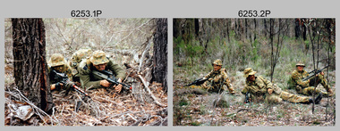
Photograph - Army Survey Regiment - Regimental Training Field Phase, 1995
This is a set of twenty photographs of the Army Survey Regiment undertaking regimental training in state forest north of Costerfield, Victoria, 1995. The state forest is now part of the Heathcote-Graytown National Park. The aim of the training was to provide personnel practical revision of infantry and minor tactics at the section level, navigation and map reading, RATEL and Survival in the Field. This was the Army Survey Regiment’s last military skills field training exercise before disbandment of RA Svy and the weather on the last day was wet and cold. It provided soldiers who decided to continue their military service essential military skills revision and for those who chose to discharge from the Army, it reinforced their decision to leave. LTCOL Duncan Burns was the last CO of the Army Survey Regiment from 1994 to 1996 and WO1 Ken Johnston OAM MM from RA Inf was the RSM for one year in 1995.This is a set of twenty photographs of the Army Survey Regiment undertaking regimental training in state forest north of Costerfield, Victoria, 1995. The photographs were printed on photographic paper and are part of the Army Survey Regiment’s Collection. The photographs were scanned at 300 dpi. .1) - Photo, colour, 1995, unidentified personnel. .2) - Photo, colour, 1995, L to R: Derek Percival, Damien Cole, unidentified. .3) - Photo, colour, 1995, L to R: unidentified, Chris ‘Charlie’ Brown, unidentified (x2). .4) - Photo, colour, 1995, unidentified personnel. .5) - Photo, colour, 1995, unidentified. .6) - Photo, colour, 1995, unidentified personnel. .7) - Photo, colour, 1995, unidentified personnel. .8) - Photo, colour, 1995, L to R: Jim Ash, Syd Anstee, unidentified, Rob Bogumil. .9) & 10) - Photo, colour, 1995, L to R: Steve Hill OAM CSM, Rob Bogumil, Brian Paul, Jim Ash, Syd Anstee, Colin Davidson. .11) - Photo, colour, 1995, L to R: Paul ‘Hutch’ Hunter, Stu Ridge, Chris ‘Charlie’ Brown. .12) - Photo, colour, 1995, RSM WO1 Ken Johnston OAM MM. .13) - Photo, colour, 1995, Peter Imeson. .14) - Photo, colour, 1995, L to R: Stu Ridge, Alan Virtue. .15) - Photo, colour, 1995, CO LTCOL Duncan Burns. .16) - Photo, colour, 1995, unidentified personnel. .17) - Photo, colour, 1995, L to R: Tony Harder, CAPT Sutiman (Indonesian Exchange Officer), Kasey ‘Tiges’ Northausen, unidentified (x2), Mick Duggan. .18) - Photo, colour, 1995, CAPT Sutiman (Indonesian Exchange Officer). .19) & 20) - Photo, colour, 1995, unidentified personnel..1P to .20P – No personnel are identified.royal australian survey corps, rasvy, army survey regiment, army svy regt, fortuna, asr -
 Ballarat Clarendon College
Book, Keegan Paul, Trench, & Co, The study of sociology, 1888
This book was awarded to Ewen Wanliss in 1892 for first prize for Mathematics & Classics in the Upper Sixth form. Ewen enrolled at Ballarat College in 1888 at the age of 15 along with his brothers David, Cecil, Newton, Sydney and Neville. Ewen's father was Hon. T. D. Wanliss and his previous school was Toorak College IV class. The Wanliss family grew up in Wanliss House Sturt St, which was bought by the school in 1910. The house remained on the property until 1996. "Ewen Wanliss was born on 24th September 1873 and died in 1966. He was educated at Ballarat College, enrolled in1888, and was Captain of the College 1st XI and 1st XVIII in 1892. He served as 327 Pte E Wanliss, 4th (Imperial) Contingent, and as a Lieutenant (20th August 1900) with the 4th Imperial Bushmen in the South African War." (In the footsteps of Pompey p. 14).Presbyterian educators placed great value on a classical education matched with diligence in study. Book prizes were highly regarded and academic success admired. In the school’s early years prizes were ordered direct from London and had the school crest embossed in gold on the front or back cover. Many of the prizes given in early years were returned to the school to equip the Weatherly Library when it opened in 1936.Bound in dark green calf with College emblem embossed on front cover and six raised bands on spine. The second band gilt inscribed and the remaining bands with gilt decoration. Marble end papers and edges. Foxing on pages, front cover detached, 446 p.Book plate inside front cover: Ballarat College emblem/ Mathematics & Classics/ Upper Sixth Form./ First Prize./ Awarded to/ E. Wanliss/ Christmas, 1892. ewen-wanliss, 1892, book-prize, ballarat-college, david, cecil, newton, sydney, neville, hon-t-d-wanliss, toorak-college, wanliss-house-sturt-st, south-african-war. -
 Federation University Historical Collection
Article - Article - Women, Ballarat School of Mines to University of Ballarat: Women of Note; Verna Barry, Secretary to Jack Barker
Verna Barry commenced worked as a typist at the Ballarat School of Mines (SMB) in 1961. In 1965 she became private secretary to Jack Barker, Principal of the Ballarat School of Mines and later Director of the Ballarat Institute of Education (BIAE) and the Ballarat College of Advanced Education (BCAE). A trusted and loyal member of staff, Verna was devoted to her job, her workplace and greatly respected Jack Barker with whom she worked loyally for until his retirement in 1987. In 1988 Verna was appointed Administration Officer with Engineering Faculty. She spent five years with Engineering Science from 1990, and in 1996 worked for Information Technology & Mathematical Science (ITMS), becoming a key member of the Research Support team. After thirty-nine years of service to the University of Ballarat and its predecessor institutions Verna Barry retired from full-time work on 31 January 2000women of note, verna barry, typist, secretary, jack barker, 1965-1987, ballarat school of mines, ballarat institute of advanced education, ballarat college of advanced education, administration officer, engineering faculty, engineering science, information technology and mathematical science, research support -
 Orbost & District Historical Society
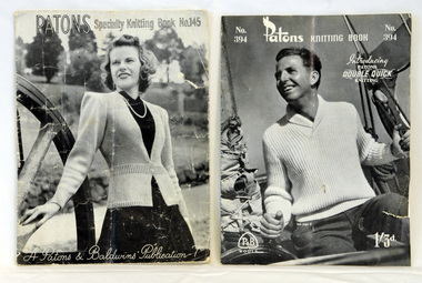
pattern books, Patons Specialty Knitting Book, 1940-1950
These knitting pattern leaflets were published by Patons and Baldwins and contain knitting patterns for women's and men's garments. Patons & Baldwin began as two separate companies: J & J Baldwin and Partners, founded in the late 1770s by James Baldwin of Halifax, West Yorkshire, England, and John Paton Son and Co., founded in 1814 by John Paton of Alloa, Scotland. Both men had formed their businesses using the spinning mule developed by Samuel Crompton. They mainly produced yarns for commercial knitting machines. Patons established itself in Australia with its first mill built in Tasmania in 1923. For decades, Patons was the leading hand knitting yarn brand but due to the market conditions in the mid 1980's, Patons felt the decline and eventually amalgamated with Alliance Textiles, New Zealand in 1996. Patons Australia was acquired by Australian Country Spinners in 2000. Knitting has always had a great appeal to women, as it needs few tools. Companies which manufactured yarn often produced instruction guides and patterns. These pattern books are typical of the knitting pattern books commonly used in the mid 20th century. The patterns contained are for garments commonly worn at that time.Two knitting pattern books. Both are black / white and contain knitting patterns. 821.1 cost 7d, is titled "Patons Specialty Knitting Book No. 145" and has on the front cover a lady standing near a buggy wheel. 821.2 cost 1/3, is titled " Patons Knitting Book No. 394 (introducing Patons Double Quick Knitting)" and has has on the front cover a photograph of a man on a boat.knitting-patterns needlecraft patons-baldwin -
 Orbost & District Historical Society
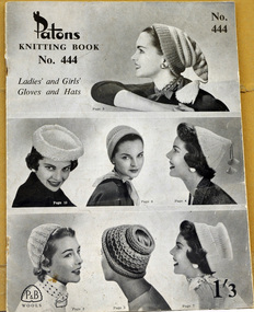
pattern book, Patons Knitting Book, mid 20th century
This knitting pattern leaflet was published by Patons and Baldwins and contains knitting patterns for women's garments. Patons & Baldwin began as two separate companies: J & J Baldwin and Partners, founded in the late 1770s by James Baldwin of Halifax, West Yorkshire, England, and John Paton Son and Co., founded in 1814 by John Paton of Alloa, Scotland. Both men had formed their businesses using the spinning mule developed by Samuel Crompton. They mainly produced yarns for commercial knitting machines. Patons established itself in Australia with its first mill built in Tasmania in 1923. For decades, Patons was the leading hand knitting yarn brand but due to the market conditions in the mid 1980's, Patons felt the decline and eventually amalgamated with Alliance Textiles, New Zealand in 1996. Patons Australia was acquired by Australian Country Spinners in 2000.Knitting has always had a great appeal to women, as it needs few tools. Companies which manufactured yarn often produced instruction guides and patterns. This pattern book is typical of the knitting pattern books commonly used in the mid 20th century. The patterns contained are for garments worn at that time.A seven page stapled booklet of knitting patterns. It is titled Patons Knitting Book No. 444, Ladies' and Girls' Gloves and Hats. It has a price 1/3.On the front cover are photos of the garments for which the patterns are provided.knitting handicrafts patons-and-baldwins -
 Federation University Historical Collection
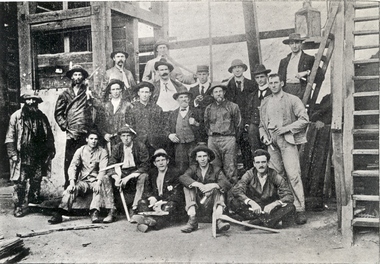
Photograph (black & white), Ballarat School of Mines Students visit the New Normanby Mine, 1899, 1899
In 1875 John Rowe enrolled at the Ballarat School of Mines (SMB) where he studied Metallurgy and Assaying. In 1880 the Britannia Mine closed and John Rowe moved to Launceston working as Manager of the Royal Tasman Gold Mining Company. He returned to Ballarat two years later to manage the Long Gully United Gold Mining Company. In 1885 John Rowe sought work in New Caledonia followed by South Africa. While in South Africa he received an offer from SMB to lecture in Practical Mining, an instructional innovation which involved weekly visits to some of the principle mines in the district. John Rowe took up this position in 1994, but it appears to have been a short lived innovation ending in 1996, possibly due to John Rowe's failing health. (http://guerin.ballarat.edu.au/curator/honour-roll/honourroll_Rowe,John.shtml)Nineteen men, some Ballarat School of Mines students, pose outside Ballarat's New Normanby Mine. Some hold picks and candles. The man in the centre wearing a waistcoat is John Rowe, experienced miner and lecturer in Practical Mining at the Ballarat School of Mines. The June 1899 Ballarat School of Mines Magazine records: "The mining class visited the Britannia Gold Mine, and were kindly shown over the surface and underground workings by Mr. Harvey."candle, ballarat school of mines, safety cage, john rowe, new normanby gold mine, mining alumni, pick -
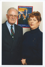 Melbourne Legacy
Photograph, Denise gives it back. Best chance in life, 2000
A 2 page double spread feature in the Herald Sun on 29th August 2000 to promote Legacy prior to Legacy Week. The photo of Legatees Rob Allison and Denise Milic is accompanied by the article 'Denise gives it back'. Denise was helped by Legacy when her father, who had served in World War 2, died when she was 12. Denise now joined Legacy to help the older Legatees who have had to slow down their involvement. Until 1996 Legatees were people who had served in the forces. Then it was extended to include Junior Legatees who were the children of servicemen who had died. Rob Allison had been a Legatee for 50 years. The other article was about the types of service Legacy provided for widows and children and included a photo of junior legatees rock climbing on an outing. A story on how a child helped by Legacy has joined as a Legatee. Also a story on the types of services provided by Legacy to children and widows.Colour photo x 2 of two Legatees and a newspaper article about them.Photocopy of a newspaper articles are titled 'Denise gives it back' and 'Best chance in life'.legacy promotion, legacy week -
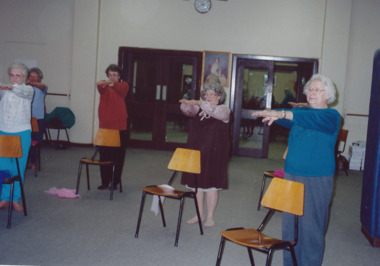 Melbourne Legacy
Photograph - Exercise Classes, Widows activities, 1991
A group of widows at Legacy House doing seated exercises in June 1991, being taught by instructor Betty Luders who ran the classes for many years (at least from 1996 to 2001). Similar to photos 01544, plus 00619 and 00620 which show exercise classes in 2004. Melbourne Legacy ran an excellent exercise program for its widows for many years at Legacy House. Photos were in a scrapbook of photos spanning 1983 to 1991, they were taken by Susie Howard, Publicity Officer. The labels with the photos explain: ' Exercise - You can do it Legacy . . . organise many activities for their widows. Helping them to keep fit is high on the list of priorities. Instructor Betty Luders keeps a watchful eye on proceedings and ensure the classes are enjoyable as well as beneficial. Many of the health problems associated with old age can be be prevented for managed with the help of regular exercise.'A record of the types of activities Legacy provided as a physical and social outlet for widows. Colour photo x 5 of Legacy widows doing exercises at Legacy House.Handwritten white paper label in blue pen 'June '91'. widows, exercise classes, activities, betty luders -
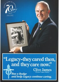 Melbourne Legacy
Poster, Legacy - they cared then, and they care now. Clive James (Former Junior Legatee), 1993
This is an example of Melbourne Legacy promotional material. Clive James was Personality of the Year in 1993, which was the 70th anniversary of Legacy. The logo said "Seventy years of constant caring 1923-1993". Clive had been a junior legatee as a boy. This A4 page could be used as a poster to promote badge week. The main time of year for fundraising is September when Legacy holds 'Badge Week'. Often there is a celebrity who gives his or her time as 'Personality of the Year'. Examples are Sir Weary Dunlop (1992), Clive James (1993), the Scott family (1994), The Emmanuel brothers (1995), Daryl Somers (1996 and 1997), and Patsy Adam Smith (1994?). Was in a folder with marketing material from the 1990s to 2009, see items 01240 to 01258. The collection shows the types of marketing materials that were produced and the celebrities that were helping Legacy.An example of promotional material from the 1990s. Marketing material and photos were compiled and released to newspapers, also printed as brochures and sometimes as stickers and collection tin wrappers.Colour A4 promotional leaflet with a photo of Clive James.legacy promotion, legacy week, 70th anniversary, clive james