Showing 22292 items
matching parks
-
 St Kilda Historical Society
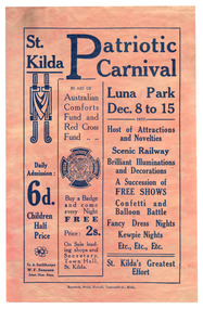
Ephemera - Flyer, St Kilda Patriotic Carnival Luna Park, 1917
For St Kilda Patriotic Carnival at Luna Park to aid Australian Comforts Fund and Red Cross FundPink/discoloured or buff paper, printed one side in bluewwi fund-raising, luna park, st kilda carnivals, australian comforts fund, victorian red cross -
 St Kilda Historical Society
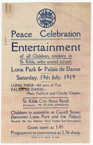
Ephemera - Flyer, Peace Celebration Entertainment, 1919
Peace celebration entertainment for St Kilda children at Luna Park and the Palais de Danse, St KildaSingle sheet of white paper that has discoloured with age, printed in blueluna park, palais de danse, city of st kilda, wwi peace celebrations, st kilda brass band -
 Tatura Irrigation & Wartime Camps Museum
Book, War Trophies, 1999
Photographs of large collection of WW1 guns now in parks all over Australia. Includes stories of battles.Blue cover. Dust cover. Photo of soldiers loading heavy British gun. On back cover - German 150 mm Howitzer. Now at Warracknabeal, Vic. 1914-1918 Warwar trophies, first world war, tatura -
 Tatura Irrigation & Wartime Camps Museum
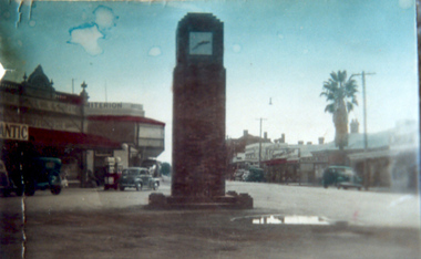
Photograph, Dr. Park Memorial Clock Tower
Hogan Street c.1950, with Dr. Park Memorial Clock Tower & other buildings (2 copies) -
 Stawell Historical Society Inc
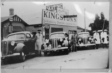
Photograph, Mr F C Kingston's Taxi in Stawell parked in front of Centenary Hall on the corner of Wimmera & Child Street 1935-1940
Taxis of F.C. Kingston 1935-40 parked in front of Centenary Hall Wimmera Street and Child Streetstawell transport -
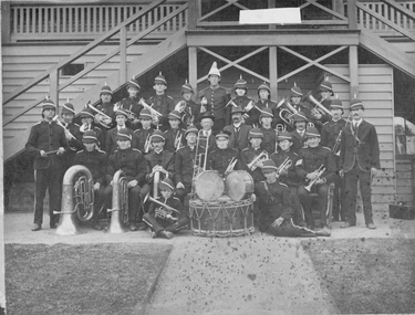 Stawell Historical Society Inc
Photograph, Stawell Brass Band 1900's
Photo taken in front of No1 Grandstand Central Park. Words Stawell Brass Band visible on drum band, entertainment -
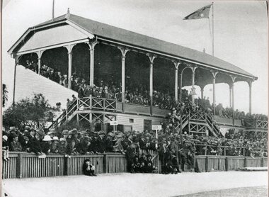 Stawell Historical Society Inc
Photograph, No1 Grandstand Central Park taken from the Souvenir of the Diamond Jubilee of the Borough of Stawell 1869-1929
No1 Grandstand Central Park taken from the Souvenir of the Diamond Jubilee of the Borough of Stawell 1869-1929stawell sport -
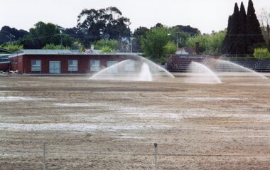 Stawell Historical Society Inc
Photograph, Central Park Stawell during renovation and extension of the oval -- Coloured
One of three photographs of Central park Stawell during renovation and extension of the oval. Showing Hall and Sprinklersport -
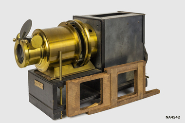 Whitehorse Historical Society Inc.
Equipment - Projector, C1920
Owned by Newspaper photographer living in Wattle Park c 1960s.Possibly Nepera Brand, Name on Slide Boxes.1.A Wooden Case with a Sliding Rear Door for Projector. 2. Projector, Wood & Brass, Black Metal Box at rear for lamp & electric lead, spare lens inside. Brass lens holder & Focus adjuster at other end. 3. Wooden slide holder holds two slides, and fits between body and lens tube. 4. Spare lens marked 6 In EQUI with sliding collar. 5. 3 packs of glass slides. 4. Grey tin containing slides. Slides stored in .09.13.No 510324 on Lens Adjuster Ron.230577, 7in, Est 1816, Trade mark. London Made. Without name Australasia Pty Limited.photography, photographs / slides / film, projectors -
 Whitehorse Historical Society Inc.
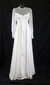
Clothing - Wedding Dress, 1978 c.February
Made for and worn by Jeanette Margaret Bennett at her wedding at Uniting Church, Riversdale Road, Wattle ParkWhite chiffon 1978 round neck line dress with high waist, long sleeves; with cuff and six covered buttons. Hem line and neck trimmed with satin. Dress lined with satin underskirt. See also 3597., Wedding Veilcostume, female ceremonial -
 Whitehorse Historical Society Inc.
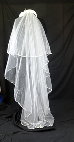
Clothing - Wedding headdress & veil, 1978
Made for and worn by Jeanette Margaret Bennett for her wedding at Uniting Church, Riversdale Road, Wattle ParkWide, white 1978 headband padded and covered with nylon net, and decorated with satin flowers. Veil trimmed with 4 cm wide satin ribbon|NA3596 wedding dresscostume, female headwear, female ceremonial -
 Whitehorse Historical Society Inc.
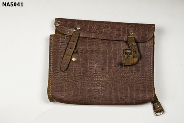
Equipment - School satchel
School satchel used by donor's son in the late 1960s and early 1970s at Antonio Park State SchoolUsed to carry books, pencils etcSchool Satchel with a carry strap & 1 buckle made of patterned brown leatherScott Gardiner -
 Rutherglen Historical Society
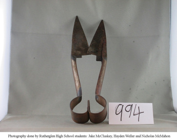
Tool - Shears
Donated by Mrs A Terrill, the shears once belonged to Mr D A Terrill of "Thornbury Park" Via RutherglenHand shears used for shearing sheep"Made in England. Combination UTS No. 1 Sheffield" -
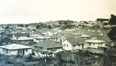 City of Ballarat Libraries
Photograph - Card Box Photographs, View of Sovereign Hill before the development of the historical village circa 1960
Shows a south west view towards Sovereign Hill before the establishment of the Ballarat Historical Park Association.sovereign hill, private dwellings, landscape, ballarat, mt pleasant -
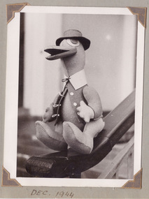 Department of Health and Human Services
Photograph, Taken of a toy duck which was made in workshops that were established to assist rehabilitating tuberculosis patients at Gresswell Sanitorium, in 1944, 1944
From an album of photographs taken at Gresswell Sanatorium at Mont Park. https://www.findingrecords.dhhs.vic.gov.au/collectionresultspage/Gresswell-SanatoriumPhotograph from a 26 leaf photograph album. tuberculosis, sanatorium -
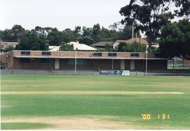 Stawell Historical Society Inc
Photograph, Stawell Football Club Rooms at North Park -- old being demolished & new ones under construction 1991 & 2000 -- 15 Colour Photos
Club Rooms North Park 1991 & 2000 Demolition of old rooms and photos of erection of brick rooms.15 Colour photographs of building being demolished and erected,stawell -
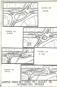 Wonga Park Community Cottage History Group
Work on paper (Item) - Plan, Wonga Park: Four Options for development of Jumping Creek, Yarra and Dudley Roads corner c. 1983
Prepared by the Shire of Lillydale during discussion with Wonga Park & District Residents' Association regarding the redevelopment of the intersection -
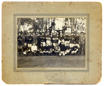 Tarnagulla History Archive
Football players in Tarnagulla, 1913
Murray Comrie Collection. This photo was probably taken at either Victoria Park or the Recreation Reserve in Tarnagulla, Victoria.Group of men and boys, some in football attire posed as a group in an outdoor area with gum trees behind them. Three boys are standing in/on trees at rear. Main in suit at far right. Handwritten on reverse are names of some subjects, the name 'L.Williams', the name and address 'J. Sheldon, 1 Francis Grove Thornbury' and the phrase 'Tarnagulla near Bendigo'. '1913 Wednesday' handwritten on front.tarnagulla, sport, football, radnell family, smith family, burstall family, bert family, whimpey family, shelton family, robinson family, chapman family, birchall family, ousley family, harwood family, ison family, kilgower family, bock family, norwood family, rivvett family, abbot family -
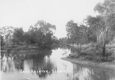 Stawell Historical Society Inc
Photograph, Lake Reserve in Stawell
Lake Reserve Stawell. View of lake surrounded by trees. Now called The Grampian Gate Caravan Park.Black and white photograph of lake with trees around.Lake Reserve. Stawell. stawell -
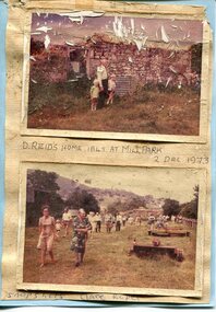 Kiewa Valley Historical Society
Photographs x 2- D Reids home at Mill Park 1973, 2/12/1973
David Reid (1820-1906) was a pastoralists and politician. He left school at 16 and after meeting the overlander John Gardiner he decided to look for land south of the Murray River. Equipped by his father with some 500 head of cattle, 2 bullock wagons and teams and 6 assigned servants, he reached the Ovens River on 8 September 1838. David settled at Currargarmonge, near Wangaratta. At the end of 1843 he took up land near Yackandandah. In 1847 he took up a section of the family run of which Woorajay (Wooragee) formed a part. He built the first water driven flour-mill in the district on his Yackandandah run in 1845; his woolclip of 1848 was one of the first to be handled by R. Goldsbrough and was claimed to come from sheep descended from stock imported in the 1820s from George III's flock. Going into politics, he held the Legislative Assembly seat of Murray from October 1859 to May 1862. David Reid was a highly regarded grazier and local politician who was significantly involved in settlement around the Yackandandah area. Photo demonstrates ongoing interest in the local history of the area and its early residents2 colour photographs mounted together on buff card 1. Man and 2 children (unidentified) standing outside the remains of the Reid home. 2 Dec, 1973 2. Group of unidentified people on a tour of the old homestead of D. Reid. 2 Dec, 19731. Handwritten in black ink under photo 'D. Reid's home 1845. At Mill Park. 2 Dec 1973 2. Handwritten in blue ink under photo 'Snapshots Clare Roper"clare roper -
 Orbost & District Historical Society
black and white photographs, January 1934
These are photographs taken during the 1934 flood at Orbost. From The Argus (Melbourne) on January 10 1934 "Damage estimated at £500,000 has been caused by the floods in the Orbost district. No loss of life occurred, largely owing to the heroic efforts of rescue parties. Many families spent Monday night on the roofs of houses or in trees, surrounded by deep, rushing flood waters." This 1934 flood was devastating, destroying a section of the 1922 Orbost bridge - the centre span was washed away -. wrecking fences, bridges and roads, dumping silt and debris on the rich river flats and drowning cattle.These photographs are pictorial records of the 1934 floods at Orbost, a significant event in the history of Orbost.Nine small black / white photographs of flood damage,3253.2 on back - "Waters rushing down Princes Highway and....of......where you see the waves" 3253.3 on back - "rushing flood waters over Lochiel Park Bridge approach at the rear of picture 1934"orbost-flood-1934 flood-orbost -
 Ringwood and District Historical Society
Letter, Ringwood Bowling Club asking the council for further support to provide shrubs and flowers for Bamford Park and the bowling green area in 1931
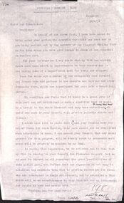
1929 saw the establishment of the Ringwood Bowls Club initially located on the land now occupied by the Eastland Shopping Centre. It moved to its current location in Loughnan Road, Ringwood in 1997.Ringwood Bowling Club asking the council for further support to provide shrubs and flowers for Bamford Park and the bowling green area in 1931. Also letter of thanks for 12 pounds, six weeks later.city of ringwood bowls club, ringwood bowling club, ringwood bowls club, lawn bowls, bowling -
 Ringwood and District Historical Society
Newspaper, Scrapbook Clipping, Library Collection, Ringwood, Victoria, `
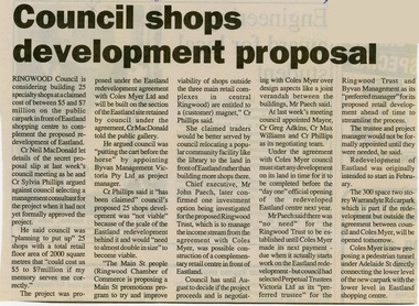
``Newspaper clipping from "The Post", 24-3-93, P3. Council shops development proposal Ringwood Council is considering building 25 specialty shops at a claimed cost of between $5 and $7 million on the public car park in front of Eastland shopping centre to cpmplement the proposed redevelopment of Eastland.` -
 Stawell Historical Society Inc
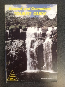
Book, Stawell & Grampians Tourist Council, Stawell and Grampians Tourist Guide 10th Edition, 1968
Stawell Tourist Information.Card cover Showing Photograph of a Waterfall. Yellow Print across top. Yellow triangle enclosing Yellow Print, Bottom Right, White Text bottom Left.Across the Top, "Stawell and Grampians TOURIST GUIDE". Bottom Right a Yellow Triangle Enclosing the text "10th Edition $2.50" Rear Cover conatins advert for Stawell World in Miniature Tourist Parkstawell tourism -
 Darebin Parklands Association
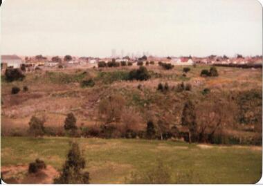
Alphington c1982, Darebin Parklands Association, 1980 - 1983
Colour photograph. This item and all other Darebin Parklands Association archival material is now held by State Library Victoria (Accession No: YMS 13746). Please contact State Library Victoria if access is required.Annotated on back [View of Alphington side of park circa 1981-2 ? Taken from top of Rangers Hut.] Found in folder titled:[Darebin Parklands 1982 Australia 4/10/82]. -
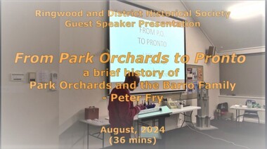 Ringwood and District Historical Society
Mixed media - Video, RDHS Guest Speaker Presentation - "Barro Family Park Orchards to Pronto" - Peter Fry
Digitised video (1.63GB). Duration: 36 minutes. Recorded August, 2024. (Video is available for viewing at Ringwood & District Historical Society Archives by appointment)In this presentation, long time RDHS member and Treasurer, Peter Fry, provides this month's informative talk on a brief history of the neighbouring hamlet of Park Orchards, and the Barro Family's association with Ringwood and Pronto Concrete. -
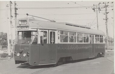 Melbourne Tram Museum
Photograph - Set of 7 Colour Print/s, Melbourne & Metropolitan Tramways Board (MMTB), c1973
Set of seven black and white prints of prototype tram 1041, during its first days of commissioning and testing in the city and on the Wattle Park route. All printed on Kodak paper. .1 - at Preston workshops, showing City, route 088 .2 - ditto .3 - ditto - 2nd copy added from donation of Geoff Warburton added 10/10/17. .4 - In Riversdale Road, Wattle Park, showing W. Park Elgar Rd, route 070. .5 - ditto, but showing special and route 000 - trees behind the tram had been faded out. .6 - turning out of Bourke St into Spring St with destination of E. Brunswick, route 96. Has been painted with words "Welcome Board" and "Enter here" on front door. Has the Windsor hotel in the background. Second trolley retriever fitted as well. .7 as for .5 but at a different location. 2nd copy of .3 added 10/10/17.4 - notes to remove pole, ext and I HT and grating on rear along with a sketch of the tram outline and number 16. .6 - on rear "9 3/4 x 6 1/8" .7 on front of the photo "9 3/4" x 6 1/4" in felt pen. .3 - second copy "1041-Preston-3-MMTB" in pencil on rear.trams, tramways, mmtb, prototype tramcar, 1041, riversdale rd, wattle park, preston workshops, tram 1041 -
 Eltham District Historical Society Inc
Photograph - Digital Photograph, Alan King, Alistair Knox Park, Eltham, 2008
Alistair Knox Park, an oasis of peace and beauty. Covered under National Trust of Australia (Victoria) Landscape Significance and Heritage Overlay, Nillumbik Planning Scheme. Published: Nillumbik Now and Then / Marguerite Marshall 2008; photographs Alan King with Marguerite Marshall.; p173 It is hard to imagine that the Alistair Knox Park, an oasis of peace and beauty beside busy Main Road, Eltham, was once the township’s rubbish dump. It was only in the 1970s that the tip was transformed into this beautiful six hectare space, which later earned it a National Trust Landscape classification. Before its life as a dump, the area was used for small farms. Thanks largely to the foresight and efforts of local environmental builder Alistair Knox, the park was designed sympathetically with the character of the wider Eltham landscape. Then, appropriately, the park was named after Knox, who was an Eltham Shire Councillor from 1971 to 1975 and Shire President in 1975. The park designers were four major forces in the urban bush landscape garden –Knox, landscape designer Gordon Ford, artist Peter Glass and landscaper Ivan Stranger. The National Trust citation for the park, originally called Eltham Town Park, includes the Eltham railway trestle bridge and the Shillinglaw Cottage. The citation states ‘the semi-natural setting of the parkland provides a landscape which is evocative of the history of the area’. Manna Gums (Eucalyptus viminalis) and Candlebarks (Eucalyptus rubida) are significant features. Most of the park’s construction was directed by Bob Grant, Superintendent of the Parks and Gardens Department for the Eltham Shire Council. First plantings occurred in Arbour Week in 1973, then the lake and botanic area were completed in 1975, with Federal Government funding, and the toilet block in 1978. Bounded by the Eltham railway line, Panther Place, Main Road, Bridge and Susan Streets, the park is in a valley about a kilometre wide overlooked by steep hills at the east and west. The Diamond Creek flows through it and the picturesque historic timber trestle railway bridge edges the north. Informal plantings of Australian indigenous and native species in open and undulating grassed settings blend with the natural landscape of the Diamond Creek to the west. The bush-style plants, particularly around the creek, balance with open lawns, paths and a cascade flowing from a small lake to another below. A footbridge over the creek leads to the park’s west. The park includes an adventure playground and barbecue areas. The park stands on part of the land bought from the Crown in 1851 by Josiah Holloway, who subdivided it into allotments and which he called Little Eltham. Most of the land was subdivided into residential lots, but the creek valley, on which the park stands, was subdivided into farm-size lots, used mainly for orchards and grazing. One of the earliest owners was John Hicks Petty, who in 1874 bought a plot from Holloway. Other families who owned properties in that area, included Rees, Clark, Waterfall, Graham, Hill and Morant. In 1901 the railway was built through the area. Jock Read, an Eltham resident since around 1920, remembers several farms in the 1920s and ’30s that occupied the site of today’s park. A poultry farm, which extended from present day Panther Place, was owned by the Gahan family. Next to that farm was another for grazing cattle owned by Jack Carrucan. Beside this was land owned by John Lyon. A doctor lived beside this, and at the north-west corner of Bridge Street and Main Road stood a memorial to the soldiers who died in World War One, which was later moved to the RSL site. Mr Read also remembers other farms and orchards west of the creek In the early 1960s the Eltham Council began buying these farms and in the late 1960s turned the areas east of the Diamond Creek into a garbage tip. When this was filled above the creek’s flood plain, the tip was moved to the west of the creek.This collection of almost 130 photos about places and people within the Shire of Nillumbik, an urban and rural municipality in Melbourne's north, contributes to an understanding of the history of the Shire. Published in 2008 immediately prior to the Black Saturday bushfires of February 7, 2009, it documents sites that were impacted, and in some cases destroyed by the fires. It includes photographs taken especially for the publication, creating a unique time capsule representing the Shire in the early 21st century. It remains the most recent comprehenesive publication devoted to the Shire's history connecting local residents to the past. nillumbik now and then (marshall-king) collection, alistair knox park, eltham -
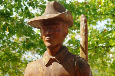 Greensborough Historical Society
Photograph - Photograph - Digital Image, Marilyn Smith, Digger Three by Leigh Conkie, 18/03/2014
Digger Three. This chainsaw sculpture is one of a series of chainsaw sculptures in Greensborough War Memorial Park, sculpted by Leigh Conkie in 2003. The trees surrounding the park were removed when disease made them unsafe, and the sculptures were created from the stumps. These original sculptures were removed in 2017 and replaced with a new series of chainsaw sculptures called Homefront.A tribute to locals who served in the armed forces for Australia.2 Colour digital photographs.greensborough war memorial park, leigh conkie, chainsaw sculptures, war memorials greensborough -
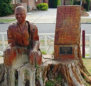 Greensborough Historical Society
Photograph - Photograph - Digital Image, Marilyn Smith, The grandfather that never was by Leigh Conkie, 18/03/2014
The grandfather that never was. This chainsaw sculpture is one of a series of chainsaw sculptures in Greensborough War Memorial Park, sculpted by Leigh Conkie in 2003. The trees surrounding the park were removed when disease made them unsafe, and the sculptures were created from the stumps. These original sculptures were removed in 2017 and replaced with a new series of chainsaw sculptures called Homefront.A tribute to locals who served in the armed forces for Australia.2 Colour digital photographs.greensborough war memorial park, leigh conkie, chainsaw sculptures, war memorials greensborough