Showing 5245 items
matching view road
-
 Cobram Historical Society Inc
Camera, Kodak
The Kodak Brownie Flash II Camera, English model camera was made 1957-1960Kodak, box brownie camera with a leatherette covering with a horizontally striped front panel lens and view finder at front, film winder at side, clip door at back for film loading. Leather strap on top, attached one side, broken at the other. Kodak Brownie Flash II Camera, Made in England by Kodak limited London. -
 Lake Bolac & District Historical Society
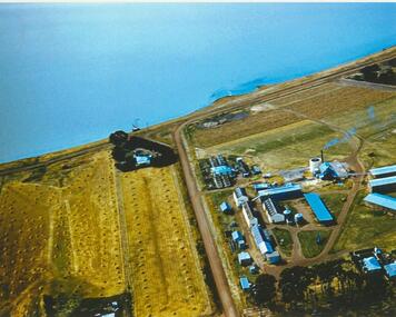
Colour photograph, Lake Bolac Flax Mill, 1960
Aerial view of the Lake Bolac Flax Mill, circa 1960. Note the pump housing in front of Guy Rance's home, the polluted water entering the lake from the pipeline and the stooks of flax to the left of the road opposite the Mill.lake bolac, flax mill, 1960, rance -
 Lake Bolac & District Historical Society
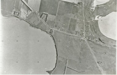
Black and white photograph, Aerial View of Lake Bolac, 1947
Aerial view of Lake Bolac (Boloke) taken in 1947. Fresh water lake at bottom left, salt lakes at top right, village at crossroads of north-south Glenelg highway and Ararat-Mortlake road.lake bolac, 1947, glenelg highway -
 Lake Bolac & District Historical Society
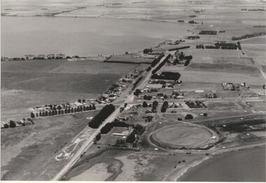
Black and white photograph, Aerial view of Lake Bolac township, circa 1970
Lake Bolac township, 1970. This picture shows the 2nd football oval, tennis courts, golf course and racecourse (front-right) above the salt lake and the Lake Bolac Common (front-left). The Primary School is still on its original site between the oval and the Ararat road. The High School is beside the fresh-water lake (centre back) and to its left are the early caravan park and bowling club. The Aquatic Club shed can just be seen behind the lake bank. Photograph taken by Lewis Wills.lake bolac, football oval, tennis courts, race track, golf course, bowling club, caravan park, aquatic club shed, primary school, high school -
 Lake Bolac & District Historical Society
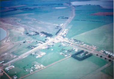
Colour photograph
Aerial view of Lake Bolac township, looking towards the north-east, taken circa 1968. The freshwater lake is top-right, the salt-lake is centre-left. The Presbyterian church, bottom right, is surrounded by Cyprus trees on the Woorndoo/Mortlake road. The hotel and general store are opposite each other on the crossroads of the Mortlake/Ararat and Ballarat/Hamilton roads and the sporting complex is behind the store next to the salt lake. The Primary School, No 854, is between the footy oval and the Ararat Road, centre left.lake bolac, freshwater lake, salt lake, presbyterian church, hotel, general store, sporting complex, primary school, no 854. -
 Robin Boyd Foundation
Document - Manuscript, Robin Boyd, Melbourne: 2001 AD, 1969
Searing critique on the public apathy of the environment in which we live, as well as the dichotomy of the professional view of the city and suburbs. Boyd imagines what Melbourne might be like in year 2001.Original manuscript of an article published as 'Melbourne 2001 AD' in "The Australian", 05.03.1969. This is the second of a series of three articles about Melbourne published on consecutive days (see D022 and D024).Typewritten (c copy), quarto, 7 pagesmelbourne, trams, flies, road congestion, robin boyd, manuscript -
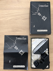 Robin Boyd Foundation
Functional object - Camera lens
Penleigh Boyd, Robin and Patricia Boyd's son, recalls that "Robin experimented with stereoscopic photography which, when viewed through either polaroid or red/green glasses, produced a three dimensional effect. A special double lens attachment with image splitting mirror was added in front of the normal camera lens to produce a double image similar to the image seen by each left and right eye". Robin experimented with stereoscopic photography when they lived in the 158 Riversdale Road Camberwell.Stereoscopic camera lens in a box with instructions in Japanese and Englishwalsh st miscellaneous, robin boyd -
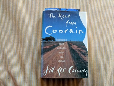 Robin Boyd Foundation
Book, Jill Ker Conway, The Road from Coorain: Recollections of a harsh and beautiful journey into adulthood, 1989
Hardcover w/Dust JacketBlue ballpoint handwritten inscription, first page: 'Patricia and John, / To keep home in your minds - / Much love, / Mary / September 1989' Printed cardboard flyer c. DL size with full colour print on one side and black and white printed text on the back. Flyer for Sotheby's 'Fine Australian Paintings' viewing held in Melbourne 26th November 1990. Printed adhesive mailing label affixed addressed to 'Mr John Davies / 290 Walsh Street / SOUTH YARRA / VIC / 3141'. Full colour image of painting on front: William Blamire Young, "The Prima Donna Awaits Her Cue", 81.5 x 41cm, Estimate $36,000|40,000australian biography, australian women, jill conway, smith college, australian history, walsh st library -
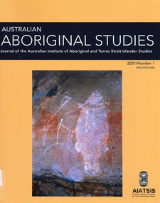 Victorian Aboriginal Corporation for Languages
Periodical, Australian Institute of Aboriginal and Torres Strait Islander Studies, Australian Aboriginal studies : journal of the Australian Institute of Aboriginal and Torres Strait Islander Studies, 2007
... hand. I aim to define a middle road between those views... hand. I aim to define a middle road between those views ...1. The moral lexicon of the Warlpiri people of central Australia LR Hiatt This paper discusses words that match ?Good? and ?Bad?; examples of ?Good? and ?Bad? behaviour; morality and law; and egalitarianism and dominance. It also presents a comparison with Gidjingarli (Burarra). 2. Mobs and bosses: Structures of Aboriginal sociality Patrick Mullins (Mount Druitt, NSW) A commonality of Aboriginal social organisation exists across the continent in communities as different as those from the Western Desert across to Cape York, from the towns of New South Wales and Western Australia to cities like Adelaide. This is found in the colloquial expressions ?mob? and ?boss?, which are used in widely differing contexts. Mobbing is the activity where relatedness, in the sense of social alliances, is established and affirmed by virtue of a common affiliation with place, common experience and common descent, as well as by the exchange of cash and commodities. Bossing is the activity of commanding respect by virtue of one?s capacity to bestow items of value such as ritual knowledge, nurturance, care, cash and commodities. Mobbing and bossing are best understood as structures in Giddens? sense of sets of rules and resources involved in the production of social systems, in this case social alliances. Mobbing and bossing imply a concept of a person as a being in a relationship. Attention needs to be given to the way these structures interact with institutions in the wider Australian society. 3. Recognising victims without blaming them: A moral contest? About Peter Sutton?s ?The Politics of Suffering: Indigenous Policy in Australia since the 1970s? and Gillian Cowlishaw?s replies Ma�a Ponsonnet (Universit� Paris- 8-Saint-Denis) Peter Sutton?s texts on Aboriginal violence, health and their politicisation are replied to using his methodology, and acknowledging his convincing points. Sutton rightly denounces a lack of lucidity and scientific objectivity in anthropological debates. These inadequacies impede identification of what Aboriginal groups can do to improve their situations for fear that this identification would lead to blame the victims. At the other end of the ethical spectrum, those who advocate a broader use of what I will call a ?resistance interpretation? of violence fail to recognise victims as such, on the implicit grounds that seeing victims as victims would deprive them of any agency, on the one hand, and entail blame, on the other hand. I aim to define a middle road between those views: the idea that victims should be acknowledged as such without being denied their agency and without being blamed for their own condition. This middle road allows identification of the colonisers? responsibilities in the contemporary situation of Indigenous communities in Australia, and to determine who can do what. Secondly, I show that Sutton?s texts convey, through subtle but recurrent remarks, an ideology of blame rather than a mere will to identify practical solutions. As a consequence, some of his proposals do not stand on a solid and objective causal analysis. 4. 'You would have loved her for her lore?: The letters of Daisy Bates Bob Reece (Murdoch University) Daisy Bates was once an iconic figure in Australia but her popular and academic reputation became tarnished by her retrograde views. Her credibility was also put in doubt through the exposure of her fictionalised Irish background. In more recent times, however, her ethnographic data on the Aborigines of Western Australia has been an invaluable source for Native Title claims, while her views on Aboriginal extinction, cannibalism and ?castes? are being seen as typical of her time. This article briefly reviews what has been the orthodox academic opinion of her scientific achievement before summarising what is reliably known of her early history and indicating what kind of person is revealed in the 3000 or more letters that she left behind. 5. What potential might Narrative Therapy have to assist Indigenous Australians reduce substance misuse? Violet Bacon (Curtin University of Technology) Substance misuse is associated with adverse consequences for many Australians including Aboriginal and Torres Strait Islander peoples. Extensive research has been conducted into various intervention, treatment and prevention programs to ascertain their potential in reducing substance misuse within Aboriginal and non-Aboriginal communities. I explore the potential of Narrative Therapy as a counselling intervention for assisting Indigenous Australians reduce the harm associated with substance misuse. 6. Bone points from the Adelaide River, Northern Territory Sally Brockwell (University of Canberra) and Kim Akerman (Moonah) Large earth mounds located next to the vast floodplains of the lower Adelaide River, one of the major tropical rivers draining the flat coastal plains of northern Australia, contain cultural material, including bone points. The floodplains of the north underwent dynamic environmental change from extensive mangrove swamps in the mid-Holocene, through a transition phase of variable estuarine and freshwater mosaic environments, to the freshwater environment that exists today. This geomorphological framework provides a background for the interpretation of the archaeology, which spans some 4000 years. 7. A different look: Comparative rock-art recording from the Torres Strait using computer enhancement techniques Liam M Brady (Monash University) In 1888 and 1898, Cambridge University?s Alfred C Haddon made the first recording of rock-art from the Torres Strait islands using photography and sketches. Systematic recording of these same paintings and sites was carried out from 2000 to 2004 by archaeologists and Indigenous Torres Strait Islander and Aboriginal communities as part of community-based rock-art recording projects. Computer enhancement techniques were used to identify differences between both sets of recordings, to reveal design elements that Haddon missed in his recordings, and to recover images recorded by Haddon that are today no longer visible to the naked eye. Using this data, preliminary observations into the antiquity of Torres Strait rock-art are noted along with recommendations for future Torres Strait region rock-art research and baseline monitoring projects. 8. Sources of bias in the Murray Black Collection: Implications for palaeopathological analysis Sarah Robertson (National Museum of Australia) The Murray Black collection of Aboriginal skeletal remains has been a mainstay of bio-anthropological research in Australia, but relatively little thought has been given to how and why this collection may differ from archaeologically obtained collections. The context in which remains were located and recovered has created bias within the sample, which was further skewed within the component of the collection sent to the Australian Institute of Anatomy, resulting in limitations for the research potential of the collection. This does not render all research on the collection unviable, but it demonstrates the importance of understanding the context of a skeletal collection when assessing its suitability for addressing specific research questions.maps, b&w photographs, colour photographs, illustrations, graphs, chartswarlpiri, sociology, daisy bates, substance abuse, narrative therapy, rock art, technology and art, murray black collection, pleistocene sites, watarrka plateau -
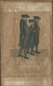 Uniting Church Archives - Synod of Victoria
Printed etching, Undated c.1790
James Hamilton (1740-1827) joined the fledgling Methodist society and became a local preacher. He helped John Wesley to organise Methodism in Scotland. He became an influential member at Wesley's Chapel in City Road London. John Wesley 1703-1791 was the founder of Methodism.Printed etching mounted on timber. Depicts 3 men in profile view as they walk down the street.1. James Hamilton M.D. 2. Revd. John Wesley M.A. 3. Revd. Joseph Cole Drawn as they were seen walking in the Streetjames hamilton, rev john wesley, rev joseph cole, methodist -
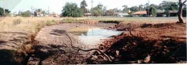 Hume City Civic Collection
Photograph
The old Calder Highway before the construction of the duplication of the Calder Highway between the Railway crossing and Plumpton Road.A coloured panoramic view of the old Caler Highway at Diggers Rest. It is unmounted.old calder highway, diggers rest, plumpton road, railways, george evans collection -
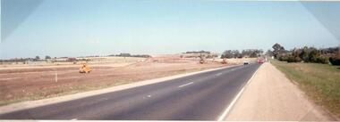 Hume City Civic Collection
Photograph
This photograph is of the duplication of the Calder Highway at Diggers Rest in the vicinity of Plumpton Road.A coloured panoramic view of the construction of the duplication of the Calder Highway in the vicinity of Plumpton Road. It is unmounted.calder highway, diggers rest, highway duplication, road construction and maintenance, plumpton road, george evans collection -
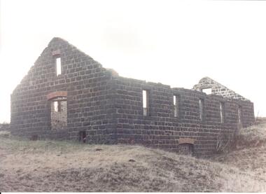 Hume City Civic Collection
Photograph
Rosenthal Winery in Vineyard Road, Sunbury was one of the first wineries established in the area. It was owned by R. F. Kurrle. The roofless building still stands on the property which was part of the dairy farm owned by Tom and Angela Millett. The last vintage from the property was crushed in 1910.A view of the exterior of the ruins of Rosenthal Winery showing 2 sides. It is a bluestone building with a red brick arched doorway at the front and a small narrow arched window above the doorway. Along the side there is another arched doorway at the lower level and 5 paneless windows along the upper level. The pitched gable ends are still standing but the building is roofless.rosenthal winery, wineries, vineyards, vineyard road, sunbury wineries, kurrle, r. f., millett, tom, angela, sunbury, george evans collection -
 Hume City Civic Collection
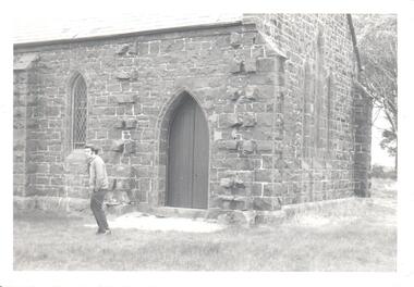
Photograph, pre 1970
The photograph of St Mary's Anglican Church at Bulla was taken before the completion of the airport at Tullamarine. Originally the church occupied a site on Oaklands Road near the Old Bulla Road. It was shifted to its present site in Bulla next to the old council chambers when the airport was built because the old site was near an important runway.A black and white photograph of a partial view of a bluestone church showing a rear and side view. There are three simple pointed arch windows across the restry and one on the side wall and a wooden door leading into the vestry.st mary's anglican church, bluestone buildings, george evans collection -
 Hume City Civic Collection
Photograph, c late 1980s
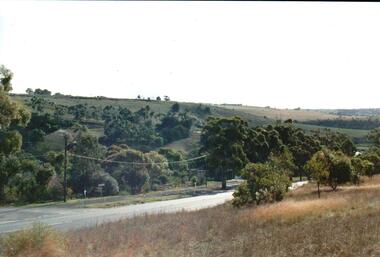
... A coloured photograph of the Bulla Hill along Sunbury Road... Sunbury Road with a view of the cutting on the distant hillside ...The photograph shows a section of the original settlement of the Bulla township. The cutting on the hillside is significant as it is the remains of one of the original stream crossings in Victoria.A coloured photograph of the Bulla Hill along Sunbury Road with a view of the cutting on the distant hillside. The photograph is a view of the old Bulla township looking to the NW. There is a wide grassy verge in the foreground.bulla township, deep creek, wright, william 'tulip', sunbury road, george evans collection -
 Hume City Civic Collection
Photograph, c late 1990s
The series of 9 photographs were taken to be included in a study of archaeological sites and Aboriginal rings in the Sunbury area. Five earth rings which are thought to be associated with male initiation ceremonies have been identified in Sunbury. Only 3 others have been found in the rest of Victoria. Despite rapid development in the area, those sites are protected heritage sites.A view of the Aboriginal ring and sacred site and its close proximity to a proposed housing estate at Sherwood near Racecourse Road.aboriginal culture, aboriginal rings, sacred sites, george evans collection -
 Hume City Civic Collection
Photograph, late 1980s
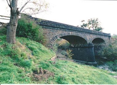
The road bridge over Jackson's Creek in Sunbury was built in 1870 and was in use until a wider bridge was built when Sunbury Road was rebuilt in the early 1970s.A coloured photograph taken from the NE side of the river bank of a complete view of the bluestone bridge at Macedon Street. The two eliptical arches and the protruding pylon as well as the underside of the bluestone span are clearly visible.transport, roads and bridges, jacksons creek, harris, thomas lascelles, george evans collection -
 Hume City Civic Collection
Photograph, late 1990s
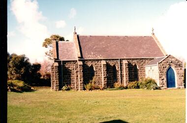
St. Mary's Anglican Church at Bulla was originally built on the outskirts of Bulla township in 1858. In the early 1970s it was moved to its present site to make way for the flight path at the newly constructed Tullamarine Airport. The former site was on the corner of Oaklands and Sunbury Roads and is covered with vegetation. The church was designed by Thomas Taylor.A profile view of the west side of St. Mary's Anglican Church at Bulla and the garden area around the church. A slate covered gable roof has been constructed over the porch nave and chancery with a cross at each end of the roof over the nave. 6 bluestone buttresses and 3 lance windows are along the side with 3 small lancet windows and a blue painted wooden lancet door on the porch.churches, religion, taylor, thomas, st. mary's anglican church, george evans collection -
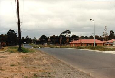 Hume City Civic Collection
Photograph, early 1990s
The series of 5 photographs feature different views of the Woodlands Housing Development which opened up land bounded by Gap and Anderson Roads, Cornish Street and Elizabeth Drive in the early 1990s. It was a large housing development built close to Sunbury township.A coloured photograph of one of the last housing developments which took place in the old township area. It is a photograph taken at the north end of Anderson Road looking towards Gap Road. One house has been built and there are a number of 'For Sale' signs of blocks fronting Anderson Road. Guttering and driveways have been formed on one side of the road.housing developments, anderson road, george evans collection -
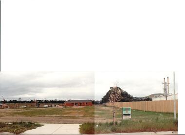
 Hume City Civic Collection
Photograph, early 1990s
The series of 5 photographs feature different views of the Woodlands housing development which opened up land bounded by Gap and Anderson Roads, Cornish Street and Elizabeth Drive in the early 1990s. It was a large housing development built close to Sunbury township.A view of the northern boundary of the Woodlands housing development in Anderson Road. A paling fence divides the estate from the 'Malley' factory, now 'Storage King' which is on the corner of Cornish Street and Anderson Road. A 'For Sale' sign is in the foreground and a partly built house is in the middle distance.housing developments, anderson road, george evans collection -
 Hume City Civic Collection
Photograph, early 1990s
The series of 5 photographs feature different views of the Woodlands housing development which opened up land bounded by Gap and Anderson Roads, Cornish Street and Elizabeth Drive in the early 1990s. It was a large housing development built close to Sunbury township.A coloured photograph of a new housing development taken in Anderson Road looking west towards Elizabeth Drive and the leisure centre. Some housing construction is in the middle distance.housing developments, anderson road, george evans collection -
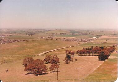 Hume City Civic Collection
Photograph, 1980s
The photograph was taken above Reservoir Road on the lower slopes of Mt. Holden. It is looking south down Wilson's Lane towards some of the early Sunbury developments which grew around the Gap Road area in the early 1980s.A landscape coloured photograph with rounded corners. It is a panoramic view of Sunbury taken from the southern slopes of Mt. Holden. In the foreground there is a small cluster of trees and in the middle distance there is some evidence of housing development. Bald Hill can be seen on the skyline.wilson's lane, mt. holden, bald hill, sunbury, george evans collection -
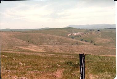 Hume City Civic Collection
Photograph, early 1980s
The Sunbury Tip was transferred from the end of Reservoir Road as housing development spread in that area to a site on the NW side of Mt. Holden near Riddell Road in the early 1980s.A landscape coloured photograph with rounded corners. It is a panoramic view of open country NW of Sunbury near Riddell Road. There is a fence post with barbed wire hanging from it in the immediate foreground and Macedon Ranges and part of the Western Highlands can be seen across the skyline.macedon ranges, mt. macedon, camel's hump, sunbury municipal tip, george evans collection -
 Hume City Civic Collection
Photograph, early 1980s
The Headland Estate housing development began in the early 1980s. It was situated west of Sunbury and was bounded by Elizabeth Drive, Reservoir Road, Phillip Drive and Stewart's Lane.A coloured landscape photograph with rounded corners of a view of Sunbury overlooking the Headland Estate before its development. There is a rocky outcrop on the LHS of the photograph and a lightly timbered area in the middle distance. Sunbury can be seen in the distance.headland estate, mt. holden, sunbury township, george evans collection -
 Hume City Civic Collection
Photograph, Early 1970s
In the early 1970s the eastern approach to Sunbury was changed. The stone bridge spanning the Jacksons Creek was replaced by a wider concrete structure and dangerous curves were taken out of the road. The area on the LHS of the photograph including the two arched stone bridge has been incorporated into a public picnic area.A black and white panoramic view of the eastern approach to Sunbury and the Sunbury township before the road was widened and straightened and the new bridge was built. There are two cars in the foreground. One is approaching the bridge and the other is leaving Sunbury.macedon street, macedon street road bridge, jacksons creek, sunbury township, george evans collection -
 Hume City Civic Collection
Photograph, 1980s
This photograph was taken from the intersection of Loemans and Sunbury Roads. It overlooks the site of the former Bula Primary School and the hillside where stones were laid and painted to form the words "Bulla". The lettering was possible a project carried out by the pupils at the school.A black and white photograph of a panoramic view overlooking the former Bulla Primary School. The photograph has been taken from the intersection of Loemans and Sunbury Roads.bulla primary school, bulla township, george evans collection -
 Hume City Civic Collection
Photograph, Early 1970s
The photograph was taken when Sunbury township did not extend far beyond Anderson Road to the west and Powlett Street to the east. The Paynes housing development can be seen scattered across the hillside between Gap Road and Mitchells Lane.A black and white photograph of a panoramic view of Sunbury township looking west and taken from above the Goonawarra Winery. Sheep are grazing on the hilside in the foreground.sunbury township, goonawarra winery, george evans collection -
 Hume City Civic Collection
Photograph
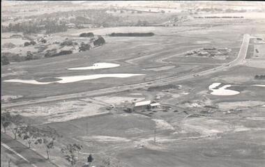
A black and white aerial photograph of an aerial view of the newly established Goonawarra Golf Club. Sunbury Road is visible in the bottom LH corner and Francis Avenue crosses the photograph. The clubhouse is in the centre of the photograph and some early housing development is in the distance.goonawarra gold club, housing developments, regional newspaper, george evans collection -
 Forests Commission Retired Personnel Association (FCRPA)
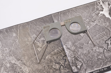
Pocket Stereoscope
This pocket stereoscope was used to view a pair of separate and overlapping aerial photos as a single three-dimensional image. It was small and could be easily used in the field. Larger, mirror stereoscope were also available in some offices. The aerial images were used to map forest types, timber stands, new roads and tracks, firebreaks, boundaries of timber harvesting, plantations, bushfires, insect and disease attack and so on In 1928, the Forests Commission undertook its first major aerial photography project over 15,000 acres of forest which is said to be the first of its kind in Australia. During the Second World War, large areas of Victoria were photographed by RAAF and used to produce orthophoto maps. By 1945 aerial photography of 13,000 square miles (3.4 M ha) was completed, including much of the inaccessible eastern forests. The Forests Commission started developing its own small format photography in the early 1970s. Simple, cheap and rapid methods of obtaining photographs using 70mm and 35mm cameras were developed Small pocket stereoscope to interprete aerial photographs in the field Adjustable lenses on foldaway wire legsSokkisha Tokyoforest measurement -
Lakes Entrance Regional Historical Society (operating as Lakes Entrance History Centre & Museum)
Photograph, 1/09/1933 12:00:00 AM
Also three other similar photographs taken at same time 05197.1 showing cave house in distance. and 05197.2 and .3Black and white photograph showing view of Buchan flats from Gelantipy Road with children June and Rex Fish standing by fence Buchan Victoriabridges, township, waterways