Showing 13180 items matching "government-act"
-
 Federation University Historical Collection
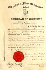
Certificate, Ballarat School of Mines Competency as a Geologist Certificate, o1/06/1911
William Baragwanath became Victorian Government Geologist. Cream coloured vellum certificate with blues Ballarat School of Mines Crest and red seal. It is a Ballarat School of Mines Certificate of Competency as a Geologist made out to William Baragwanath in 1911. The Certificate of Competency included passing examinations in Geology, Mining geology, Mineralogy, Petrology, Mine Surveying and Chemistry.Signed on left 'W. Baragwanath'ballarat school of mines, geology, petrology, mineralogy, surveying, chemistry, baragwanath, martell, frederick martell, maddern, geology alumni, william baragwanath -
 Unions Ballarat
American government and politics, Potter, Allen M, 1978
US politics and government. Written for a British audience.Politics and government - USA. (Published in 1955.)Paper; book. Cover: author's name and title.btlc, ballarat trades hall, ballarat trades and labour council;, politics - united states of america, government - united states of america, constitution - united states of america, federalism -
 Parks Victoria - Gabo Island Lightstation
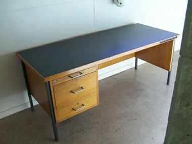
Desk
Government issue desk. Manufactured (perhaps 1970s)It has second level contributory significance as a furnishing that has remained at the lightstation to demonstrate its more recent working operations.Wooden desk with metal frame. Dark grey vinyl top, three drawers on left-hand sde with metal handles. Second drawer has filing inserts.Right-hand front leg on black sticker. "C. of A. / D.O.T. 147110" -
 Melbourne Tram Museum
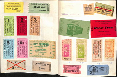
Ephemera - Exercise Book, Keith Stodden, "Tickets 2", 1950's to 1980's
Exercise or Mapping book - Australian Mapping book, decorative cover with mathematical tables on the rear, plain paper, 48 pages holding tickets collected by Keith Stodden. Titled "Tickets 2". Tickets have been positioned using stamp hinges. Pages 1 - Sydney 2 - 5 - mixed VR Bus, MMTB, railway tours, National Trust, and other admission tickets 6 - 8 - Brisbane 9 - BTMS, TAA 10 - TMSV, Sydney 11 - MMTB 12 - Sandhurst Town, National Trust, mixed admission 13 - Sydney 14 - MMTB Bus 15 - Adelaide 16 - 19 - Brisbane 20 - 21- Melbourne Rail, 22 - Melbourne Pageant 23 - 24 - Melbourne Rail and Tram - Travel cards 25 - 26 - Auckland, MOTAT 27 - 28 - Travelcards, Ballarat, Bendigo, Perth, MMTB Swimming ticket 29 - Melbourne rail 30 - Ansett bus, rail and MTT Perth 31 - 32 - Rail travel cards 33 - CRB Westgate bridge toll, Neighbourhood tickets 34 - ARHS ACT, Westgate bridge toll vouchers, 35 - 37 - MMTB, Rail travel cards, ACT bus 38 - Muni, and Travelcard 39 - 40 - Rail, 41 - 42 - travel cards, ARHS ACT 43 - 44 - Travelcards, Santa tram Bendigo 45 - blank 46 - VicRail country ticket, Ansett boarding pass 47 - Levers coachlines.trams, tramways, tickets, the met, mmtb, adelaide, sec, tmsv, sydney, buses -
 Kew Historical Society Inc
Map, MMBW, MMBW Town of Kew, 1910-21
The Melbourne and Metropolitan Board of Works (MMBW) was established by an act of the Victorian Parliament in 1890 to prepare for and to implement a sewerage and water reticulation system across what was then inner Melbourne, its surrounding and middle distance suburbs, including Kew. The MMBW was disbanded in 1991.The map collection of the Kew Historical Society has at its core the historic maps assembled and originally stored in the City Engineer's Department of the City of Kew. These include maps in a number of scales. The vast majority of maps were produced by the MMBW in the first two decades of the twentieth century, and are solid working maps, backed by linen for durability. These maps are historically significant to Kew, the City of Boroondara and to the history of the development of state utilities in Victoria. A number of the Kew maps have additional details added by former municipal officers, including the levels reached by various floods. As these were working documents, information was added to them long after the period of their initial production and distribution.Early map of the Town of Kew, created after 1910, at a scale 440 ft to 1 inch. The 'assembled' map by the City of Kew Engineer's Department includes scaled down copies of The Melbourne and Metropolitan Board of Works maps, Nos. 39, 40, 64, 65, 66, 67, 68, and 117. The map covers the entirety of the Town of Kew, bordered on its north and west by the River Yarra, by Burke Road in the East and Barkers Road in the south. The map shows the extent of urban development by that time, prominent institutions and the outlines of built structures in the municipality. TOWN OF KEW / SCALE 400 FEET TO 1 INCHmelbourne & metropolitan board of works, mmbw maps, mmbw plans, town of kew, cartography -
 Kew Historical Society Inc
Map, MMBW, MMBW Plan No.39 Kew & Heidelberg, 1900-1910
The Melbourne and Metropolitan Board of Works (MMBW) was established by an act of the Victorian Parliament in 1890 to prepare for and to implement a sewerage and water reticulation system across what was then inner Melbourne, its surrounding and middle distance suburbs, including Kew. The MMBW was disbanded in 1991.The map collection of the Kew Historical Society has at its core the historic maps assembled and originally stored in the City Engineer's Department of the City of Kew. These include maps in a number of scales. The vast majority of maps were produced by the MMBW in the first two decades of the twentieth century, and are solid working maps, backed by linen for durability. These maps are historically significant to Kew, the City of Boroondara and to the history of the development of state utilities in Victoria. A number of the Kew maps have additional details added by former municipal officers, including the levels reached by various floods. As these were working documents, information was added to them long after the period of their initial production and distribution.Early map of part of the Borough of Kew, created in the first decade of the twentieth century, at a scale 160 ft to 1 inch. The map covers what was then the north western section of Kew, bordered on its north by Wills Street and the Kew Lunatic Asylum, in the west by the River Yarra [and the later added Yarra Boulevard] , by Princess Street in the East and Holroyd Street in the south. The map shows the extent of urban development by that time, prominent institutions and the outlines of built structures in the municipality. Contour lines were added in ink to the map at a later stage.MELBOURNE AND METROPOLITAN BOARD OF WORKS / PLAN NO. 39 / KEW & HEIDELBERGmelbourne & metropolitan board of works, mmbw maps, mmbw plans, borough of kew, cartography -
 Kew Historical Society Inc
Map, MMBW, MMBW Plan No.40 Collingwood & Kew, 1900-1910
The Melbourne and Metropolitan Board of Works (MMBW) was established by an act of the Victorian Parliament in 1890 to prepare for and to implement a sewerage and water reticulation system across what was then inner Melbourne, its surrounding and middle distance suburbs, including Kew. The MMBW was disbanded in 1991.The map collection of the Kew Historical Society has at its core the historic maps assembled and originally stored in the City Engineer's Department of the City of Kew. These include maps in a number of scales. The vast majority of maps were produced by the MMBW in the first two decades of the twentieth century, and are solid working maps, backed by linen for durability. These maps are historically significant to Kew, the City of Boroondara and to the history of the development of state utilities in Victoria. A number of the Kew maps have additional details added by former municipal officers, including the levels reached by various floods. As these were working documents, information was added to them long after the period of their initial production and distribution.Early map of part of the Borough of Kew, created in the first decade of the twentieth century, at a scale 160 ft to 1 inch. The map covers what was then the south western section of Kew, bordered on its north by Studley Park Road, in the west by Walmer Street and the River Yarra, by High Street South and Princess Street in the East and Barkers Road in the south. The map shows the extent of urban development by that time, prominent institutions and the outlines of built structures in the municipality. Contour lines and historic flood levels were added in ink to the map at a later stage.MELBOURNE AND METROPOLITAN BOARD OF WORKS / PLAN NO. 40 / COLLINGWOOD & KEWmelbourne & metropolitan board of works, mmbw maps, mmbw plans, borough of kew, cartography -
 Kew Historical Society Inc
Map, MMBW, MMBW Plan No.64 Kew & Heidelberg, 1900-1910
The Melbourne and Metropolitan Board of Works (MMBW) was established by an act of the Victorian Parliament in 1890 to prepare for and to implement a sewerage and water reticulation system across what was then inner Melbourne, its surrounding and middle distance suburbs, including Kew. The MMBW was disbanded in 1991.The map collection of the Kew Historical Society has at its core the historic maps assembled and originally stored in the City Engineer's Department of the City of Kew. These include maps in a number of scales. The vast majority of maps were produced by the MMBW in the first two decades of the twentieth century, and are solid working maps, backed by linen for durability. These maps are historically significant to Kew, the City of Boroondara and to the history of the development of state utilities in Victoria. A number of the Kew maps have additional details added by former municipal officers, including the levels reached by various floods. As these were working documents, information was added to them long after the period of their initial production and distribution.Early map of part of the Borough of Kew, created in the first decade of the twentieth century, at a scale 160 ft to 1 inch. The map covers what was then the northern most part of Kew, bordered on its north and west by the Yarra River, in the East by Connor's Creek and by the Asylum in the south. The map shows the extent of urban development by that time, prominent institutions and the outlines of built structures in the municipality. Contour lines and historic flood levels were added in ink to the map at a later stage.MELBOURNE AND METROPOLITAN BOARD OF WORKS / PLAN NO. 64 / KEW & HEIDELBERGmelbourne & metropolitan board of works, mmbw maps, mmbw plans, borough of kew, cartography -
 Kew Historical Society Inc
Map, MMBW, MMBW Plan No.65 Kew & Heidelberg, 1900-1910
The Melbourne and Metropolitan Board of Works (MMBW) was established by an act of the Victorian Parliament in 1890 to prepare for and to implement a sewerage and water reticulation system across what was then inner Melbourne, its surrounding and middle distance suburbs, including Kew. The MMBW was disbanded in 1991.The map collection of the Kew Historical Society has at its core the historic maps assembled and originally stored in the City Engineer's Department of the City of Kew. These include maps in a number of scales. The vast majority of maps were produced by the MMBW in the first two decades of the twentieth century, and are solid working maps, backed by linen for durability. These maps are historically significant to Kew, the City of Boroondara and to the history of the development of state utilities in Victoria. A number of the Kew maps have additional details added by former municipal officers, including the levels reached by various floods. As these were working documents, information was added to them long after the period of their initial production and distribution.Early map of part of the Borough of Kew, created in the first decade of the twentieth century, at a scale 160 ft to 1 inch. The map covers what was then the south central part of Kew, bordered on its north by Malmsbury Street, in the west by Florence Avenue, in the south by Barkers Road, and in the east by Princess Street. The map shows the extent of urban development by that time, prominent institutions and the outlines of built structures in the municipality. Contour lines were added in ink to the map at a later stage.MELBOURNE AND METROPOLITAN BOARD OF WORKS / PLAN NO. 65 / KEW & HEIDELBERGmelbourne & metropolitan board of works, mmbw maps, mmbw plans, borough of kew, cartography -
 Kew Historical Society Inc
Map, MMBW, MMBW Plan No.66 Kew, 1900-1910
The Melbourne and Metropolitan Board of Works (MMBW) was established by an act of the Victorian Parliament in 1890 to prepare for and to implement a sewerage and water reticulation system across what was then inner Melbourne, its surrounding and middle distance suburbs, including Kew. The MMBW was disbanded in 1991.The map collection of the Kew Historical Society has at its core the historic maps assembled and originally stored in the City Engineer's Department of the City of Kew. These include maps in a number of scales. The vast majority of maps were produced by the MMBW in the first two decades of the twentieth century, and are solid working maps, backed by linen for durability. These maps are historically significant to Kew, the City of Boroondara and to the history of the development of state utilities in Victoria. A number of the Kew maps have additional details added by former municipal officers, including the levels reached by various floods. As these were working documents, information was added to them long after the period of their initial production and distribution.Early map of part of the Borough of Kew, created in the first decade of the twentieth century, at a scale 160 ft to 1 inch. The map covers what was then the south eastern part of Kew, bordered on its north by Adeney Avenue, in the west by Sackville Street, in the south by Barkers Road, and in the east by Burke Road. The map shows the extent of urban development by that time, prominent institutions and the outlines of built structures in the municipality. Contour lines were added in ink to the map at a later stage.MELBOURNE AND METROPOLITAN BOARD OF WORKS / PLAN NO. 66 / KEW melbourne & metropolitan board of works, mmbw maps, mmbw plans, borough of kew, cartography -
 Kew Historical Society Inc
Map, MMBW, MMBW Plan No.67 Kew, 1900-1910
The Melbourne and Metropolitan Board of Works (MMBW) was established by an act of the Victorian Parliament in 1890 to prepare for and to implement a sewerage and water reticulation system across what was then inner Melbourne, its surrounding and middle distance suburbs, including Kew. The MMBW was disbanded in 1991.The map collection of the Kew Historical Society has at its core the historic maps assembled and originally stored in the City Engineer's Department of the City of Kew. These include maps in a number of scales. The vast majority of maps were produced by the MMBW in the first two decades of the twentieth century, and are solid working maps, backed by linen for durability. These maps are historically significant to Kew, the City of Boroondara and to the history of the development of state utilities in Victoria. A number of the Kew maps have additional details added by former municipal officers, including the levels reached by various floods. As these were working documents, information was added to them long after the period of their initial production and distribution.Early map of part of the Borough of Kew, created in the first decade of the twentieth century, at a scale 160 ft to 1 inch. The map covers what was then the north central part of Kew, bordered on its north by the Outer Circle Railway Spruzen and Beresford Avenues, in the west by Princess Street, in the south by High Street, and in the east by (about) Belford Road. The map shows the extent of urban development by that time, prominent institutions and the outlines of built structures in the municipality. Contour lines were added in ink to the map at a later stage.MELBOURNE AND METROPOLITAN BOARD OF WORKS / PLAN NO. 67 / KEW melbourne & metropolitan board of works, mmbw maps, mmbw plans, borough of kew, cartography -
 Kew Historical Society Inc
Map, MMBW, MMBW Plan No.68 Kew, 1900-1910
The Melbourne and Metropolitan Board of Works (MMBW) was established by an act of the Victorian Parliament in 1890 to prepare for and to implement a sewerage and water reticulation system across what was then inner Melbourne, its surrounding and middle distance suburbs, including Kew. The MMBW was disbanded in 1991.The map collection of the Kew Historical Society has at its core the historic maps assembled and originally stored in the City Engineer's Department of the City of Kew. These include maps in a number of scales. The vast majority of maps were produced by the MMBW in the first two decades of the twentieth century, and are solid working maps, backed by linen for durability. These maps are historically significant to Kew, the City of Boroondara and to the history of the development of state utilities in Victoria. A number of the Kew maps have additional details added by former municipal officers, including the levels reached by various floods. As these were working documents, information was added to them long after the period of their initial production and distribution.Early map of part of the Borough of Kew, created in the first decade of the twentieth century, at a scale 160 ft to 1 inch. The map covers what was then the north central part of Kew, bordered in the north by Oak Avenue, in the west by the Yarra River and Connor's Creek, in the south by Beresford and Carnegie Avenues, and in the east by Glass's Creek and Burke Road. The map shows the extent of urban development by that time, prominent institutions and the outlines of built structures in the municipality. Contour lines and the levels of historic floods were added in ink to the map at a later stage.MELBOURNE AND METROPOLITAN BOARD OF WORKS / PLAN NO. 68 / KEW melbourne & metropolitan board of works, mmbw maps, mmbw plans, borough of kew, cartography -
 Kew Historical Society Inc
Map, MMBW, MMBW Plan No.117 Heidelberg & Kew, 1900-1910
The Melbourne and Metropolitan Board of Works (MMBW) was established by an act of the Victorian Parliament in 1890 to prepare for and to implement a sewerage and water reticulation system across what was then inner Melbourne, its surrounding and middle distance suburbs, including Kew. The MMBW was disbanded in 1991.The map collection of the Kew Historical Society has at its core the historic maps assembled and originally stored in the City Engineer's Department of the City of Kew. These include maps in a number of scales. The vast majority of maps were produced by the MMBW in the first two decades of the twentieth century, and are solid working maps, backed by linen for durability. These maps are historically significant to Kew, the City of Boroondara and to the history of the development of state utilities in Victoria. A number of the Kew maps have additional details added by former municipal officers, including the levels reached by various floods. As these were working documents, information was added to them long after the period of their initial production and distribution.Early map of part of the Borough of Kew, created in the early twentieth century, at a scale 160 ft to 1 inch. The map covers what was then the north eastern part of Kew showing the natural landscape and limited development on the south side of the Yarra River. In the Kew section, south of the river, the land is occupied currently by the Greenacres and Kew Golf Clubs. The map shows the extent of urban development by that time and the outlines of the few built structures in the municipality. The height above sea level of all parts of the landscape are indicated numerically in feet. Contour lines and the levels of historic floods were added in ink to the map at a later stage. MELBOURNE AND METROPOLITAN BOARD OF WORKS / PLAN NO. 117 / HEIDELBERG & KEW melbourne & metropolitan board of works, mmbw maps, borough of kew, cartography, mmbw plan no. 117, kew (vic.) -- maps, heidelberg (vic.) -- maps -
 Kew Historical Society Inc
Map, MMBW, River Yarra Beautification Schemes, c.1913
The Melbourne and Metropolitan Board of Works (MMBW) was established by an act of the Victorian Parliament in 1890 to prepare for and to implement a sewerage and water reticulation system across what was then inner Melbourne, its surrounding and middle distance suburbs, including Kew. The MMBW was disbanded in 1991.The map collection of the Kew Historical Society has at its core the historic maps assembled and originally stored in the City Engineer's Department of the City of Kew. These include maps in a number of scales. The vast majority of maps were produced by the MMBW in the first two decades of the twentieth century, and are solid working maps, backed by linen for durability. These maps are historically significant to Kew, the City of Boroondara and to the history of the development of state utilities in Victoria. A number of the Kew maps have additional details added by former municipal officers, including the levels reached by various floods. As these were working documents, information was added to them long after the period of their initial production and distribution.Map of the City of Kew showing part of the River Yarra Beautification Schemes. The map shows development to date and the flood levels reached in 1923 and 1924. This map may have been adapted from an earlier map, as most development in central Kew and Studley Park had occurred by this date yet numerous streets are not represented. Public buildings and institutions are clearly represented and named on the map as are significant public transport infrastructure (eg the Outer Circle railway).MELBOURNE AND METROPOLITAN BOARD OF WORKS / RIVER YARRA BEAUTIFICATION SCHEMES / SCHEME / SCALE 10 CHAINS TO AN INCHmelbourne & metropolitan board of works, mmbw maps, mmbw plans, city of kew, flood levels -- kew (vic.), cartography -
 Melbourne Tram Museum
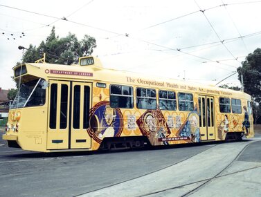
Photograph - Z1.39 at Preston Workshops, Michael McLeod, c. 1990
Photograph shows Z1 No. 39 (with "00" on the route number box) at Preston Workshops. The tram is in a livery advertising the Occupational Health and Safety Act in Melbourne, on behalf of the Department of Labour. The tram also had trolley poles installed. Photo by Michael McLeod.Shows a now-scrapped tram with obsolete equipment (i.e., trolley poles) and livery that advertised legislation.Colour Photograph - Z1.39 at Preston Workshopstrams, tramways, z1 class, public transport, tram 39, all over advertising -
 Ballarat Tramway Museum
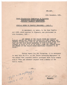
Document, State Electricity Commission of Victoria (SECV), "Special order to traffic personnel", 19/12/1961
Notice to traffic personnel dated 19/12/1961 that following an amendment to the Road Traffic Act 1958, that staff must advise with a "Name and Address" request from a member of the Police Force. This varied rule 15(c) of the Rules Governing Employees.Yields information about the giving name and address to police.Notice duplicated on quarto paper.In the bottom left hand corner has notes "1937 = 18 employees and 1962 = 17, 19 & 25"secv, trams, tramways, police, road rules -
 Bendigo Historical Society Inc.
Document - LYDIA CHANCELLOR COLLECTION; HIS ROYAL HIGHNESS THE PRINCE OF WALES VISIT TO MCG INVITATION
An invitation on damaged card with the words, ' In Honor and in the Presence of His Royal Highness The Prince of Wales, K.G., P.C., G.M.M.G., G.C.V.O., G.M.B.E., M.C. The Government of Victoria Requests the honor of the Company of The Worshipful the Mayor of Bendigo & Mrs. Curnow at the Melbourne Cricket Ground, Monday, 31st May, 1920 at a Demonstration of Physical Culture to be given by Children of the Metropolitan State Schools. Admit two only. Guests are requested to be in their places at 1.40 p.m. Please present this Card at the Members' Entrance. The Lower Tier of Seats in the Grey-Smith Stand, is on the West Side of the Members' Pavilion, is Reserved for Government Guests to the extent of its seating capacity. Entrance near the Bowling Green.'civic mementoes, royal souvenirs, invitation, lydia chancellor, royal family, melbourne cricket ground, m.c.g., official invitation, invitation, royal tour, the prince of wales -
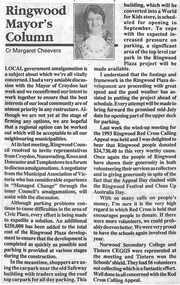 Ringwood and District Historical Society
Newspaper, Scrapbook Clipping, Library Collection, Ringwood, Victoria, `
``Newspaper clipping from "The Post" 15 -6- 94 P13 - Ringwood Mayor's Column. Cr. Margaret CheeversThe council was concerned about local government amalgamation.At its last meeting, Ringwood Council resolved to invite representatives from Croydon, Nunawading Knox, and Doncaster and Templestowe to a forum to discuss amalgamations.` -
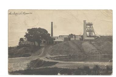 Buninyong & District Historical Society
Postcard - Original Photograph, New Imperial Mine, Hiscock's, Postcard, 1909
historic New Imperial Mine, Hiscock's, Postcardon reverse; 17/2/09 Dear Mr. Thomas Many thanks for the papers. Kind regards from all, your's sincerely R Kerr Mr. Thomas Government Battery Rutherglenmining, new imperial gold mine, hiscocks -
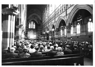 Melbourne Legacy
Photograph, Legacy 50th Anniversary, 1973
Four photos of the 50th Anniversary rededication service at St Pauls Cathedral in 1973. 00455.1 shows a group of men holding a Legacy torch near the altar and priests. Photos came from an envelope marked P1 Federal Conference 1973 / 50 Year anniversary / 1983 Morewell / 1973 Legacy March ANZAC Day, 50 yr celebration, inclusion in ANZAC Day March authority of RSL". See items 00452, 00453, 00454, 00391. A record of a church service marking the 50th anniversary of Legacy during the Golden Jubilee year 1973.Black and white photo x 4 of a church service for the 50th Anniversary.All stamped "This Photograph is the compliments of the Ministry of Tourism, Government of Victoria. Please acknowledge Michael Cheshire" in grey ink. 00455.1 Label on front says "Re-dedication service at St.Pauls Cathedral".golden jubilee, 50th anniversary, church service -
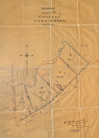 Ringwood and District Historical Society
Plan, Subdivision of Crown Lot 19, Ringwood, Victoria - circa 1915
Surveyor's map on wax paperSubdivision map includes Mullum Creek, Government Road to Anderson's Creek, later Warrandyte Road, Government Road to Lillydale, later Whitehorse Road, small creek bridge, later Sandy Creek at Ringwood Lake. Buildings marked include Roman Catholic Church, O.J. Pratt's House and Pratt's butcher shop (photos attached). Map by A.B. Bruford & Co., Licensed Surveyor, 47 Queen Street, Melbourne. -
 Kiewa Valley Historical Society
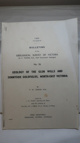
Document - Four Geological reports on the North-east Goldfields, Geological Survey of Victoria 1958 Bulletin
Geological Surveys of N.E. Goldfields Victoria included mines and tunnels. A resurvey of goldfields was necessary to re-assess economic possibilities using modern techniques and structural interpretation. It included an examination of a considerable surface area with maps and underground workings. Results were correlated and integrated and published by the Mines Department.The mines are in the Bogong Alpine Area.Foolscap printed Victorian Bulletins. Each stapled in the top left corner and each with varying number of pages. Covering 1941-1958 a) Glen Wills and Sunnyside b) Sunnyside Tunnel c) Red Robin d) Maud and Yellow Girl Government Printer, Mines Department, Melbourne, Victoriageology in the north-east, gold fields, goldmines, glen wills -
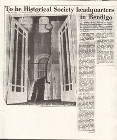 Bendigo Historical Society Inc.
Newspaper - DUDLEY HOUSE COLLECTION: HISTORICAL SOCIETY NEW HOME IN DUDLEY HOUSE, 1974
Article Bendigo Advertiser dated 28.8.1974, copy of newspaper, not original. Headline ' To be Historical Society Headquarters in Bendigo' Article discusses BHS move to Dudley House, View Street, Bendigo ' one of a group of Government buildings erected around Camp Hill towards the end of the 'fifties of last century'.bendigo, clubs, bendigo historical society -
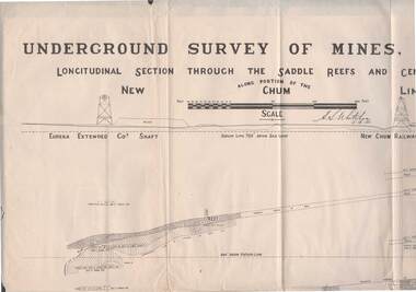 Bendigo Historical Society Inc.
Map - STRUGNELL COLLECTION: NEW CHUM LINE OF REEF, 5/4/01
Map, Along portion of the New Chum Line, Underground Survey of Mines, Bendigo, Longitudinal Section through the Saddle Reefs and Centre Country. Eureka Extended Co's shaft, New Chum Railway Co's shaft. Surveyed under the supervision of H.Herman, B.C.E., F.G.S., Acting Government Geologist.H.S.Whitelowmap, bendigo, new chum line -
 Bendigo Historical Society Inc.
Document - RAILWAYS COLLECTION: VICTORIAN GOVERNMENT GAZETTE, 25.3.1924
RAILWAYS COLLECTION -VICTORIAN GOVERNMENT GAZETTE -List of employees 25.3.1924 VICTORIAN RAILWAYS Aged , damaged paper Gazette -front pages is missing. The gazette shows Columns as follows - Departmental number, Name in full (Alphabetically), Position, Date of birth, Date of entry, Salary or rate of pay 1.1.23.document -
Whitehorse Historical Society Inc.
Article, Mayor pushes for council talks, 1994
Councilors from both City of Nunawading and City of Box Hill met with Local Government Board members last week to discuss the recommended merger of the two cities.Councillors from both City of Nunawading and City of Box Hill met with Local Government Board members last week to discuss the recommended merger of the two cities. It has been suggested by the Board that both Nunawading and Box Hill councillors meet as soon as possible to discuss the proposed merger.Councilors from both City of Nunawading and City of Box Hill met with Local Government Board members last week to discuss the recommended merger of the two cities. local government, city of nunawading, city of box hill, victoria. local government board, amalgamations -
Whitehorse Historical Society Inc.
Article, Tip top view of the city, 1994
Opening of the observation tower at old tip site.Opening of the observation tower at old tip site. Nunawading Apex Club joined forces with neighbouring clubs to construct it. The State Government and Nunawading Council have funded the project and Apex Club members have donated 2000 hours work over the last two years to complete the structure.Opening of the observation tower at old tip site.service clubs, nunawading apex club, secker, geoff, victorian government, city of nunawading, reeves, paul, waste transfer station, vermont south -
 Bendigo Historical Society Inc.
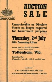
Document - IAN DYETT COLLECTION: AUCTION CATALOGUE - DEPARTMENT OF SUPPLY
Pale yellow auction catalogue for a sale of Unserviceable or Obsolete Stores no longer required for Government purposes on 2nd July, 1953 Under Instructions from Department of Supply. Columns on the right side of the page to write in the sale price. J. H. Curnow & Son Pty. Ltd. Were the auctioneers.business, auctioneers, j h curnow & son pty ltd, ian dyett collection - auction catalogue - department of supply, j h curnow & son pty ltd, hedges & bell pty ltd -
 Bendigo Historical Society Inc.
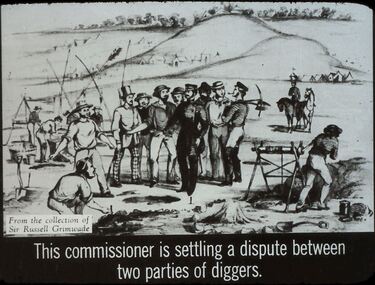
Slide - DIGGERS & MINING. THE GOLD LICENCE, c1850
Diggers & Mining. The gold licence. The Government Camp. Slide: This commissioner is settling a dispute between two parties of diggers. Slide also shows another officer and a number of mining sites, along with almost barren hills in the background. Markings: 8 994.LIF. 4. Used as a teaching aid.hanimounteducation, tertiary, goldfields -
 Bendigo Historical Society Inc.
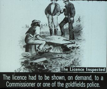
Slide - DIGGERS & MINING. THE GOLD LICENCE, c1850s
Diggers & Mining. The gold licence. The Government Camp. Slide depicts 2 miners, and a Commissioner inspecting their Gold Licence. S.T.G. art work. The Licence Inspected. The licence had to be shown, on demand to the Commissioner or one of the goldfields police. Markings: 29 994.LIF. 4. Used as a teaching aid.hanimounteducation, tertiary, goldfields