Showing 23748 items
matching sardine-creek
-
 Eltham District Historical Society Inc
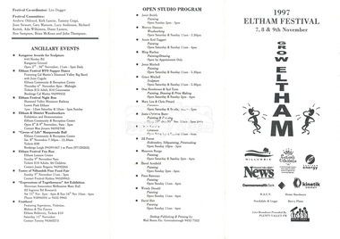
document - Folder, 1997 Eltham Festival, 1997
Folder Contents: 1. Program (A4 Trifold double sided) - 1997 Eltham Festival, 7, 8 & 9th November 2. Newsclipping: Festival reverts to its original name, Diamond Valley News, 21 May 1997 3. Eltham Festival returns, The Advertiser, Tuesday, May 20. 1997, p3 4. Festival funding down by $30,000, unidentified paper, 1997 (Also includes story "Play but no school" re fundraiser for Challenger St Pre-School at Diamond Creek held in the Diamond Creek Community Centre.. On reverse - "Bridges to be upgraded" by Laeta Antonysen regarding replacement of dilapidated bridges in Gipson Street, Diamond Creek)Miscellanous documents and newspaper clippings1997, eltham festival, program, challenger st pre-school, diamond creek community centre, george sartels, play school (tv show), bridge construction, gipston street, diamond creek -
 Kew Historical Society Inc
Photograph - Kew Main Drain, 1984
'Kew, Kew East, Balwyn & Balwyn North are located approximately 7km north east of Melbourne. Four main stormwater drains service the area flowing from south to north. Three of the drains: Deepdene Drain; Balwyn Drain & Glass Creek converge in Kew East just west of Burke Road at Kew High School before discharging into the Yarra River. The fourth drain, Kew Main Drain connects directly with the Yarra River to the West of Glass Creek.' The Kew Main Drain is a barrel drain that was created in the 1930s, and follows the route of the former Connor's Creek from the vicinity of Genazzano FCJ College to the Yarra River in East KewImportant and verifiable evidence of the construction methods used by the Melbourne & Metropolitan Board of Works in building the Kew Main Drain, before its reconstruction in c.1985.Original print colour positive photograph of the Kew Main Drain, provided on 14/12.84 to the Chief Engineer of the City of Kew, Ian Poulter, by the Supervising Engineer (Works), Southern and Eastern Drainage, Melbourne & Metropolitan Board of Works. The record includes an image of the reverse as well as the donation document from the MMBW."A84/1855-9 / 750mm council drain looking D/S [down stream] and across Parkhill Road. To be replaced with 1200 mm R.C.P. [reinforced concrete pipe] as part of MMBW Kew Main Drain reconstruction works"kew main drain, stormwater drains -- kew (vic.), connor's creek -- kew (vic.) -
 Kew Historical Society Inc
Photograph - Kew Main Drain, 1984
'Kew, Kew East, Balwyn & Balwyn North are located approximately 7km north east of Melbourne. Four main stormwater drains service the area flowing from south to north. Three of the drains: Deepdene Drain; Balwyn Drain & Glass Creek converge in Kew East just west of Burke Road at Kew High School before discharging into the Yarra River. The fourth drain, Kew Main Drain connects directly with the Yarra River to the West of Glass Creek.' The Kew Main Drain is a barrel drain that was created in the 1930s, and follows the route of the former Connor's Creek from the vicinity of Genazzano FCJ College to the Yarra River in East KewImportant and verifiable evidence of the construction methods used by the Melbourne & Metropolitan Board of Works in building the Kew Main Drain, before its reconstruction in c.1985.Original print colour positive photograph of the Kew Main Drain, provided on 14/12.84 to the Chief Engineer of the City of Kew, Ian Poulter, by the Supervising Engineer (Works), Southern and Eastern Drainage, Melbourne & Metropolitan Board of Works. The record includes an image of the reverse as well as the donation document from the MMBW."A84/1855-10 / 750mm council drain looking U/S [up stream] from Parkhill Road, Kew."kew main drain, stormwater drains -- kew (vic.), connor's creek -- kew (vic.) -
 Eltham District Historical Society Inc
Photograph, Fay Bridge, Centenary celebration, Monash Bridge, Hurstbridge, 7 November 2017
The area of Hurstbridge was originally known as Hurst’s-bridge after the timber bridge built over the Diamond Creek near Hurst’s station in late 1881/early 1882. It was replaced by a new concrete bridge designed by Sir John Monash over the Diamond Creek near Hurst's home of 'Mia Mia' at Hurstbridge. The official opening of the new Monash bridge at Hurstbridge was held 3 November 1917.fay bridge collection, 2017-11-07, hurstbridge, hurstbridge heritage trail, monash bridge, ruins -
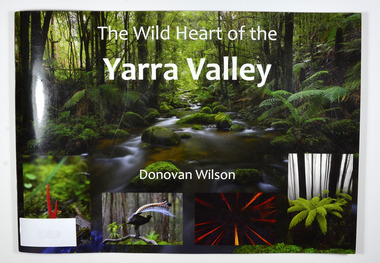
 Marysville & District Historical Society
Book, The Wild Heart of the Yarra Valley, Unknown
A pictorial book of the flora, fauna, rivers, waterfalls and rainforest in the Upper Yarra ValleyPaperback. Front cover has a main photograph of a creek running through a forest. There is also four smaller photographs. They are of a Red Coral Fungi, a Superb Lyrebird, a night time view looking upwards in a grove of trees and a view of a Soft tree fern. The back cover has a photograph of a Superb Lyrebird.yarra valley, upper yarra valley, flora, fauna, photography, rivers, waterfalls, rainforest, nature, donovan wilson -
 Glenelg Shire Council Cultural Collection
Photograph - Photograph - Bridge, n.d
Sourced from Casterton Town Hall (former Shire of Glenelg)Coloured photograph. Same as 7302 7302 - Coloured photograph. Unmade road between paddocks. Photo taken close to bridge with wooden railings. Erosion of creek sides can be seen. Sign at bridge ' Bridge Load Limit 5 t gross'? Same bridge as 7301, taken at different time. -
 Federation University Historical Collection
Document, Ken Clements, Peterborough Puzzles, 2009, 2009
Massacre Bay is located on Victoria's Great Ocean Road, and is in the centre of the Bay of Martyrs. The bay consists of 20 m high, red limestone bluffs. This paper by Ken Clements considers the origin of the term martyr in connection to this location, and where the Aboriginal massacre may have taken place. Thirteen page document by Ken Clements relating to Peterborough, Victoria. Contents include coastal features, local Aborigines, Bay of Martyrs, Massacre Bay, Massacre Hill, Buckley Creek Run, Pioneer Pastoralists, British Traversers, settlers, Peterborough, Maps, tourism, history method. Photographs by Laurie Moore.aborigines, bay of martyrs, massacre bay, massacre hill, buckley creek run, pioneer pastoralists, british traversers, settlers, peterborough, maps, tourism, history method, childers cove, barque children, murnane bay, sandy bay, dog trap bay, buckley creek, viviennes lookeout, stanhope bay, buttres bay, burnies beach, armstrong creek, flaxman hill, antares rock, lovers nook, crofts bay, clements, worm bay, halladale point, the well, wold dog cove, james irvine monument, curdies inlet, squirrel creek, wallaby creek, boggy creek, whiskey creek, pioneer beach, schomberg rock, young australia, spit, crown of thorns, newfield bay, the grotto, london bridge, point hesse, high cliffs, the arch, cape martyr, little massacre bay, aboriginal massacre, ken clements -
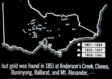 Bendigo Historical Society Inc.
Slide - DIGGERS & MINING. THE GOLD ERA, c1851
Diggers & mining. But gold was found in 1851 at Anderson's Creek, Clunes, Buninyong, Ballarat, and Mt. Alexander, - - - Slide shows map of Victoria with legend to show when gold was found in different areas. The gold era. Markings 4 994.031 GOL:5. Used as a teaching aid. Used as a teaching aid.hanimounteducation, tertiary, goldfields -
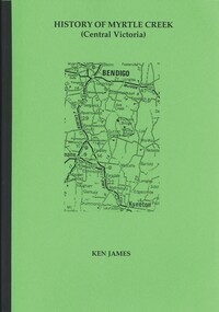 Bendigo Historical Society Inc.
Book - HISTORY OF MYRTLE CREEK, CENTRAL VICTORIA, 2005
HISTORY OF MYRTLE CREEK, CENTRAL VICTORIA - 192 pages with photos, illustrations and maps. Letter inside from Ken James, 18 Lofty Avenue, Camberwell, 3124. 17/10/05. Inscribed on front fly page ' Donated to the Bendigo Historical Society Inc. by Ken James Oct. 2005.'Ken Jameshistory, myrtle creek, myrtle creek, cockatoo creek, state schools, ken james, gold mining, quartz mining -
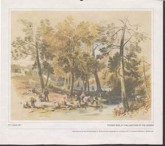 Bendigo Historical Society Inc.
Painting - CAROL HOLSWORTH COLLECTION: 1970 NATIONAL BANK PAINTING 'FITZROY BAR AT THE JUNCTION OF THE CREEKS'
1970 National Bank painting reproduction Fitzroy Bar, at the junction of the creeks by G.F. Angas 1851 Below the picture title the words - Reproduced by the National Bank in 1970 from the lithograph by courtesy of Dr. E. Graeme Robertson , Melbourne .At the foot of the painting are the words Gold Washing and Fitzroy Ophir diggingspainting, watercolour, g.f. angas 1851/ -
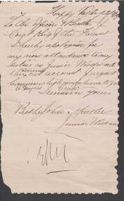 Bendigo Historical Society Inc.
Document - ANCIENT ORDER OF FORESTERS NO. 3770 COLLECTION: CORRESPONDENCE
A letter of apology from John Mueller to Court King of the Forest apologising for his non attendance to his duties as Junior Woodward as he had urgent business which compelled him to go to Myers Creek. Three edges of letter have been trimmed wirh scallop shaped scissors.societies, aof, correspondence, ancient order of foresters no. 3770 collection - correspondence, court king of the forest, john mueller -
Bendigo Historical Society Inc.
Map - TANDARRA : COUNTY OF BENDIGO, 14-3-24
Map. Tandarra, County of Bendigo, Talambe, Yallook, Neilborough, Whirrakee, Kamarooka. Photo-Lithographed at the Department of Lands and Survey, Melbourne by W.J. Butson,14-3-24. Price 1/-.Myers Creek, Tandarra Estate. By authority Mullett, Government Printer, Melbourne. (number 24 in map cupboard 1)Albert J. Mullett, Government Printer, Melbourne.map, bendigo, tandarra -
 Bendigo Historical Society Inc.
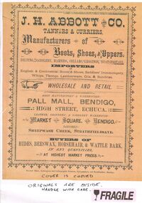
Document - J.H.ABBOTT & CO
Document, Multi Pages of Advertising J.H.Abbott & Co.,Tanners & Curriers, Manufacturers of Boots, Shoes, Uppers, Belting.Saddlery, Harness, Collars, Leggings, Neatsfoot Oil. Importers of English & Continental wares. Wholesale and Retail, Pall Mall, Bendigo; High Street Echuca: Market Square, Bendigo; Sheepwash Creek, Strathfieldsaye.Bolton Bros.,Bendigo.document, names of bendigo pioneers, j.h.abbott -
 Bendigo Historical Society Inc.
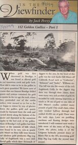
Newspaper - JACK PERRY COLLECTION: NEWSPAPER GOLDEN GULLIES PART 1
Newspaper article Bendigo Weekly re Golden Gullies in Bendigo. Information regarding Peg Leg Creek, Lougsons hydraulic sluice Myers Flat, Peg Leg Gully. Photo of Mr. Lougsons hydraulic sluice of Myers Flat in the 1930's.. Recovering gold from Peg Leg Gully.Bendigo Advertiser 3.9.99person, individual, jack perry, peg leg gully, catherine, saxby, eaglehawk gully. -
Bendigo Historical Society Inc.
Map - AXEDALE, COUNTIES OF BENDIGO & RODNEY, 1961
Map, Axedale, Counties of Bendigo & Rodney.Axe Creek, Campaspe River, Longlea Railway Station, Axedale Railway Station, Wallan & Bendigo Railway.Township of Axedale. By authority A.C.Brooks, Govt. Printer, Melbourne.Drawn and reproduced at the Dept. of Lands and Survey, Melbournd. Price 1/-. 1961. (number 61 in map cupboard 1)A.C.Brooks, Government Printer, Melbourne.map, bendigo, axedale -
Bendigo Historical Society Inc.
Map - CROSBIE : COUNTY OF BENDIGO, 28-9-76
Map. Crosbie, County of Bendigo, County of Rodney, Mt. Pleasant Creek, Weston, Toolleen, Redcastle, Dargile, Knowsley East. W.E. Porter, draughtsman, August 1878. Photo-Lithographed at the Department of Lands and Survey, Melbourne, J. Noune,28-9-76. (number 113 in map cupboard 1)W.E. Porter, Draughtsmanmap, bendigo, crosbie -
 Bendigo Historical Society Inc.
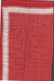
Clothing - ANNE BRONSDON COLLECTION: NECKERCHIEF
ANNE BRONSDON COLLECTION NECKERCHIEF neckerchief -one of two which were the property of Anne Bronsdon ' grandfather Jan du Marchie Sarvaas who died at Emu creek in 1877. Red cloth neckerchief (dotted white spotted ) with red and white, borders .Some stains 53x 53 cmpersonal effects, jan du marchie sarvaas -
 Bendigo Historical Society Inc.
Document - MCCOLL, RANKIN AND STANISTREET COLLECTION: NORTH DEBORAH MINE/WHIPPET MINE TENNANT CREEK, 1949
Document: MCCOLL, RANKIN AND STANISTREET - brown card folder containing correspondence and legal opinions regarding the purchase of shares in the Whippet Mine at Tennant Creek by the board of the North Deborah Mining NL. Written on cover ' re Rubinstein indemnity Whippet shares' stamped ' North Deborah Gold Mine NL'.organization, mining, mccoll, rankin and stanistreet, mccoll, rankin and stanistreet, goldmining, north deborah mine , whippet mine -
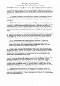 Bendigo Historical Society Inc.
Document - TEXT OF TALK BY GEOFF RUSSELL ''FIXING BENDIGO'S BIG STINK'' (27/5/2005)
Text of illustrated talk to BHS (27/5/2005) by Geoff Russell ''Fixing Bendigo's Big Stink'' Three pages covering the drainage and sewerage problems and solutions of Bendigo (and creeks) in the period from the early 1850s through to the 1920s. (Note: no images). Bendigo Sewerage Authority (BSA) inaugurated 1917.document, names of bendigo pioneers, bendigo's sewer scheme, bendigo sewer. s. gordon moore. cr james curnow. william beebe. -
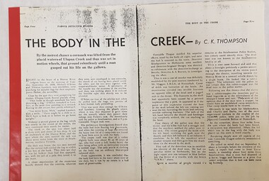 Numurkah & District Historical Society
Ulupna Island murder
These are stories are related to the murder at Ulupna Island, 1898a. Photocopy from Famous Detective Stories "The Body in the Creek" (Stapled at the side, with red binding tape) b. Photocopy from Famous Detective Stories "Death Stalks the Redgums" (Stapled at the side, with red Binding Tape c. Famous Detective Stories magazine Volume 1 No. 6 May 1947as per photos aboveulupna island, murder, crime, detective stories, police, redgum forest -
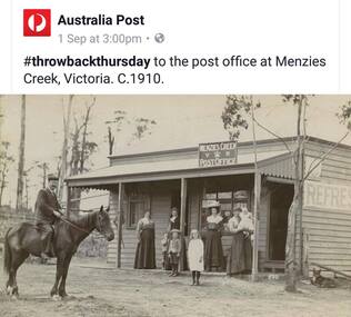 Southern Sherbrooke Historical Society Inc.
Photograph - Australia Post social media image, Menzies Creek post office c.1910
Colour photograph of a social media post from Australia Post. Photo is of people standing in front of the Menzies Creek Post Office, circa 1910. A man on a horse is on the left. Four women and four children stand in front of the building. This was used for a series of stamps celebrating Australia Post's 200th anniversary. -
 Ballarat Tramway Museum
Photograph - Digital image, Dave Macartney, c1969
Digital Image of MMTB tram W5 836 inbound in Mt Alexander road, just before the crossing of Moonee Ponds Creek. Tram is freshly painted, showing City Route 59. In the background is a Holden car dealer, the railway bridge over Flemington Road. Photo by Dave Macartney 1969?trams, tramways, w5 class, mt alexander road, tram 836 -
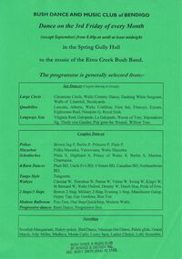 Bendigo Historical Society Inc.
Document - PETER ELLIS COLLECTION: BUSH DANCE AND MUSIC CLUB
Green poster advertising the Bush Dance and Music Club of Bendigo at the Spring Gully Hall. Music by the Emu Creek Bush Band. The programme consisted of Set Dances, Couples Dances and Novelties. Stamped at the bottom of the page is Bush Dance & Music Club of Bendigo & District Inc. Sec. Mary Smith.entertainment, dance, bush dance, peter ellis collection, bush dance and music club of bendigo, emu creek bush band, mary smith -
 Bendigo Historical Society Inc.
Document - LUCY HILL COLLECTION: INCIDENTAL INDUSTRIES OF MINING
Typed notes mentioning industries of mining. Items mentioned are: Chief burners or pyrites works chlorination and cyaniding and gives a description of each process. Also mentioned in the notes is the Obelisk at Golden Square as a memorial to the pioneers and Mrs Kennedy and Mrs Farrell who found gold on the Bendigo Creek. Two Copiesdocument, gold, industries, lucy hill collection - incidental industires of mining, pyrites works, cyaniding, obelisk at golden square, united pyrites co, edwards and co, cook and co, spargo and co, j deeble, liddle bros, the jackass flat burner, a victor leggo, cr j e holland, mrs polglais, mrs kennedy, mrssrs fenton and gibson, mount alexander run, mrs farrell, bendigo advertiser -
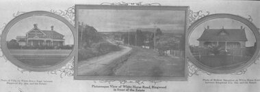 Ringwood and District Historical Society
Photograph, Strip of images used for Ringwood Heights Estate land sale promotion - 1924
Strip of 3 views apparently part of a land sale advertisement - View of Whitehorse Rd between photos of two Whitehorse Rd houses.Typed on back of photographs, "Ringwood Heights Estate. Land on left of road and down to Mullum Creek. Sold by T. Grant. 97 lots, 1st March 1924. J.B. McAlpin, agent. No deposit, 1 pound per month." -
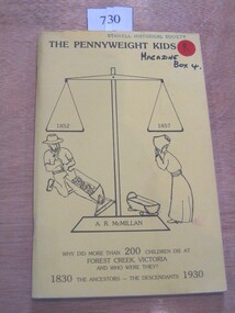 Stawell Historical Society Inc
Book, A. R. McMillan, The Pennyweight Kids - 1852-1857, 1988
The Story of the children who lived and died with the killer diseases of the last century (1800's). Theere is a preservation order now on force to restore the cm=emetary.Yellow Card Cover with black in drawing of Large balance scale. A Miner slucing gravel to the left and a woman looking at an empty cradle to the rightThe Pennyweight Kids 1852 1857 A.R. McMillan Why did more than 200 children die at Forest Creek Victoria and who were They? 1830 The Ancestors - The Descendants 1930 Inside: To The Stawell Historical Society from the Authorcastlemaine -
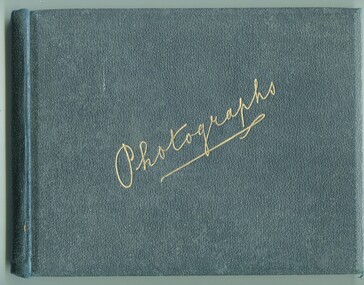 Orbost & District Historical Society
photograph album, James, Harry, 1900 - 1910
Photographs in this album are : forest,creek; Burns Cutting; river with bridge; Tony in his boat (spare print); Murrungowar and three of Conran.Henry James (1860-1932) was a well-known identity in the Orbost district.He was a stock agent and auctioneer who helped to establish the seed bean industry in Orbost. He was the second secretary of the Snowy River Shipping Co. as well as a shire councillor and prominent member of MUIOOF.a fabric covered book with gold print - "Photographs" on front cover. It contains an assortment of photographs.inside front cover - "Photographs taken by Mr Harry James about 1900-10"james-harry photography-orbost-conran-murrungowar -
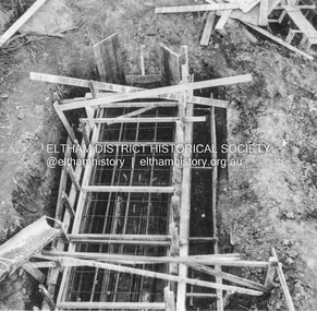 Eltham District Historical Society Inc
Album - Photograph, J.A. McDonald, Eltham-Greensborough Road, 26 July 1956
Diamond Creek Bridge (Bridge Street Bridge) Showing tremie used upstream cylinder pier No. 1 26th July 1956.Record of various Shire of Eltham infrastructure works undertaken during the period of 1952-1962 involving bridge and road reconstruction projects, sometimes with Eltham Shire Council Project Reference numbers quoted. It was during this period that a number of significant improvements were made to roads and new bridges constructed within the shire that remain in place as of present day (2022). In many situations, the photos provide a tangible visible record of infrastructure that existed throughout the early days of the Shire. The album was put together by or under the direction of the Shire Engineer, J.A. McDonald.infrastructure, road construction, shire of eltham, bridge construction, bridge street bridge, eltham, eltham-greensborough road, 1956-07-26 -
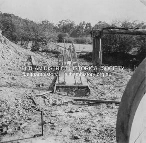 Eltham District Historical Society Inc
Album - Photograph, J.A. McDonald, Eltham-Greensborough Road, 1957
Diamond Creek Bridge (Bridge Street Bridge) Greensborough abutment – Piles broken back and false floor poured for columns 1957Record of various Shire of Eltham infrastructure works undertaken during the period of 1952-1962 involving bridge and road reconstruction projects, sometimes with Eltham Shire Council Project Reference numbers quoted. It was during this period that a number of significant improvements were made to roads and new bridges constructed within the shire that remain in place as of present day (2022). In many situations, the photos provide a tangible visible record of infrastructure that existed throughout the early days of the Shire. The album was put together by or under the direction of the Shire Engineer, J.A. McDonald.infrastructure, road construction, shire of eltham, bridge construction, bridge street bridge, eltham, eltham-greensborough road, 1957