Showing 23748 items
matching sardine-creek
-
 Eltham District Historical Society Inc
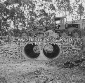
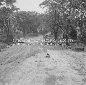
Album - Photograph, J.A. McDonald, Heidelberg-Kinglake Road, May 1957
Wild Dog Creek (Day Labour) 56M346 Two rows 6’0” pipe May 1957 Showing culvert and stone wallsRecord of various Shire of Eltham infrastructure works undertaken during the period of 1952-1962 involving bridge and road reconstruction projects, sometimes with Eltham Shire Council Project Reference numbers quoted. It was during this period that a number of significant improvements were made to roads and new bridges constructed within the shire that remain in place as of present day (2022). In many situations, the photos provide a tangible visible record of infrastructure that existed throughout the early days of the Shire. The album was put together by or under the direction of the Shire Engineer, J.A. McDonald.infrastructure, shire of eltham, bridge construction, heidelberg-kinglake road, road construction, 1957-05, wild dog creek -
 Eltham District Historical Society Inc
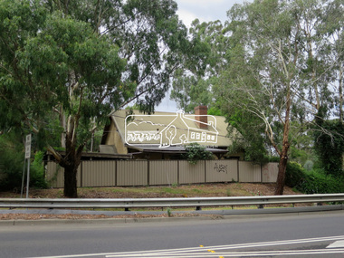
Photograph, Jim Connor, Main Road, Eltham, 14 Jan 2017
Eltham Gateway, View of 43 Antoinette Boulevard from Main Road at the approaches of the Main Road Bridge over the Diamond CreekTomorrow's history documented todayeltham, jim connor collection, main road, eltham gateway -
 Eltham District Historical Society Inc
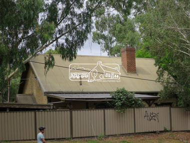
Photograph, Jim Connor, Main Road, Eltham, 14 Jan 2017
Eltham Gateway, View of 43 Antoinette Boulevard from Main Road at the approaches of the Main Road Bridge over the Diamond CreekTomorrow's history documented todayeltham, jim connor collection, main road, eltham gateway -
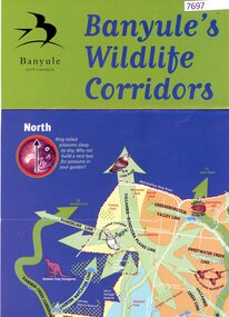 Greensborough Historical Society
Poster, Banyule City Council, Banyule's wildlife corridors, 2000c
This poster shows the habitat and wildlife corridors within the City of Banyule, including the Darebin Creek catchment and Plenty and Yarra river catchments.Colour poster, folded, printed on bot sides.native fauna, wildlife corridors, wildlife habitat -
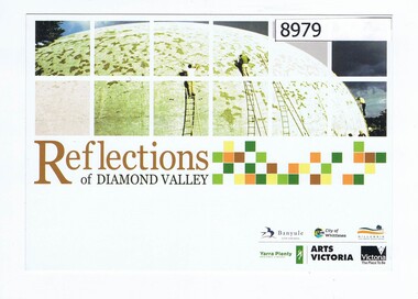 Greensborough Historical Society
Postcard, Reflections of Diamond Valley, 1979
This postcard depicts the Diamond Creek Community Centre (Bini Shell) during its construction in 1979. It is part of the YPRL image collection. Colour postcardyarra plenty regional library, arts victoria, diamond creek, bini shell diamond creek -
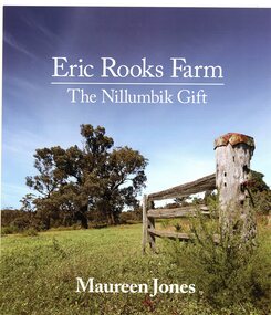 Greensborough Historical Society
Book, Maureen Jones, Eric Rooks Farm: the Nillumbik gift; by Maureen Jones, 2022
Eric Rooks bequeathed his family property in Diamond Creek to the National Trust as a gift to the people of Nillumbik. The property is in Allendale Road.93p., illus,. (some col.)diamond creek, eric rooks, maureen jones, nillumbik -
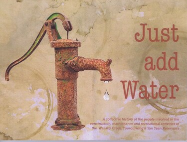 Greensborough Historical Society
Book, Friends of Toorourrong Inc, Just add water, 2019_
History of the people and organisations associated with the Yan Yean and Toorourrong Reservoirs, and with Wallaby Creek compound. Book launch report by Anne Paul.Paperback book, 109 p., colour and black and white photographs. And a 1 page typed report on the book launch.yan yean reservoir, water supply, toorourrong reservoir -
 Greensborough Historical Society
Photograph - Digital image, Eddie Smith at Sutherland Homes, 1956c
Black and white photograph or Eddie (Edmond) Smith at Sutherland Homes in Diamond Creek. Eddie's story can be read in "The Silver Poplar".Black and white digital photographedmond smith, sutherland homes for children -
 Greensborough Historical Society
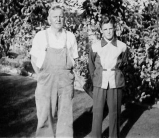
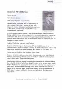
Article, Greensborough Historical Society et al, Benjamin Alfred Starling, 1914-1918
A short article about Benjamin Alfred Starling and his service in World War 1. Ben Starling was born in Diamond Creek. .2 pages, text and colour images.world war 1 project, benjamin alfred starling -
 Greensborough Historical Society
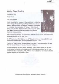
Article, Greensborough Historical Society et al, Walter David Starling, 1914-1918
A short article about Walter David Starling and his service in World War 1. Walter Starling was born in Diamond Creek. .2 pages, text and colour images.world war 1 project, walter david starling -
 Greensborough Historical Society
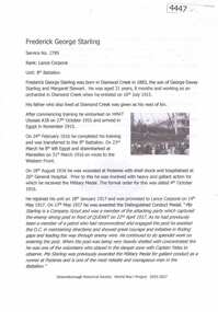
Article, Greensborough Historical Society et al, Frederick George Starling, 1914-1918
A short article about Frederick George Starling and his service in World War 1. Fred Starling was born in Diamond Creek. .2 pages, text and colour images.world war 1 project, frederick starling -
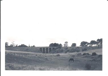 Hume City Civic Collection
Photograph, pre 1970
The five arch bridge spans Blind Creek in Sunbury. The bridge is at the start of one of the longest and steepest inclines on a railway track in Australia.A black and white photograph of the 5 arch railway bridge and surrounding open area near Rupertswood. The tower of Ruppertswood can be seen in the distance.railway bridges, rupertswood, bridges, george evans collection -
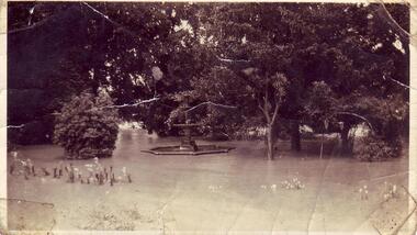 Clunes Museum
Photograph - PHOTOGRAPH FLOODS 1934
AFTER HEAVY RAINS - CRESWICK CREEK IN CLUNES TOWNSHIP FLOODED, OVER FLOWING ITS BANKS, NEAR BY AREAS WERE SUBMERGED.BLACK AND WHITE SMALL PHOTOGRAPH OF CLUNES FLOODS IN 1934. CLUNES QUEEN'S PARK WITH FOUNTAIN UNDER WATER - TREES IN THE BACKGROUND AND A FEW FLOWERS IN THE FOREGROUND.local history, queen's park garden., floods 1934 -
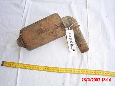 Friends of Kurth Kiln
Assembly,mid 1940
Kurth's kiln used creek water in a series of waterpipes to cool the charcoal below the flash point for extraction during the charing processA cylinder of wood fitted on a 1" waterpipe, secured by an elbow and a 1" locknut. A 10cl long piece of pipe is fitted on the other side of the elbow. The assembly could be part of the kiln water-cooling system -
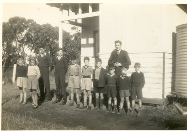 Heytesbury District Historical Society Inc.
Photograph - Eastern Creek SS Teacher and pupils C. 1942
Black and white photograph of pupils and teacher (Jim Crowley) outside the Eastern Creek SS. No 4595 Families include Giblett, Webb, Black and White photographeastern creek, school, education -
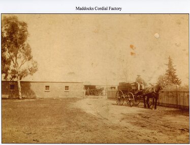 Stawell Historical Society Inc
Photograph, Mr J. McDougall’s Stawell Aerated Water Cordial Factory 1912
Photo of painting of J. McDougall’s Aerated Water Cordial Factory 1869. (Maddocks) Stawell. Opposite old Pleasant Creek Hospital.stawell industry -
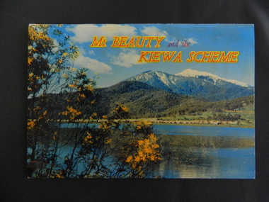 Kiewa Valley Historical Society
Booklet - Mt Beauty and the Kiewa Scheme x2
This booklet was produced to advertise Mt Beauty, the Kiewa Scheme & surrounding areas to visitors / tourists. The photos cover Falls Creek with snow, lifts and skiers - one with Spion Kopje Lodge. Also Tawonga Camping ground, Bogong Village, Mt Beauty Chalet, the Control panel at Kiewa Power Station, Clover Dam at No. 3 Power Station, the road to Falls Creek and a view of Mt Beauty township. The photos indicate what Mt Beauty and the Kiewa Valley and High Plains looked like c1950's during the construction of the Kiewa Hydro Electric Scheme. The area was recognised and encouraged as a tourist attraction especially Falls Creek enabling comparison with later photos and ideas. A fold down booklet postcard size of 12 colored photos - back to back of Mt Beauty, the Kiewa Scheme & surrounds. They fold in to form a front photo with title and a back card for stamp & address of addressee. On the back of the front photo are a few paragraphs describing the beauty, history and 'things to do' in the area for the visitor / tourist. mt beauty; kiewa scheme; tawonga; bogong; clover dam; kiewa valley; bogong high plains -
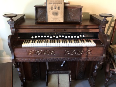 Mont De Lancey
Organ, The Cornish Company, Circa 1880's
This "Cornish" organ was imported by Thomas Sebire of Wandin in 1911. In 1942 it was bequeathed to his daughter, Edna (Mrs. G. Andrews of Wandin) and by her to her daughter, Beverly (Mrs. L.D. Creek of Nhill) in 1971. Mrs Creek has made this organ available for the Wandin Historical Display. Mrs. G. Andrews was organist of the Wandin Methodist Church from 1927 to 1942. Owned and used by Thomas Sebire.Pump organ with pedals. Has carved decoration on front and sides."Cornish Company, Washington New Jersey USA"harmoniums, organs -
 Falls Creek Historical Society
Clothing - Women's Ski Wear 1970s
This outfit was donated by Hayley Martin. It was worn by two generations of the family, Hayley's mother and later by Hayley herself. Throughout the 1960s and early 1970s the six members of the Martin Family generally spent at least a week each year at Falls Creek, staying at Spargo's Lodge. The Martins then bought a share in Diana Lodge and stayed there frequently until the late 1970s. The sweater (HEAD brand) was purchased at Molony's at Falls Creek.This item is significant as it is indicative of the apparel worn by skiers at Falls Creek in the 1960s and 1970s.Black woollen stretch pants with white line pattern. A woollen cap completes the outfit.women's ski attire, molony ski shop, cuming's ski hire -
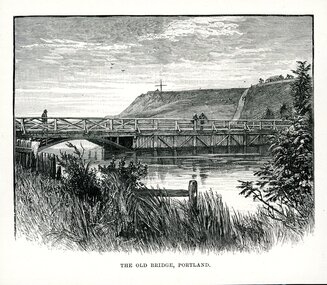 Glenelg Shire Council Cultural Collection
Artwork, other - Illustration, THE OLD BRIDGE, PORTLAND, n.d
Illustration. Taken and cut from a book. View of bridge across Salt Creek. Bridge has the appearance of being timber and features to the left of the bridge a half arch opening through to the other side of the creek. 3 people are on the bridge. Fore ground has part of a fence visible through long grass and some shrubbery. Observatory Hill in background with a large cross structure on the top to the left. A road or path is visible up the side of the hill towards a dwelling with a panel fence and trees. Two people are on the path and what appears to be 3 sheep to the left of them grazing on the hill. Sky appears cloudy with 3 birds flying. Underneath is written THE OLD BRIDGE, PORTLAND.portland victoria -
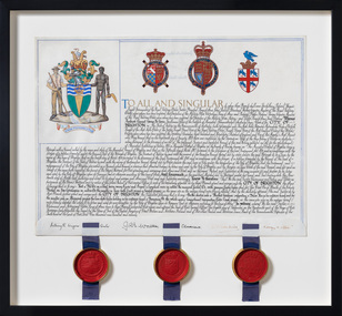 Bayside Gallery - Bayside City Council Art & Heritage Collection
Document - Certificate, College of Arms, City of Brighton Coat of Arms, 1970
The Coat of Arms, represents Brighton City Council's "growing awareness of the importance of formality and correct symbolism in local government". It replaced the council's crest of a pier and yachting scene and was used as council's seal, emblem on its flag and letterhead. The new Coat of Arms, drawn up by the College of Arms in England, depicts the progression from a seaside gardening community to a modern residential city. The prominent forms are on the shield-like coat of arms include waves and a Lymphad (a ship, symbolic of the sea); a market gardener; an aboriginal man; two horns plenty with abundant fruit and vegetables (the wealth and plenty) and Elster Creek (now Elster Canal). It is underscored by the motto "By their fruits, ye shall know them". Brighton was first incorporated as a borough on 18 January 1859, it became a town on 18 March 1887 and was proclaimed a city on 12 March 1919.Ink and gouache on parchment with wax seals. Allocates a Coat of Arms to the City of Brighton, by the College of Arms in London on 08/09/1970. The Coat of Arms is located on the upper left quadrant and has the following parts: the crest, the wreath, the helmet and mantle, the shield, the supporters, the compartment and the motto. The crest is two cornucopias with fruits and vegetables, above which sits a seagull. The mantle above the helmet is in green and gold. The shield is also green and gold with a lymphad (ship), and blue and white waves, representing the sea. The market gardener, holding a hoe, and Aboriginal figure, bearing a boomerang, support the shield and stand upon the compartment which is soil with a representation of Elster Creek. A ribbon below contains the motto in 'FRUCTU NOSCITUR'. The certificate text explains the origins of Brighton and the parts of the coat of arms. At the bottom of the folded parchment are three signatures and titles, below which three red wax seals in gold tin containers hang from blue ribbons.coat of arms, certificate, city of brighton, college of arms, market gardener, aboriginal, wax seal, elster creek, lymphad, fructu noscitur, letters patent, armorial bearings, heraldry, seal -
 Ringwood and District Historical Society
Book - Eureka Plan, Farmer, Mr, Eureka Plan, c. 1930
Created to assist in promotion and sale of land near Ringwood Railway station, following completion of the electric rail to Ringwood..Book containing details of seven delightful and valuable Ringwood properties - Bestpart, Paradur, Hill Top, Greenwood, Creek, Station and School estates. The book has 16 photos and 20 plans and 20 pages. There are multiple copies of pages 20x2; 19x2; 18x4; 17x4 and 20x2. +Additional Keywords: Farmer, Mr -
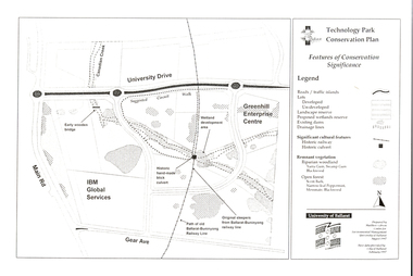 Federation University Historical Collection
Document - Plan, Mathew Gibson, Centre for Environmental Management, Ballarat Technology Park Conservation Plan, 1997, 1997
The Ballarat Technology Park is on the Mount Helen Campus.A4 photocopy of a plan of the Ballarat Technology Park showing features of conservation significance. The plan includes the Canadian Creek, an historic hand-made brick culvert, Canadian Wetland Development, early wooden bridge, old path of the Ballarat-Buninyong Railway line, Greenhill Enterprise Centre and IBM Global Services.ballarat technology park, greenhill enterprise centre, ibm global enterprises, ballarat-buninyong railway line, canadian wetlands, brick railway culvert, canadian creek, riparian woodland, yarra gum, swamp gum, blackwood, remnant vegetation, scent bark, narrow-leaf peppermint, messmate, centre for environmental management, mount helen campus -
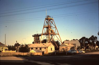 Bendigo Historical Society Inc.
Slide - HORWOOD COLLECTION: CENTRAL DEBORAH, c1965
Horwood Collection. Central Deborah Gold Mine Violet Street Bendigo. Poppet head has flagpole. Shed for winding machine is off to the right on the creek side, change rooms are along side fence and office is in front of the poppet head. Markings: Central Deborah High Street Bendigo 16 OCT65MKodakmine, gold, central deborah gold mine, horwood collection. central deborah gold mine violet street bendigo. poppet head flagpole. shed for winding machine to right on creek side, change rooms side fence office front poppet head -
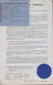 Bendigo Historical Society Inc.
Document - GILBERT RULE COLLECTION: SANDHURST CEMETERY BACK CREEK AGREEMENT, 1875
Gilbert Rule Collection: receipt and agreement from trustees of Sandhurst Cemetery Back Creek to dig a grave. Receipt for purchase of ground from John Rule the sum of two pounds for purchase of ground eight feet by four feet. Receipt dated September 18th. 1875. Agreement 19th. November, 1875.Sandhurst Cemetery Trustperson, individual, gilbert rule -
 Bendigo Historical Society Inc.
Negative - ALEXANDRA FOUNTAIN, CITY FAMILY HOTEL, VIEW POINT
Negative of line drawing of Alexandra fountain in foreground, City Family Hotel in background, on RH side View Point. On LH side, hansom cabs lined up alongside Bendigo Creek. Man standing leaning on fence around fountain. Appears to be late 1800's ? Negative is damaged with patches of damage.bendigo, streetscape, view point, alexandra fountain, bendigo city family hotel, alexandra fountain, hansom cab -
Bendigo Historical Society Inc.
Map - WOODSTOCK : COUNTY OF BENDIGO, 4-7-35
Map. Woodstock, County of Bendigo, Derby, Leichardt, Marong, Shelbourne, Laanecoorie, Tarnagulla. Bradford Creek, Maldon and Laanecoorie Railway. Drawn and reproduced at the Department of Lands and Survey, Melbourne, Victoria.4-7-35. Price 2/-. By authority H.J. Green,Govt. Printer. (number 41 in map cupboard 1)H.J. Green, Govt. Printer.map, bendigo, woodstock -
Bendigo Historical Society Inc.
Map - ELLESMERE, COUNTY BENDIGO, 17-3-16
Map, Ellesmere, County Bendigo, Goornong, Bagshot, Muskerry, Wellsford, Axedale, Township of Fosterville.Campaspe River, Bendigo Creek, Railway Line.Photographed at the Dept. of Lands and Survey, Melbourne by W.J.Butson 17-3-16.Price 1/-. By authority Albert J.Mullett, Government Printer, Melbourne. ( number 38 in Map Cupboard 1)Albert J.Mullett, Govt. Printer, Melbourne.map, bendigo, ellesmere -
Bendigo Historical Society Inc.
Map - RUNNYMEDE : COUNTY OF BENDIGO, 8-12-13
Map. County of Bendigo, County of Rodney, Burnewang, Elmore, Nolan, Campaspe, Colbinabbin, Burramboot, Corop, Township of Runnymede, Campaspe River, Mount Pleasant Creek. Photo-Lithographed at the Department of Lands and Survey, Melbourne by W.J. Butson.8-12-13. Price 1/-. (number 107 in map cupboard 1)W.J. Butsonmap, bendigo, runnymede