Showing 815 items matching " aerial views"
-
 Lakes Entrance Historical Society
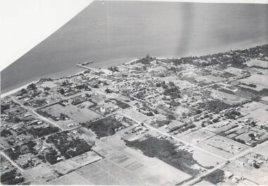
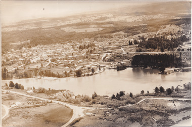
Photograph - Lakes Entrance, Bulmer H D, 1940c
... Black and white photograph of aerial view of township...Waterways Township Black and white photograph of aerial ...Black and white photograph of aerial view of township. It shows route of Princes Highway through town, turning north at Myer Street and continuing along Roadknight Street. Few jetties on North Arm, many on Cunninghame Arm. In far upper left of image sea is breaking on sand hummocks. Lakes Entrance Victoriawaterways, township -
 Greensborough Historical Society
Photograph - Digital image, Frank Solomon, Pig Farm, Weidlich Road area: aerial view, 02/08/2009
... Pig Farm, Weidlich Road area: aerial view...An aerial view of the pig farm in Weidlich Road... Plenty Lower Plenty melbourne An aerial view of the pig farm ...An aerial view of the pig farm in Weidlich Road Greensborough, owned by Werner Hanusch. The land was used as a pig farm and quarry from 1954 and has now been subdivided into the Evelyn Way estate. This project of fifty, one double storey, dwellings was commenced on 2/8/2009 and completed on 6/2/2011.An example of the changing land use in Greensborough, from farming to residential.Digital copy of aerial photographwerner otto fritz hanusch, pig farm st helena, weidlich road greensborough, one evelyn way greensborough -
 Dookie Historical Society
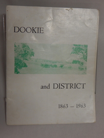
Soft Cover Dookie District History Book - Width 18.5cm x Height 24cm Consist of 33 pages (not numbered), The General Committee Organising the Dookie Back To, Dookie and District 1863 - 1963, Easter 1963 "WATERWHEEL PRESS,"
... on the right. Back Cover - An aerial view of Dookie as it is today... on the right. Back Cover - An aerial view of Dookie as it is today ...Soft Cover Historical Book - White Background with 2 green and white soft aerial photographs of prominent landmarks at Dookie. Front Cover - Mount Major on the left and Saddleback on the right. Back Cover - An aerial view of Dookie as it is today, showing the Grain Elevators Board wheat silos under construction (lower right foreground). -
 National Vietnam Veterans Museum (NVVM)
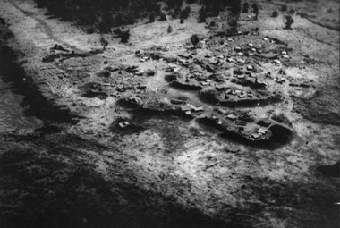
Photograph, Gibbons, Denis, Nui Thai Van Hills FSB
... A black and white photograph of an oblique aerial view... A black and white photograph of an oblique aerial view ...Denis Gibbons (1937 – 2011) Trained with the Australian Army, before travelling to Vietnam in January 1966, Denis stayed with the 1st Australian Task Force in Nui Dat working as a photographer. For almost five years Gibbons toured with nine Australian infantry battalions, posting compelling war images from within many combat zones before being flown out in late November 1970 after sustaining injuries. The images held within the National Vietnam Veterans Museum make up the Gibbons Collection. A black and white photograph of an oblique aerial view of an Australian Fire Support Base at the base of the Nui Thai Van Hills. The FSB provided a battalions direct artillery and mortar support, when on operation away from 1st Australian Task Force Base at Nui Dat, Phuoc Tuy Province. (circa May 1969)photograph, fire support base, 1st atf base, nui thai van hills, gibbons collection catalogue, artillery, mortar, nui dat, phuoc tuy province, denis gibbons -
 Glenelg Shire Council Cultural Collection
Banner - Banner - The Heart of our Region, Nov-10
... images), aerial view of harbour, K.S. Anderson, Lee breakwater... printed in colour both sides (same images), aerial view of harbour ... -
Glenelg Shire Council Cultural Collection
Banner - Banner - Tomorrow's Possibilities, Nov-10
... (same images); aerial view, showing Port and related industries..., printed in colour both sides (same images); aerial view, showing ... -
 Bendigo Historical Society Inc.
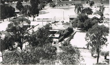
Photograph - LA TROBE UNIVERSITY BENDIGO COLLECTION BENDIGO: TEACHERS' COLLEGE BUILDINGS
... A black and white photograph of an aerial view from... and white photograph of an aerial view from the Lookout Tower ...A black and white photograph of an aerial view from the Lookout Tower in Rosalind Park of Bendigo Teachers' College as it was in the 1950's. In the foreground are aluminium prefabs and the old police stables. In the background is the old gaol and over to the left are the tennis courts which appear to have the sprinklers on. Although it is out of view Camp Hill Primary School is on the right of the buildings. 1950's.bendigo, education, bendigo teachers' college, la trobe university bendigo collection, collection, education, tertiary education, bendigo, bendigo teachers' college, place, buildings, bendigo gaol, tennis courts, gaol, photo, photograph, photographs, photography -
 Whitehorse Historical Society Inc.
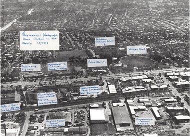
Photograph, Aerial View of various sites in Nunawading, C.1970's
... Aerial View of various sites in Nunawading....2 Black and white copies of Aerial View of various sites... Black and white copies of Aerial View of various sites ...2 Black and white copies of Aerial View of various sites in Nunawading. - Mitcham Technical School, Walker Park , Nunawading Police Station, Bunnings Warehouse, Mobile Industrial Equipment Ltd, Municipal Chambers, Nunawading Library, Turner Industries, Harvey Norman, Feiglins Timber Yard, Holeproof ,Agfa, York Industries and|City of Nunawading. Council Depot.mitcham technical school, walker park, nunawading police station, bunnings warehouse nunawading, mobile industrial equipment ltd., city of nunawading. council chambers, nunawading library, turner industries, harvey norman, feiglins timber yard, holeproof, agfa, york industries, city of nunawading. council depot -
 Otway Districts Historical Society
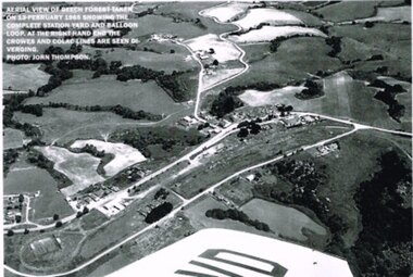
Photograph, R. Preston, Aerial view: Beech Forest, 1965, 13 February 1965
... Aerial view: Beech Forest, 1965....B/W. Aerial view of Beech Forest showing the complete...; B/W. Aerial view of Beech Forest showing the complete ...B/W. Aerial view of Beech Forest showing the complete station yard including the balloon loop (incorporating the two tennis courts), two ex-departmental residences, the station building and where the Colac and Crowes lines diverged. As well Beech Forest Hall, council offices and Shire Secretary's house, Denherts Track, and Main Road are shown.beech forest; railways; township; aerial; -
 Melbourne Tram Museum
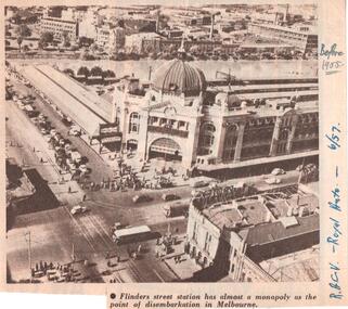
Document - Illustration/s, Royal Automobile club of Victoria (RACv), Jun. 1957
... of an aerial view of Flinders St Station and buildings on the south... the RACV Royal Auto magazine of June 1957 of an aerial view ...Illustration from the RACV Royal Auto magazine of June 1957 of an aerial view of Flinders St Station and buildings on the south side of the Yarra River, showing motor cars, trams and one bus. Also possibly shows the curve from Swanston St into Flinders St. Caption: "Flinders street station has almost a monopoly as the point of disembarkation in Melbourne"In ink on the side" "RACV - Royal Auto - 6/57 Before 1955"trams, tramways, flinders st station, swanston st -
Melbourne Tram Museum
Pamphlet, Minister for Public Transport, "Melbourne's new G class tram", 8/11/2024
... on the design and construction, including an aerial view of the new... on the design and construction, including an aerial view of the new ...Pamphlet titled "Melbourne's new G class tram" - an update on the design and construction, including an aerial view of the new Maidstone depot following a Ministerial visit to the Alstom plant on 8/11/2024 - "Minister for Public and Active Transport Gabrielle Williams today visited Alstom’s factory in Dandenong to announce the start of major works on the Next Generation Trams Project." See htd7796i2 for the Press Release.Yields information about the new G class trams and the new Maidstone depot.Pamphlet - 4 sheets when printedtramcars, new trams, g class, alstom, press release -
Port Melbourne Historical & Preservation Society
Photograph - Aerial view of J Kitchen & Sons site, Port Melbourne, 21 Mar 1939
... Aerial view of J Kitchen & Sons site, Port Melbourne... on buildings) "Aerial view looking East. This view shows the two main...) "Aerial view looking East. This view shows the two main blocks ...Large black and white aerial photo in narrow gold-coloured metal frame of J Kitchen & Sons Pty Ltd factory with Woodruff St in foreground (Electric candles, pure Velvet Soap,and full company name on buildings) "Aerial view looking East. This view shows the two main blocks . 21/3/39" - printed below photo (copy of original)industry - manufacturing, built environment - industrial, j kitchen & sons pty ltd, pental products pty ltd, symex holdings ltd -
 Phillip Island and District Historical Society Inc.
Photograph, Bryant West
... aerial view of cowes...Aerial photograph - panoramic view of Cowes looking north... jetty cowes beaches aerial view of cowes aerial view of cowes ...One of a collection of over 400 photographs in an album commenced in 1960 and presented to the Phillip Island & Westernport Historical Society by the Shire of Phillip Island.Aerial photograph - panoramic view of Cowes looking north-east with Jetty and Foreshore in backgroundlocal history, photography, photographs, cowes foreshore, jetty, cowes, beaches, aerial view of cowes, aerial view of cowes phillip island, john jenner, bryant west -
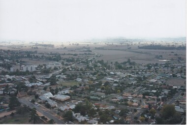
 Lakes Entrance Historical Society
Photograph - Lakes Entrance, 1985c
... Colour photograph showing aerial view of township... Topography Township Colour photograph showing aerial view of township ...Photo was cut from Tourist brochureColour photograph showing aerial view of township and the Ninety Mile Beach. Pecks factory on Bullock Island, Old North Arm bridge, bitumen for carpark for future. Fishermen's Club near North Arm Bridge. Photo shows East end of Rigby Island and Snake Island. Glimpse of Red Bluff, Lake Bunga and Lake Tyers in far east. Lakes Entrance Victoriabridges, coast, waterways, topography, township -
 The Beechworth Burke Museum
Photograph, Unknown
... Aerial view of Lake Sambell, Beechworth with town views...-country Aerial view of Lake Sambell, Beechworth with town views ...Aerial view of Lake Sambell, Beechworth with town views. Lake Sambell is a beautiful Victorian recreation lake and urban park with a unique history. It was created in the mid-1800s by the Rocky Mountain Mining company during the gold rush era and used as a mining site until the early 1900s, which brought Europeans into the area. It was turned into a reserve for residents in 1920 and is considered an icon of Beechworth as it represents the development of the community, human endeavour, and the spirit of the landscape.This photograph represents Lake Sambell with town views.Black and white reproduced rectangular photograph print on paper.Reverse: Stampbeechworth lake, lake sambell, aerial photo, construction, australian landscape, #beechworth, victoria -
 Melbourne Legacy
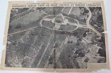
Newspaper - Article, Impressive aerial view of huge crowd at Shrine ceremony, 1934
... Impressive aerial view of huge crowd at Shrine ceremony.... This aerial view of the vast crows was taken as the Duke and his... of dedication performed by the Duke of Gloucester. This aerial view ...A newspaper cutting from 1934 showing the crowd at the opening ceremony of the Shrine of Remembrance. The Shrine was officially opened by the Duke of Gloucester. The caption says 'Marshalled at the Shrine in hundreds of thousands, troops of all arms and services returned soldiers of Australian, British and Dominion units, and a countless mass of citizens, yesterday witnessed the ceremony of dedication performed by the Duke of Gloucester. This aerial view of the vast crows was taken as the Duke and his escort arrived at the southern steps.Early legatees fought hard to have the Shrine of Remembrance accepted as the preferred form of commemoration of the first World War. Early legatees would have been at this ceremony and kept this clipping as a memento.Double page spread in The Sun News-pictorial newspaper on 12 November 1934 after the opening of the Shrine.shrine of remembrance, wreath laying ceremony -
Clunes Museum
Map - DOCUMENTS/MAP, 3 1887. .4 1891
... .1 AERIAL VIEW OF CLUNES AND DISTRICT. COLOUR PHOTOGRAPH.... P. 12. .1 AERIAL VIEW OF CLUNES AND DISTRICT. COLOUR ...MINING, CLUNES GOLD MINES, MAPS, SECTIONS.1 AERIAL VIEW OF CLUNES AND DISTRICT. COLOUR PHOTOGRAPH LAMINATED. .2 MAP OF MINING AREAS SHOWING EXCISED AREA. No. 9104. MINING DISTRICT OF BALLARAT. PARISH OF CLUNES. COUNTY OF TALBOT. SCALE 4 CHAINS TO AN INCH. .3 MAP OF GOLD MINING LEASE BLOCKS AT CLUNES .4 DRAWINGS OF SECTIONS, CLUNES GOLD MINES. SCALE 400 FEET TO AN NCH. ALL MOUNTED WITH PLASTIC HANGING STRIPS..1 ON BACK. CLUNES 1:25000 .2 ASSORTED HANDWITTEN NOTATIONS. .3 ASSORTED HANDWITTEN NOTATIONS. REPLACE IN DEPT. OF MINING REGISTRARS QUARTER ENDED 30TH JUNE 1887. P. 12.clunes, gold mining, leases, aerial photograph, mine sections -
 Bendigo Historical Society Inc.
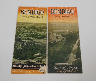
Pamphlet - Two small pamphlets. One titled Bendigo for holidays and health, the other Bendigo for industry
... capital of Victoria. An aerial view of the City and the words... capital of Victoria. An aerial view of the City and the words ...Advertising material promoting the City of BendigoOne pamphlet as at the top Bendigo for industry, Bendigo the northern capital of Victoria, with a drawing of a rising sun. Under a black and white aerial photo of Pall Mall with the soldier's memorial in the foreground and the words: City of trees and sunshine, distributing centre to the golden north at the bottom. The other Bendigo for holidays and health, Bendigo the northern capital of Victoria. An aerial view of the City and the words The city of sunshine and trees, the gateway of the north.advertising, bendigo -
City of Kingston
Photograph - Black and white, 5 January 1984
... aerial view includes Centre Dandenong Road and Cheltenham East... of Kingston. The area depicted in the 1984 aerial view includes Centre ...Cheltenham and Heatherton are suburbs in the City of Kingston that were originally established as a rural market gardening community. The market gardens, farms and paddocks have gradually been sub-divided into housing and industrial estates and associated infrastructure such as schools and shopping facilities. This aerial image covers a diverse section of the City of Kingston, taking in the suburbs of Cheltenham, Heatherton, Mentone and Parkdale. By 1984, the market gardens of the district have been replaced by housing and factories. The Nylex factory is visible and now closed. Mentone Bowl on the corner of Warrigal Road and Nepean Highway has now been replaced by high rise apartments, another feature of the changing landscape in the City of Kingston. The vacant land now occupied by the Moorabbin Airport Direct factory Outlet (DFO) is also depicted.Aerial photograph of Cheltenham, Heatherton, Mentone and Parkdale within the City of Kingston. The area depicted in the 1984 aerial view includes Centre Dandenong Road and Cheltenham East Primary School (top left), Kingston Heath Reserve (top right), intersection of Lower Dandenong Road, Warrigal Road, Balcombe Road and Nepean Highway (bottom left), Balmoral Drive/McSwain Street Parkdale (bottom right).White text: 3831-179 Lens information [indecipherable] RINGWOOD M/S 7922-3 RUN 16 [Clockface image] 5,300' ASL VIC DLS© 5-1-84cheltenham, heatherton, mentone, parkdale, market gardens, urbanisation -
Port Melbourne Historical & Preservation Society
Postcard, South Melbourne Gasworks, c. 1928
... Melbourne Gasworks aerial photographic view, '1928'... Gasworks aerial photographic view, '1928' South Melbourne Gasworks ...One from a set of six postcards related to the Gasworks and produced from early images by the Cty of Port Phillip: South Melbourne Gasworks aerial photographic view, '1928'Cards have three logos: Gasworks Arts, City of Port Phillip, Gas and Fuel Corporationindustry, utilities - gas, built environment - industrial, sandridge lagoon, gasworks, south melbourne gasworks -
 The Beechworth Burke Museum
Photograph, 1960
... Taken in 1960, depicted is an aerial view of Lake Sambell...-country Taken in 1960, depicted is an aerial view of Lake Sambell ...Taken in 1960, depicted is an aerial view of Lake Sambell and the surrounding township. Lake Sambell is a beautiful Victorian recreation lake and urban park with a unique history. It was created in the mid-1800s by the Rocky Mountain Mining company during the gold rush era and used as a mining site until the early 1900s, which brought Europeans into the area. It was turned into a reserve for residents in 1920 and is considered an icon of Beechworth as it represents the development of the community, human endeavour, and the spirit of the landscape.This photograph represents what Lake Sambell looked like in 1960.Black and white reproduced rectangular photograph print on paper.lake sambell, #beechworth, beechworth 1960s, lake, victoria, australian landscape, mining, rocky mountain mining company -
Federation University Historical Collection
Photograph - Photograph - Black and White, N.L. Harvey & Sons Photographers, Ballarat School of Mines Aerial View
... Ballarat School of Mines Aerial View...Aerial view of the Ballarat School of Mines campus from...' junior technical school Aerial view of the Ballarat School ...The Ballarat School of Mines Campus is a campus of Federation University Australia.Aerial view of the Ballarat School of Mines campus from the Grant Stret/Eyre Street corner. The photograph was taken after the demolition of the gaol and before the E.J. Tippett Library and Hillman Recreation Reserve were built. The Ballarat Girls' Technical School is present in Grant Street, and in sthe Ballarat SChool of Mines Mining Laboratory in Albert Street. The Ballarat Brewery (then Carton and United Breweries) is present in Lydiard Street South.aerial, ballarat school of mines, ballarat gaol, ballarat school of mines tennis court, grant street, ballarat girls' junior technical school -
 Bendigo Historical Society Inc.
Photograph - PETHARD COLLECTION: PROMOTE VICTORIA MISSION
... Victoria mission / photos include aerial view of Boston, Heinz... and white photos of Promote Victoria mission / photos include aerial ...GEORGE PETHARD COLLECTION INCLUDING REFERENCES TO TARAXALE BREWING COMPANTY PTY LTD 6 x black and white photos of Promote Victoria mission / photos include aerial view of Boston, Heinz factory, 1957 Universal Pictures Company including American actress Lana Turner from the film The Lady Takes a Flyer / photos are inside a yellow paper brochure with a Boston seal on the front showing the history of Boston.photograph, person, george a pethard, george pethard / taraxale brewing company pty ltd / heinz factory / universal pictures company including american actress lana turne / -
Port Melbourne Historical & Preservation Society
Photograph - Aerial view of J Kitchen & Sons site, Port Melbourne, C D Pratt Airview, 21 Mar 1939
... Aerial view of J Kitchen & Sons site, Port Melbourne... Kitchen & Sons Pty Ltd. On back "Aerial view looking North East... & La...' Photograph Aerial view of J Kitchen & Sons site, Port ...COPYRIGHT C D PRATT Black and white photograph of J Kitchen & Sons Pty Ltd. On back "Aerial view looking North East, 21st March 1939". Signs on three middle buildings 'J Kitchen & Sons Pty Ltd'; 'Pure Velvet Soap'; 'Electrine Candles'. Sign 'Australian Box Mills' on building to left "E L Pinkus' on building to Nort east and behind it 'Petersen & La...'"This photo is copyright" and information on owner - C D Pratt 86 McCracken St, Essendonindustry - manufacturing, j kitchen & sons pty ltd, australian box mills, e l pinkus, petersen -
 Lakes Entrance Historical Society
Postcard - Backwater, Bulmer H D, 1922c
... Black and white photographic postcard, showing early aerial... photographic postcard, showing early aerial view of township of Lakes ...Black and white photographic postcard, showing early aerial view of township of Lakes Entrance, Cunninghame Arm, North Arm and sand dunes, ocean in lower foreground, Eastern wharf and various boats on lake. Princes Highway went along Esplanade, Myer Street and Roadknight Street, very little vegetation on sand dunes, no foot bridge yet, good view of North Arm, few houses. Lakes Entrance VictoriaLakes Entrance and Backwater from the Air.islands, aerial photograph, waterways, topography, township -
 Lake Bolac & District Historical Society
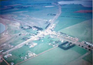
Colour photograph
... Aerial view of Lake Bolac township, looking towards... Highway Lake Bolac grampians Aerial view of Lake Bolac township ...Aerial view of Lake Bolac township, looking towards the north-east, taken circa 1968. The freshwater lake is top-right, the salt-lake is centre-left. The Presbyterian church, bottom right, is surrounded by Cyprus trees on the Woorndoo/Mortlake road. The hotel and general store are opposite each other on the crossroads of the Mortlake/Ararat and Ballarat/Hamilton roads and the sporting complex is behind the store next to the salt lake. The Primary School, No 854, is between the footy oval and the Ararat Road, centre left.lake bolac, freshwater lake, salt lake, presbyterian church, hotel, general store, sporting complex, primary school, no 854. -
 Rutherglen Historical Society
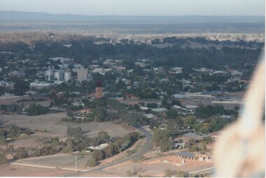
Photograph - Aerial Images, c2000
... Colour aerial photograph of Rutherglen, viewed from... on back of photo: "Water tower (mid) Silos left" Colour aerial ...Colour aerial photograph of Rutherglen, viewed from the North East.Written on back of photo: "Water tower (mid) Silos left"rutherglen, rutherglen winebottle, water tower -
 Rutherglen Historical Society
Photograph - Aerial Images, c2000
... Colour aerial photograph of Rutherglen, viewed from... School just above | & Glenview, Silos mid left" Colour aerial ...Colour aerial photograph of Rutherglen, viewed from the South West.Written on back of photo: "St Stevens lower left corner, State School just above | & Glenview, Silos mid left"rutherglen, st stephens church, saint stephens church, rutherglen winebottle, glenview nursing home, rutherglen state school -
 Orbost & District Historical Society
black and white photograph, February 1971
... This photograph is an aerial view of the township of Orbost... gippsland This photograph is an aerial view of the township ...This photograph is an aerial view of the township of Orbost taken by the Bairnsdale Advertiser newspaper. It was taken from the northern end of the town. The 1971 flood was the the worst flood on record. At Jarrahmond it was at least 11 metres and up to one and a half kilometres wide on the flats causing enormous damage to the flood plain. Records say that "The brown floodwater stain in Bass Strait could be seen from passing airliners." Considerable damage was done to railway infrastructure, roads and farms. More information from the APRIL, 2008 newsletter by John Phillips. (see orbosthistory.com.au)This is a pictorial record of a significant event in the history of Orbost,A black / white aerial photograph of a township with floodwaters in the background.on back - "Note main current through the lagoon 1971."orbost-floods-1971 bairnsdale-advertiser orbost-township -
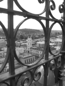 Federation University Historical Collection
Photograph, Lisa Gervasoni, Ballarat Post Office from Town Hall Tower, 2007
... Aerial view of the Ballarat Post Office, corner of Sturt... E.J. Barker Library (top floor) Mount Helen goldfields Aerial ...Aerial view of the Ballarat Post Office, corner of Sturt Street and Lydiard Street North, taken from the tower of the Ballarat Town Hall, corner of Sturt Street and Armstrong Street South. The Post Office was opened in December 1858. Photograph taken through the wrought iron of the tower in 2007. The tower and main entrance to the Post Office face Lydiard Street North. Other buildings from the same era are the former Bank of Australia, opposite corner, and the Mining Exchange. In the distance is Black Hill, an old mining area.Black and white photograph of the Ballarat Post Office on the corner of Sturt Street and Lydiard Street North, taken from the tower of the Ballarat Town Hall corner of Sturt Street and Armstrong Street South. View is taken through the wrought iron of the tower. post office, town hall, tower, wrought iron, sturt street, lydiard street, armstrong street, bank of australia, mining exchange, black hill