Showing 1400 items matching " height"
-
 Geoffrey Kaye Museum of Anaesthetic History
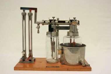
Machine - Boyle's gas anaesthesia apparatus, circa 1937
This is an early example of the Boyle's Anaesthetic Machine which was to become widely used throughout the world. The plaque on the wooden plinth suggests it was a display model from the medical equipment distributor Charles A King of London.The gas anaesthesia apparatus is mounted to a rectangular wooden base. It comprises two long, vertical glass cylinders held in place with metal brackets which are connected to a glass chloroform vaporiser container via metal tubes and associated valves and connections. The bottom of the glass flasks have outlet connections and inscriptions on the glass to measure volume. The chloroform vaporiser and adjacent glass ether vaporiser also have volume measurements etched on the glass, and the latter is the same height as the former but is larger in diameter. Both are connected via metal tubes and include outlet pipes that have associated cork stoppers. The maker's details are provided on a brass plaque attached to thewooden platform.A. Charles King Ltd. London, W1.henry edmund gaskin boyle, vaporiser, rotameter, chloroform, ether, anaesthetic apparatus, charles king ltd, plenum, sectioned, dr geoffrey kaye -
 Bendigo Military Museum
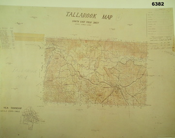
Map - Australian Topographical Survey TALLAROOK SE Sheet, 1 inch:1 Mile, NW portion Plane Table Field sheet 1923, Australian Survey Corps, 1923
This is a coloured reproduction print of an original Plane Table compilation map sheet of Tallarook area 1inch to 1 Mile scale compiled by Sgt Jack Cullen Australian Survey Corps 12 November 1923 and signed by Capt J Lynch. Capt Lynch and Sgt Cullen were both foundation members of the Australian Survey Corps. Of particular interest is the fact that this is a heighted compilation with contouring (required for Military use) as many early maps were purely planimetric. The reverse side of this print is a copy of the Nagambie plane table South West field sheet.Reprinted coloured Image of Australian Topographical Survey TALLAROOK SE field Sheet,1 inch:1 Mile, hand drawn contoured Plane Table Field sheet. Signed by Sgt J Cullen Australian Survey Corps November1923. An enlargement of YEA Township 2 Inches to 1 Mile Scale.royal australian survey corps, rasvy, fortuna, army survey regiment, army svy regt, asr -
 Eltham District Historical Society Inc
Photograph - Aerial Photograph, Landata, Eltham, Luck St; Bible St to Beard St, Dec. 1945
Centred on present day Eltham East Primary School, east of Main Rd along Luck St to Beard St Historic Aerial Imagery Source: Landata.vic.gov.au Aerial Photo Details: Project No :5 Project : MELBOURNE AND METROPOLITAN AREA PROJECT Run : 36 Frame : 60548 Date : 12/1945 Film Type : B/W Camera : EAG4 Flying Height : 10200 Scale : 6000 Film Number : 195 GDA2020 : 37°42'46"S, 145°09'18"E MGA2020 : 337371, 5824456 (55) Melways : 22 A4 (ed. 42)aerial photo, eltham, arthur street, beard street, bible street, eltham east primary school, frank street, henry street, luck street, stanley avenue, wycliffe crescent, neil webster collection -
 Eltham District Historical Society Inc
Photograph - Aerial Photograph, Landata, Eltham, Main Rd; Railway Rd to Zig Zag Rd, Dec. 1945
Centred on present day Edendale Farm from Glen Park rd to Zig Zag Rd Historic Aerial Imagery Source: Landata.vic.gov.au Aerial Photo Details: Project No :5 Project : MELBOURNE AND METROPOLITAN AREA PROJECT Run : 37 Frame : 60549 Date : 12/1945 Film Type : B/W Camera : EAG4 Flying Height : 10200 Scale : 6000 Film Number : 196 GDA2020 : 37°42'12"S, 145°09'09"E MGA2020 : 337141, 5825486 (55) Melways : 21 K2 (ed. 42)aerial photo, eltham, edendale farm, eltham - yarra glen road, eltham-hurstbridge railway line, gastons homestead, gastons road, glen park road, main road, park road, railway road, wattletree road, zig zag road, neil webster collection -
 Warrnambool and District Historical Society Inc.
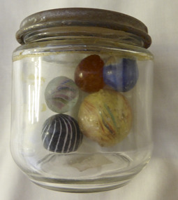
Mixed media - Toy, Marbles, Late 19th century
There is evidence of the game of marbles in the ruins of Pompeii and the tombs of Egyptians as well as early American Indians. The earliest marbles were simply rounded stones which had been polished but this was refined to handmade versions made of clay, stone and glass. It was in the late 19th century that mass production began and it gives testament to the popularity of the game that the Dyke factory of Ohio could produce 1,000,000 marbles a day. It was around 1915 that the mass production of glass marbles began. The game reached the height of popularity in the 1920-1930’s. Many were prized for their designs.The game of marbles was one of the most common games played universally, from childhood hence has a strong link with people of all ages and cultures. Five marbles in glass jar. All are various sizes ranging from large yellow streaked with red and blue, black striped with white, marbled tan, clear with multi coloured streaks and bright blue. Shapes are roughly spherical. Materials range from glass to glazed and stone. Three have pontil marks either on end.The lid of the jar has Nestle vacuumed sealed for extra protection. Use special key to open. Old sticker on base with 173 written in black lead pencil. toys, marbles, children's games, warrnambool, handmade marbles, glass marbles, clay marbles, agate marbles -
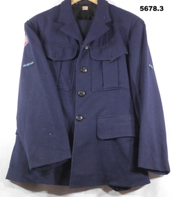 Bendigo Military Museum
Uniform - SERVICE DRESS, WINTER, RAAF, c1942
John William HARKIN. No. 170317, Enlisted 27.06.44, Age 18. Discharged 6.12.48. Rank of LAC in 381 (B)SQD.1. Dress coat - navy blue colour wool fabric, black colour, cotton lining with beige colour cotton lining to sleeves. Buttons - black colour bakelite with metal shank, emblazoned with the King's Crown and a Wedgetailed eagle in flight WW2. On sleeves - Australia shoulder patch with wings and a propeller patch. Right sleeve - gold, blue and red colour "British Commonwealth Forces" patch. Makers label back below collar. 2, Trousers - navy blue colour wool fabric, owners label inside back, 5 button fly. 3. Trousers - navy blue colour wool fabric, makers size label inside back, 4 button fly.1. Maker's label - red embroidery on cotton fabric "M TX/ Size 18". Handwritten black ink "HARKIN'. 2. Owner's label - black ink on cotton "HARKIN/JW/ R.A.A.F." 3. Maker's label - blue ink print on cotton "N384/1942/ SIZE 24". Maker's label on back of trousers - dark blue print on paper - "AIRMEN'S/ TROUSERS'/ 18oz/ Size 24/ Waist 37../ Height 5'9"to 5'10". Black ink stamp "I/ E.C."uniforms, raaf, ww2 -
 Bendigo Military Museum
Map - Australian Topographical Survey NAGAMBIE SW Sheet, 1 inch:1 Mile, NW portion Plane Table Field sheet 1921, Australian Survey Corps, 1921
This is a coloured reproduction print of an original Plane Table compilation map sheet of Nagambie area 1inch to 1 Mile scale compiled by Sgt Jack Cullen Australian Survey Corps 30 September 1921. Jack was one of the foundation members of the Australian Survey Corps. Of particular interest is the fact that this is a heighted compilation with contouring (required for Military use) as many early maps were purely planimetric. A table on the right hand side details the number of days that it took to produce the compilation. The reverse side of this print is a copy of the Tallarook plane table South East field sheet.Reprinted coloured Image of Australian Topographical Survey NAGAMBIE SW Sheet,1 inch:1 Mile, NW portion hand drawn Plane Table Field sheet. Includes an itemized summary of work, signed by Sgt J Cullen Australian Survey Corps September1921.royal australian survey corps, rasvy, fortuna, army survey regiment, army svy regt, asr -
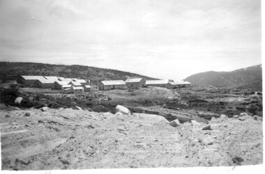 Kiewa Valley Historical Society
11 Black and White photographs of the Rocky Valley area, c1948
In October 1947 construction was commenced on the erection of the workmen's camp at Rocky Valley. Also in 1947 construction of a stream diversion was commenced to allow excavation to commence for the dam wall. In the summer of 1948/49, stripping of the foundation area on both sides of the river was carried out. Weather conditions were not always favourable during the construction, particularly 1955/56 summer, and work would have to cease each year for the winter season due to the severe conditions. The dam is a earth and rock fill structure with a height of about 30.5 metres and crest length 518.16 metres and was completed in March, 1959.These photographs show the type of terrain in the area prior to the construction and filling of Rocky Valley Dam. Also of interest is the type of accommodation provided for those working on the construction and the early cranes available in the 1940/50's. Of historical importance to understand the conditions in the early construction of the Kiewa Hydro Electric SchemeEleven small black and white photographsPhoto No. 1 - on the back, printed in ink"Rocky Valley - New Mess & offices Dec. 1948". In pencil '14 on the back Photo No. 2 - on the back, printed in ink "Rocky Valley Camp. October 1948". Also stamped on the back "998L" Photo No. 3 -on the back, printed in ink "Rocky Valley Hostel October 1948". Also stamped on the back '998L' Photo No. 4 - on the back, printed in ink "Spion Kopje from bedroom window. October 1948". Stamped on the back '998L'. Photo No. 5 - on the back, printed in ink "Rocky Valley Basin Dec. 1948." In pencil on back, 14. Photo No. 6 - on the back, printed in ink "Site of Wall for Rocky Valley Dam Dec. 1948". In pencil on back, 14. Photo No. 7 - On the back, printed in ink "Commencing of Diversion Tunnel Rocky Valley December 1948". In pencil on back, 14. Photo No. 8 - on the back, printed in ink "One of the two electric cranes at Rocky Valley December 1948". In pencil on back, 14. Photo No. 9 - on the back, printed in ink "'Rapier' (H.Y.) electric crane Rocky Valley December 1948". In pencil on back, 14 . Photo No. 10 - on the back, printed in ink " Pretty Valley Pump line construction Mt. Cope in Background Nov 1948. Circular stamp with the words 'print by Wilson White Albury' in the circle. Photo No. 11 - on the back, printed in ink "Stringing cable on Ruined Castle October 1948. Same stamp as No. 10. In pencil '31'. rocky valley; pretty valley; ruined castle; bogong high plains; kiewa hydro electric scheme -
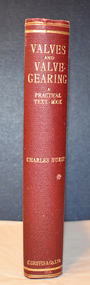 Warrnambool and District Historical Society Inc.
Book, Charles Hurst, Valves and Valve-Gearing, 1907
This is a technical book regarding valves and their maintenance in machinery.This is a book of 258 pages plus 86 pages of advertisements. The cover is dark red with an embossed shield on the front cover and gold printing on the spine. The pages contain a black and white photograph, many illustrations and diagrams and several pages of fold-out sketches. non-fictionThis is a technical book regarding valves and their maintenance in machinery. henry family, warrnambool woollen mill, valves and valve gearing -
 Eltham District Historical Society Inc
Photograph - Aerial Photograph, Landata, Research, Vic, Apr. 1963
Centred on present day Marconi Court, Research bounded by Maroondah Aqueduct to north, Thompson Crescent to south, Joselyn Drive to east and Eltham Research Oval to west. Historic Aerial Imagery Source: Landata.vic.gov.au Aerial Photo Details: Project No :486 Project : MELBOURNE (1963) PROJECT Run : 5 Frame : 62 Date : 04/1963 Film Type : B/W Camera : RC8 Flying Height : 5100 Scale : 9600 Film Number : 1805 GDA2020 : 37°42'24"S, 145°10'43"E MGA2020 : 339434, 5825157 (55) Melways : 22 F3 (ed. 42)aerial photo, neil webster collection, 1963-04, joselyn drive, marconi court, melway 22f3, research (vic.), research oval, thompson crescent -
 Eltham District Historical Society Inc
Photograph - Aerial Photograph, Landata, Research, Vic, Apr. 1972
Centred on present day Maroong Drive, Research bounded by Allendale Road to north, Thompson Crescent to south, Eltham College to east and Parsons Road to west. Historic Aerial Imagery Source: Landata.vic.gov.au Aerial Photo Details: Project No :985 Project : MELBOURNE 1972 Run : 26 Frame : 193 Date : 04/1972 Film Type : B/W Camera : RC10 Flying Height : 5700 Scale : 9600 Film Number : 2636 GDA2020 : 37°42'04"S, 145°10'33"E MGA2020 : 339187, 5825794 (55) Melways : 22 F1 (ed. 42)aerial photo, neil webster collection, 1972-04, allendale road, eltham, eltham barrel, eltham college, maroong drive, melway 22f1, parsons road, research (vic.), thompson crescent -
 Eltham District Historical Society Inc
Photograph - Aerial Photograph, Landata, Eltham, Vic, Apr. 1972
Centred on present day Ryans Road at Sandra Avenue, Eltham bounded by Progress Road to north, Brougham Street to south, Bible Street to east and Outlook Crescent to west. Historic Aerial Imagery Source: Landata.vic.gov.au Aerial Photo Details: Project No :985 Project : MELBOURNE 1972 Run : 27 Frame : 48 Date : 04/1972 Film Type : B/W Camera : RC10 Flying Height : 5700 Scale : 9600 Film Number : 2636 GDA2020 : 37°42'41"S, 145°08'38"E MGA2020 : 336392, 5824574 (55) Melways : 21 H4 (ed. 42)aerial photo, neil webster collection, 1972-04, eltham, bible street, brougham steet, melway 21h4, outlook crescent, progress road, ryans road, sandra avenue, montmorency -
 Eltham District Historical Society Inc
Photograph - Aerial Photograph, Landata, Montmorency, Vic, Apr. 1972
Centred on present day Olympic Avenue at Grand Boulevard, Montmorency bounded by Meruka Drive to north, Main Road to south, Main Road to east and Alban Street to west. Historic Aerial Imagery Source: Landata.vic.gov.au Aerial Photo Details: Project No :985 Project : MELBOURNE 1972 Run : 28 Frame : 206 Date : 04/1972 Film Type : B/W Camera : RC10 Flying Height : 5700 Scale : 9600 Film Number : 2635 GDA2020 : 37°43'21"S, 145°07'46"E MGA2020 : 335154, 5823329 (55) Melways : 21 E7 (ed. 42)aerial photo, neil webster collection, 1972-04, eltham, alban street, grand boulevard, lower plenty, main road, melway 21e7, meruka drive, montmorency, olympic avenue -
 Eltham District Historical Society Inc
Photograph - Aerial Photograph, Landata, Eltham, Vic, Apr. 1972
Centred on present day Mays Road at Stringybark Road, Eltham bounded by Nyora Road to north, Yarra River to south, Reynolds Road to east and Bible Street to west. Historic Aerial Imagery Source: Landata.vic.gov.au Aerial Photo Details: Project No :985 Project : MELBOURNE 1972 Run : 28 Frame : 209 Date : 04/1972 Film Type : B/W Camera : RC10 Flying Height : 5700 Scale : 9600 Film Number : 2635 GDA2020 : 37°43'33"S, 145°09'28"E MGA2020 : 337647, 5823013 (55) Melways : 22 B8 (ed. 42)aerial photo, neil webster collection, 1972-04, eltham, bible street, mays road, melway 22b8, nyora road, reynolds road, stringybark road, yarra river -
 Eltham District Historical Society Inc
Photograph - Aerial Photograph, Landata, Eltham, Main Road; Henry St to Bellevue Rd, Dec. 1945
Eltham, Main Road; Henry St to Bellevue Rd, and east along Luck St to present day Eltham East School Historic Aerial Imagery Source: Landata.vic.gov.au Aerial Photo Details: Project No :5 Project : MELBOURNE AND METROPOLITAN AREA PROJECT Run : 36 Frame : 60549 Date : 12/1945 Film Type : B/W Camera : EAG4 Flying Height : 10200 Scale : 6000 Film Number : 228 GDA2020 : 37°42'45"S, 145°08'59"E MGA2020 : 336903, 5824465 (55) Melways : 21 K4 (ed. 42)aerial photo, arthur street, bellevue road, bible street, diamond street, dudley street, elsa court, eltham, eltham east primary school, gahan house, henry street, livingstone road, luck street, main road, pryor street, neil webster collection -
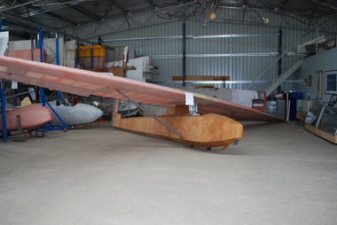 Australian Gliding Museum
Machine - Glider – Sailplane, 1930s
This Dunstable Kestrel glider, which came to be known as the "Red Kestrel" on account of its colour scheme, was built from plans by Percy Pratt between 1936 and 1938. It was first flown in 1938. Thereafter, it was flown regularly by Pratt at Geelong, Victoria. At the national rally organized by the Australian Gliding Association in December 1939 – January 1940 at the Belmont Common, Geelong, Victoria, Pratt, in his Kestrel, recorded an exceptional 13 kilometre cross country flight of one hour 43 minutes reaching a height of approximately 5500 metres [Allan Ash, Gliding in Australia, p 86]. This Dunstable Kestrel glider represents a good example of a 1930s era sailplane. It is one of three of the type that currently exist in Australia. The aircraft is also important for Australian gliding history because it was built, owned and flown by gliding pioneer Percy Pratt.Wooden airframe covered with plywood and fabric. In course of restoration.australian gliding, glider, sailplane, dunstable, kestrel, bill manuel, percy pratt, belmont, geelong -
 Robin Boyd Foundation
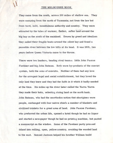
Document - Manuscript, Robin Boyd, The Melbourne Book, 1966
Description of first grid drawn of Melbourne by Robert Hoddle and design impetus; naming of gridiron streets; Charles Troedel prints/The Melbourne Album, F. Cogne drew Melbourne scenes on lithographic stones; Harold Freedman drew same scenes of Melbourne 1964/65; comparative discussion of Melbourne then and now; between 1865-1965 substantial buildings erected and demolished; cable tram; strength and delicacy of Melbourne style; first tree planting; first electric tram 1927; lifting of building height limits 1956; list of representative buildings; Melbourne unlike other capitals as it was not conceived as a capital city.Published as a chapter titled 'The Town at Port Phillip' in 'The Book of Melbourne and Canberra', The Griffin Press, Adelaide 1966Typewritten (c copy), quarto, 14 pagesjohn batman, john fawkner, robert russell, robert hoddle, charles troedel prints/the melbourne album, f. cogne; cable trams; building height limits; tree planting; electric tram 1927; representative buildings, robin boyd, manuscript -
 Bendigo Historical Society Inc.
Photograph - Postcards of Bendigo, Valentine and Sons Publishing Co, c1910
Valentine & Sons of Dundee were Scotland’s most successful commercial photographers. In the early 1900s, at the height of the postcard craze, they published large numbers of postcards in the U.K., Canada, U.S., Australia and South Africa. Even though enthusiasm for postcards eventually waned, Valentine & Sons continued to produce cards into the 1960s and 1970s. Numerical ranges belonged to Valentine & Sons’ branches in other countries, as follows: USA – 200,000s; Australia – 300,000s; and South Africa – 500,000s. New Zealand cards were produced but these seem generally to have been numbered in the U.K. series, which bore numbers less than 100,000. Thirty-eight photos of postcards of Bendigo, city centre, published by Valentine and Sons Publishing Co.history, bendigo, ted hocking collection, valentine postcards -
 Ballarat Tramway Museum
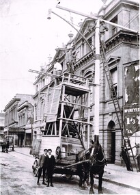
Photograph - Positioning street lights - Lydiard St North, Ballarat late 1890s
Photo of the installation of an electric arc type street lamp in Lydiard St North, near the Provincial Hotel Ballarat. The tower wagon is drawn by a single horse. Two boys standing alongside while two men are on the top of the wagon, a man on the top of the ladder is positioning a lifting beam while two men on the ground hold the rope for this beam. On the side of the wagon is possibly an extension that could be lifted onto the top of the tower itself to give a greater working height. The buildings between Mair St and the railway station on the west side of Lydiard St North remain in position. Yields information about the methodology of the late 1890's to install street lighting in BallaratDigital print of a Positioning street lights Lydiard St North Ballarat late 1890sarc lamps, ballarat, lydiard st north, electric lighting, tower wagons, horses, workmen, street lights -
 Wodonga & District Historical Society Inc
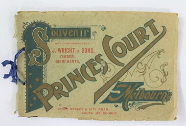
Booklet - Souvenir Booklet for Princes Court Amusement Park, Melbourne c. 1904-1905
Princes Court was an amusement park in Melbourne, located on St Kilda Road. Established in 1904, it closed its doors in 1909 after poor ticket sales due to Melbourne's temperamental weather. The park featured a toboggan ride and water chute ride where patrons inside open carriages were plunged down sloping structures from a height at great speeds. The park's other facilities and activities included a rifle range, a tug of war game, a Japanese tea house, a wine bar, a variety show, an open air cinema, and roller skating and bicycle races.This item contributes to our understanding of social life and recreation in early twentieth century Victoria. A souvenir booklet for Princes Court, an amusement park in Melbourne, printed for the years 1904-5. The booklet features photographs of the park's attractions, and advertisements for local businesses in Melbourne. wodonga, melbourne, princes park, amusement park, rides, fair, fairground, japanese tea house, st kilda -
 Eltham District Historical Society Inc
Photograph - Aerial Photograph, Landata, Montmorency / Lower Plenty, Jan. 1973
Centred on 385 Main Road, Lower Plenty bounded by Grand Boulevard, Montmorency to north, Old Eltham Road to south, Bolton Street to east and Panorama Avenue to west. Historic Aerial Imagery Source: Landata.vic.gov.au Aerial Photo Details: Project No :1043 Project : MONTMORENCY Run : 2 Frame : 124 Date : 01/1973 Film Type : B/W Camera : RC8 Flying Height : 2200 Scale : 4000 Film Number : 2722 GDA2020 : 37°43'48"S, 145°07'49"E MGA2020 : 335243, 5822507 (55) Melways : 21 E9 (ed. 42)aerial photo, lower plenty, main road, montmorency, phoebe mason collection, bolton steet, grand boulevard, old eltham road, panorama avenue -
 Wangaratta Historical Society
Wooden Fruit Bowl, Red Gum Bowl
This wood is made from Red River Gum tree wood, these trees live for between 500 to 1,000 years of age. The wood in this bowl has been carbon dated in the USA to be 4,500 years old.This bowl is significant because of the age of the wood it is made from. 000016 Wooden Fruit Bowl The timber this fruit bowl was made from was a red gum tree taken from the Ovens river at Tarrawingee (12 km from Wangaratta)where it had been submerged for years. It was made on a lathe by Ken Hill. The bowl warped and cracked shortly after being turned. A piece of the wood was taken to the USA by a visitor where it was carbon dated to be 4500 years old Measurements: Diameter: 22cm Height: 6cm Colour: Dark red brown Photographed beside a piece of natural red gum Tarrawingee is 12 Km North East of Wangaratta on the Great Alpine Road Significance: 4500 year old red gum wood is rare in this area. red river gum wooden bowl wangaratta historical society -
 Eltham District Historical Society Inc
Photograph - Aerial Photograph, Landata, Eltham / Research, Vic, Jan. 1951
Centred on Brinkkotter Road opposite Yarramie Reserve, Eltham bounded by Maroondah Aqueduct to north, Nyora Road to south, Eltham College to east and Leane Drive to west. Historic Aerial Imagery Source: Landata.vic.gov.au Aerial Photo Details: Project No :65 Project : MELBOURNE AND METROPOLITAN PROJECT NO. 2 Run : 7 Frame : 8 Date : 01/1951 Film Type : B/W Camera : EAG9 Flying Height : 12200 Scale : 12000 Film Number : 1419 GDA2020 : 37°42'32"S, 145°10'41"E MGA2020 : 339408, 5824924 (55) Melways : 22 F3 (ed. 42)Historical aerial photos and photo maps provide viusal evidence of the chronology of changes to the built landscape of the district and assist in dating other imagesaerial photo, 1951-01, eltham, neil webster collection, brinkkotter road, eltham college, leane drive, maroondah aqueduct, melways 22f3, nyora road, yarramie reserve -
 Eltham District Historical Society Inc
Photograph - Aerial Photograph, Landata, Eltham, Vic, Jan. 1951
Centred on Beard Street between Main Road and Frank Street, Eltham bounded by Maroondah Aqueduct to north, Arthur Street to south, Maroong Drive to east and Catholic Ladies College to west. Historic Aerial Imagery Source: Landata.vic.gov.au Aerial Photo Details: Project No :65 Project : MELBOURNE AND METROPOLITAN PROJECT NO. 2 Run : 7 Frame : 9 Date : 01/1951 Film Type : B/W Camera : EAG9 Flying Height : 12200 Scale : 12000 Film Number : 1419 GDA2020 : 37°42'23"S, 145°09'39"E MGA2020 : 337874, 5825170 (55) Melways : 22 B3 (ed. 42)Historical aerial photos and photo maps provide viusal evidence of the chronology of changes to the built landscape of the district and assist in dating other imagesaerial photo, 1951-01, eltham, neil webster collection, arthur street, beard street, catholic ladies college, frank street, main road, maroondah aqueduct, maroong drive, melway 22b3, research (vic.) -
 Eltham District Historical Society Inc
Photograph - Aerial Photograph, Landata, Eltham North, Feb. 1956
Centred on present day 54 Kelway Crescent, Eltham North bounded by Glen Gully Road to north, Meruka Drive to south, Eltham College to east and Leach Street to west. Historic Aerial Imagery Source: Landata.vic.gov.au Aerial Photo Details: Project No :250 Project : MELBOURNE OUTER SUBURBS PROJECT Run : 17 Frame : 113 Date : 02/1956 Film Type : B/W Camera : EAG9 Flying Height : 10000 Scale : 12000 Film Number : 1176 GDA2020 : 37°42'16"S, 145°08'08"E MGA2020 : 335650, 5825336 (55) Melways : 21 G2 (ed. 42)aerial photo, 1956-02, eltham, eltham north, glen gully road, leach street, main road, melway 21g2, meruka drive, montmorency, neil webster collection -
 Eltham District Historical Society Inc
Photograph - Aerial Photograph, Landata, Montmorency, Feb. 1956
Centred on present day Tahlee Place Reserve and Sherbourne Preschool, Montmorency bounded by Progress Road to north, Withers Way to south, Main Road to east and Leach Street to west. Historic Aerial Imagery Source: Landata.vic.gov.au Aerial Photo Details: Project No :250 Project : MELBOURNE OUTER SUBURBS PROJECT Run : 17 Frame : 114 Date : 02/1956 Film Type : B/W Camera : EAG9 Flying Height : 10000 Scale : 12000 Film Number : 1176 GDA2020 : 37°42'50"S, 145°08'02"E MGA2020 : 335512, 5824286 (55) Melways : 21 F5 (ed. 42)aerial photo, 1956-02, neil webster collection, central park, eltham, leach street, main road, melway 21f5, montmorency, progress road, withers way, sherbourne preschool, tahlee place reserve -
 Eltham District Historical Society Inc
Photograph - Aerial Photograph, Landata, Lower Plenty, Feb. 1956
Centred on present day 217 Old Eltham Road, Lower Plenty bounded by Pitt Street to north, Yarra River to south, Main Road to east and Bonds Road to west. Historic Aerial Imagery Source: Landata.vic.gov.au Aerial Photo Details: Project No :250 Project : MELBOURNE OUTER SUBURBS PROJECT Run : 17 Frame : 116 Date : 02/1956 Film Type : B/W Camera : EAG9 Flying Height : 10000 Scale : 12000 Film Number : 1176 GDA2020 : 37°43'58"S, 145°07'49"E MGA2020 : 335237, 5822186 (55) Melways : 21 E10 (ed. 42)aerial photo, 1956-02, neil webster collection, eltham, main road, bonds road, elham, lower plenty, melway 21e10, pitt street, yarra river -
 Eltham District Historical Society Inc
Photograph - Aerial Photograph, Landata, Eltham, Feb. 1956
Centred on present day Shalbury Avenue, Eltham bounded by Leane Drive and Parsons Road to north, Nyora Road to south, Reynolds Road to east and the Diamond Creek to west Historic Aerial Imagery Source: Landata.vic.gov.au Aerial Photo Details: Project No :250 Project : MELBOURNE OUTER SUBURBS PROJECT Run : 18 Frame : 95 Date : 02/1956 Film Type : B/W Camera : EAG9 Flying Height : 10000 Scale : 12000 Film Number : 1176 GDA2020 : 37°41'57"S, 145°09'51"E MGA2020 : 338145, 5825965 (55) Melways : 22 C1 (ed. 42)aerial photo, 1956-02, neil webster collection, eltham, diamond creek (creek), melway 22c1, nyora road, parsons road, reynolds road, shalbury avenue -
 Eltham District Historical Society Inc
Photograph - Aerial Photograph, Landata, Research, Vic, Feb. 1956
Centred on present day Thompson Crescent, Research bounded by Maroondah Aqueduct to north, Thompson Crescent and Nyora Road to south, Bells Hill Road to east and Eucalyptus Road to west Historic Aerial Imagery Source: Landata.vic.gov.au Aerial Photo Details: Project No :250 Project : MELBOURNE OUTER SUBURBS PROJECT Run : 19 Frame : 6 Date : 02/1956 Film Type : B/W Camera : EAG9 Flying Height : 10000 Scale : 12000 Film Number : 1176 GDA2020 : 37°42'38"S, 145°11'02"E MGA2020 : 339927, 5824736 (55) Melways : 22 H4 (ed. 42)aerial photo, 1956-02, neil webster collection, bells hill road, eltham, eucalyptus road, maroondah aqueduct, melway 22h4, nyora road, research (vic.), thompson crescent -
 Eltham District Historical Society Inc
Photograph - Aerial Photograph, Landata, Research, Vic, Apr. 1963
Centred on present day Thompson Crescent and Nicholson Close, Research bounded by Maroondah Aqueduct to north, Nyora Road to south, Eltham College to east and Eltham Gateway Hotel to west. Historic Aerial Imagery Source: Landata.vic.gov.au Aerial Photo Details: Project No :486 Project : MELBOURNE (1963) PROJECT Run : 5 Frame : 61 Date : 04/1963 Film Type : B/W Camera : RC8 Flying Height : 5100 Scale : 9600 Film Number : 1805 GDA2020 : 37°42'24"S, 145°10'06"E MGA2020 : 338528, 5825143 (55) Melways : 22 D3 (ed. 42)aerial photo, neil webster collection, eltham, 1963-04, eltham college, eltham gateway hotel and conference centre, maroondah aqueduct, melway 22d3, nicholson close, nyora road, research (vic.), thompson crescent