Showing 720 items matching " stables"
-
 Glen Eira Historical Society
Photograph - Lirrewa
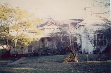
... Stables ...Two items all related to Lirrewa 1/Three copies of auctioneer’s brochure for sale of Lirrewa showing a sketch and floor plan. Auctioneer GA Thomson & Co 2/Colour photograph of Lirrewa, c 1983, undated and unsignedlirrewa, lirrewa grove, stables, brooks gl, thomson ga & co, estate agents, murrumbeena road, murrumbeena, lofts, slate tiles, house names, flats -
 Federation University Historical Collection
Booklet, Michael Taffe, Beaufort House Ballarat Conservation Plan, 2004
... stables ...Michael Taffe undertook this Conservation Pan while completing an Bachelor of Arts (Honours) at the University of Melbourne in 2004.Forty five page conservation management plan for Beaufort House. Includes: * Dowling Forest Paris Plan * Plan of Drainagebeaufort house, student residences, student accomodation, certificate of title, dowling forest, henry cuthbert, archibald mckay, max mckay, beaufort street, cardigan street, stables, charles davernport cuthbert -
Canterbury History Group
Document - Canterbury Mansions and Stables, 13/03/1991 12:00:00 AM
... Stables ...Photocopy of a document relating to the Draft Statement of Significance for Canterbury Mansions. Contains a short history of Canterbury, the role the hotel has played in that history, and descriptions of the interior and exterior. Includes many photographs and 2 mapscanterbury, canterbury mansions, canterbury club hotel, canterbury road, city of boroondara, historic buildings register, jacob lewis vines, malone family, temperance movement, wattle valley road, stables, outbuildings -
Canterbury History Group
Book, Allom Lovell Sanderson Pty Ltd, Conservation Management Plan, Frognall Canterbury Vic. Vol 1
... Stables ...Contains the conservation analysis and broad conservation management plan as well as a description of the physical condition of the buildings for RAAF Frognall.canterbury, mont abert road, frognall, verulan, mountfield, gall> james, towers, stables, staircases, royal australian air force, city of camberwell, elgar's special survey -
 Mt Dandenong & District Historical Society Inc.
Photograph, View From George Barber's Home On Olinda Creek Towards The Gap. c1905, 1905
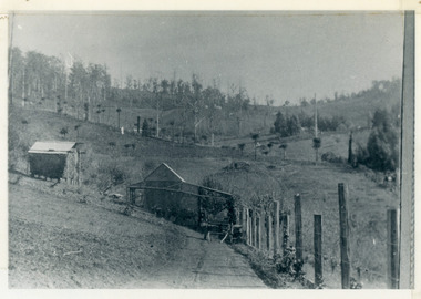
Black and white photograph showing view towards The Gap (Jeeves Saddle), (Five Ways) taken c1905. Detailed inscription on back handwritten by John Lundy-Clarke in 1973.1905 (c ) view from Barber’s home on Olinda Creek, towards the Gap, then known as Jeeves Saddle. Barber’s stable in foreground. “Shiloah” Complex centre right. Tait’s house in gully just left of centre. Logan’s house can just be seen under magnifier at top of same gully near line of Barber’s Road. “Kalorama” just below lowest portion of Gap skyline with Barnes (Paynters) house “Iona” to its left. Photo copied 1973. JLC. george barber, shiloah, kalorama, iona, olinda creek, the gap, jeeves saddle, tait, paynter, barber -
 Warrnambool and District Historical Society Inc.
Plate, Rolfe dinner plates x 4, 1864
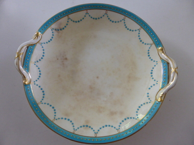
These dishes were part of a crockery set used in the George Rolfe household at Lyndoch, Warrnambool. George Rolfe (1836-1919) was a Melbourne tea merchant who acquired land at the mouth of the Hopkins River in Warrnambool from the 1880s on as a holiday home. He developed the property over the years, adding a windmill and reservoir, bone and chaff sheds, a stable, jetty and boathouse and an extensive garden. In 1891 he married Mrs Annie Lake and it was his stepdaughter, Florence Lake who built the house, Lyndoch in the 1920s. This building today forms part of an Aged Care Facility. This item is part of the larger Rolfe dinner set as described on Victorian Collections at VC001421 and VC001422These dishes are of importance as they belonged to the George Rolfe family of Lyndoch, Warrnambool. They demonstrate the quality of the household goods used by more affluent families in the second half of the 19th century. These are four china serving dishes or plates which are part of a set of crockery used in the Rolfe Lyndoch household in Warrnambool. The dishes have a circular base with a circular dish resting on the base. The dishes have or had two handles with these handles and the edges of the dishes being gold trimmed. Around the rim of the dishes is a pattern of loops and dots etc of teal and gold. One dish (.1) has no handles, one dish (.4) has one handle only and two dishes are cracked (.3 & .4) . Two dishes are stained, one severely (.2 & .4) ‘Minton’ george rolfe, florence lake -
 Warrnambool and District Historical Society Inc.
Plates, Rolfe Saucers x 6, 1864
These saucers are part of a crockery set that belonged to George Rolfe and his family. George Rolfe (1836-1919) was a tea merchant in Melbourne who bought land at the mouth of the Hopkins River in Warrnambool in the 1880s. He had adjoining land and the properties of ‘Shipley’ and ‘Fairy Hill’ and developed ‘Lyndoch’, adding stables, jetty, boat house, windmill and reservoir, chaff and bone sheds and an extensive garden. In 1891 he married Annie Lake and it was his stepdaughter, Florence Lake who built the ‘Lyndoch’ house still standing today. ‘Lyndoch’ today is now the site of an Aged Care Facility. This item is part of the Rolfe Dinnerset as described on Victorian Collections at VC001420 and VC001422.These saucers, part of a crockery set, are kept because they belonged to George Rolfe, a prominent property owner and farmer in Warrnambool in the late 19th century and early 20th century. The items, dating from 1864, have social significance showing the type of crockery used by a more affluent family in the 19th century. These are six circular china saucers with a gold rim and ornamentation in a scallop design in gold and teal around the rim and the outer edges. The base of the saucers has a gold rim. One of the saucers has a chip on the edge and four show significant wearing of the inner gold circle. Some of the outside gold edging also shows wear. The maker’s marks and name are indented on the bottom of the saucers ‘Minton’ lyndoch, warrnambool, rolfe and co., george rolfe, history of warrnambool, florence lake -
 Warrnambool and District Historical Society Inc.
China, Cups x 4, 1864
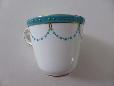
These dishes were part of a crockery set used in the George Rolfe household at Lyndoch, Warrnambool. George Rolfe (1836-1919) was a Melbourne tea merchant who acquired land at the mouth of the Hopkins River in Warrnambool from the 1880s on as a holiday home. He developed the property over the years, adding a windmill and reservoir, bone and chaff sheds, a stable, jetty and boathouse and an extensive garden. In 1891 he married Mrs Annie Lake and it was his stepdaughter, Florence Lake who built the house, Lyndoch in the 1920s. This building today forms part of an Aged Care Facility. This item is part of the larger Rolfe dinner set as described on Victorian Collections at VC001421 and VC001422These cups are part of a crockery set, and are kept because they belonged to George Rolfe, a prominent property owner and farmer in Warrnambool in the late 19th century and early 20th century. The items, dating from 1864, have social significance showing the type of crockery used by a more affluent family in the 19th century.Four small white cups decorated with aqua band around the top of each cup . A scalloped pattern of dots are suspended from the solid band which is decorated with a row of gold dots. There is a gold rim at the base of the cup.Mintonrolfe, lyndoch, warrnambool, minton cups, mrs annie lake -
 Warrnambool and District Historical Society Inc.
Artefact, Old gaol lock, c.1880
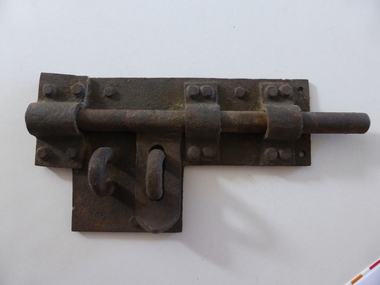
This lock was once used in the old 19th century gaol in Gilles Street, Warrnambool. The gaol is part of a group of four heritage buildings which comprise a police station, a police residence, police stables as well as the gaol. These were built between 1883 and 1888 from the designs of the Victorian Public Works Department architect, E.R. Laver. He was responsible for the designs of many 19th century country police stations, post offices and courthouses in Victoria. The four heritage buildings, of which the gaol is one, are important because they are some of the few surviving Warrnambool 19th century bluestone buildings. Today they form part of the South West Tafe Complex. This lock is of considerable interest as one used in the Warrnambool 19th century gaol building. The door on which it was used appears to be walled up now. This is a large iron lock with a base plate with three rivets and a projection piece. There are three curved iron pieces on the plate and these are fixed to the plate with 12 rivets. The bolt is rounded and moves under the three curved pieces across the plate. There are two other curved pieces, part of the bolt locking system. The lock has surface rust. warrnambool police and gaol heritage buildings, history of warrnambool -
 Greensborough Historical Society
Article, Journal, Australian Home Beautiful, Lower Plenty State School LP1295, 20/06/1921o
The Australian Home Beautiful article on the Heidelberg and Eastern Golf Club indicates that its clubhouse comprised two buildings, "Bryn Teg" built by Mrs Thomas, one approximately 1849, the other 40 years later. The club moved into these buildings about 1928. The stables were converted for use in 1921 by Frederick Henry Gilsenan as the Lower Plenty State School No. 1295 which was open from 20/06/1921 to 11/04/1925. Mr. Gilsenan married Margaret Mar Cornall in 1923. They lived in Heidelberg, had a daughter, Verna in 1924. Mr Gilsenan was transferred to Mt Moriac SS No. 1608 in 1925. The handwritten account is written by Verna.Historical significance about the premises of both the Lower Plenty State School and the Heidelberg Golf Club.4 p. photocopied article from Australian Home Beautiful 1 June 1929, with 2p.handwritten history of the school 20/06/1921-11/04/1925 (2 copies) and page of photographs of building and people.lower plenty primary school, gilsenan, frederick henry, heidelberg golf club -
 Hume City Civic Collection
Photograph, Aitkens Gap Police Barracks, c1922
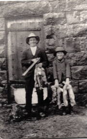
Frank Millett and his nephew Hopper Cahill are the two people standing by the building after spending the day shooting rabbits in 1922. They are standing in front of the Aitkens Gap Police Barracks. In the 1860s the gaol and stables were sold to George Millett and added to the Millett property. The Barracks and the new farm homestead were built by Mick Morrison. The Bald Hill Hotel at Aitkens Gap on the Bendigo Road (Calder Highway) was guilt by George Millett in 1854 and functioned until the gold began to run out after the Victorian Gold Rush of the 1850s. The Millett family continued to farm until 1967. The family also and operated hotels in the local area. A black and white photograph backed onto a white board of a man and a child holding some dead rabbits and standing in front of the doorway of a bluestone building. frank millett, george millett, aitkens gap gaol, hopper cahill -
 Port Fairy Historical Society Museum and Archives
Photograph
In 1844 a carpenter called David McLaws secured the lease on the land on the south west corner of James and Bank Streets. He later converted this to freehold by which time he had erected the Caledonian Inn. This building has been continually licensed since that time , and is believed to be the longest continual license held in Victoria. The dormer windows in the part of the building facing James street hide the fact that there is only a skeleton of rooms that were meant to be built there. They were unfinished because the labourers left town when gold was discovered at Ballarat in 1853. An advertisement for the time says “There were four parlours, a bagatelle room, eight bedrooms, a detached kitchen, stable and kitchen garden”. Well known hotel Thought to be the oldest continuously licenced hotel in VictoriaBlack and white photograph of 2 story building with dormer windows on corner hotel, building, james street, bank street, david mclaws -
 Port Fairy Historical Society Museum and Archives
Photograph
In 1844 a carpenter called David McLaws secured the lease on the land on the south west corner of James and Bank Streets. He later converted this to freehold by which time he had erected the Caledonian Inn. This building has been continually licensed since that time , and is believed to be the longest continual license held in Victoria. The dormer windows in the part of the building facing James street hide the fact that there is only a skeleton of rooms that were meant to be built there. They were unfinished because the labourers left town when gold was discovered at Ballarat in 1853. An advertisement for the time says “There were four parlours, a bagatelle room, eight bedrooms, a detached kitchen, stable and kitchen garden”. Well known Hotel thought to be the longest continuous licenced hotel in VictoriaBlack and white photographhotel, bank street, port fairy, james street, building -
 Port Fairy Historical Society Museum and Archives
Postcard - Photograph, Seacombe House Port Fairy
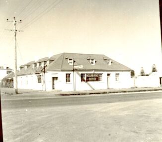
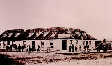
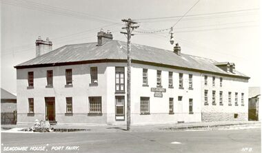
Seacombe House Formerly named The Stag Cnr Sackville and Cox Streets Port Fairy John Sanders (Saunders) first came to Port Fairy in charge of the "Sally Ann" owned by the Henty family of Portland. He left the sea behind in 1844 and established the "Sally Ann Inn" named for his old ship, on the site of the present day Star of the West hotel. After selling the Sally Ann Inn to John Taylor he acquired the land on the South west corner of Sackville Street and erected a detached cottage facing Sackville Street for which he obtained a licence to sell alcohol and named the premises The Stag Inn. He died in 1850 and his wife leased the Inn to John Mason. By 1852 a large two story rendered bluestone building had been constructed on the corner site. The second un rendered section was probably added in 1854. Abijah John Brown became licencee in 1855 and made the Stag the centre of entertainment for the district, with many balls, dinners and concerts taking place there. It boasted "a billiard room and a twenty stall stables and coach house". By 1861 Abijah Brown had left The Stag and Lennox Trew was now owner and licencee. It came up for sale in 1869 but failed to sell. After Trew's death in 1886 it was sold to a syndicate and opened as a boarding school. It later became a Coffee Palace and Accomodation house named Seacombe House, and in the 1950's a motel was built on the old stable site. It is still a Hotel Motel and a restaurant which has revived the old name of "The Stag". Black and white Photograph of 2 story rendered building with multi paned windows and power pole on cornerhotel, lennox trew, abijah brown, john sanders, john saunders, john mason., sackville street, cox street, stag inn, stag hotel, seacombe house, coffee palace -
 Eltham District Historical Society Inc
Photograph, Jim Connor, Shillinglaw Cottage, Panther Place, Eltham, 17 Aug 2015
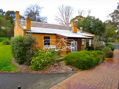
Shillinglaw Cottage looks stable enough now but it was the first colonial building in Australia to be pulled apart brick by brick and reconstructed on a different site. Community outrage prevented the council from demolishing the cottage in 1963 to make way for Eltham’s Shire Offices and local people paid for the cottage to be moved. Originally built by respected local builder George Stebbing in 1859, the cottage is typical of European farmhouses, but is constructed of handmade local bricks in a style known as “Flemish Bond.” The chequered pattern created by the burnt “header” bricks is a unique feature of this style. The cottage’s name comes from its long association with the Shillinglaw family, who loved there for more than eighty years. The Cottage is classified by the National Trust. Tomorrow's history documented todayeltham, jim connor collection, main road, shillinglaw cottage -
 Eltham District Historical Society Inc
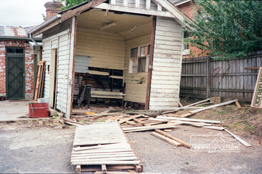
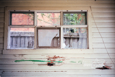
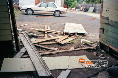
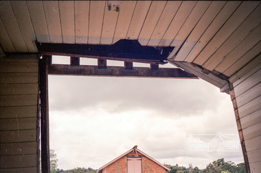
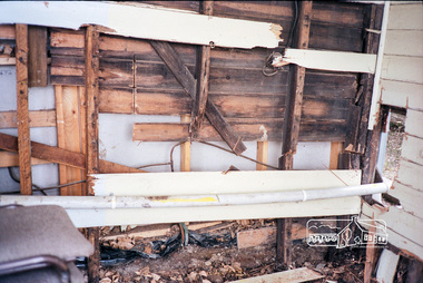
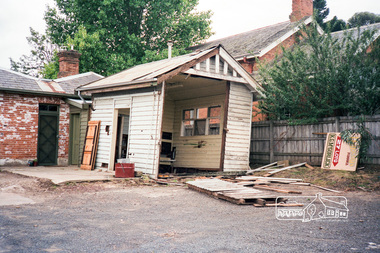
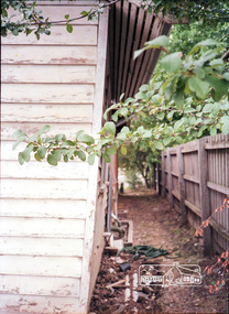
Photograph, The former Police residence at 728 Main Road under renovation work for future Shire of Eltham use, c.Nov. 1991
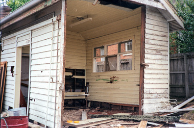
The original Eltham Police Station was used up till about 1960. The building was then taken over and used by the Vermin and Noxious weeds Destruction Section of the Department of Crown Lands and Survey. They vacated the building c.March 1981 and it remained unoccupied for a period of time whilst its future was discussed in Council. About 1986 the Shire took over use of the Police Residence and renovated it for use by the Shire Parks and Environment Office. The original Police Station was termite infested and was removed. It was later replaced by a replica building which was used as a lunchroom for Council employees working at the site. Based on photos contained in the 1992 Bick Heritage Study of the Police Residence and Stable, this roll of film was taken Nov 1991.Roll of 35mm colour negative film, 7 stripsKodak GA 100 5095shire of eltham, justice precinct, police residence, police station, local history centre -
 Eltham District Historical Society Inc
Photograph, The former Police residence at 728 Main Road under renovation work for future Shire of Eltham use, c.Nov. 1991
The original Eltham Police Station was used up till about 1960. The building was then taken over and used by the Vermin and Noxious weeds Destruction Section of the Department of Crown Lands and Survey. They vacated the building c.March 1981 and it remained unoccupied for a period of time whilst its future was discussed in Council. About 1986 the Shire took over use of the Police Residence and renovated it for use by the Shire Parks and Environment Office. The original Police Station was termite infested and was removed. It was later replaced by a replica building which was used as a lunchroom for Council employees working at the site. Based on photos contained in the 1992 Bick Heritage Study of the Police Residence and Stable, this roll of film was taken Nov 1991.Roll of 35mm colour negative film, 7 stripsKodak GA 100 5095shire of eltham, justice precinct, police residence, police station, local history centre -
 8th/13th Victorian Mounted Rifles Regimental Collection
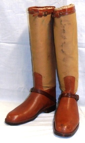
boots, 1930 circa
Officer's stable boot worn by Brigadier Geoffrey Austin Street MC who served in WWI at Gallipoli and on the Western Front. Following the war he was placed on the Reserve of Officers. He returned to military service in 1931 as Squadron Commander in the 4th Light Horse. He was promoted to the command of the regiment after l8 months' service, and finally to the command of the Third Cavalry Brigade which included the 8th Light Horse Regiment. Brigadier Street had entered Federal Parliament in 1934 and in November 1938 was seconded from military duties to serve as Minister for Defence in the Lyons Government . He was serving in this capacity in the Menzies government when he was killed in an air crash near Canberra on 13 August 1940.Representative example of officer's stable boots from the 'between the wars' period. Well preserved example of the boot makers art, complete and in good condition. Owned by well known Australian soldier and politician tragically killed at commencement of Second World War.Leather and canvas boots with leather boot and canvas upper calf legging. Leather strap at instep and leather stiffened back seam to canvas section; Leather edging at top of canvas upper legging together with adjustable strap. Foot of boot is stabilised by a metal 'Dasco' insert. On metal heal protector "704603"boot, street geoffrey a brigadier -
 Parks Victoria - Mount Buffalo Chalet
Honour Board
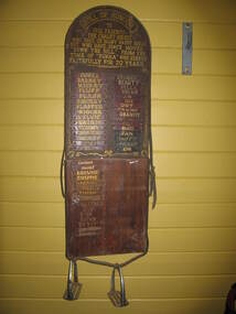
Was located in the stables at Mount Buffalo Chalet. It was used to record the names of horses that were ridden by Chalet guests when they were holidaying at the Chalet. 'Admiring the rugged beauty of the Buffalo Plateau and exploring its scenic attractions ...quickly became part of the Mount Buffalo Chalet tourist experience...The Chalet facilitated the experience by hosting guided tours, including trail rides on horseback...the horses remained at the Chalet for decades, and have been remembered with great affection, as demonstrated by the honour roll for Chalet horses and various commemorative plaques.' (Pg 98. Historica) Many of these horses are still remmbered by former guest of the Chalet. Granite and Punka were legendary and plaques in their honor are mounted on the large granite boulders in the stableyards.Listed in Draft Inventory of Significant Collection items. Appendix A.3, Snow sports equipment and other recreational items. (Pg 166 Historica).Wooden plaque with names painted onto strips of leather fixed to a board. The board is made of two sections of wood and is arched at the top and squared at the base. The piece at the top that appears to be earlier and has gold painted inscriptions with decorative scrolling around the edge. The board has leather strapping around the edge and two stirrups threaded onto leather at the base. The upper section of the board has all the names painted onto leather strips. The lower section of the board has some names painted onto strips but also some names are scratched directly onto the wood.At top of plaque, "ROLL OF HONOUR /TO / OUR FRIENDS - / THE CHALET HORSES, / WHO GAVE US MANY HAPPY HOURS / BUT WHO HAVE SINCE MOVED / "DOWN THE HILL". FROM THE / TIME OF "PUNKA" / WHO SERVED / FAITHFULLY FOR 20 YEARS" Underneat this are the names of the individual horses starting with , "PUNKA....." -
Glen Eira Historical Society
Document - Urandaline, Glen Eira Road, 434, Caulfield
... Stables ...Handwritten, unattributed, undated research on Urandaline. Handwritten copy of advertisement, published in The Argus, dated August 17 1889 of Urandaline. Article gives detail on house interior, rooms and out offices and property acreage.stables, glen eira road, bambra road, kambrook road, lloyd chas. d., urandaline, hospitals, caulfield station, ham c.j., ham t., architectural features, caulfield racecourse, mansions -
Glen Eira Historical Society
Document - Cambria
... Stables ...One page of, undated, unattributed notes on Cambria giving dates relating to Cambria including the date it was built, description of Cambria’s structure and the address of the foundry where the gates for Cambria were manufactured.cambria, presentation covent, davis george, neerim road, roseberry grove, booran road, mansions, stables, convents, towers, verandah, broadcasting, glen huntly -
Glen Eira Historical Society
Newspaper - St. Georges Road, 50, Elsternwick
... Stables ...This file contains two items about this property: 1/Bayside Weekly article dated February 2009 giving information about general type of houses in the street, types of building material and roof styles used. Description of house and its outside buildings and interior features. 2/Research by Claire Barton taken from Sands and McDougalls on occupiers of 50 St. Georges Road. from selected volumes 1903-1970.st. georges road, elsternwick, glen huntly road, brick, plaster moulds, architectural styles, smith robert, bond fredk w., stables, leadlights, verandahs, 'turlee', eddie f.f. -
 The Beechworth Burke Museum Research Collection
Card (Series) - Index Card, George Tibbits, Corner of Ford and Church Streets, Beechworth, 1976
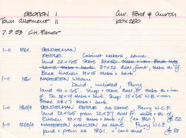
George Tibbits, University of Melbourne. Faculty of Architecture, Building and Town & Regional PlanningIndex system that support the research for Beechworth : historical reconstruction / [by] George Tibbits ... [et al]Arranged by street names of BeechworthEach index card includes: street name and number of property, image of property, allotment and section number, property owners and dates of ownership, description of the property according to rate records, property floor plan with dimensions.beechworth, george tibbitsbeechworth, george tibbits -
 Eltham District Historical Society Inc
Document - Property Binder, Eltham Lower Park, Main Road, Eltham
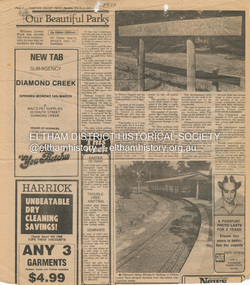
Newspaper article: Our Beautiful Parks, Diamond Valley News, 8 March 1983, describing Eltham Lower Park and Diamond Valley Miniature Railway. Newspaper article: Diamond Valley News, 8 March 1983, Election of the ALP, Peter Stables member for Diamond Valley. Flier for Diamond Valley Miniature Railway with photograph and map. Photographs of Miniature Railway at former location at Chelsworth Park Ivanhoe. Newspaper article: New BBQ at Eltham Park, The Advertiser, 9 July 1996, about a joint project between Nillumbik Council and Eltham Rotary (On same page an article about the showcasing of indigineous plants around Nillumbik Shire offices at Civic Drive and on p4 an article about redevelopment works at Elis Cottage).main road, parks, miniature railway, chelsworth park ivanhoe, bbq facilities, civic drive, eltham lower park, eltham rotary, landscape, nillumbik shire council, ellis cottage, eltham (vic), chelsworth park, ivanhoe, diamond valley railway