Showing 645 items
matching 1 yarra street
-
 Robin Boyd Foundation
Slide, Stock image
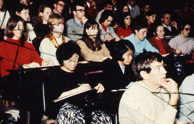
Colour slide in a mount. People in lecture theatreCMAS BLACKMAN THEATRE PARTY / 45X4 1/2 (All Handwritten and erased)slide, robin boyd -
 Robin Boyd Foundation
Slide, Robin Boyd, 1968
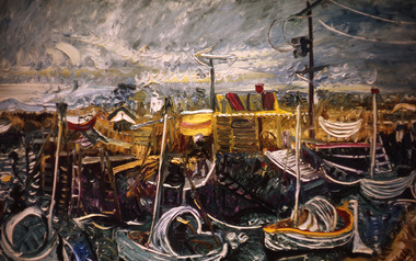
Colour slide in a mount. Oil painting by John PerceivalMade in Australia / 1 / APR 68M5slide, robin boyd -
 Robin Boyd Foundation
Slide, Robin Boyd, 1967
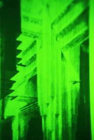
Colour slide in a mount. UnknownMade in Australia / 30 / JUN 67M1 / Encircled 1 (Handwritten) / 1 (Handwritten)slide, robin boyd -
 Robin Boyd Foundation
Slide, Robin Boyd, 1967
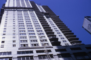
Colour slide in a mount. Skyscraper, unknown locationMade in Australia / 1 / JUN 67M6slide, robin boyd -
 Robin Boyd Foundation
Slide, Robin Boyd, 1971
Colour slide in a mount. Koi, unknown location, JapanMade in Australia / 1 / AUG 71M1slide, robin boyd -
 Robin Boyd Foundation
Slide, Robin Boyd, 1969
Robin Boyd travelled to the USA and Britain for several weeks. He attended the opening of the new Australian Chancery in Washington DC, where he had designed an innovative exhibition with cylindrical display cases and sound recordings.Colour slide in a mount. Thamesmead Estate, London, EnglandMade in Australia / 1 / JUN 69M2slide, robin boyd -
 Ambulance Victoria Museum
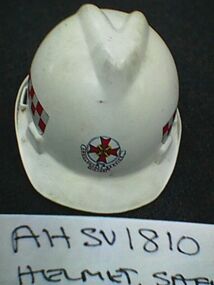
Helmet, Safety, Ambulance Service Victoria
Worn by ambulance officers during rescue operations or other hazardous situations when there was risk of head injury. This helmet was used by ambulance officers based at Yarra Junction.White plastic helmetAmbulance Service Victoriayarra junction -
 Mt Dandenong & District Historical Society Inc.
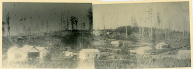
Photograph, Panorama of Olinda Sections 1 & 2 c1904
Parts 1 and 2 of a set of 4 photographs that are placed side by side to give a panorama of the Main Street of Olinda c1904. Old buildings clearly visible.No 1 of Panorama of Olinda 1904. No 2 of Panorama of Olinda 1904olinda, panorama -
 Mt Dandenong & District Historical Society Inc.
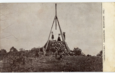
Photograph, "Observatory," Dandenong Mountains (Vic.), early 1900s
Postcard showing the Trig Point Observatory on Mt Dandenong. Two women and a man are standing on the rock base. Early 1900s.Printed on front of postcard: "OBSERVATORY," DANDENONG MOUNTAINS (VIC.) Printed on back of postcard: Photographed by ERASMUS B. ALLAN, Fitzroy ASK FOR Allan's "Guide to the Dandenong Mountains." Published Shortly. Price 1/- HUTCHINSON'S Lit. Collins Street Melbourne.mt dandenong, trig point, mt dandenong observatory, erasmus b allan -
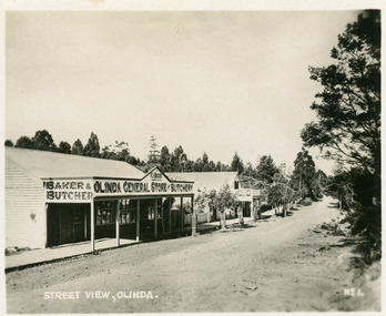 Mt Dandenong & District Historical Society Inc.
Photograph, Street View, Olinda, late 1930s
Number 1 in commercial series.Small photograph, number 1 in Olinda series, showing a view of the Main Street of Olinda late 1930s. V.J. Boulter's Olinda General Store with butcher and bakery in foreground. Road not yet made.boulter, v.j. boulter, general store, butcher, bakery, olinda -
 Melbourne Legacy
Furniture - Desk, Savige / Markham Desk, 1936
In his early years Stan Savige had a special friend, Perc Markham, with whom he grew up and attended South Yarra Baptist Church. Perc was rejected on medical grounds when he sought to enlist for service in World War 1. He worked with his father in the building business and established a reputation as a builder and renovator of houses. After the foundation of Legacy, Stan Savige utilised the services of Perc for Legacy tasks on a number of occasions. In token of this relationship, in about 1936, Stan Savige presented this desk to Perc Markham who used it until his death in 1978. The desk then passed into the care of Perc’s son, Lloyd, who perceived that it could be of both historical and sentimental value to Melbourne Legacy. He presented it to Legacy in November 1984 so that it may be used by those who have cause to respect the memory of one whose energies were devoted to the establishment and perpetuation of the Legacy movement. A desk with a direct link to Legacy's founder Legatee Stan Savige.A wooden roll top desk with internal shelves, two with slide out trays and 4 drawers down one side.Metal plaque engraved 'Presented to Melbourne Legacy, 31 October 1984 by Lloyd Markham, son of Perc Markham to whom it was given by Stan Savige in 1936.desk, savige, perc markham -
 Kew Historical Society Inc
Plan - Subdivision Plan, J R Mathers & McMillan, Heart of Richmond Estate : Richmond, 1928
"In 1928 the land on the east side of Johnson Street was subdivided in 60 lots for the ‘Heart of Richmond Estate’. The houses in the subdivision, along the east side of Johnson Street, and in the newly created Hollick, Cole and Kennedy streets were constructed from 1928 to 1937." (Source: City of Yarra Heritage Gaps Review One 2013)Portion of subdivision plan pasted on to cardboard. Area includes Johnson Street, Victoria Street, Kennedy Street, Cole Street, Hollick Street, Bennett StreetTitle Certificate Vol.2381, Folio 476130 Phillips, Fox & Masel, 440 Little Collins Street, Melbourne (Local estate agent: Jas. R. Mathers & McMIllan, 136 Cotham Road, Kew)subdivision plans - richmond (vic.), heart of richmond estate -
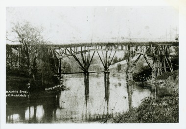
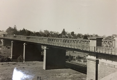 Kew Historical Society Inc
Photograph, Outer Circle Railway Viaduct, 1919
Railway Viaduct constructed for the Outer Circle Railway. Bridge designed by John Monash, engineer. Converted into a state highway, 1930s.Dateable photo of an important piece of Victorian railway infrastructure.Photograph of Outer Circle Railway Bridge over River Yarra, Fairfield. Looking toward Lugton Street, showing fence underneath taken from the Chandler Highway. Reverse: "Outer Circle Railway Bridge over River Yarra Fairfield, H0276, Property of Miss Foley"railway viaduct, chandler highway -
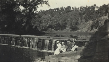 Kew Historical Society Inc
Photograph, Richardson Family at Dight's Falls, 1920
Dight’s Falls in Studley Park is an artificial weir built on a natural rock bar across the Yarra. The weir was built in the 1840s to provide water to the ‘Ceres’ flour-mill, one of the first in Victoria. The falls were later to become known as Dight’s Falls after the owners of the mill. Later, a pumping station was built on the Kew side of the river, which pumped water uphill to a reservoir in Walmer Street that provided water to the Melbourne Botanical Gardens and to Albert Park Lake. The area around Dight’s Falls was and is frequently used for recreational activities.This photograph forms part of the collection assembled by the historian Dorothy Rogers, that was donated to the Kew Historical Society by her son John Rogers in 2015. The manuscripts, photographs, maps, and documents were sourced by her from both family and local collections or produced as references for her print publications. Many were directly used by Rogers in writing ‘Lovely Old Homes of Kew’ (1961) and 'A History of Kew' (1973), or the numerous articles on local history that she produced for suburban newspapers. Most of the photographs in the collection include detailed annotations in her hand. The Rogers Collection provides a comprehensive insight into the working habits of a historian in the 1960s and 1970s. Together it forms the largest privately-donated collection within the archives of the Kew Historical Society.Black and white photograph of the Richardson family seated on the Kew side of Dight's Falls in 1920. One of the girls in the photograph was to become the Melbourne historian Dorothy (Richardson) Rogers.Annotation on reverse: "Mrs D. Rogers, 29 Park Crst Kew. Dights Falls 1920"dight's falls - kew (vic) - fairfield (vic), sport and recreation - kew (vic), dorothy rogers -
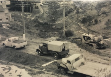 Kew Historical Society Inc
Photograph, C Stuart Tompkins ARPS, Construction of Stawell and Yarra Streets, 1956
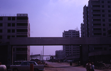
Yarra Street in the Studley Park section of Kew was subdivided in the 1940s and 1950sSmall black and white photograph looking north-west down Yarra Street, Kew from upper Stawell Street during street construction in 1956. Homes at 32 Stawell Street and 5 Yarra Street are partially visible on left.yarra street (kew) -
 Kew Historical Society Inc
Archive (Sub-series) - Subject File, Bowling Clubs, 1958
Various partiesReference, Research, InformationKHS OrderSubject file containing correspondence relating to the former Studley Park Bowling Club in Barry Street, Kew and its relocation to Yarra Bend Park. The file includes a photocopy of the letter by Nigel Lewis to the City of Kew, describing the historic importance of the Club (established c.1903) and the necessity of moving it before demolition. The file has information relating to the pavilion’s move and restoration as an art centre. [ KHS also holds the complete archives of the Auburn Heights Recreation Club (1904-98), the Kew Bowling Club (1880-1998) and the Kew Heights Sports Club (1998-2012). These are separate archives in Provenance Order].sports clubs - kew (vic.), studley park bowling club, urban conservation, heritage protectionsports clubs - kew (vic.), studley park bowling club, urban conservation, heritage protection -
Kew Historical Society Inc
Archive (Sub-series) - Subject File, Bridges (Kew), 1958-present
Various partiesReference, Research, InformationSecondary Values (KHS Imposed Order)Subject file containing information relating to each of the bridges crossing the Yarra In Kew. The file includes correspondence, photocopied photographs and maps, journal articles, research, and printed ephemera. Bridges referred to and described in the file include Kanes Bridge, Walmer Street Foot Bridge, Johnston Street Bridge, Chandler Bridge, Collins Bridge, Tramway or Zig Zag Bridge, Penny Toll Bridge, Victoria Street Bridge, Burke Road Bridge. The file includes original materials relating to the Victoria Street Bridge Centenary Celebration 1884-1984 -
Kew Historical Society Inc
Archive (Sub-series) - Subject File, 'Fairview', 34 Wrixon Street (Kew), 1979
Various partiesReference, Research, InformationSecondary Values (KHS Imposed Order)Subject file containing information about Fairview (built 1924 for F.F. Robinson, proprietor of Yarra Falls Mills). The house replaced an earlier single-storey brick house, also called Fairview. A comprehensive report prepared by Alan Willingham in 2006 found that there was no evidence that the architect Desbrowe-Annear incorporated parts of the original building in the new construction. The work by Willingham is a ‘Cultural and Architectural History and Assessment of the Cultural Heritage Significance’ of the building, prepared for Carey Grammar School. The Willingham report was donated by Sr Ruth Anderson.kew (vic) - history, fairview - 34 wrixon street - kew (vic), cluny house - 34 wrixon street - kew (vic), f.f. robinson, alan willingham, harold desbrowe-annearkew (vic) - history, fairview - 34 wrixon street - kew (vic), cluny house - 34 wrixon street - kew (vic), f.f. robinson, alan willingham, harold desbrowe-annear -
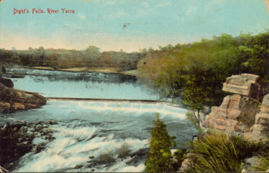 Kew Historical Society Inc
Postcard - Dight's Falls, River Yarra, c.1911
Dight’s Falls in Studley Park is an artificial weir built on a natural rock bar across the Yarra. The weir was built in the 1840s to provide water to the ‘Ceres’ flour-mill, one of the first in Victoria. The falls were later to become known as Dight’s Falls after the owners of the mill. Later, a pumping station was built on the Kew side of the river, which pumped water uphill to a reservoir in Walmer Street that provided water to the Melbourne Botanical Gardens and to Albert Park Lake. The area around Dight’s Falls was and is frequently used for recreational activities.Dated postcard allowing one to analyse the form of the Falls in 1911Colour postcard, of Dight's Falls on the River Yarra between Kew and Fairfield. The photograph is taken looking upstream towards the Falls from the Kew side, from the embankment in the vicinity of the Pumping Station. Obverse: "Dight's falls, Kew" Reverse: "Printed in Great Britain Writing in ink on Reverse: "31/3/1911 / To dear Nell with best wishes for a happy birthday from your old friend Eve / [Addressed to] "Mrs N Dunn, Prahran" Franked Victorian 1d stamp on Reverse top rightdight's falls, dight's falls - kew (vic) - fairfield (vic) -
 Kew Historical Society Inc
Photograph - Second Johnston Street Bridge in Flood, 1934
Original, small black and white print photograph of crowds lining the Johnston Street Bridge watching the flood waters below. The annotation on the reverse clarifies that Kew is in the distance.Annotated on reverse: "Gift of G.S. Beard / 2nd bridge / Johnston St. Studly Park Rd. Bridge looking towards Kew / 1st bridge 1858–1876, 2nd bridge built (bad bend), 1876–1958, 3rd bridge 1958, lined up Johnston St and Studley Park Rd."johnston street bridge, bridges - yarra river -- kew (vic.), flood -- 1934 -
 Kew Historical Society Inc
Print, Studley Pk Toll Bridge, July 12 1899
Black and white print photograph of the wooden 'Penny Bridge' at Studley Park. The name was colloquially arrived at as a penny wa the toll one paid to cross the bridge. The copy of the postcard identifies the photographers as McAlpin Bros, Richmond.Reverse: "Studley Pk Toll Bridge / joining Church Street Abbotsford / Penny Bridge"toll bridges -- river yarra, bridges - yarra river -- kew (vic.), penny bridge -
 Kew Historical Society Inc
Print - Walmer Street Foot Bridge
A bridge to Walmer Street, Kew, from Abbotsford was located at the northern end of Burnley Street. It was a foot bridge.Photographic print of the Walmer Street Bridge. The view of the Bridge is from the Abbotsford side of the Yarra. A section of pipe on the near side of the bridge is a remnant of the irrigation pipes that carried water from above Dight's falls to the Melbourne Botanic Gardens. The former bridge, constructed in 1896 was swept away in the 1901 Flood. It has two major brick piers while the remainder of the trestle supports are metal. The original photograph from which this copy was made was taken after 1901 as it shows the second bridge under construction. Houses in Young Street, Kew, can be seen on the far side of the river.Written on reverse: "Walmer St. Bridge. Erected 1896. Being rebuilt after 1901 flood damaged it. Houses on left are in Young St."bridges -- kew (vic.), walmer street bridge, melbourne botanic gardens -
 Kew Historical Society Inc
Print - Walmer Street Foot Bridge, 1901
Photographic print of the Walmer Street Bridge. The view of the Bridge is from the Abbotsford side of the Yarra. A section of pipe on the near side of the bridge is a remnant of the irrigation pipes that carried water from above Dight's falls to the Melbourne Botanic Gardens. The former bridge, constructed in 1896 was swept away in the 1901 Flood. It has two major brick piers while the remainder of the trestle supports are metal. The original photograph from which this copy was made was taken after 1901 as it shows the second bridge under construction. Houses in Young Street, Kew, can be seen on the far side of the river.Reverse: " Walmer St footbridge 1901 being repaired after flood / Constructed 1892 substantially renewed in 1901 and in 1928 / Rebuilt in 1977 by Kew Council aided by State funding. Won for designer Martin Aylard a New Zealand award presented by the timber Research & Development Assoc / Site of Simpsons Road passenger foot ferry". bridges - yarra river -- kew (vic.), walmer street bridge -- kew (vic.) -
 Kew Historical Society Inc
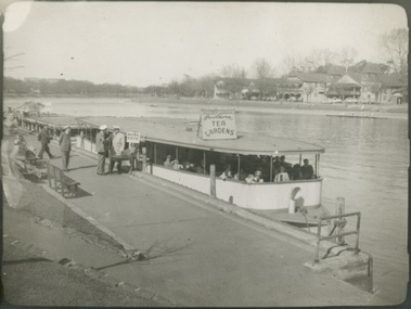
Photograph - Hicks' Cruiser berthed on the Yarra at Princess Bridge, c.1953
Commercially-operated boat tours on the Maribyrnong and Yarra Rivers in Melbourne were a major tourist attraction, especially in the first half of the twentieth century. A number of companies ran ferries and motor-launches to locations such as the Riverview Tea Gardens (1909-1947) at Ascot Vale, and the Hawthorn Tea Gardens on the corner of Power Street and Riversdale Road. One of the families which ran these services was Hicks Bros, which from circa 1921 operated a ferry service from Princess Walk (Melbourne) to Studley Park. This is one of a series of 17 black and white undated photographic proofs donated to the Kew Historical Society in 2013 by the Queenscliffe Historical Museum. The series includes images of individuals, tea rooms, ferries, motor launches, ocean liners and tugs. In 1953, the owner of Hicks Bros was involved in an inquest into the drowning of a Ukrainian tourist on a ferry operated by Melbourne Ferries, a rival firm. In published reports of the inquest, reference is made to a number of photographs taken by Robert Irvine Atchison, part-owner of Hicks Bros. As the reverse of the photographs indicates copyright is held by the State of Victoria, the collection may have derived from that year.Black and white print of a tourist cruiser berthed on the River Yarra at Princess Bridge. The sign on the cruiser says 'Tea Gardens' so its destination may have been the Hawthorn Tea Gardens. The single story, wide barge like roofed ferry has passengers on board. The ticket seller can be seen beside the boat on the moorings. tourism -- melbourne (vic.), ferries, yarra river, hick's cruises, hawthorn tea gardens -
 Kew Historical Society Inc
Photograph - Hicks' Cruises ticket seller at Princess Bridge, c.1953
Commercially-operated boat tours on the Maribyrnong and Yarra Rivers in Melbourne were a major tourist attraction, especially in the first half of the twentieth century. A number of companies ran ferries and motor-launches to locations such as the Riverview Tea Gardens (1909-1947) at Ascot Vale, and the Hawthorn Tea Gardens on the corner of Power Street and Riversdale Road. One of the families which ran these services was Hicks Bros, which from circa 1921 operated a ferry service from Princess Walk (Melbourne) to Studley Park. This is one of a series of 17 black and white undated photographic proofs donated to the Kew Historical Society in 2013 by the Queenscliffe Historical Museum. The series includes images of individuals, tea rooms, ferries, motor launches, ocean liners and tugs. In 1953, the owner of Hicks Bros was involved in an inquest into the drowning of a Ukrainian tourist on a ferry operated by Melbourne Ferries, a rival firm. In published reports of the inquest, reference is made to a number of photographs taken by Robert Irvine Atchison, part-owner of Hicks Bros. As the reverse of the photographs indicates copyright is held by the State of Victoria, the collection may have derived from that year.Closeup photograph of a ticket seller touting for business for a tourist ferry moored at Princess Bridge The sign on the boat identifies the destination of the ferry as 'Studley Park via Hawthorn Tea Gardens'. The ferry is empty of passengers.hicks' cruises, tourism -- melbourne (vic.), river yarra, studley park, hawthorn tea gardens -
 Kew Historical Society Inc
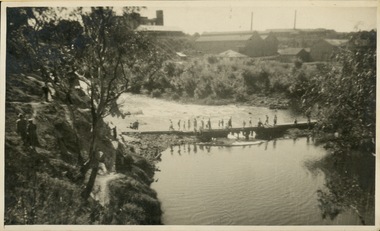
Photograph - Crossing Dights' Falls on the Yarra by foot
Dight’s Falls in Studley Park is an artificial weir built on a natural rock bar across the Yarra. The weir was built in the 1840s to provide water to the ‘Ceres’ flour-mill, one of the first in Victoria. The falls were later to become known as Dight’s Falls after the owners of the mill. Later, a pumping station was built on the Kew side of the river, which pumped water uphill to a reservoir in Walmer Street that provided water to the Melbourne Botanical Gardens and to Albert Park Lake. The area around Dight’s Falls was and is frequently used for recreational activities.Rare original print photograph of people walking across Dight's Falls when the river flow was low. View west towards Abbotsford. Photograph taken from Kew side of river above the Falls.Reverse: "M Holmes"dight's falls, river yarra -- kew - abbotsford -
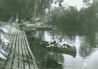 Kew Historical Society Inc
Photograph - Canoeing at Macauley's Boathouse, 1950s
Macauley's boat sheds (aka Kew Boatsheds) was located on the river at the western end of Molesworth Street, Kew.Black and white enlargement. Two children pictured in a canoe at Macauley's Boathouse on the River Yarra at Studley Park.Reverse: "Macauley's Boatsheds / M Holmes"boathouses -- river yarra, boathouses -- kew, macauley's boat shed, recreation -- canoeing -
 Kew Historical Society Inc
Photograph - Flooding of the Yarra River in North Kew, 1934
North Kew, now divided between Kew and Kew East, bordered the Yarra River. As such, it was a region subject to flooding in the Yarra Valley. Development beyond this point (ie Kellett Grove) was limited by the City of Kew's planning regulations. Prior to urban development, the area since European settlement and the first land sales in the district in the 1840s, had been used for dairy farming. .Small sepia snapshot of what was then River Avenue, North Kew submerged by floodwaters.The photo was taken in the vicinity of 8 Kellett Grove, North Kew. Verso: TAKEN FROM OUR STREET JUST SEE A BIT OF RYAN'S FENCE / 1934yarra river -- north kew, floods -- yarra valley, floods -- north kew, floods -- 1934, natural disasters -- kew -
 Kew Historical Society Inc
Photograph - Flooding of the Yarra River in North Kew, 1934
North Kew, now divided between Kew and Kew East, bordered the Yarra River. As such, it was a region subject to flooding in the Yarra Valley. Development beyond this point (ie Kellett Grove) was limited by the City of Kew's planning regulations. Prior to urban development, the area since European settlement and the first land sales in the district in the 1840s, had been used for dairy farming. .Small sepia snapshot of the devastation caused by the 1934 flood.The photo was taken in the vicinity of Kellett Grove, North Kew and includes the roof of Chipperfield's Boathouse as well as other local houses.Verso: THIS IS CHIPPERFIELD'S BOAT SHEDS & COES & WILLIAMS TAKEN FROM OUR STREET / 1934yarra river -- north kew, floods -- yarra valley, floods -- north kew, floods -- 1934, natural disasters -- kew, chipperfields boathouse -
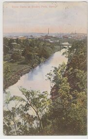 Kew Historical Society Inc
Postcard, River Yarra at Studley Park, Kew, c.1908
Colour-tinted postcard, titled in red upper left: “RIVER YARRA AT STUDLEY PARK, KEW”. On the divided reverse, the card is addressed to “MISS JOLLEY / MELB. TRAM & O[MNIBUS]. CO / BOURKE STREET, MELB”. The sender has dated the card 21.12.08. In the upper right corner, there is a pink Victorian one penny postage stamp; sent from Melbourne on 22DE 08. (The division of the reverse of the postcard, allowing a message to be written on one half and the address on the other, was not permitted in Australia until 1905.) The manufacturer of the postcard is indicated by the initials “W.T.P”, printed in a green floral diamond, printed centre top. This was the trademark of WT Pater, printers & stationers. William Thompson Pater was born in Melbourne in 1861. His business at 271 Little Collins Street offered Christmas cards, booklets, calendars, and leather goods as well as postcards and albums.Hand-tinted postcard of the River Yarra in Studley Park, Kew. The birds-eye view is of a bridge on the Yarra (Johnston Street?) linking Kew and Abbotsford as it appeared in c.1908. On the Abbotsford side of the river, fields lead down to the river, with some remnant trees. The Kew side of the river, in contrast, due to its steep banks, retains its original vegetation. In the distance is industrial development, in what might be Fairfield and Alphington.“RIVER YARRA AT STUDLEY PARK, KEW”river yarra -- kew (vic.), william thompson pater, w.t.p., postcards -- kew, postcards -- studley park, bridges - yarra river -- kew (vic.)