Showing 1506 items matching "acres"
-
 Eltham District Historical Society Inc
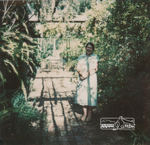
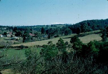
Work on paper (item) - Photograph, 2 Metery Road, Eltham South
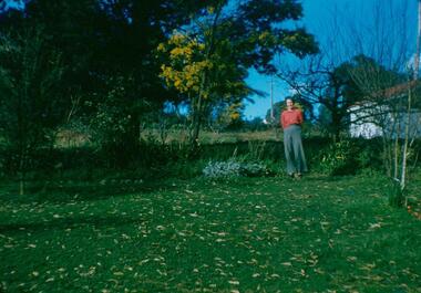
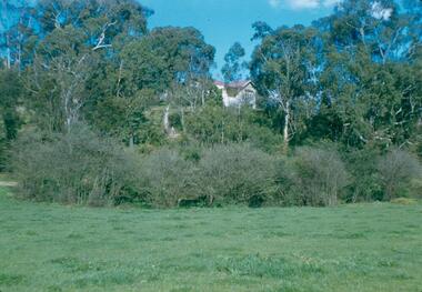
Robert and Ada Zull built an Alistair Knox designed house at 2 (lot 8) Metery Road, Eltham, a one acre property for their family of five in the mid 1960s. Susan Bennett, nee Zull's reminiscences are published in EDHS Newsletter, February, April, June, August 2020. This series of photographs together with the account of personal remiscences provide a unique document of the construction of an Alistair Knox designed home. Knox was a pioneer in the use of mudbricks and recycled materials and is significant to his contribution of this style of architecture in Eltham and the wider Shire of Nillumbik.zull family, eltham south, 2 metery road, alistair knox, bush block -
 Eltham District Historical Society Inc
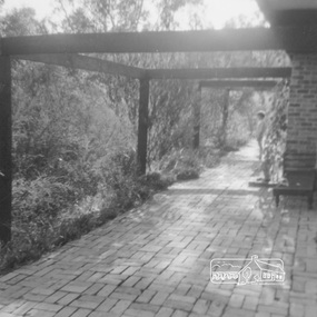
Work on paper (item) - Photograph, 2 Metery Road, Eltham South
Robert and Ada Zull built an Alistair Knox designed house at 2 (lot 8) Metery Road, Eltham, a one acre property for their family of five in the mid 1960s. Susan Bennett, nee Zull's reminiscences are published in EDHS Newsletter, February, April, June, August 2020. This series of photographs together with the account of personal remiscences provide a unique document of the construction of an Alistair Knox designed home. Knox was a pioneer in the use of mudbricks and recycled materials and is significant to his contribution of this style of architecture in Eltham and the wider Shire of Nillumbik.zull family, eltham south, 2 metery road, alistair knox, bush block -
 Eltham District Historical Society Inc
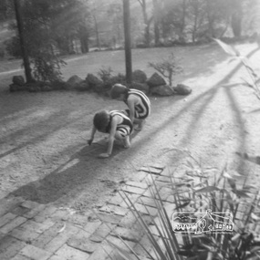
Work on paper (item) - Photograph, 2 Metery Road, Eltham South
Robert and Ada Zull built an Alistair Knox designed house at 2 (lot 8) Metery Road, Eltham, a one acre property for their family of five in the mid 1960s. Susan Bennett, nee Zull's reminiscences are published in EDHS Newsletter, February, April, June, August 2020. This series of photographs together with the account of personal remiscences provide a unique document of the construction of an Alistair Knox designed home. Knox was a pioneer in the use of mudbricks and recycled materials and is significant to his contribution of this style of architecture in Eltham and the wider Shire of Nillumbik.zull family, eltham south, 2 metery road, alistair knox, bush block -
 Greensborough Historical Society
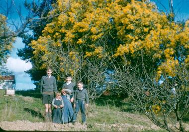
Photograph - Digital Image, Blackjack: five boys in the garden, wattle flowering, 1953_
Five boys in the garden at Blackjack, the home of the Robinson family to late 1956. The Blackjack property, house and acres of fruit orchards ran down to the Plenty River off Hume Street Greensborough. The photographs were taken as slides by Frank Robinson and digitised by his son James in 2015.Digital copy of colour photograph.blackjack, hume street greensborough, robinson family, frank robinson -
 Greensborough Historical Society
Photograph - Digital Image, Blackjack: Beb standing in the garden, 1953_
Beb standing in the garden at Blackjack, the home of the Robinson family to late 1956. The Blackjack property, house and acres of fruit orchards ran down to the Plenty River off Hume Street Greensborough. The photographs were taken as slides by Frank Robinson and digitised by his son James in 2015.Digital copy of colour photograph.robinson family, blackjack, hume street greensborough -
 Greensborough Historical Society
Photograph - Digital image, Frank Robinson, Greensborough Football Ground, 1956_
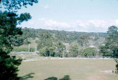
The Greensborough football ground 1956. The Blackjack property, house and acres of fruit orchards ran down to the Plenty River off Hume Street Greensborough and was the home of the Robinson family to late 1956. The photographs were taken as slides by Frank Robinson and digitised by his son James in 2015.Digital copy of colour photograph.frank robinson, greensborough football club -
 Greensborough Historical Society
Photograph - Digital Image, Blackjack from the north west, 1954_
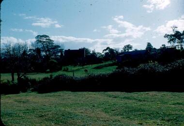
Blackjack from the north west. The Blackjack property, house and acres of fruit orchards ran down to the Plenty River off Hume Street Greensborough and was the home of the Robinson family to late 1956. The photographs were taken as slides by Frank Robinson and digitised by his son James in 2015.Digital copy of colour photograph.blackjack, robinson family -
 Greensborough Historical Society
Photograph - Digital Image, View of Greensborough near Blackjack, 1954_
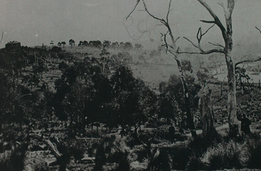
View of Greensborough near Blackjack. The Blackjack property, house and acres of fruit orchards ran down to the Plenty River off Hume Street Greensborough and was the home of the Robinson family to late 1956. The photographs were taken as slides by Frank Robinson and digitised by his son James in 2015.Digital copy of colour photograph.robinson family, blackjack -
 Greensborough Historical Society
Photograph - Digital Image, View of Blackjack near Greensborough, 1954_
View of Blackjack near Greensborough. The Blackjack property, house and acres of fruit orchards ran down to the Plenty River off Hume Street Greensborough and was the home of the Robinson family to late 1956. The photographs were taken as slides by Frank Robinson and digitised by his son James in 2015.Digital copy of colour photograph.robinson family, blackjack -
 Greensborough Historical Society
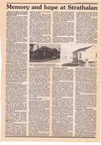
Newspaper clipping, Victorian Baptist Witness, Memory and hope at Strathalan, 1995_03
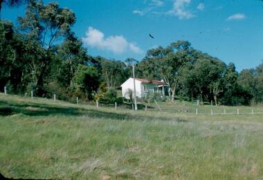
Review and extracts from "Memory and Hope", an 87 page history of Strathalan Baptist Home for the aged, by Damian X. Powell, from purchase in 1906/7 of the Strathalan homestead and 15 acres of land in Macleod by the Victorian Baptist Union to 1958 when further development of the site was halted.1 page, text and black and white images.strathalan baptist home for the aged, macleod -
 Warrnambool and District Historical Society Inc.
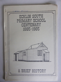
Booklet, Ecklin South Primary School 1885-1985, 1985
This is a short history of the Ecklin South Primary School from 1885 to 1985. Ecklin South is 37 kilometres from Warrnambool and 25 kilometres from Port Campbell. The school was established on a five acre site in 1885 with the first teacher, Andrew Harkness. A new building was erected in 1937.This booklet is of interest because it gives the history of a school in Ecklin South, a district not far from Warrnambool. It will be useful for research. This is a soft cover booklet of 28 pages produced in-house by Ecklin South Primary School Centenary Committee members.. The cover is a buff colour with a black, grey and white sketch of the school on the front. The history of the school is type-written and there are several black and white photographs reproduced by photocopying. The booklet includes a poem, ‘Ecklin School’ by Iris Wormald and a list of the teachers from 1885 to 1985. The booklet has been stapled. Some of the pages are difficult to read. Front cover: ‘Ecklin South Primary School Centenary 1885-1985 A Brief History’ecklin south, ecklin south primary school, warrnambool -
 Bendigo Historical Society Inc.
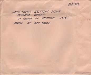
Photograph - HANRO COLLECTION: PHOTOGRAPHS OF THE ERECTION OF JOHN BROWN KNITTING MILLS, 1954
John Brown Industries became a listed company in 1951 and acquired Star Hosiery Mills factory and its Bendigo offshoot. In 1955 they purchased a 4 acre site at Ironbark to build a new mill. This was completed in a record 19and a half weeks and the mill was handed over in Sept. 1956.Photographs of the Erection of John Brown Knitting Mills: A brown envelope which had hand printed writing in black ink. On the right hand top is *MP385*. In the middle *John Brown Knitting Mills Ironbark Bendigo. 14 Photos of Erection 1954? Photos by Reg Brock*. Attached to the envelope is a torn piece so paper which has been hand written in blue ink *John Brown & Welmar* Knitwear Socks & Dress wear The Finest in the Land. Made on the site of Bendigo's Richest Gold Mine, *The Little 180*. Inside the envelope is a collection of black and white photos of the erection of the John Brown Knitting Mills on Marong Road in Ironbark Bendigo. 14 Photos in total showing various views of the construction site. Workmen on the site laying bricks, constructing the steel building and trucks delivering steel etc. A crane truck with *General Carriers Bendigo* printed on the side door. On the back of each photo is *MP385*. The Circular stamp in blue ink of the Royal Historical Society of Victoria Bendigo Branch and a cream photographers label with a blue band top and bottom with *Reg. V. Brock of Bendigo in the bands. In the centre of the label in blue print is *No.... B1098. pos.... Additional copies may be obtained at any time by quoting this number. Box 116A.Reg. V. Brock of Bendigo.photograph, building, john brown, john brown knitting mills -
 Bendigo Historical Society Inc.
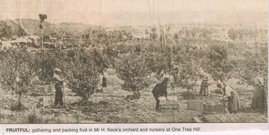
Newspaper - JENNY FOLEY COLLECTION: FRUITFUL
Mr Herbert Keck began planting his orchard c. 1886 and by 1902 had 33 acres under orchard and nursery stock. His endeavour was seen as a model orchard producing abundant crops. Herbert Keck was at one time, president of the Strathfieldsaye Shire and a MLC for Victoria. Bendigo Advertiser '' The way we were'' from 2002. Fruitful: gathering and packing fruit in Mr. H. Keck's orchard and nursery at One Tree Hill. The clip is in a folder.newspaper, bendigo advertiser, the way we were -
 Bendigo Historical Society Inc.
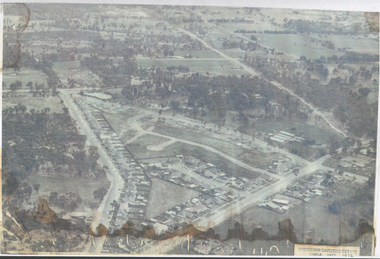
Photograph - Aerial View Sydenham Gardens Estate Circa 1972
The Sydenham gardens were set up in 1854 to provide an area of relaxation for diggers. A German, Mr Kraemer, made extensive plantings of ornamentals and fruit trees. The area expanded to 11 acres in 1865 and 25 acres in 1916. T O Hunter owned the gardens from about 1896 and initially it was used for many types of entertainment including, picnics, festivals and sporting events. It was situated off Holdsworth Road in what is now Jackass Flat. T O Hunter was a cordial manufacturer in Macrae Street, who was prominent in many sporting areas. He was President of the Bendigo Coursing Association and raced both dogs and horses. By the time he sold the gardens in 1936 to Mr Muir, he was using the gardens as grazing for his horses.Photograph: aerial view of Sydenham Gardens Estate Circa 1972 , as noted on photo Colour photo, A5 sizephoto sydenham gardens estate, aerial photo -
 Bacchus Marsh & District Historical Society
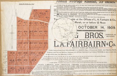
Map, Greystones Estate Land Sale 1909
This map was produced sometime around mid 1909 to advertise portions of land from the Greystones Estate for sale by public tender. The selling agents were Young Brothers of Horsham and L.A. Fairbairn of Bacchus Marsh and Melbourne. The seller was Molesworth R. Greene who was a pioneer pastoralist in the Bacchus Marsh area and had also acquired other properties in Victoria and interstate. Molesworth Greene died in 1916 so this sale came towards the end of his life. A total of 4,176 acres was offered for sale in multiple lots. Successful tenderers could buy single or multiple lots. The results of the sale were reported in the Bacchus Marsh Express newspaper on the 16th October 1909, page 3. At the sale a total of 3, 420 acres was sold. A single page paper map showing portions of land for sale from the Greystones Estate near Bacchus Marsh. The map includes extensive details about the property, number of allotments for sale, terms and conditions of the sale and prices. The map includes an inserted reference map showing the location of the property in relation to Melbourne, Geelong, Ballarat and Castlemaine. The top of the map appears to be missing resulting in some loss of the text. The sale notice in the Bacchus Marsh Express of 10 July, 1909, page 3, column 1 appears to duplicate the text overall in the auction plan. Based on this the missing text is likely to be: "Important Subdivisional Sale 'Of Portion of One of the Best and Most Favourably known Estates IN THE RENOWNED BACCHUS MARSH DISTRICT. And situated only six miles from that prosperous township, two miles from Rowsley, and three miles from Parwan, all Railway towns, connected with the Estate by metal roads." Scale: 20 chains to 1 inch The map is pasted into a bound volume containing 76 maps or plans in total. bacchus marsh victoria maps, land sales, land sales bacchus marsh, greystones estate bacchus marsh, molesworth r. green 1827-1916, land sales rowsley -
 Greensborough Historical Society
Photograph - Digital Image, Blackjack: Peter and Paul, Greensborough 1956, 1956_
Peter and Paul Robinson, 1956, at Blackjack, the home of the Robinson family to late 1956. The Blackjack property, house and acres of fruit orchards ran down to the Plenty River off Hume Street Greensborough. The photographs were taken as slides by Frank Robinson and digitised by his son James in 2015.Digital copy of colour photograph.robinson family, blackjack -
 Greensborough Historical Society
Photograph - Digital Image, Blackjack from the river flats below, 1954_
Blackjack from the river flats below. The Blackjack property, house and acres of fruit orchards ran down to the Plenty River off Hume Street Greensborough and was the home of the Robinson family to late 1956. The photographs were taken as slides by Frank Robinson and digitised by his son James in 2015.Digital copy of colour photograph.blackjack, robinson family -
 City of Moorabbin Historical Society (Operating the Box Cottage Museum)
Photographs,x3 Colour Early Weatherboard Cottage Cheltenham c1880, 1981
Henry Dendy , a farmer from Sussex England, purchased 5,120 acres of land in the area of a 'Special Survey 1841' that extended from Brighton bayside North Road, East Boundary Rd to South Road. This area became known as Dendy's Brighton and as part of the sale 139 emigrant workers arrived in 1842 however Dendy was unable to find work and lodgings for these people. J.B.Were, financier took over the management of the 'Special Survey 1841' area and began to sell and lease allotments. 1850 the Squatter King brothers sold land south of Dendy's 'Special Survey 1841' to Josiah Holloway who sectioned it into 2 acre lots @ £10 each for market gardens - 'Two Acre Village' and Charles Whorral opened a small hotel - 'The Cheltenham Inn' on the main Road - Arthur's Seat Rd, later Point Nepean Rd, now Nepean Highway. Notable settlers who moved into the area were Keys, Charman, Bruton, Le Page, Fairlam, Meeres and 1862 saw the separation from Brighton and the formation of the Mooorabbin Roads Board District. .By 1879 1000settlers were living in 'Cheltenham' serviced by a Post Office with Bank, Mechanics Institute, State School No 84,Keys Hotel, Meeres Store, Sir Thomas Bent ensured the new Railway Line from Caulfield to Mordialloc went through his constituency of Cheltenham 1881 and this changed the development to the bayside area of Cheltenham away from the 'Two Acre Village ' side causing some dissention, However Cheltenham as whole prospered and this house in Pine St is typical of the cottages built c 1890- 1900 in the area. This weatherboard house c 1890-1900 in Pine St Cheltenham is typical of those built for early settler families. Photo taken 1981 by CMHS member 3 x Colour photographs of an early c 1900 weatherboard house in Pine St Cheltenham taken by CMHS member 1981Kodak Aug. 81 / Handwritten Pine St Cheltenhamkeys robert, holloway josiah, king brothers, smith j l; smith mary ann, stanley helen, chaff cutter, horse drawn carts, toll gates brighton, motor cars 1900, steam engines, early settlers, bentleigh, parish of moorabbin, city of moorabbin, county of bourke, moorabbin roads board, shire of moorabbin, henry dendy's special survey 1841, were j.b.; bent thomas, o'shannassy john, king richard, charman stephen, highett william, ormond francis, maynard dennis, market gardeners, vineyards, orchards -
 Bendigo Historical Society Inc.
Map - CAMPBELL COLLECTION: BENDIGO AND DISTRICT MAPS, 11-4-29
Map. Huntly, Parishes of Huntly, Nerring and Neilborough. Scale 20 chains to 1 inch. Total area 4738 acres. Prepared in W.P.B. from A and C.L. Plans by W.J. Galbraith 11-4-29. Eaglehawk. IN PENCIL top right of map: Euc areas 1974 Scott & Cole Comp 5,6,7,8,9,12,13. Laurie C.Raynor 10,11,17, Part 16 South of Scotsmans Track, J.T Pierce 14,15,16 North of Scotsman Track. From Neilborough. G.Ward. A.Sloan. K.Walker at bottom of map. (number 368 in map cupboard 1)W.J.Galbraithmap, bendigo, allotments -
 Torquay and District Historical Society
Black & White photocopy, Bellbrae Cemetery Memorial Exhibition 2015
Photographs donated by Valda ConnellyGundry descententsIron Bark Station was purchased by Joseph Gundry in 1844 The property consisted of 7721 acres plus conditional rights to adjoining properties.The station housed 6000 sheep and 60 cattle . In the top left hand corner of the photograph you can see the LLAMBERIS House built by Joseph Gundry. It was thought that later the property was sold and Roderick Impey Murchison was the buyer,he later offered it for sale in 1885 and later that year A N Hassall invited tenders for lots of Liamberis.C j Cook was the listed owner in 1888 ( land of the Magpie) -
 Bendigo Historical Society Inc.
Document - LANDS OFFICE, CROWN LOTS SURVEYED AND SOLD IN THE SANDHURST DISTRICT 1857 - 1905, 1857 - 1914
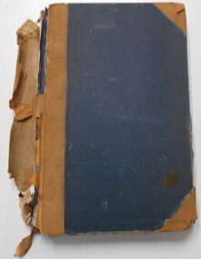
Document: blue hard cover journal with buff spine and corners. (spine in poor condition, frayed and pieces missing) Contains details of crown lands surveyed and sold in Sandhurst district. LH page: town, suburban or country lands. RH page: auction, selection, price per acre, price overall and purchaser. Indexed by parish inside front cover. On spine ' Index book' ' Lands and Survey' '07' written on spine under damaged spine cover. Dated from 26/6/1857 to 24 February 1914Lands Officeland sales, lands office, land surveyed, land sold, bendigo, sandhurst -
 Bendigo Historical Society Inc.
Document - MARKS COLLECTION: MINING LEASE BLOCKS 1873
Plan mining lease blocks 1873, timber hanger on top two brass rings, securing tape, round timber holder on bottom, scroll. On top Schedule of Mining Lease Blocks shown on the plan of the Sandhurst Gold Field, Published May 1873' Names of mining Companies listed with identifying number and area of mine site. E.g. '447 Johnson's Reef Gold Mines 7a, 2r, 8 p (acres, roods, perches). Number linked to the mine site shown on Sandhurst Gold Field map.bendigo, mining, mining lease blocks 1873 -
 Bendigo Historical Society Inc.
Document - LANDS OFFICE: REPORTS OF LAND SALES BY AUCTION 1876 - 1891, 1876 - 1891
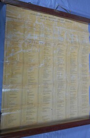
Document: green hard cover journal, buff spine and corners. Contains details of land sales by public auction Kerang, Swan Hill and Boort. m LH page ' Lot, County, Town or parish, section, allotment, sold, unsold, why not sold, upset price, sold per acre. RH page: value of improvements, name of purchaser, residence, deposit forfeited, total amount. On spine in gold lettering ' report of sales by auction' underneath 'land sales' in black. No. 6 on top of spine, letter K on base.Lands Officeland sales, kerang, swan hill, boort, sandhurst, lands office -
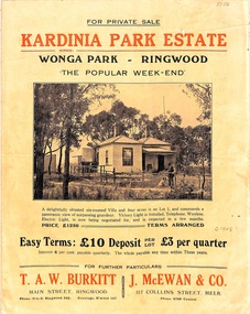 Ringwood and District Historical Society
Flyer, Land Sale Brochure, Kardinia Park Estate, North Ringwood, Vic. - circa 1948
Folded buff-coloured land sale advertisement for Kardinia Park Estate in Warranwood area of North Ringwood, including terms of sale, area map, layout plan of the estate, and summary of local facilities and services. Front page features photograph of a man and dog in front of a house captioned as Lot 1 on four acres shown on the estate layout as cnr of Brysons Road and Range View Parade (later Omeo Parade). Second page includes bushland swimming pool photograph and promotional information for prospective buyers.Subdivision includes Kardinia Crescent, Wonga Road, Brysons Road, Range View Parade (later Omeo Parade), Motor Coach Road (later Wonga Park Road, then Warranwood Road). (Agent/s) T.A.W. Burkitt, Main Street, Ringwood, Phone (9 to 6) Ringwood 242, Evenings, Ringwood 157, and J. McEwan & Co, 317 Collins Street, Melbourne, Phone 6750 Central. -
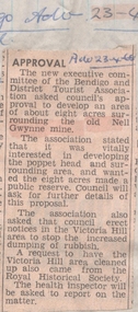 Bendigo Historical Society Inc.
Newspaper - VICTORIA HILL - APPROVAL TO DEVELOP VICTORIA HILL
Newspaper article from the Bendigo Advertiser dated 23.4 .68. The Bendigo and District Tourist Association asked council's approval to develop an area of about eight acres surrounding the old Nell Gwynne Mine. They also asked that notices be put up to stop people dumping rubbish. The Royal Historical Society also requested that the Victoria Hill area be cleaned up. Article is glued to a piece of writing paper. It has Cent. Nell, Vict. Hill and New Chum written in blue pen along the side.newspaper, bendigo advertiser, victoria hill, approval to develop victoria hill, bendigo and district tourist association, nell gwynne mine, royal historical society, new chum -
 City of Moorabbin Historical Society (Operating the Box Cottage Museum)
Document, laminated photocopy of 'Plan of Moorabbin 1850', 1853
Weston Bate, 'A history of Brighton' 1962 informs us that in 1840 Henry Dendy, who was a farmer in Sussex England, paid 5,120 pounds sterling @ 1pound per acre for a 'Special Survey of Land in Port Phillip , Australia. Henry arrived in Australia in 1841 on the frigate 'York' with his wife, son, and three servants. He also took advantage of the Government Assistance of Free Immigrants for Survey Purchasers, to help on his estate and persuaded some Sussex men with their families to follow him. However when Dendy arrived in Port Phillip he found that LaTrobe and Gipps were trying to raise the price of land close to Town to 15pounds per acre. Dendy asked merchant J.B.Were to manage his affairs and they went ahead with plans to subdivide the surveyed land called 'The Brighton Estate' This area of land extended easterly from the Port Phillip Bay to East Boundary Road and from North Road to South Road in the Parish of Bourke Victoria. The Privy Council, England , decide that Henry Dendy could purchase the land at 1pound per acre. Land Sales proceeded from 1844 as more immigrants established market gardens, farms and varied businesses in 'Moorabbin'This is a photocopy of a Map of the Moorabbin , County of Bourke c1850 showing the 'Henry Dendy Special Survey 1841'A photocopy of a Map of the Moorabbin , County of Bourke c1850. A3 size laminatedLeft corner : MOORABBIN / COUNTY OF / BOURKEdendy henry, dendy special survey 1841, brighton, moorabbin, ormond, bentleigh, market gardeners, pioneers early settlers, box william, box elizabeth -
 Greensborough Historical Society
Photograph - Digital Image, Blackjack: Greensborough flats and house on the Plenty River, 1953_
Greensborough flats and house on the Plenty River at Blackjack, the home of the Robinson family to late 1956. The Blackjack property, house and acres of fruit orchards ran down to the Plenty River off Hume Street Greensborough. The photographs were taken as slides by Frank Robinson and digitised by his son James in 2015.Digital copy of colour photograph.blackjack, robinson family, plenty river -
 Greensborough Historical Society
Photograph - Digital image, Frank Robinson, Looking north from the top orchard of Blackjack, 1954_
Looking north from the top orchard of Blackjack. The Blackjack property, house and acres of fruit orchards ran down to the Plenty River off Hume Street Greensborough and was the home of the Robinson family to late 1956. The photographs were taken as slides by Frank Robinson and digitised by his son James in 2015.Digital copy of colour photograph.blackjack, robinson family -
 Wodonga & District Historical Society Inc
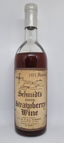
Functional object - Bottle - Schmidt's Strawberry Wine 1976
Schmidt’s Strawberry Farm is set on acres of lush strawberry fields in Allans Flat, approximately 5 kilometres from Yackandandah and 24 kilometres from Wodonga. Schmidt's is the oldest strawberry winery in Australia, owned and operated by brothers Martin and Michael Schmidt who are third generation strawberry growers/winemakers.This item originates from the oldest strawberry winery in AustraliaA bottle of Schmidt's Strawberry Wine from their 1975 harvest. The bottle bears a beige label with brown text. Their is also a sticker on the back of the bottle containing information about the wine.Front Label below a district map: 1975 Harvest/ Schmidt's /(GENUINE)/ Strawberry/ Wine/ Grown & Bottled by / J.F., D. F. & G. SCHMIDT/ ALLANS FLAT, VICTORIA/ PRODUCT OF AUSTRALIA/ .740 LITRES" On sticker across back: "Fermented from fresh strawberries with no artificial flavour or/ preservatives. This strawberry wine has been the house specialty/ of the Schmidt family for many generations - with the advent of/ improved growing techniques, this dessert wine is now introduced/ to the wine lovers of Australia."strawberry wine, schmidt’s strawberry farm, martin and michael schmidt -
 Lakes Entrance Historical Society
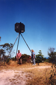
Photograph - Lakes Entrance Grid location, 1999
Lakes Entrance Grid reference, Cunninghame 8522.3.4 896.082, on ten acre site with trig point, it is from this point that all the survey for the surrounding areas was undertaken. Part of the Vic Geodetic Survey initiated in 1860 by Ellery Survey started from triangulation base in Werribee. (Grid ref B'dale 8422)Colour photograph of the Victoria Geodetic Survey Triangulation Station, Trig Station, situated off Ocean View Parade, Merrangbaur Hill. Location is indicated by ground point and standing structure, situated on an elevated bush block. Lakes Entrance Victoriasurveying, township planning