Showing 762 items
matching aerial views
-
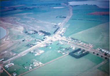 Lake Bolac & District Historical Society
Colour photograph
... Aerial view of Lake Bolac township, looking towards... Highway Lake Bolac grampians Colour photograph Aerial view of Lake ...Aerial view of Lake Bolac township, looking towards the north-east, taken circa 1968. The freshwater lake is top-right, the salt-lake is centre-left. The Presbyterian church, bottom right, is surrounded by Cyprus trees on the Woorndoo/Mortlake road. The hotel and general store are opposite each other on the crossroads of the Mortlake/Ararat and Ballarat/Hamilton roads and the sporting complex is behind the store next to the salt lake. The Primary School, No 854, is between the footy oval and the Ararat Road, centre left.lake bolac, freshwater lake, salt lake, presbyterian church, hotel, general store, sporting complex, primary school, no 854. -
 Federation University Historical Collection
Photograph - Photograph - Black and White, N.L. Harvey & Sons Photographers, Ballarat School of Mines Aerial View
... Ballarat School of Mines Aerial View...Aerial view of the Ballarat School of Mines campus from... Aerial View Aerial view of the Ballarat School of Mines campus ...The Ballarat School of Mines Campus is a campus of Federation University Australia.Aerial view of the Ballarat School of Mines campus from the Grant Stret/Eyre Street corner. The photograph was taken after the demolition of the gaol and before the E.J. Tippett Library and Hillman Recreation Reserve were built. The Ballarat Girls' Technical School is present in Grant Street, and in sthe Ballarat SChool of Mines Mining Laboratory in Albert Street. The Ballarat Brewery (then Carton and United Breweries) is present in Lydiard Street South.aerial, ballarat school of mines, ballarat gaol, ballarat school of mines tennis court, grant street, ballarat girls' junior technical school -
Port Melbourne Historical & Preservation Society
Photograph - Aerial view of J Kitchen & Sons site, Port Melbourne, C D Pratt Airview, 21 Mar 1939
... Aerial view of J Kitchen & Sons site, Port Melbourne... Kitchen & Sons Pty Ltd. On back "Aerial view looking North East... Street) Port Melbourne melbourne Aerial view of J Kitchen & Sons ...COPYRIGHT C D PRATT Black and white photograph of J Kitchen & Sons Pty Ltd. On back "Aerial view looking North East, 21st March 1939". Signs on three middle buildings 'J Kitchen & Sons Pty Ltd'; 'Pure Velvet Soap'; 'Electrine Candles'. Sign 'Australian Box Mills' on building to left "E L Pinkus' on building to Nort east and behind it 'Petersen & La...'"This photo is copyright" and information on owner - C D Pratt 86 McCracken St, Essendonindustry - manufacturing, j kitchen & sons pty ltd, australian box mills, e l pinkus, petersen -
 Lakes Entrance Regional Historical Society (operating as Lakes Entrance History Centre & Museum)
Postcard, Bulmer H D, 1922c
... Black and white photographic postcard, showing early aerial... photographic postcard, showing early aerial view of township of Lakes ...Black and white photographic postcard, showing early aerial view of township of Lakes Entrance, Cunninghame Arm, North Arm and sand dunes, ocean in lower foreground, Eastern wharf and various boats on lake. Princes Highway went along Esplanade, Myer Street and Roadknight Street, very little vegetation on sand dunes, no foot bridge yet, good view of North Arm, few houses. Lakes Entrance VictoriaLakes Entrance and Backwater from the Air.islands, aerial photograph, waterways, topography, township -
 Bendigo Historical Society Inc.
Photograph - PETHARD COLLECTION: PROMOTE VICTORIA MISSION
... Victoria mission / photos include aerial view of Boston, Heinz... and white photos of Promote Victoria mission / photos include aerial ...GEORGE PETHARD COLLECTION INCLUDING REFERENCES TO TARAXALE BREWING COMPANTY PTY LTD 6 x black and white photos of Promote Victoria mission / photos include aerial view of Boston, Heinz factory, 1957 Universal Pictures Company including American actress Lana Turner from the film The Lady Takes a Flyer / photos are inside a yellow paper brochure with a Boston seal on the front showing the history of Boston.photograph, person, george a pethard, george pethard / taraxale brewing company pty ltd / heinz factory / universal pictures company including american actress lana turne / -
 Orbost & District Historical Society
black and white photograph, February 1971
... This photograph is an aerial view of the township of Orbost... is an aerial view of the township of Orbost taken by the Bairnsdale ...This photograph is an aerial view of the township of Orbost taken by the Bairnsdale Advertiser newspaper. It was taken from the northern end of the town. The 1971 flood was the the worst flood on record. At Jarrahmond it was at least 11 metres and up to one and a half kilometres wide on the flats causing enormous damage to the flood plain. Records say that "The brown floodwater stain in Bass Strait could be seen from passing airliners." Considerable damage was done to railway infrastructure, roads and farms. More information from the APRIL, 2008 newsletter by John Phillips. (see orbosthistory.com.au)This is a pictorial record of a significant event in the history of Orbost,A black / white aerial photograph of a township with floodwaters in the background.on back - "Note main current through the lagoon 1971."orbost-floods-1971 bairnsdale-advertiser orbost-township -
 Nillumbik Shire Council
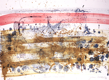
Print (Lithograph): John Olsen (b.1928 NSW), John Olsen, Tropical Rain Shower from The Bodford Terrace Suite, 1978
... A typical Olsen painting combines an implied aerial view... combines an implied aerial view with an ambiguous and seemingly ...A typical Olsen painting combines an implied aerial view with an ambiguous and seemingly unpremeditated figuration. His characteristically quizzical line and irregular squiggles and dots deftly render countless organisms, large and minute. Their environment is conjured through loosely brushed and stained expanses of colour (on canvas or hardboard) and lines which sometimes read as geological mappings. In Olsen's work there is no foreground/ middle ground/ background, nor any sign of European landscape's concern with "human scale." Instead he employs simultaneously the contrary vantages of naturalist and geographer. 'Tropical Rain Shower' by John Olsen forms one of the eight artworks represented in the Bodford Terrace Suite. Eight of Australia's finest artists were brought together to create a folio of lithographic prints to celebrate the restoration of historic Bodford Terrace. Printed at the Druckma Press by John Robinson under the supervision of master printer Jock Abbott. The folio edition was limited to 300 signed and numbered folios. The lithographs were printed on special heavy weight french Arche's paper in accordance with the tradition of this artistic medium. Lithographic print on paper.Signed John Olsen '78, lower right hand corner. Edition 179/300bodfford terrace collection, john olsen, tropical rain shower -
 Federation University Historical Collection
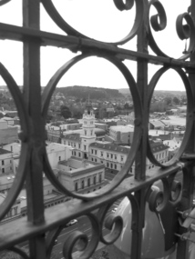
Photograph, Lisa Gervasoni, Ballarat Post Office from Town Hall Tower, 2007
... Aerial view of the Ballarat Post Office, corner of Sturt.... Aerial view of the Ballarat Post Office, corner of Sturt Street ...Aerial view of the Ballarat Post Office, corner of Sturt Street and Lydiard Street North, taken from the tower of the Ballarat Town Hall, corner of Sturt Street and Armstrong Street South. The Post Office was opened in December 1858. Photograph taken through the wrought iron of the tower in 2007. The tower and main entrance to the Post Office face Lydiard Street North. Other buildings from the same era are the former Bank of Australia, opposite corner, and the Mining Exchange. In the distance is Black Hill, an old mining area.Black and white photograph of the Ballarat Post Office on the corner of Sturt Street and Lydiard Street North, taken from the tower of the Ballarat Town Hall corner of Sturt Street and Armstrong Street South. View is taken through the wrought iron of the tower. post office, town hall, tower, wrought iron, sturt street, lydiard street, armstrong street, bank of australia, mining exchange, black hill -
 Rutherglen Historical Society
Photograph - Aerial Images, c2000
... Colour aerial photograph of Rutherglen, viewed from...-country Aerial Images Photograph Colour aerial photograph ...Colour aerial photograph of Rutherglen, viewed from the North East.Written on back of photo: "Water tower (mid) Silos left"rutherglen, rutherglen winebottle, water tower -
 Rutherglen Historical Society
Photograph - Aerial Images, c2000
... Colour aerial photograph of Rutherglen, viewed from...-country Aerial Images Photograph Colour aerial photograph ...Colour aerial photograph of Rutherglen, viewed from the South West.Written on back of photo: "St Stevens lower left corner, State School just above | & Glenview, Silos mid left"rutherglen, st stephens church, saint stephens church, rutherglen winebottle, glenview nursing home, rutherglen state school -
Tatura Irrigation & Wartime Camps Museum
Photograph, Luise Katz, 1942-1946
... Colour photograph of drawing of Camp 3 aerial (more or less... 3 aerial (more or less) view. Artifacts made in Camp 3. camp ...Artifacts made in Camp 3.Colour photograph of drawing of Camp 3 aerial (more or less) view.camp 3, hand made objects, camp 3 hand crafts, templer society -
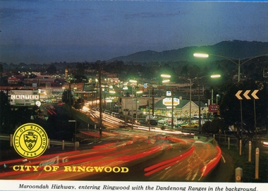 Ringwood and District Historical Society
Postcards, Colorscans (Publishing) Pty Ltd, Various postcards of Ringwood in the 1970s, c. 1968
... in the background (3303_001.jpg); 2. Aerial View of the City of Ringwood... in the background (3303_001.jpg); 2. Aerial View of the City of Ringwood ...Postcards - pack of 6: 'Ringwood Victoria - tear off postcard folder - 6 views' (two identical folders); 1. Maroondah Highway, entering Ringwood with the Dandenong Ranges in the background (3303_001.jpg); 2. Aerial View of the City of Ringwood (3303_002.jpg); 3. Eastland Regional Shopping Centre at dusk (3303_003.jpg); 4. The Ringwood Memorial Clock Tower (3303_004.jpg); 5. The Civic Centre (3303_005.jpg); 6. The Ringwood Lake (3303_006.jpg) -
City of Kingston
Photograph - Black and white, 5 January 1984
... aerial view includes Eden Street and Edward Street, Cheltenham... Aerial photograph of Cheltenham, Beaumaris, Moorabbin and Highett ...Moorabbin, Cheltenham and Highett are suburbs in the City of Kingston with a diverse mix of development and zoning. The market gardens, farms and paddocks have gradually been sub-divided into housing and industrial estates and associated infrastructure such as schools and shopping facilities. The area includes many parks, reserves and golf courses.This aerial image covers a diverse section of the City of Kingston, taking in the suburbs of Cheltenham, Moorabbin, Beaumaris and Highett. By 1984, the market gardens of the district have been replaced by housing and factories. The Gas and Fuel state-of-the-art Scientific Services Department is visible on Nepean Highway Highett. The CSIRO Highett site can also be seen. Both sites have now been demolished and have undergone remediation. The Southland site is visible and yet to be redeveloped by Westfield. This image portrays the diversity of development in the City of Kingston with a mixture of green spaces, housing and commercial and industrial features.Aerial photograph of Cheltenham, Beaumaris, Moorabbin and Highett within the City of Kingston. The area depicted in the 1984 aerial view includes Eden Street and Edward Street, Cheltenham (top left), Weatherall Road and Reserve Road, Cheltenham/Beaumaris (top right), Turner Road and Chesterville Road, Moorabbin (bottom left), Nepean Highway (left section), Graham Road and Middleton Street, Highett (bottom right). A large section of this image includes Cheltenham Park and Victoria Golf Club.White text: 3831-219 Lens information [indecipherable] RINGWOOD M/S 7922-3 RUN 15 Clockface image 5,300' ASL VIC DLS© 5-1-84cheltenham, highett, industrialisation, urbanisation, moorabbin, beaumaris -
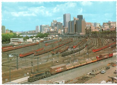 Melbourne Tram Museum
Postcard - Flinders St Rail Yard and city, Biscay Greetings, mid 1970s
... Shows an aerial view looking west over the Flinders St... Shows an aerial view looking west over the Flinders St railway ...Shows an aerial view looking west over the Flinders St railway yards and the city skyline. Photo shows the Swimming centre in Batman Ave, the Victorian Railways Metrol signal control building and the large yard with Tait, Harris and a silver train. On the left is the overhead wiring train A goods train lead by a flat top T class is passing in the lower part of the photo. In the 1980s the yards were redeveloped to provide the Tennis Centre, partly roofed at the western end and a new bridge over the yard at Exhibition St that replaced the tram track in Batman Ave and the Princes Bridge terminus.Yields information about the Flinders Railway Yard prior to redevelopment.Postcard - Flinders St Rail Yard and city - Serrated edges - Divided back BG83railways, victorian railways, railway yard, flinders st, suburban trains, melbourne -
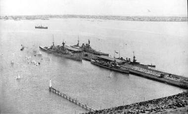 Port Melbourne Historical & Preservation Society
Photograph - Aerial view of HMS Hood (outer east), HMS Repulse (outer west) with escorts Delhi and Danae, Princes Pier, Port Melbourne, Mar 1924
... Aerial view of HMS Hood (outer east), HMS Repulse (outer...(1) Aerial photographic view of Princes Pier with units... Street) Port Melbourne melbourne Aerial view of HMS Hood (outer ...(1) Aerial photographic view of Princes Pier with units of the British Navy alongside 17-25 March 1924. principal vessels are the HMS Hood (OE) and HMS Repulse (OW) with escorts Delhi and Danaepiers and wharves - princes pier, armed services - navy, vessels, hms hood, hms repulse, hms delhi, hms danae -
 Federation University Historical Collection
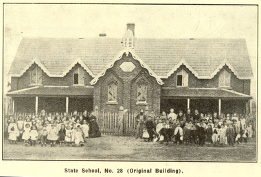
Booklet, Back to Bacchus Marsh, 1930
... , 1930 * Aerial View of Bacchus Marsh Township looking east... * Bacchus Marsh Looking West, 1930 * Aerial View of Bacchus Marsh ...The 1930 Back to Bacchus Marsh celebrations were held on 23 to 28 October 1930. The committee were Cr L.M. Gugdale (president), A.W. Bond (General secretary), W. Grant Morton, J.G. Wells, Dr E. McDonald, Charles Dickie, G.H. Anderson, F.M. Crisp, W.R. Vigor. Bacchus Marsh State School No. 28 was established in 1851 as a National School in a rented building on the right-hand side of Bacchus Marsh-Melbourne Road, just beyond Woolpack Inn. Several willow trees mark the site. H.G. Ball was the first Head Teacher of the school, and the enrolmen towas 34. In 1854 Governor Charles Hotham visited the school. In 1855 two new schools, East and West, were recommended. School No. 28 closed in 1862 and the sitre was sold. The present school site was purchased in 1865 for 67 pounds. The cost of the building was 782 pounds. (Visions and Realisations, Vol 3., 1973) A clock purchased by public subscription was placed in the front of the building to the memory of scholars who served during World War One. (Back to Bacchus Marsh, 1930)Brown covered book of 44 pages. Contents include Bacchus Marsh and its soldiers, Red Cross, Lerderderg Gorge, Werribee Gorge, Lerderderg Park, Coimadai, Darely Firebrick Co., Myrniong, Underbank, Balliang, Rowsley, Parwan, schoosl, churches, Shire Council, Federal Milk Pty Ltd, Bacchus Marsh Milk, Old Maddingley Bridge Images include: * Bacchus Marsh looking east, 1930 * Bacchus Marsh Looking West, 1872 * Bacchus Marsh Looking West, 1930 * Aerial View of Bacchus Marsh Township looking east * Aerial View of Bacchus Marsh Township looking south * Bacchus Marsh Agricultural Society & Pastoral Society, 1893 (named), * Original Bacchus Marsh State School No 28 * Holy Trinity Bacchus Marsh * Bacchus Marsh Baptist Church * St Bernard's Catholic Church * Bacchus Marsh Methodist Church * St Andrew's Presbyterian Church Bacchus Marsh * View of Maddingley Park, showing Original Courthouse, 1890 * Werribee Gorge * Underbank Stud Farm * Ballarat State School Number 28. Signed 'C. Hodgson'bacchus marsh, maddingley, maddingley park, underbank, lerderderg park, coimadai, darely firebrick co., myrniong, balliang, rowsley, parwan, schoosl, churches, shire council, federal milk pty ltd, bacchus marsh milk, old maddingley bridge, police, police paddock, maddingley gates, crisp, mccormack, cain, harkness, howe, bence, mcdonald, mcfarlane, cosgrave, flagg, burnip, scott, lodge, cameron, vallance, bacchus marsh state school, bacchus marsh state school no 28., geology, r.w. thompson, lederderg gorge, weribee gorge, comadai, darley firebrick company -
 The Beechworth Burke Museum
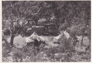
Photograph, 1944
... Taken in 1944, depicted is an aerial view of an Australian... is an aerial view of an Australian military camp set up at Mt. Stanley ...Taken in 1944, depicted is an aerial view of an Australian military camp set up at Mt. Stanley in Victoria. There are two large tents along with a vehicle and trailer surrounded by bushland. A secret experimental micro-wave radio station was established and tested at this site by the Army Signal Detachment Unit during World War II. It was part of an experimental Ultra High Frequency (UHF) link between Melbourne and Sydney. At the time, it was highly classified. It intended to enquire into the hitherto unexplored transmission of micro-waves; that is, a radio signal which could only be transmitted by line of sight, and thus required hill-top to hill-top location.The photograph is historically significant as it pertains to World War II; the largest global conflict in history. This significance is enhanced by Australia's prominent involvement in campaigns across the Pacific, particularly on land in New Guinea and across the Huon Peninsula. It was also the first time that the Australian mainland came under direct attack by the Axis, with Japanese forces targeting north-west Australia and Sydney Harbour. These battles became Australia's largest and most complex offensives during the war. The record is also historically significant as it relates to the Royal Australian Corps of Signals, or "RA Sigs". This significance is strengthened by Australia's unique distinction of having the first established signal unit under the British Empire. This unit provides electronic warfare. They enable commanders to implement highly dynamic battle control against opposing forces by using a number of methods including radio, fibre optic, micro-wave, information systems and satellite links. The record has strong research potential. This is due to the ongoing scholarly and public interest in war, military history, the ANZAC legend, and the continuing existence of the RA Sigs. The historic context of this record can provide insight into Australia's history, military, technological innovation and advancements, as well as national economic, defence and foreign policies after 1945.Black and white rectangular photograph printed on matte photographic paper.Reverse: BMM5095.11 / Our camp / From the top. / (?) (?) /military album, army album, australian royal corps of signals, army signal detachment unit, mt. stanley, victoria, beechworth, wwii, world war ii, melbourne, sydney -
 Lake Bolac & District Historical Society
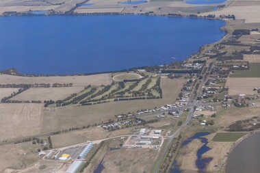
Colour photograph, Aerial view of Lake Bolac and village. After the rain, 2010
... Aerial view of Lake Bolac and village. After the rain...Aerial view of Lake Bolac after the drought had broken... Highway Lake Bolac grampians Colour photograph Aerial view of Lake ...Aerial view of Lake Bolac after the drought had broken in late 2010. The fresh-water lake is now full, as are the wetlands. Note the edge of the salt-lake in the bottom right, the Industrial Estate bottom left and centre, the golf course, the current footy oval, Bowling Club, tennis courts and swimming pool with the P-12 College through the trees on the bank of the lake. An Archaeologist might be able to discern the original footy oval bottom centre, built on what was once the town Common (below the industrial buildings),and the second oval (above the salt lake.) The houses are spreading along the west bank of the lake beyond the school.lake bolac, 2010, village, fresh-water lake, salt lake, golf, tennis, bowling, swimming, college, -
City of Kingston
Photograph - Black and white, 17 January 1951
... aerial view includes Wickham Road, Highett (bottom right), Keys.... The area depicted in this 1951 aerial view includes Wickham Road ...Moorabbin, Cheltenham and Highett are suburbs in the City of Kingston with a diverse mix of development and zoning. This 1954 image shows the market gardens, farms and paddocks of the Moorabbin and Cheltenham area. which have gradually been sub-divided into The Highett Gas Works is visible and Cheltenham Park and Victoria Golf Club.The suburbs of Cheltenham and Moorabbin were originally developed with extensive market gardens. Over time the district has been transformed with the farms and paddocks replaced by housing, factories and shopping centres. The Highett Gas Works on the Nepean Highway was a significant feature of the landscape and has now been demolished. and the site has undergone remediation.Aerial photograph of Cheltenham, Moorabbin and Highett within the City of Kingston. The area depicted in this 1951 aerial view includes Wickham Road, Highett (bottom right), Keys Road, Moorabbin (bottom left), Centre Dandenong Road Cheltenham (top left), Park Road, Cheltenham (top right), Nepean Highway (left section), Graham Road and Middleton Street, Highett (bottom right). Cheltenham Park and Victoria Golf Club are visible. Nepean Highway and the Frankston railway line run centrally through the image.White type: 1416-37 538 RUN239 LENS 5312" MELBOURNE METROPOLITAN 12150 17-1-51 ↆ M539 Black pencil: N [arrow]cheltenham, highett, highett gas works, market gardens -
 Port Melbourne Historical & Preservation Society
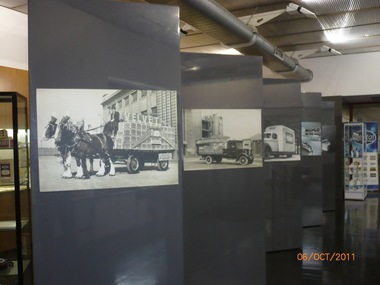
Photograph - Pental/Symex Museum, Woodruff Street, Port Melbourne, Oct 2011
... ) a framed aerial photographic view of the site (.03) Ledgers... boards within the museum (.02) a framed aerial photographic view ...The pictures were taken in October 2011 by PMHPS members and in February 2013 the contents of the museum were given to PMHPS for safekeeping prior to the closure of the site.Pictures taken inside the Pental/Symex museum in Woodruff St building. Displaying historical items and photos of interest in relation to the activities of J Kitchen & Sons on this site. (.01) some of the display boards within the museum (.02) a framed aerial photographic view of the site (.03) Ledgers, photographs, trophies (.04) bench with books, photos, candlesticks (.05) framed aerial view of the site plus other photos and ledgers (.06) full wall and bench of display (.07) Horse drwan cart of Velvet soap - one of the display boards mentioned in .01 (.08) Open truck loaded with Velvet soap - one of the display boards mentioned in .01 (.09) Framed photo of Candle Room - one of the display boards mentioned in .01 (.10) Velvet Soap truck, enclsed van - one of the display boards mentioned in .01built environment - industrial, business and traders - soaps/candles, j kitchen & sons pty ltd, pental products pty ltd, symex holdings ltd -
 Melbourne Legacy
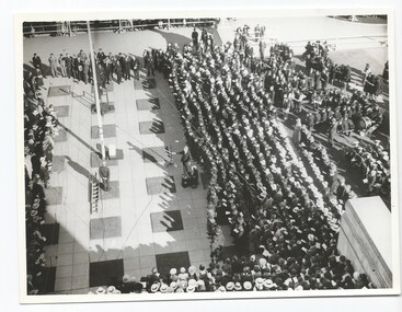
Photograph - Photo, Anzac commemoration for students, 194?
... are similar to the 1945 photos. The photos are an aerial view... are similar to the 1945 photos. The photos are an aerial view ...A Legacy ceremony at the Shrine of Remembrance. One of the annual "Anzac Commemoration Ceremony for Students" events, usually held just prior to ANZAC Day. The ceremony provides a valuable opportunity for students to gain an appreciation of the Anzac spirit, the significance of the Shrine and the meaning of Anzac Day. The year is unknown but barricades and flagpole are similar to the 1945 photos. The photos are an aerial view of the crowd and the flagpole, with the Australian flag at half mast, as viewed from the Shrine balcony. Items were in an envelope with other photos and programmes from different School Student ceremonies. Labelled S15 in red pen it was part of an old archive numbering system, that showed there has been efforts in the past to collect, order and save items of Legacy's history.A record of a ceremony for school students at the Shrine.Black and white photo x 2 of an Anzac Commemoration Ceremony for students at the Shrine.Stamped with purple copyright stamp of The Age and The Leader. anzac commemoration for students, wreath laying ceremony -
City of Kingston
Photograph - Black and white, 3 March 1954
... aerial view includes Warrigal Road and Centre Dandenong Road.... The area depicted in this 1954 aerial view includes Warrigal Road ...Cheltenham and Moorabbin are suburbs within the City of Kingston that were originally established as rural market gardening communities The area is bordered by Highett and Mentone. The market gardens, farms and paddocks have gradually been sub-divided into housing and industrial estates. Highett is developed with residential homes but was also the site of major facilities such as the Highett Gas Works. This aerial image covers a diverse section of the City of Kingston, taking in the suburbs of Moorabbin, Cheltenham, Highett and Mentone Residential housing development is prominent along the Frankston Railway line and the area still retains extensive market gardens and paddocks yet to be converted to a large industrial and commercial zone.Aerial photograph of Mentone, Cheltenham and Moorabbin within the City of Kingston. The area depicted in this 1954 aerial view includes Warrigal Road and Centre Dandenong Road intersection (top left); Charman Road, Patty Street, Bourke Street, Collins Street Mentone (top right); Keys Road Moorabbin (bottom left); Bay Road, Cheltenham (bottom right), Friendship Square, Cheltenham Park, Victoria Golf Club and Jack Barker Oval are visible. Nepean Highway and the Frankston railway line run centrally through the image. Highett Gasworks is also evident.White handwriting and type [indecipherable]. White image of clockface White image of compass White type 42956 Black handwriting 3/3/54 Williams [indecipherable] Black pencil: S [arrow] Black ink: 3/3/1954cheltenham, moorabbin, mentone, highett, market gardens -
Moorabbin Air Museum
Document (item) - Various aircraft photos and drawings see description, CAC Misc documents and design drawings of various aircraft
... aerial view 1946, Hornet, Macchi, Mustang, Winjeel, Wamira, Sabre... Bend aerial view 1946, Hornet, Macchi, Mustang, Winjeel, Wamira ...xyz -
Lakes Entrance Regional Historical Society (operating as Lakes Entrance History Centre & Museum)
Photograph, Gippsland Ports, 2006 c
... Colour aerial photograph showing view of entrance... The Entrance Waterways Colour aerial photograph showing view ...Colour aerial photograph showing view of entrance to Gippsland Lakes from Bass Strait Reeves Channel Rigby Island and township of Lakes Entrance Victoriaaerial photograph, historic site, dredging, the entrance, waterways -
Port Melbourne Historical & Preservation Society
Photograph - Aerial view of the mouth of the Yarra from Williamstown, 2006
... Aerial view of the mouth of the Yarra from Williamstown...B&W aerial photographic view of the mouth of the Yarra... Street) Port Melbourne melbourne Aerial view of the mouth ...B&W aerial photographic view of the mouth of the Yarra River, taken from above Williamstown and looking east. Greenwich Bay and the cooling water outlet for Newport Power Station in the foreground, the entrance and Webb Dock in the centre, Sandridge Beach and the city upper right.piers and wharves - webb dock, yarra river, garden city, fishermans bend, newport power station -
 Phillip Island and District Historical Society Inc.
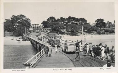
Photograph - Post Cards, A. J. Murray et al, c 1940
... ". Photo 02. Aerial view of "Broadwater" Cowes, Phillip Island.... "Photo Shop Series". "Cowes from the Jetty". Photo 02. Aerial ...A collection of 6 postcards and 1 photograph taken around Phillip Island. Donated by Julie Barnett.Photograph 228-01. Black & White photograph of the Cowes Pier with vehicles and pedestrians. Rail tracks on pier. Isle of Wight Hotel in background. Sheds at end. Photograph 228-02. Black & White aerial photograph of "Broadwater" Guesthouse, Cowes. Photograph 228-03. Black & White photograph of Cowes Pier with Steamer coming in. Shed at end of Jetty and Cenotaph in the foreground. Looking north. Photograph 228-04. Black & White photograph of a Koala and her young. Photograph 228-05. Black & White photograph looking over the Cowes shoreline near Lover's Walk. Photograph 228-06. Black & White photograph of a group of penguins coming home at dusk at the "Penguin Parade". Photograph 228-07. Black & White photograph of Bert West holding a Shearwater (Mutton Bird) with it's wings outstretched.Photo 01. "Photo Shop Series". "Cowes from the Jetty". Photo 02. Aerial view of "Broadwater" Cowes, Phillip Island. No. 146 Photo 03. "Photo Shop Series". The Jetty. Cowes. Photo 04. "Photo Shop Series". "Koala Bear". Phillip Island Photo 05. "The Rose Series P3416". "Near the Lovers' Walk, Cowes, Phillip Is., Vic. Photo 06. "Penguins, Phillip Island." No. 82. Valentines Series. Photo 07. On Back: Mr West with Mutton bird at Phillip Island.wildlife - koalas, wildlife - penguins, penguin parade, bert west, wildlife - mutton birds, mutton birds, shearwaters, cowes pier phillip island, cowes jetty, lover's walk cowes, broadwater guesthouse cowes phillip island, guesthouses cowes phillip island, julie barnett -
 Melbourne Legacy
Photograph - Photo, Anzac commemoration for students
... sitting on the forecourt. 01195.4 and 01195.5 are aerial views... sitting on the forecourt. 01195.4 and 01195.5 are aerial views ...A Legacy ceremony at the Shrine of Remembrance. One of the annual "Anzac Commemoration Ceremony for Students" events, usually held just prior to ANZAC Day. The ceremony provides a valuable opportunity for students to gain an appreciation of the Anzac spirit, the significance of the Shrine and the meaning of Anzac Day. The year is unknown but barricades and flagpole are similar to the 1945 photos. 01195.1 shows school children playing bugles. 01195.2 and 01195.3 show school girls with floral wreaths sitting on the forecourt. 01195.4 and 01195.5 are aerial views of the crowd and the flagpole, with the Australian flag at half mast, as viewed from the Shrine balcony. Items were in an envelope with other photos and programmes from different School Student ceremonies. Labelled S15 in red pen it was part of an old archive numbering system, that showed there has been efforts in the past to collect, order and save items of Legacy's history.A record of a ceremony for school students at the Shrine.Black and white photo x 5 of an Anzac Commemoration Ceremony for students at the Shrine.Photos are stamped with purple copyright stamp of The Argus with identifying numbers, (M2351, M2469-C, M2469-D, M2469-A) in pencil. anzac commemoration for students, wreath laying ceremony -
 Melbourne Legacy
Photograph, Holmbush excursion, 194X
... holiday. Aerial view is a poor photocopy added for reference. From... holiday. Aerial view is a poor photocopy added for reference. From ...Photo of an excursion to what is believed to be Blamey House in Beaumaris possibly in the 1940s or 1950s. The Beaumaris property had a swimming pool which looked very similar. It could be when junior legatees from the country came and stayed at Stanhope, Harelands and Blamey House for a summer holiday, while city children were escorted out to regional areas for a country holiday. Aerial view is a poor photocopy added for reference. From a photo album which contains photos of Holmbush and some of the excursions and events that happened there, appears to have been put together in the 1940s. Including trips to the zoo and picnics. Holmbush was one of the Legacy residences that housed junior legatees from 1942. When Blamey House in Beaumaris was sold in 1956 the name was transferred to Holmbush at 1267 Burke Road from 1957 until it was sold in 1977.A compilation of photos of the junior legatees in the Legacy residences.Black and white photo children of Holmbush at a swimming pool pasted to the page of an album.residences, holmbush, pool, blamey house -
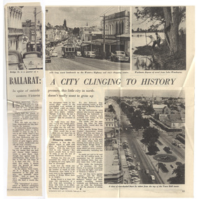 Ballarat Tramway Museum
Magazine, Woman's Day, "Ballarat a City Clinging to History", 8/02/1960 12:00:00 AM
... , an aerial view looking west from the Town Hall down and workmen..., an aerial view looking west from the Town Hall down and workmen ...Yields information about the viewpoint of The Courier about the future of the Ballarat tramway system with reference to Geelong.Part page 14 and page 15 of an article titled "Ballarat a City Clinging to History" from the Woman's Day, 8/2/1960, featuring a photograph No. 30, descending Bakery Hill to Bridge St, an aerial view looking west from the Town Hall down and workmen pulling weed from Lake Wendouree. Item looks at Ballarat's history, population, future, Bridge St, the bottleneck of bridge St, quotes Deputy Town Clerk, F. Rogers, and whether the city should grow. Interesting views of traffic in Bridge St. Also quotes Paul Simon of the Bridge St Traders Association. Contained originally within Reg Item 5507 at the back of the binder. For items see btm5507 loose items list.pdftrams, tramways, ballarat, bridge st, bridge st traders -
Lakes Entrance Regional Historical Society (operating as Lakes Entrance History Centre & Museum)
Photograph, 1/07/1994 12:00:00 AM
... Also a second aerial photograph showing closer view... Entrance gippsland Also a second aerial photograph showing closer ...Also a second aerial photograph showing closer view of Mitre 10 store slightly blurred 05084.1 20 x 30 cmColour photograph of businesses and residences adjacent to the newly opened Dahlsens Mitre 10 store Church Street Lakes Entrance Victoriabridges