Showing 402 items
matching boundary street
-
 City of Kingston
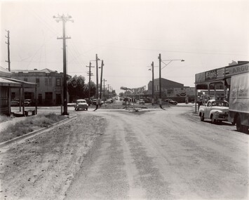
Photograph - Black and white, c. 1956
Strip shopping and ample parking were features of suburbs in the middle of the twentieth centuries. Cars were still considered a luxury, although that would soon change, and local, independent shops serviced local areas.During the post-war years, the municipality of Moorabbin experienced a population boom. The 'newcomers' were predominantly returnees from the war who were marrying and establishing families; those from the old inner-suburban areas who were moving away from rented premises to establish their own homes on cheap land. The 1950s were a time of immense growth for the area now known as City of Kingston.Black and white photograph of the intersection of Centre and East Boundary roads, Bentleigh East. Several cars are visible both in the foreground and background, and the intersection includes a roundabout. The street is lined with poles to carry electricity cables, and the roundabout is dotted with four poles for electric street lights.Handwritten in blue ink: 56 - 230 Handwritten in red ink: 82% Handwritten in black ink: Ch. 6shopping strip, cars, suburbs -
 Melbourne Legacy
Document - Document, report, (H52) The Way Ahead: a paper approved by Board of Management for dissemination to all members of the Legacy Club of Melbourne, 1979
Supplement to the Melbourne Legacy Bulletin No. 2463 which discusses how the Club should be structured after 1979, dated 27/6/79. It notes that the number of children being cared for was diminishing rapidly and immediate action should be taken with regard to the recruitment of Legatees and the adjustment of Branch boundaries. In 1978 the number of Junior Legatees had dropped to 3103 and by 1988 this figure was expected to be 280. However the 16,654 Legacy widows in 1978 was expected to increase to 24,700 in 1993. The work was split between 15 Branches, but the adjustment of Branch boundaries was not investigated in detail. Resulted from a Review CommitteeIllustrates the changing role of Melbourne Legacy during the twentieth century.Pale blue foolscap copy paper x 4 pages, printed both sides.'H52' in blue ballpoint on first page. Date crossed out in red ballpoint.organisation structure, review committee, review, objectives -
 Bendigo Historical Society Inc.
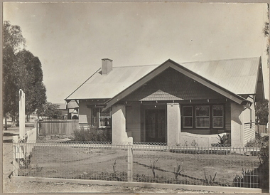
Photograph - T C WATTS & S0N COLLECTION: RUSSELL AND OLINDA STREETS, BENDIGO, 1930
In 1931 electoral rolls, Eric Robert Kevil (1901- 23/5/1980) and his wife lived at 129 Russell St. He had married Edna May Cornish in 1921. By 1943 they had both moved to 77 Valley Pde., Camberwell.Black and white photograph mounted on rectangular brown board. House, pale weatherboard with rough cast above. Corrugated iron roof, one chimney, shingles in gable over verandah, diamond leadlights, bow window L.H., recessed front door rough east surround and pillars to verandah, concave top to verandah wall. Paling side and rear woven wire front and near boundary, lintel over front gate, letterbox. Written on back of photoboard ' Mr. Kevill's Russell and Olinda St., built to order £850 sold, 15.6.34' Date Stamp on back '11 April 1930'Frank A. Jeffree, Bendigorussell street, e.r. kevil, russell street bendigo, t.c. watts and son -
 Bendigo Historical Society Inc.
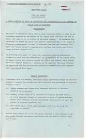
Document - BASIL MILLER COLLECTION: BENDIGO SAYS GOOD-BYE TO THE TRAMS, c1972
... of operating street tramways within their boundaries. Cabs, Battery... of operating street tramways within their boundaries. Cabs, Battery ...13 April 1972. Bendigo Says Good-bye to the Trams. A1 sheet - double sided. Tramway history 1890 - 1972, 2 copies. At the stroke of 5 pm from Eaglehawk Town Hall clock 82 years of history will end as the last tram makes its sentimental journey to the city, while at the Bendigo Cemetery - the Quarry Hill line terminus - another tram will be leaving for its last resting place. Other articles include: Four Eras, of trams. The Trammies, covering Ballarat, Geelong in the form of a poem. 1927 and all that, by Basil Miller, remembering his 45 years of service with the trams. How it all started, The twin communities of Sandhurst and Eaglehawk were relatively early in considering the possibility of operating street tramways within their boundaries. Cabs, Battery Cars, Construction, Strikes, Bendigo 1890 to 1972 - Tramways. Man and his Mates, continued from previous page, Explosion, Touchy Task, A Quickey, Horrors. Electric in 1903, There was excitement galore in the City during April, 1903 - and the Advertiser recorded the progress of the new-fangled electric machine. One man's Memories, Tough times, humour, tragedy and comradeship - they all came flooding back as former Bendigo tramway-man Tom Griffiths recently turned the clock back. Keb Sir Keb Sir? 'Keg sir? Tram off the line,' was the call of the cabbies when a train pulled in at the Bendigo railway station. Altered Shopping Trend, With advent of the electric tram in Bendigo came change in shopping habits.bendigo trams -
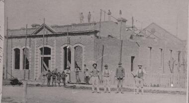 Bacchus Marsh & District Historical Society
Photograph, Mechanics Institute and Hall Main Street, Bacchus Marsh 1883
A Mechanics Institute in Bacchus Marsh dates from sometime in the 1850s. The first Mechanics Institute Hall was erected in 1858 in Young Street.(Victorian Collections no.659.) In 1883 a new and larger Mechanics Institute Hall was built in Main Street. The new hall cost 2,000 pounds to construct. It was opened by Sir William Clarke on 21 November 1883. The Mechanics Institute Library and rooms at the front of the hall were removed when the building was renovated in 1971. The building still stands and is used as a public hall.Small black and white 'carte de viste' style unframed photograph on card with gold border framing photograph. Housed in the Jeremeas Family Album which contains photographs of Bacchus Marsh and District in 1883 by the photographers Stevenson and McNicoll. The photo is of a substantial brick building under construction. Scaffolding support poles line the front and also can be seen on the top and back of the building. On the rooftop stand three workmen, with a further seven men standing at the front. Three men lean or stand casually at the front in casual poses. Four men stand in a line in another group on the roadway, perhaps indicating that they are master craftsmen. One of these men holds a tool of his trade, resembling a bricklayer’s mortar board. Six boys can be seen, four in a rather jaunty pose. In an indication of its public significance, the four front windows and door are arched and have decorative stone work in the side panels. A picket fence marks the boundary of the adjacent block.Printed On the front: Stevenson & McNicoll. Photo. 108 Elizabeth St. Melbourne. COPIES CAN BE OBTAINED AT ANY TIME. On the back: LIGHT & TRUTH inscribed on a banner surmounted by a representation of the rising sun. Copies of this Portrait can be had at any time by sending the Name and Post Office Money Order or Stamps for the amount of order to STEVENSON & McNICOLL LATE BENSON & STEVENSON, Photographers. 108 Elizabeth Street, MELBOURNE. stevenson and mcnicoll 1883 photographs of bacchus marsh and district, mechanics institutes, halls, bacchus marsh mechanics institute -
 Bendigo Historical Society Inc.
Plan - MARKS COLLECTION: PLAN OF UNDERGROUND SURVEY G. DENNIS MINE
Plan drawn on heavy parchment 'underground survey G. Dennis' printed on top of plan. Plan shows boundary lines and peg site. P. Bonati claim marked on bottom of plan. B. Letter with plan on letterhead 'City of Sandhurst, Town Hall, July 2nd. 1873' Addressed to Mr. George Dennis, Sir, In reply to your letter of the 19th. Ulto I am empowered to state that subject to the formation of the road referred to, your existing rights are conserved, and the council will undertake not to object to the renewal of your lease. The only conditions being that you shall not sink a shaft in the street or attempt to obstruct it when formed. I have the honour to be, Sir, your obedient servant, Geo Fletcher, Town Clerk.bendigo, mining, g. dennis claim -
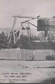 Bendigo Historical Society Inc.
Photograph - CENTRAL RED WHITE AND BLUE MINE, c1900s early
... , at the front of the photo is Fadies Whim in Nettle Street, Iron Bark... Street Bendigo/Golden Square boundary. Markings/Inscriptions ...Black and White photo. On the right is the Central Red White and Blue Mine at the corner of Lilac and Honeysuckle Sts, at the front of the photo is Fadies Whim in Nettle Street, Iron Bark. Landscape view in background most likely High Street Bendigo/Golden Square boundary. Markings/Inscriptions: Central Red White and Blue Mine, Corner Lilac and Honeysuckle Sts. Fadies Whim, Nettle Street, Photo Taken early 1900s. Central Red White & Blue Whim. On rear of photo: Evolution in mining apparatus is illustrated in this photograph - Bendigo. 2 Royal Historical Society of Victoria, Bendigo Branch stamps on rear also.central red white and blue mine, mining, lilac, honeysuckle, fadies whim, 1900s, poppet head -
 Warrnambool and District Historical Society Inc.
Document - Warrnambool City Council Preliminary Report Industrial Estate West Warrnambool, E Johnson, 9 March 1973
This preliminary report relates to 32½ acres of council owned land in West Warrnambool bounded on the North by McMeekin Road, on the East by Scott Street, on the South by Evans Street and on the West by the rear boundaries of properties facing Landmann and Granter Streets. In 2010, West Warrnambool was the largest of Warrnambool’s existing industrial areas, comprising approximately 109ha of industrial zoned land, the majority of which (101ha) is zoned IN1Z, with the remainder zoned INZ3. The area comprises a mixture of lot sizes supporting a diverse mix of industries. Larger parcels are occupied by the abattoirs, scrap metal industries, freight, the Council Depot and storage. Smaller lots are occupied by smaller manufacturers and wholesalers and service industries. [Ref: Warrnambool Industrial Land Use Review. Mesh Pty Ltd July 2010]This document is a preliminary report prepared by the Warrnambool City Council Engineer in March 1973 and provides an example of the planning process undertaken to develop one of Warrnambool's industrial areas. It contains details and costings of the proposed subdivision. Two foolscaps size pages of typewritten information. A detailed topographical map of the area with areas highlighted in blue, red, green, blue and purple pen.warrnambool city council, west warrnambool, industrial estate -
 Eltham District Historical Society Inc
Photograph - Digital Photograph, Alan King, Shillinglaw Cottage, 6 January 2008
Covered under National Estate, National Trust of Australia (Victoria) Local Significance and Heritage Overlay, Nillumbik Planning Scheme. Published: Nillumbik Now and Then / Marguerite Marshall 2008; photographs Alan King with Marguerite Marshall.; p95 Thanks to an Australia first effort by local residents, the historic Shillinglaw Cottage still survives. The cottage at Panther Place, Eltham, once stood about 100 metres away on Main Road. But in 1963 it faced demolition to make room for the Eltham Shire Offices (since demolished). However residents rallied to save Shillinglaw Cottage and became the first in Australia to remove and reconstruct an early settler’s brick building. A fundraiser was the residents’ compilation of loved recipes into the cookery book, Flavour of Eltham. The cottage, built in the late 1870s by noted pioneer builder George Stebbing, is one of Eltham’s earliest buildings and associated with significant early settlers. It is on the National Estate and National Trust Registers. The cottage was constructed with handmade bricks in the Flemish Bond style, typical of cottages and farmhouses in Flanders, Europe. It features burnt ‘header’ bricks over the façade, which gives a chequered effect. The roof is made of slate, while the windows are 12-paned sash with relieving arches. It is not clear who were the first owners of the cottage. The National Trust claims that Stebbing built it for farmer Thomas Cochrane.1 Others say Cochrane first owned the land but Stebbing was Shillinglaw’s first owner and remained so until 1887. The Shillinglaw family then bought it and lived there for around 80 years until 1963 when they sold it to the Eltham Council.2 Farmer Thomas Cochrane bought the Shillinglaw Cottage site from land developer Josiah Holloway. The site was the largest in what Holloway called Little Eltham, of some 30 acres (12 ha), extending along the creek from Henry Street to Luck Street. In 1874 Cochrane sold the land to George Stebbing. Meanwhile in 1861, Stebbing was the owner and occupier of a house at Pitt Street, Eltham, which he had built. Evelyn Observer journalist James Rossiter rented the Pitt Street house, then in 1881 Phillip Shillinglaw occupied it. Stebbing constructed several buildings of note in the area, including the Uniting Church at John Street, the building beside it – a former bank – and St Margaret’s Church of England in Pitt Street. Stebbing was also an Eltham Shire Councillor from 1871 to 1873 and a trustee and treasurer of the Eltham Wesleyan Church.3 In the 1870s he is recorded as the owner of up to five houses. Earlier he had been described as a bricklayer and later became a farmer. In 1882 Stebbing returned to the Pitt Street house and Shillinglaw occupied the new house in Main Road, which he owned from 1887. Shillinglaw was a prolific poet and preached at the Eltham Primitive Methodist Church, where he also served as Sunday School superintendent and led the Young People’s Society Christian Endeavour. The Shillinglaws saw many changes in their property’s boundaries – the major one occurring at the turn of the century when land for the railway and Eltham station was acquired from their holding. The northern part of the remaining land was then used for some of the first commercial developments in what was to become the Eltham Shopping Centre. Later still, the land immediately north of the cottage was bought by the Eltham War Memorial Trust for the War Memorial Buildings and the fire station. The Trust’s land eventually passed to the council. The council bought the remaining two acres (0.8 ha) with the house, and with the exception of the commercial development between the fire station and the post office, all of the former Shillinglaw land is owned by the council or government instrumentalities.4 Since the late 20th century, the cottage has had varied uses, such as a handcrafts store and as a restaurant.This collection of almost 130 photos about places and people within the Shire of Nillumbik, an urban and rural municipality in Melbourne's north, contributes to an understanding of the history of the Shire. Published in 2008 immediately prior to the Black Saturday bushfires of February 7, 2009, it documents sites that were impacted, and in some cases destroyed by the fires. It includes photographs taken especially for the publication, creating a unique time capsule representing the Shire in the early 21st century. It remains the most recent comprehenesive publication devoted to the Shire's history connecting local residents to the past. nillumbik now and then (marshall-king) collection, shillinglaw cottage -
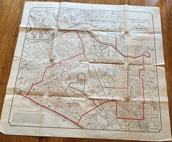 Melbourne Tram Museum
Map, Department of Lands and Survey Melbourne, Commonwealth Electoral Division of Fawkner, 1-10-1912
Shows a detailed street plan of South Melbourne, Albert Park, Prahran, South Yarra and parts of Melbourne in 1912. Used to mark the electoral boundaries of the Commonwealth Electoral Division of Fawkner. Shows all the then cable tram lines, rail lines and the electric line of the PMTT along with docks, gardens and significant buildings.Gives details of the Fawkner Electoral district in 1912.Folded sheet - Map - Commonwealth Electoral Division of Fawkner - two colours showing the subdivisions and polling placesmelbourne, fawkner, tram lines, cable trams, maps, electoral maps, south melbourne, albert park, prahran -
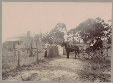 Linton and District Historical Society Inc
Photograph, Conversation at the Front Fence, undated
Black and white image mounted on light grey card. Image shows a weatherboard house in background, trees and a boundary fence. Two women are standing at the fence. Other side of the fence is a horse drawn cart with a man and a young female seated there.rural life, horses, horse drawn vehicles, houses -
Glen Eira Historical Society
Book - Ormond Amateur Football Club
... McKinnon High School Walnut Street Bailey Reserve Boundary Road ...This file contains two items: 1/A 50 page book on history of Ormond Junior Football Club, from its days as St. Annes Football Club to its amalgamation with Ormond Amateur Football. Book compiled by Claire Barton from AGM meetings 2009. 2/A copy of six football club addresses from the city of Moorabbin Community Directory 1987.ormond junior football club, stock jack, stevens harold r., st. annes church hall, halls, maylan street, east bentleigh, bentleigh mckinnon youth club, clubs and associations, smith brian, scott r. ken, steve stevens, keane adrian, oaten max, dight john, southam david, patterson don, stait ron, ceresa jack, forward cyril, moorehouse bob, forward may, heggert joan, morris jill, brabner martene, williams margaret, jackson judy, mcinery loris, mckinnon high school, walnut street, bailey reserve, boundary road, dowling russell, miller ian, keane david, starke neil “speedie.”, red cross, schweppes, sponsors, claremont junior football club, glenorchy football club, hudson peter, heggert keith, hilton ken, ormond blues, barassi ron, dargavel marita, beggs mr., smith mr., kaighal mr., gunn e. e., morcum glen, cochrane b., clark d., tate geoff, dargavel b., pappas sid, melbourne football club, brabner cameron, siderellis terry, morris wayne, burns robbie, kemp malcolm, siderellis tim, tinsley warwick, grant tom, middleton mick, dowling ian, clarke grant, young morgan, dawes bernie, dawes gerry, montgomery peter, peebles gordon, bentleigh bulldogs football club, mckinnon reserve, sheehy marnie, doble john, kerford phil, gleeson ian, rollasom brian, beynon wayne, societal events and activities, sheehy fay, wood ron, mckinnon butchers, brabner graham, begg john, moorabbin ufa, melbourne football club little league, interleague football matches, brandella cup, mccarthy justin, lough chris, montgomery stephen, carey tim, roe anthony, hardy chris, mccarthy justin, thomas matthew, perry richard, birch david, king denise, sparrow family, wilson ron, dupe stephen, karrageorgiov chris, hardy chris, borrett john, edgells darren, sparrow peter, ormond amateur football club, duncan john, beard j., warren e., pearson martin, waldron gary, marwood shane, collingwood vfl, jackson ricky, melbourne vfl, smith terry, richmond vfl, perkin phil, bentleigh juniors, beham m., neville david, taylor stephen, palmer tony, o’hara matt, ‘the cedric keane perpetual trophy’, st. anne’s football club, ormond east, valkstone, glenhuntly, st. patricks, primary schools, st. kilda junior leagues, lightening premiership, measures paul, msjfl u15 best and fairest, birch david, eishold lewis, eishold rohan, murrumbeena j. f. club, vic kick clinic, lough david, pennacchia luigi, best and fairest, buckley mark, rombotis john, d’astoli michael, msjfl team, king geoff, stumbles roger, williams cameron, byron noel, gillot heather, lehner elaine, oakleigh districts, stevens h. r., forward c. c., beggs j. w., scott k. k., kaighan t. a., dargavel m. mrs., forward n. c., keane m. j. mrs., woodhouse r. j. (dec), smith b. w., keane c. b., morgom g. m. (dec), dowling r. a., starke n., montgomery p., pearson p., kerford p., king d. mrs., lough d., perkin p., lehner e. mrs., russell r., interleague team, byron jason, guzzo anthony, kinsella trent, pym dominic, turner davis, b. f., artz ben, ralogaivav joe, jones alan, martin rick, editor, barton claire, australian rules football, sporting clubs, ormond, mckinnon, bentleigh, sports officials, committees of management, murrumbeena