Showing 8590 items
matching bridge-spike
-
 Ballarat Heritage Services
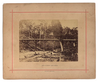
Photograph - Mounted photograph, Nicholas J. Caire, View of Sailors' Creek Bridge, c1877
Original photograph of a bridge at Sailors' Creek, near Daylesford. daylesford, bridge, nicholas caire, sailors' creek -
 Lorne Historical Society
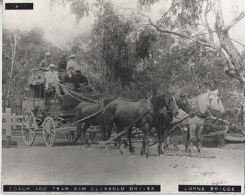
Photograph - Black and white photograph, mounted, Coach & Team, Sam Clissold driver. Lorne Bridge
Print mounted on board showing coach crossing Erskine RiverCoach & Team - Sam Clissold driver. Lorne Bridgebridge, coach, sam clissold, clissold, lorne bridge, horse driven, 1617, erskine, coach-driver -
 Ringwood and District Historical Society
Photograph, Ringwood foot bridge, west side of Warrandyte Rd. 1919
Written on back of card, "Ringwood foot bridge, 1919". -
 Ringwood and District Historical Society
Photograph, Warrandyte Rd. bridge, Ringwood. Sept. 1987
Written on back of photograph, "13.9.87. Warrandyte Rd. bridge". -
 Ringwood and District Historical Society
Photograph, Warrandyte Rd. bridge, Ringwood. April 1987
Written on back of photograph, "8.4.87. Warrandyte Rd. bridge". -
 Ringwood and District Historical Society
Photograph, Two photos taken at Deep Creek Road bridge c.1973
Typed below photograph, "Deep Creek Road bridge..." -
 Eltham District Historical Society Inc
Photograph, Bridge Street, Eltham, c. Sep. 1966
Last house on right is No. 122. The three houses on right remain relatively original in present time, the two visible houses on left have been substantially altered or replaced. Bridge Street ended at this point but has since been further extended eastBlack and white photographic printOriginally located in a Filmpro King Size Prints processing envelope $3.01 Shire of Eltham 9/9/66 and noted as Calrossie Ave area and crossed out Eltham-Yarra Glen Road, Bridge Street to Elsa Court existing conditions mid 1967eltham, infrastructure, road construction, roads, bridge street -
 Melbourne Tram Museum
Photograph - Digital Image, Kevin O'Reilly, series of three images of the Hawthorn Bridge over the Yarra, c1930, c1930's
Image from CD (Compact Diskette for use in computers) - see Reg Item 135. A series of three images of the Hawthorn Bridge over the Yarra, c1930, during the era with problems with the bridge. See separate article for more details. Richmond 6, Richmond, Richmond 3 on the CD as original files. .1 - Looking from the south west, at the Hawthorn bridge with the temporary wooden bridge being constructed on the south side. Has the cable tram depot in the photo and part of the Burnley racing course. Temporary track on the north side of the steel bridge and crossings can be seen. .2 - Looking along Bridge Road to the east with Hawthorn Bridge in the middle of the photograph. Shows the industrial and residential areas, Hawthorn Railway Station and part of the Burnley Race course, the cable tram depot building. W class tram in Church St Hawthorn and W class tram crossing the bridge on the north side temporary track. Note the cable tram used as a shelter on the north east corner of the bridge. .3 - Looking south along River St towards Bridge Road, with the Yarra River and Hawthorn Bridge on the left side of the photograph. Shows the industry in the area at the time, wool and skin Merchants, north side of the cable depot, housing and the outlook to the river!trams, tramways, hawthorn, yarra river, burnley, richmond, hawthorn bridge -
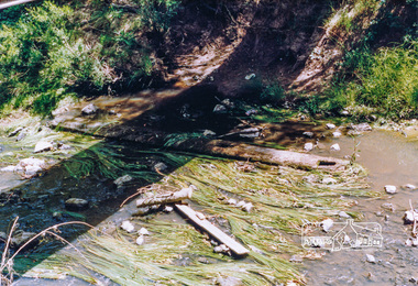 Eltham District Historical Society Inc
Photograph, Cross beam from old timber Main Road bridge over the Diamond Creek, 1992, 1992
Two colour photographs of old cross beam from original Main Road trestle bridge lying in creek bed. It is downstream from the current re-structured bridgebridges, diamond creek, main road, eltham south -
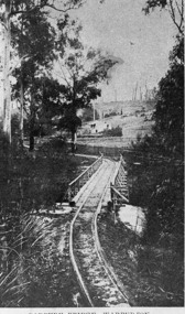
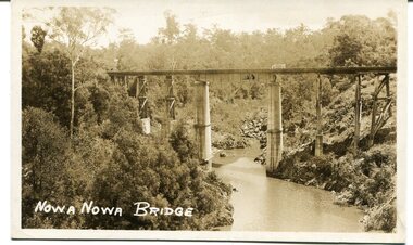 Orbost & District Historical Society
black and white photograph, first half 20th century
This appears to be the Boggy Creek bridge and to have been taken at Nowa Nowa. The Boggy Creek Bridge was built in 1916 as part of the Bairnsdale to Orbost extension to the main Gippsland Railway, and is situated in the middle of the township of Nowa Nowa, crossing a steep-sided and well-timbered creek-valley. This section of the line closed in 1987.This bridge plays a major part in the identity and history of the town of Nowa Nowa, since Boggy Creek’s steep sided valley divides the township into two components. It is part of the East Gippsland Railway line.A black / white photograph / postcard of a tall railway bridge, with concrete pylons in the centre,There is a creek below.on front - bottom left - " NOWA NOWA BRIDGE"boggy-creek-railway-bridge nowa-nowa railway-bridge east-gippsland-railway orbost-bairnsdale-railway -
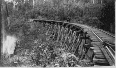
 Orbost & District Historical Society
black and white photograph, mid 1930s
This is a photograph of McKillop's Bridge probably taken just after its rebuilding. The current McKillop’s Bridge was built by the Country Roads Board in two stages between 1931-36, during which its height was raised after the original bridge superstructure was washed away in record floods of January 1934, prior to its original official opening. In its reconstructed form the original concrete abutments were turned into additional piers and the welded-steel trusses were cantilevered back over them to meet the new higher road approaches. "McKillops Bridge was Heritage listed due to its social and technological significance – the steel trusses' arc-welded construction technique was a pretty big deal in the 1930s. It was once an important route for cattlemen, who used the ford across the Snowy in the years preceding the bridge's existence"This is a pictorial record of McKillop's Bridge just after its construction.A black / white photograph of a wooden bridge across a river. At the bottom right is a man with his back to the camera. He is looking at flood debris on the bank. At the bottom left are two men near a pylon.on back - McKillops Bridgebridge-mckillop's snowy-river-bridge -
 Whitehorse Historical Society Inc.
Photograph, Railway Bridge, Brunswick Road, Heatherdale - Now Cochrane Street - runs through to Orient Avenue, C.1958
Black and white photo of Railway Bridge, Brunswick Road, Heatherdale.o'rourke, l. -
 Whitehorse Historical Society Inc.
Photograph, Lake Road Bridge, 1962
Black and white photo of bridge over Lake Road, Blackburnlake road blackburn, lake road bridge blackburn -
 Stawell Historical Society Inc
Photograph - Stanley Steamer of Old Delley's Bridge, Stanley Steamer on Old Delleys Bridge c1922, C 1926
Transport Halls Gap50 M North of New Curved Bridge c 1926 -
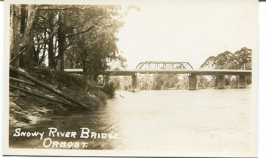 Orbost & District Historical Society
black and white photograph, first half 20th century
This is a photograph of the second Snowy River Bridge at Orbost. The section in the central span could have been built after flood damage. This bridge over the Snowy River was opened on July 4 1922. It was constructed in 1922 alongside the previous suspension bridge. Its building was a combined effort of the Victorian Railways and the Country Roads Board at a cost of 35,000 pounds. It was replaced in 1976 by the present bridge after several major floods.This bridge was replaced in 1976 after several major floods.A black / white photograph / postcard of a bridge over a river. It has what looks like a bo girder in the central section. On the left is the river bank.on front bottom left - "SNOWY RIVER BRIDGE"orbost snowy-river-bridge transport-bridge -
 Eltham District Historical Society Inc
Photograph, Old Lower Plenty Bridge and Hotel
Colour photograph of Lower Plenty Bridge from the west prior to opening of new bridge. Hotel in background. 4 x 6 print and also laminated 8 x 10 print.lower plenty, main road, plenty river, golf club hotel, hotels, bridges -
 Port Melbourne Historical & Preservation Society
Document, Public Records Office Victoria (PROV), Record of a disaster; The collapse of West Gate Bridge, Dec 2003
Record of a disaster; The collapse of West Gate Bridge 3 pages from "Proactive" magazine of PROV Photographs and Text of the West Gate Bridge collapse and details of online exhibition "Disaster at Westgate"disasters, west gate bridge, public records office victoria, prov, engineering - bridges -
 Lakes Entrance Historical Society
Photograph - Murrindal River Bridge Murrindal Victoria, 1/03/2000 12:00:00 AM
Colour photograph of the timber bridge across the Murrindal River Murrindal Victoria. Also a second colour photograph showing approach to bridge with signs prohibiting cattle droving and use of side track.bridges, forest, civil engineering -
 Kew Historical Society Inc
Photograph - Chandler Highway Bridge, 1977
The heritage listed Fairfield Bridge was originally constructed for the Outer Circle Railway to bridge the Yarra River between East Kew and Fairfield stations. In the 1930s it was converted for vehicular traffic. In the 2010s a new concrete bridge was erected beside it to increase vehicular capacity.Print copy of the Chandler Highway Bridge, [formerly the Fairfield Viaduct of the Outer Circle Railway] showing the original position of the walkway beside the bridge. The POV is from the Fairfield side looking towards Kew. CHANDLER HWY BRIDGE OVER YARRA / OCTOBER 1977 / ORIGINALLY BUILT FOR OUTER CIRCLE RWYchandler highway bridge, outer circle railway viaduct, bridges -- kew (vic.) -
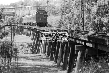 Eltham District Historical Society Inc
Photograph, George Coop, A Tait (Red Rattler) train bound for Princes Bridge crosses the Railway Trestle bridge, Eltham, 1981
A Tait (Red Rattler) train bound for Princes Bridge crosses the Railway Trestle bridge. Shire of Eltham Offices and library in background (now demolished). Carriages had swinging doors and were "hot boxes" in the summer with no air conditioning. Digital TIFF file Scan of 35mm Ilford FP4 black and white transparencyeltham shire office, eltham trestle bridge, red rattler, tait train, george coop -
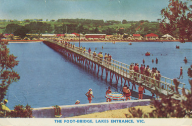 Lakes Entrance Historical Society
Photograph - Cunninghame Arm footbridge Lakes Entrance Victoria. c1955, Rose Series, 1955 c
Cunninghame Arm footbridge showing crowd on bridge, cars parked on Esplanade, new concrete wall between dunes and lake at south end of bridge Lakes Entrance Victoria. c1955. Also another colour postcard similar view of footbridge made by Murray Views donor Susan Samuel 2 January 2015 number 04272.1, 9 x 14 cmColour postcard taken from south end of the Cunninghame Arm footbridge showing crowd on bridge, cars parked on Esplanade, new concrete wall between dunes and lake at south end of bridge Lakes Entrance Victoria. c1955. Also another colour postcard similar view of footbridge The Foot-Bridge, Lakes Entrance. Vicrecreation, waterfront, land reclamation, gippsland lakes -
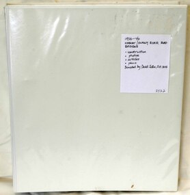 Orbost & District Historical Society
folder, Orbost Bridges - Snowy River Road Bridges, 1974 1976
This folder was compiled in October 2015 from documents, magazines. papers and photographs donated by David Jellie, engineer in charge 1974 - 1976. In early 1974, as an Engineer with the Country Roads Board, David came to Orbost as the Supervising Engineer for the construction of the new bridges which were part of an 8.4km Orbost bypass road design. This was a major project involving not only a new bridge over the Snowy River (including Lochiel Lagoon), but other bridges over Ashby’s Gulch and Watt’s Gulch. These new bridges were opened in November 1976 with the unveiling of a plaque on the eastern end of the $2.4M Snowy River Bridge. (ref. May Leatch)This item is a useful reference tool on the construction history of the Snowy River Road bridges.A white plastic folder - Orbost Bridges - Snowy River Road Bridges. it contains newspaper articles, booklets, photographs and documents relating to the construction of the Snowy River Road Bridge in 1974 -1976.on front cover - 1974 - 76 ORBOST / SNOWY RIVER ROAD BRIDGES * construction * photos * articles * plans Donated by David Jellie Oct 2015snowy-river-bridges jellie-david -
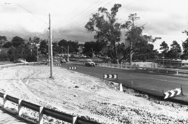
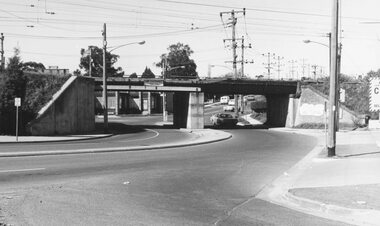
 Ringwood and District Historical Society
Photograph, Maroondah Highway West, Ringwood, 1965. Wantirna Road bridge, start of widening
Black and white photograph (2 copies)Written on rear of backing sheet: "Wantirna Road bridge- the start". -
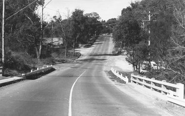
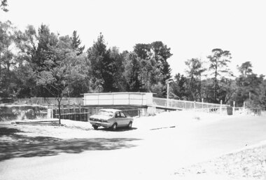
 Ringwood and District Historical Society
Photograph, Maroondah Highway West, Ringwood- 1973. Wantirna Road bridge, completed widening
Black and white photographWritten on back of photograph: "Bridge widened, Wantirna Rd, 1973 -
 Ringwood and District Historical Society
Photograph, East Ringwood Railway Bridge under construction 9/77
Written on back of each photograph, 'East Ringwood bridge, 9/77'. Catalogue card reads, 'East Ringwood Railway Bridge under construction 9/77?' -
 Upper Yarra Museum
Negative Photographic Reproduction, Parbury Bridge Warburton, 14.2.1983
Parbury Bridge Warburton Negative Black white. Scanned at 600 dpi.parbury bridge warburton tramway yarra river -
 Upper Yarra Museum
Negative Photographic Reproduction, The Powelltown tramline bridge
The Powelltown tramline bridge Black and White negative scanned at 600 dpipowelltown tramline bridge -
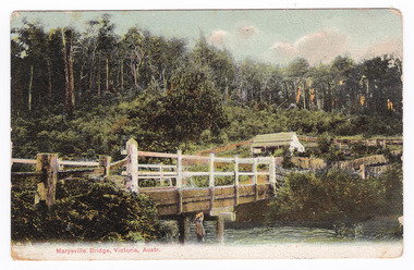 Marysville & District Historical Society
Postcard (Item) - Colour tinted postcard, Nicholas John Caire, Marysville Bridge, Victoria, Austr, 1878-1904
One of a series of postcards of photographs taken by socialite photographer Nicholas John Caire.One of a series of postcards of photographs taken by socialite photographer Nicholas John Caire. N.J. Caire had a great love for the area in and surrounding Marysville and in the late 1800's took many photographs of Marysville and its surrounds. N.J. Caire was born in 1837 in Guernsey. He arrived in Adelaide about 1860 along with his parents who encouraged his early interest in photography. He opened a studio in Adelaide in 1867 after traveling extensively throughout the Gippsland taking photographs. After marrying in 1870 he moved to Talbot in Victoria until 1876 when he opened a studio in the Royal Arcade in Melbourne. After 1885 N.J. Caire gave up his city work and made his home in South Yarra and devoted the rest of his life to outdoor photography, specializing in the bush, the gullies and the mountains of south-eastern Victoria.POST CARD This Space may be Used/ for Correspondence The Address Only to be/ Written Here. 88421 Dear Miss McNair./ We arrived home/ quite safely on Sat./ The children met/ us with Fran and/ Auntie Ethel at the/ Circular Quay. All/ were well and real/ glad to have us home/ again. We were so sorry/ we were too late/ for the train. We thought/ we saw Mr Mr McNair walking from/ the train. Love to ????/ Kisses for Ollie from A.M.G. Miss McNair/ Wattle Street/ Bendigo/ Victoriamarysville, victoria, nicholas john caire, bridge scene, 88421, postcard, souvenir -
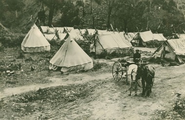 Lorne Historical Society
Photograph, Bell Tents at Bridge near Grassy Creek 1920
Tent encampment and horse trap near Grassy Creek Bridge 1920 -
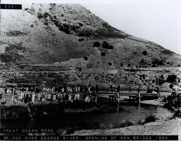 Lorne Historical Society
Photograph, St George River Bridge opening 1926
Photograph showing crowd at the opening of the bridge over the George River in 1926 g.o.r; george river bridge 1926;