Showing 457 items matching "cheltenham road"
-
 City of Moorabbin Historical Society (Operating the Box Cottage Museum)
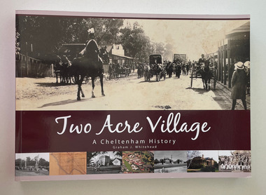
Book, Whitehead, Graham, Two Acre Village : A Cheltenham History, 2012
"The stories in Two Acre Village: a Cheltenham History tell of the steps taken by local people to entertain themselves, earn a living and provide opportunities for their children." from Foreword.274 p. : ill., ports. non-fiction"The stories in Two Acre Village: a Cheltenham History tell of the steps taken by local people to entertain themselves, earn a living and provide opportunities for their children." from Foreword.two acre village, cheltenham, history, pioneers -
 City of Moorabbin Historical Society (Operating the Box Cottage Museum)
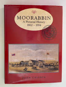
Book, Cribbin, John, Moorabbin : a pictorial history 1862-1994, 1995
Moorabbin: A Pictorial History is about a city that was. The book traces the story of Moorabbin for its beginnings to its end in 1994, from inside coverix, 214 p. : col. ill., ports.non-fiction Moorabbin: A Pictorial History is about a city that was. The book traces the story of Moorabbin for its beginnings to its end in 1994, from inside covermoorabbin, city of moorabbin, mckinnon, ormond south, benteligh, bentleigh east, heatherton, oakleigh south, highett, cheltenham -
 City of Moorabbin Historical Society (Operating the Box Cottage Museum)
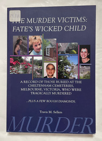
Book, Sellers, Travis M, The murder victims : fate's wicked child : a record of those buried at the Cheltenham cemeteries, Melbourne, Victoria, who were tragically murdered, 2011
... Cottage Museum) Joyce Park Jasper Road Ormond melbourne Cheltenham ...A record of those buried at the Cheltenham cemeteries, Melbourne, Victoria, who were tragically murdered.200 p. : ill. (some col.), ports.non-fictionA record of those buried at the Cheltenham cemeteries, Melbourne, Victoria, who were tragically murdered. cheltenham pioneer cemetery, cheltenham cemetery, murder victims, epitaphs, cheltenham -
 City of Moorabbin Historical Society (Operating the Box Cottage Museum)
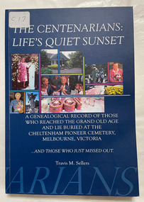
Book, Sellers, Travis, The centenarians : life's quiet sunset : a genealogical record of those who reached the grand old age and lie buried at the Cheltenham Pioneer Cemetery, Melbourne, Victoria ...and those who just missed out /, 2010
... Cottage Museum) Joyce Park Jasper Road Ormond melbourne ...A genealogical record of those who reached the grand old age and lie buried at the Cheltenham Pioneer Cemetery, Melbourne, Victoria ...and those who just missed outxi, 172 p. : col. ill., ports. (chiefly col.) Includes bibliographical references and index.non-fictionA genealogical record of those who reached the grand old age and lie buried at the Cheltenham Pioneer Cemetery, Melbourne, Victoria ...and those who just missed out centenarians, cheltenham cemetery, cheltenham, cheltenham pioneer cemetery -
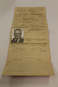 Dandenong/Cranbourne RSL Sub Branch
Durban South Africa Drivers Licence
It appears that Mr WA Benville was born in/near Durban South Africa on 6th Oct 1884. He served for Her Majesties Services for 222 days in the Boer war then came to Australia. He worked as Electrician at the GPO and lived at 180 High St.Kilda and joined the Australian Imperial Force, Australian flying Corps on 26/6/1917. Service No, 2320. Rank,.Air Mechanic 2nd Class. Roll Title Flying Corps Conflict Operation, First World War 1914-1918. Mr Benville Departed Melbourne on HMAT Port Sydney A15 on 9/11/1917. He was Married to Mrs Emily Madge Benville when he enlisted in Australia. Mrs Benville died on 10th July 1947. ( Buried at the Cheltenham Cemetery) Mr William Arthur Benville Died on 28th August 1976. Rest In Peace. Drivers licence to drive a Motor Car "William Arthur Benville" Natal Province District of Durban South Africa. Pink Cover.(The licence is written in English on left and Afrikaans on right. [We have used the English Inscriptions] Natal Province-Motor Vehicle and Road Traffic Regulation Ordinance 1937. (Ordinance No. 10 of 1937 as amended) Drivers Licence class of motor vehicle in which respect licence is granted Motor Car. 123659. Issued to Surname Benville, Christian Name William Arthur, Address 178 Florida Rd, Date of Birth 6.10.84, Fee Paid 10/- shillings This licence is hereby granted to the abovenamed person, whose photograph and signature (or right thumb impression) appear hereunder, to drive a motor vehicle of the class described above. (Signature) ?????? Registrar District DURBAN , Date 26Sep 1951 ( Line undecipherable ) he must present his licence at any revenue or borough licencing office for amendment. Change of Address Date New Address Recorded by. Endorsements PN 363-P. 15593/NW.756/4,000/22-6-49 -
 Bayside Gallery - Bayside City Council Art & Heritage Collection
Map, Department of Crown Lands and Survey et al, Moorabbin, County of Bourke, Government Roads, 1920
The cadastral map of the Parish of Moorabbin in Victoria (L.6104) shows parish boundaries and land ownership 1920 when Sandringham was a Town. The government roads have been coloured in red pencil.moorabbin, county of bourke, map, plan, land subdivision, land titles, foreshores, hampton, beaumaris, highett, cheltenham, department of lands and survey, land owners, cartographic material, brighton, sandringham, town of sandringham, government roads -
 Bayside Gallery - Bayside City Council Art & Heritage Collection
Map, Department of Crown Lands and Survey, Moorabbin, County of Bourke, c. 1918
The cadastral map of the Parish of Moorabbin in Victoria (L.6104) shows parish boundaries and land ownership c. 1918 when Sandringham was a Borough.moorabbin, county of bourke, map, plan, land subdivision, land titles, foreshores, sndringham, hampton, beaumaris, highett, cheltenham, department of lands and survey, land owners, cartographic material, borough of sandringham, brighton -
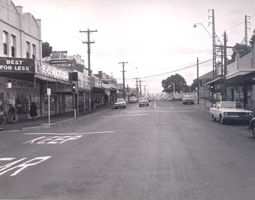 City of Kingston
Photograph - Black and white, Public Transport Corporation, c. 1960
This image is part of a larger collection of images from the Public Transport Corporation displaying train stations and streetscapes in what is now the City of Kingston.Black and white photograph depicting the run in to the level crossing at Cheltenham railway station, along Charman Road. The image also depicts a streetscape which includes a shopping strip. The level gates are closed and two cars can be seen stopping and waiting, while several more cars are parked on each side of the road.Stamped in blue ink on reverse: COPYRIGHT / Public Transport Corporation / For re-ordering photographs / Please quote negative No H3378 / Enquiries C/- PTC Photographic Unit / Telephone switchboard 619 111cheltenham, railway station, streetscape, surburb -
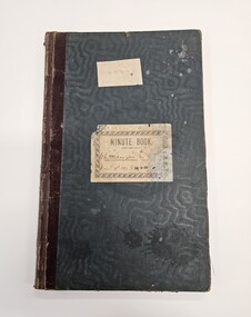
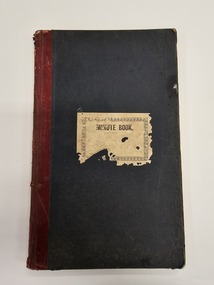 City of Kingston
Book - Minute book, Minute book of the Cheltenham Rifle Club, 1900
At a well attended meeting at the Mechanics Hall in Cheltenham in March 1900, attendees decided to form a rifle club. The newly appointed secretary of the newly formed Cheltenham Rifle Club, Mr E.C. Rippon, enrolled 55 new members on the day, and the club resolved to consult with the Defence Department regarding the suitability of Cheltenham Park for that purpose, and Moorabbin Council to grant the use of the park. By 1912 the club was already on the verge of disintegrating. The Cheltenham Park range had been disbanded two years earlier. A new, shorter range and club rooms were completed in October 1912. The club continued to have difficulties over location and funds, despite being granted an exemption from paying rates for the duration of the First World War. In 1919, a proposal to disband was put forward at a club meeting. Members rejected the proposal deciding instead to wait on the rumoured reopening of the Langwarrin range. By 1921 it became evident the Langwarrin range would not reopen. A resolution to wind up the organisation was put to the meeting and accepted.Green, cloth bound book with red leather spine. A white label is adhered to the front of the book with MINUTE BOOK printed in black text. The book is hardcovered and, inside, are approximately 186 pages which have been filled with handwritten text as meeting minutes and lists, including a list of commitee officers. The inside fly pages are decorated with blue and red marbling.Handwritten text on the white paper adhered to the front of the book is no longer legible.cheltenham, sport, club, rifles -
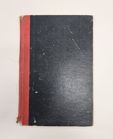
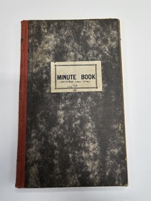 City of Kingston
Book - Minute book, Minute book of the Cheltenham Junior Tennis Club, 1923
This minute shows committee members and participants in the Cheltenham Junior Tennis Club, as well as their activities over the years 1923 to 1948. Hardcover book with marbled appearance and white paper label on the front. Handwritten in blue ink on paper label: CHELTENHAM JUNIOR TENNIS / CLUB / 1945cheltenham, sport, tennis, committee -
 City of Kingston
Book - Minute book, Minute book, Cheltenham Junior Tennis Club, 1897
This minute shows committee members and participants in the Cheltenham Junior Tennis Club, as well as their activities over the years 1897 to 1923Harcovered green book with burgundy spine and two white labels adhered to the front of the book. Note the labels do not agree on content.Typed in black ink on first white label adhered to front: C. J. T. C. Handwritten in black/blue ink on second label: Cheltenham Lawn [indecipherable] / March 31st 1987 to 29.6.23cheltenham, sport, tennis, committee -
 City of Kingston
Book - Minute book, Minute book, Cheltenham Community Hospital, 1938
The Mordialloc-Cheltenham Community Hospital was a hospital in the suburb of Parkdale. Residents of Mordialloc and Chelsea worked towards a community hospital from the late 1930s. Having a community hospital meant residents who required routine surgery did not need to travel into Melbourne to the larger established hospitals. This was important at a time when few people had their own transport. For many years the Mordialloc Carnival Committee contributed to the cost of building the hospital, with one of its contributions to the ‘opening day’ appeal amounting to one thousand pounds, adding to the several thousand already committed. Construction work commenced on the Mordialloc-Cheltenham Community Hospital in 1950. on a site between Booth St and Carrier Ave on the Nepean Highway in Parkdale. The hospital opened in 1953 and serviced the community until 1996. On 1 August 1995, the hospital became a part of the Southern Health Care Network. The former hospital site is now the main location of Central Bayside Community Health Services.Black hard cover book with red spine. cheltenham, mordialloc, hospital, parkdale, health -
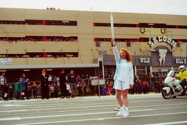 City of Kingston
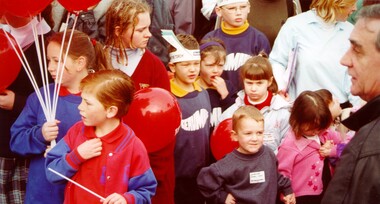
Photograph - Colour, 31 July 2000
The Olympic Games were held in Sydney in 2000. The Olympic torch progressed through Australia and prominent sporting or cultural identities were invited to carry the torch through their local areas.Colour photograph of Naomi Milgrim, CEO of Sussan Fashions, outside Westfield Shopping Centre Cheltenham (Southland), participating in the Olympic Torch Relay. Behind her a crowd can be seen gathered to watch the relay. There is a motorcycle police officer in a high visibility jacket to the right. Spectators can be seen on the roof of the building.Handwritten on reverse in black ink: CEO Sussan Fashions / Naomi / Milgrimolympics, torch relay, cheltenham -
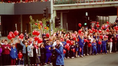 City of Kingston
Photograph - Colour, 31 July 2000
The Olympic Games were held in Sydney during 2000. The Olympic torch progress through Australia and prominent sporting or cultural identities were invited to carry the torch through their local areas. The relay was accompanied by large crowds.Colour photograph depicting the crowd in attendance at Westfield Shopping Centre, Cheltenham, during the 2000 Olympic Torch Relay. There are people lined up along the street, many carrying red balloons.olympics, torch relay -
 City of Kingston
Photograph - Colour, 31 July 2000
Colour photograph depicting a portion of the crowd in attendance to watch the Olympic Toch relay.Colour photograph depicting children who have been spectactors for the Olympic Torch relay at Westfield Shopping Centre, Cheltenham, during July 2000. One child is holding a bunch of red balloons. olympics, torch relay, cheltenham -
 City of Kingston
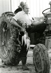
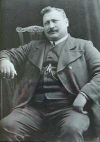
Photograph - Black and white, Moorabbin News, 1963
Francis (Frank) Wilbur Le Page was mayor of Moorabbin between 1980 - 1981, and again in 1984 - 1985. He was a lifelong resident of the region and also a third generation market gardener.In approximately 1854, Nicholas Le Page moved his family from Prahran to Cheltenham. Two years earlier, they had arrived in Melbourne from Guernsey Island. Nicholas Le Page was a tailor and his wife was a dressmaker. They decided to move into market gardening instead. Their son, Everest, married Lynda and Francis Wilbur Le Page was born in 1919. He attended Cheltenham State School where he completed his Merit Certificate in grade eight before studying bookkeeping, shorthand and typing at Bradshaw and Everett Business College in South Melbourne. Both Frank’s grandfather and father were active in local government. Francis Thomas Le Page was a councillor for 25 years and served a term as shire president in 1902. Everest, his son, was a councillor for the City of Moorabbin for 28 years and was mayor on two occasions. Frank also served two terms as mayor, first in 1980 and again in 1984. Frank died on 14 July 2008.Black and white photograph of Frank Le Page stepping down from a tractor, with a bunch of parsnips in his right hand.Pink coloured paper adhered to reverse with black printed text and handwritten text in blue ink: STANDARD NEWS / Paper MOOR / Catchline Garden / Percentage 88% / Date 17-10-84 / Page 23le page, market gardens, tractor, moorabbin -
 City of Kingston
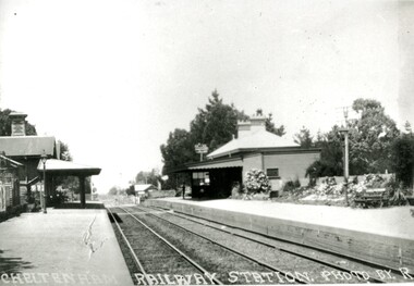
Photograph - Black and white, Percy Fairlam, c. 1920
... City of Kingston Parkdale Library 96 Parkers Road, Parkdale ...Cheltenham station was built in 1898 and serviced a primarily rural, market gardening community.The late 1870s saw the beginning of a massive program to construct railway lines throughout Victoria. One of these lines was from Caulfield to Frankston. A survey undertaken by J P Madden, an engineer employed by the railways, established the route, although this was later modified. At the time of the official opening of the line to Mordialloc no station buildings had been constructed despite the fact that tenders had been called in the Government Gazette of 26 May 1881 and subsequently in the Argus newspaper on 30 August 1881 for what became stations at Glenhuntly, Ormond, Bentleigh, Moorabbin, Highett, Cheltenham, Mentone and Mordialloc. However platforms and sidings were completed, ready to receive passengers. Cheltenham station opened in 1898.Black and white photograph of Cheltenham Railway Station with the two platforms separated by two sets of tracks. Each platform has a station house on it, and the one on the right hand side also has a garden and park bench.Handwritten in red ink on reverse: A7 / 75%cheltenham, trains, railway, railway station, railway crossing, suburbs -
 City of Kingston
Photograph - Black and white, c. 1910
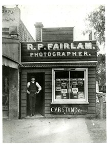
Percy Fairlam was an early 20th Century photographer living and working in Cheltenham. Fairlam captured important social and landscape scenes in and around the Cheltenham area including cliff faces, sea baths, and rock pools. With the outbreak of World War I (WWI), Fairlam began training in Seymour and documented preparations for war, comradeship and the voyage to France and war. Shrapnel to the shoulder, on 4 January 1917, saw Fairlam evacuated to England and resulted in him being separated from his personal possessions. As such, all these images have been lost. After the war, Fairlam moved into the family business and no longer pursued professional photography. However, he continued to take an interest in the art form capturing intimate family moments as well as continuing to capture social and landscape scenes.Black and white photograph of a Richard William Percy Fairlam (Percy Fairlam) standing in the doorway of a small wooden building. Above the doorway is a painted sign advertising it as the photography business of R.P. Fairlam. In the large window at the front of the shop a number of photographs can be seen.Handwritten in red ink on reverse: 115% Black printed text on a white round sticker on reverse: 71 -
 City of Kingston
Photograph - Black and white, Percy Fairlam, c.1910
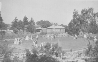
... City of Kingston Parkdale Library 96 Parkers Road, Parkdale ...Cheltenham Bowls Club, which was located to the rear of Cheltenham Railway station. This photograph was taken by Percy Fairlam, who opened a photographers shop in Charman Road. Percy took many of the best known photographs of Cheltenham at the turn of the century.This photograph was taken by Percy Fairlam, who opened a photographers shop in Charman Road. Percy took many of the best known photographs of Cheltenham at the turn of the century.Black and white photograph of people bowling at the Cheltenham Bowling Club, depicting a large area of lawn surrounded by trees and bushes, with buildings in the background. There are several groups of men and women standing on the lawn in front of a series of small balls.Printed in black ink on a round white sticker: 111 Handwritten in red ink: 90%. Handwritten in red ink: K000603leisure, bowls, games -
 City of Kingston
Photograph - Black and white, 20 December 1945
... City of Kingston Parkdale Library 96 Parkers Road, Parkdale ...Cheltenham is a suburb in the City of Kingston that was originally established as a rural market gardening community. The area is bordered by Highett, Mentone and Heatherton. The market gardens, farms and paddocks have gradually been sub-divided into housing and industrial estates. The Southland shopping centre is a major feature of the area.Cheltenham was established as a rural market gardening community. The Le Page family lived in Cheltenham since 1854 when Nicholas Le Page, a tailor from the Channel Island of Guernsey, bought two acres of land on Chesterville Road near Bernard Street to establish a market garden. Over the years the Le Pages purchased more land in the area. In 1875-76 Nicholas' son Frank and his wife Mary built 'Daphne Cottage' near the corner of Bernard and Wilson Streets. n the 1940s Frank's son, Everest Le Page, bought five more lots of land in Chesterville Road from the Tuck family. The Le Pages grazed horses, ponies and cows on this land, and grew pumpkins, carrots, parsnips, onions, potatoes and cabbages. Many buildings and locations within in Cheltenham commemorate the Le Page family's contribution to the Cheltenham community.Aerial photograph taken in 1945 of the Cheltenham district within the City of Kingston. The image includes Chesterville Road, the future site of Turner Road pool (now Waves) and Highett Reserve, (top left), Jellicoe Street, Argus Street, Bernard Street, Wilson Street, the Methodist Children Homes (now Southland), McIvor Street, Goulburn Street, Nepean Highway, Jamieson Street and Barker Street (bottom left), market gardens and paddocks. In the top centre of the image, "Daphne Cottage", the home of Frank T. Le Page is visible on the corner of Bernard and Wilson Streets. Much of the land depicted in this image was owned by the Le Page family. This image is possibly from the collection of aerial photographs commissioned by the Department of Crown Lands and Survey and taken by Adastra Airways.Black and white ink: 57250 White print: VIC-170 57250 20.12.45 Run 6 PROJ. No. 5 MELB. METROP AREA Black type 10200 FTS 30' LENS 20.12.45cheltenham, market gardens, industry, le page family -
 City of Kingston
Photograph - Black and white, 20 December 1945
This aerial photograph depicts the changing landscape of Cheltenham and Highett since WWII. Photographed in 1945, there is a mix of urban dwellings and industrial development and precedes the major transformation of Cheltenham with the development of the Southland shopping centre in the 1960s and expansion in the 1990s.A large part of Cheltenham was originally established as a rural market gardening community. The railway line and station brought urban development to the area and in the north, the Highett area was dominated by the Highett Gas Works. Cheltenham became a major destination for shopping in the 1960s with the opening of Southland.Aerial photograph taken in 1945 of Cheltenham and Highett within the City of Kingston. The image includes the Highett Reserve, (top right), the Methodist Children Homes (now Southland), Nepean Highway and Jamieson Street. Highett Gas Works is visible in the top left and the land now named William Fry Reserve at the intersection of Bay Road and Nepean Highway. A visible large parcel of land on the corner of Bay Road and Nepean Highway was developed in the 1990s as the west side addition to Southland. The densely vegetated area in the upper right sector of the image is now dense with housing. Tulip Grove, Heather Grove and Gilford Street are visible bottom left. This image is possibly from the collection of aerial photographs commissioned by the Department of Crown Lands and Survey and taken by Adastra Airways.Black ink: 57252 White lettering: VIC-10 57252 20.12.45 [lens information indecipherable] PROJ. No.5 MELB. METROP AREA Black pencil: 80highett, cheltenham, highett gas works, urbanisation -
 City of Kingston
Photograph - Black and white, 20 December 1945
This aerial photograph depicts the changing landscape of Cheltenham and Highett since WWII. Photographed in 1945, there is a mix of urban dwellings and industrial development and precedes the major transformation of Cheltenham with the development of the Southland shopping centre in the 1960s and expansion in the 1990s.A large part of Cheltenham was originally established as a rural market gardening community. The railway line and station brought urban development to the area and in the north, the Highett area was dominated by the Highett Gas Works. Cheltenham became a major destination for shopping in the 1960s with the opening of Southland.Aerial photograph taken in 1945 of Cheltenham and Highett within the City of Kingston. The image includes the Highett Reserve, (top right), the Methodist Children Homes (now Southland), Nepean Highway and Jamieson Street. Highett Gas Works is visible in the top left and the land now named William Fry Reserve at the intersection of Bay Road and Nepean Highway. A visible large parcel of land on the corner of Bay Road and Nepean Highway was developed in the 1990s as the west side addition to Southland. The densely vegetated area in the upper right sector of the image is now dense with housing. Tulip Grove, Heather Grove and Gilford Street are visible bottom left. This image is possibly from the collection of aerial photographs commissioned by the Department of Crown Lands and Survey and taken by Adastra Airways.Black type: Reverse lettering VIC-10 57252 20.12.45 [lens information indecipherable] PROJ. No.5 MELB. METROP AREA White lettering: Reverse writing 57252cheltenham, highett, highett gas works, urbanisation -
 City of Kingston
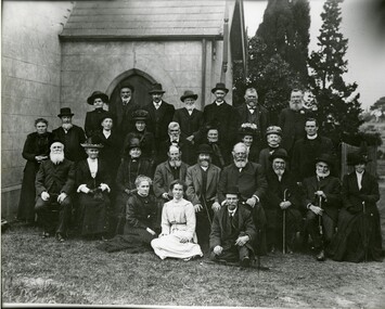
Photograph - Black and white, c.1913
Members of Cheltenham Presbyterian Church at a Jubilee Celebration. Included in the photograph are Reverend Malcolm McQueen, Reverend Finlay McQueen, Selena McQueen (nee Bruton), Reverend Malcolm McQueen, Teena McQueen, Mary Read, Tom Keiller, John Morey.The Pioneers Presbyterian Church Cheltenham was founded in 1858. In July 2023 BayChurch Presbyterian was formed from the union of St Andrew’s Presbyterian Church Mordialloc (commenced 1885) and Pioneers Memorial Presbyterian Church Cheltenham.A black and white photograph of a large group of men and women all looking at the camera, in front of a building. Handwritten in red ink: Rev Finlay McQueen / Selena (nee Bruton) McQueen / Rev Malcolm McQueen / Teena McQueen / Mary Read / Tom Keiller / John Moreyreligion, church, presbyterian, jubilee, church elders -
 City of Kingston
Photograph - Black and white, 20 December 1945
This photograph depicts a section of Cheltenham with a mix of housing and market gardens. The visible market gardens, farms and paddocks have gradually been sub-divided into housing, commercial and industrial estates. A large part of Cheltenham was originally established as a rural market gardening community. The railway line and station brought urban development to the area and the gradual subdivision of farmland and large land holdings for the development of housing. Aerial photograph dated 1945 of the Cheltenham area in the City of Kingston. Sydney Street (bottom left); Sinclair Street (top left); Weymar Street area off Wilson Street, Charles Street (botton right).White print VIC-170; 57197; RUN5; PROJ.No.5; MELB.METROP AREA Lens information [indecipherable] Small photograph: clockface Black ink: 57197cheltenham, market gardens, urbanisation -
City of Kingston
Photograph - Black and white, 20 December 1945
This aerial image covers a section of Cheltenham, with a large paddock yet to be converted to an industrial and later a commercial zone.This aerial photograph provides evidence of the changing landscape of Cheltenham and Highett since WWII. Photographed in 1945, the image features a large block of land now the site of site the major transformation of Cheltenham with the development of the Southland shopping centre in the 1960s and expansion in the 1990s.Aerial photograph of the Cheltenham area in the City of Kingston. This 1945 image is concentrated on the area between Bay Road and Garfield Lane with the distinctive bend into Jean Street. A large block of land runs between the Nepean Highway and the rail line. This is now the area occupied by the extension of Southland in the 1990s.cheltenham, southland, aerial photograph, highett -
City of Kingston
Photograph - Black and white, 20 December 1945
This aerial image covers a section of Cheltenham, with a large paddock yet to be converted to an industrial and later a commercial zone.This aerial photograph provides evidence of the changing landscape of Cheltenham and Highett since WWII. Photographed in 1945, the image features a large block of land now the site of site the major transformation of Cheltenham with the development of the Southland shopping centre in the 1960s and expansion in the 1990s.Aerial photograph of the Cheltenham area in the City of Kingston. This 1945 image is concentrated on the area between Bay Road and Garfield Lane with the distinctive bend into Jean Street. A large block of land runs between the Nepean Highway and the rail line. This is now the area occupied by the extension of Southland in the 1990s. It is a negative version of VKHC124.cheltenham, southland, market garden -
 City of Kingston
Photograph - Digital image, c.1918
Roderick William Mills, known as Saltbush Bill, was the inspiration for several poems by A.B. Paterson. Born at Balnarring in 1869, Mills earned the title of Saltbush Bill whilst working on a cattle station in Queensland. On these long droving trips, he learnt the art of cracking stock whips of many different lengths and sizes, a skill that earnt him £100 after a Melbourne saddler, J.K. Jennings, suggested that no man could crack a 65-foot stock whip in three tries. Saltbush Bill succeeded on his first attempt and decided to make a career in entertainment with his skill. Over his career he performed for royalty, travelled and performed extensively overseas and lent his skill to fundraising efforts, particularly during the war. His last concert was given in the Boomerang Hall in Dandenong in 1926.A local resident of the City of Moorabbin, Saltbush Bill was an ambassador for Australia and a literary inspiration to A.B. (Banjo) Paterson. Saltbush Bill, his wife Hannah Louise Porter and their 11 children lived in Old Dandenong Road, Heatherton, where Saltbush Bill and Hannah conducted a market garden for many years. Saltbush Bill is buried in Cheltenham's Pioneer Cemetery.Black and white digital imageheatherton, banjo paterson, saltbush bill, stock whip, entertainment -
 City of Kingston
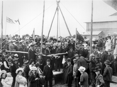
Photograph - Black and white, 1909
In 1880, the Melbourne Benevolent Asylum launched an appeal to raise funds to relocate away from the inner city. The location in North Melbourne was considered a great risk for the residents, particularly the 'old and feeble', in the event of an epidemic. In 1887, the secretary to the Premier of Victoria wrote to the Asylum, suggesting Frankston as a possible alternative to North Melbourne. The Asylum committee considered Frankston to be too far away. The Royal Commission into Charitable Organisations (1890) strongly recommended Cheltenham as the preferred location but the government failed to act on that recommendation. Former Asylum committee member, Mr James Hingston, bequeathed £25,000 to the Asylum on his death in 1902. After many more years of toing and froing, the foundation stone for the new asylum at Cheltenham was laid in 1909. It was almost two years later that the transfer of residents from North Melbourne to Cheltenham began. The move happened in stages over three days, with the first group of residents to move to Cheltenham being 125 women from the invalid wards. The Asylum continued to operate throughout the 20th Century and, in 1970, was renamed the Kingston Centre. The focus of services also changed. This photograph captures the laying of the foundation stone in 1909.Black and white image depicting a large group of citizens gathered to watch the laying of the foundation stone for the Benevolent Asylum in Cheltenham. There is a raised platform with a group of men dressed in suits standing on it. These appear to be the dignitaries for the day. There are flags flying in the background, others standing on poles at the corners of the raised platform. Handwritten in red ink on reverse: 50%cheltenham, charity, north melbourne, welfare -
 City of Kingston
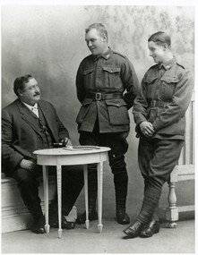
Photograph - Black and white, c.1917
Roderick William Mills, known as Saltbush Bill (left) with his sons, James Charles Mills (centre) and John James Mills (right), in London. In 1917 Saltbush Bill travelled from America to London after giving shows in various cities of the US, to spend time with his sons. James and John Mills were serving with the AIF and on leave from the French front in London. Saltbush Bill remained in London for the rest of the war as he was unable to return to Australia. Saltbush Bill, was the inspiration for several poems by A.B. Paterson. Born at Balnarring in 1869, Mills earned the title of Saltbush Bill whilst working on a cattle station in Queensland. On these long droving trips, he learnt the art of cracking stock whips of many different lengths and sizes, a skill that earnt him £100 after a Melbourne saddler, J.K. Jennings, suggested that no man could crack a 65-foot stock whip in three tries. Saltbush Bill succeeded on his first attempt and decided to make a career in entertainment with his skill. Over his career he performed for royalty, travelled and performed extensively overseas and lent his skill to fundraising efforts, particularly during the war. His last concert was given in the Boomerang Hall in Dandenong in 1926.A local resident of the City of Moorabbin, Saltbush Bill was an ambassador for Australia and a literary inspiration to A.B. (Banjo) Paterson. Saltbush Bill, his wife Hannah Louise Porter and their 11 children lived in Old Dandenong Road, Heatherton, where Saltbush Bill and Hannah conducted a market garden for many years. Saltbush Bill is buried in Cheltenham's Pioneer Cemetery.Black and white photograph of three men, one seated behind a table and two standing. The two standing are in military uniformsHandwritten in blue ink: K000733saltbush bill, stock whip, entertainment, heatherton