Showing 597 items matching "city of yarra"
-
 Kew Historical Society Inc
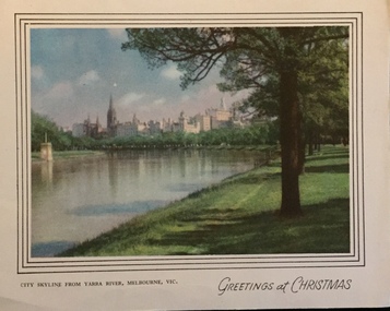
Card, Greetings at Christmas - City skyline from Yarra River Melbourne, 1955-65
... Greetings at Christmas - City skyline from Yarra River... as a greeting card Greetings at Christmas - City skyline from Yarra ...An item from an outstanding and diverse collection, assembled by members of the Christian and Washfold families of Kew.Colour print used as a greeting cardpostcards -- melbourne, christian-washfold collection -
 Kew Historical Society Inc
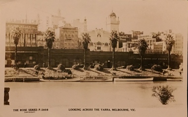
Postcard, Rose Stereograph Company, Looking across the Yarra River, Melbourne, Vic, 1935
... and publications donated to the collection in May 2021. yarra river city ...One of a number of 'real photo' and commercial postcards created by or owned by members of the Christian and Washfold families of Kew. The postcards are part of a larger collection of photographs, postcards and publications donated to the collection in May 2021.Monochrome postcard of view of the north bank of the Yarra River between Flinders and Russell Streets. Scene shows palm trees, boats and stores under embankmentThe Rose Series P. 2808yarra river, city of melbourne, postcards -- melbourne, christian-washfold collection -
 Kew Historical Society Inc
Map, MMBW, MMBW Town of Kew, 1910-21
The Melbourne and Metropolitan Board of Works (MMBW) was established by an act of the Victorian Parliament in 1890 to prepare for and to implement a sewerage and water reticulation system across what was then inner Melbourne, its surrounding and middle distance suburbs, including Kew. The MMBW was disbanded in 1991.The map collection of the Kew Historical Society has at its core the historic maps assembled and originally stored in the City Engineer's Department of the City of Kew. These include maps in a number of scales. The vast majority of maps were produced by the MMBW in the first two decades of the twentieth century, and are solid working maps, backed by linen for durability. These maps are historically significant to Kew, the City of Boroondara and to the history of the development of state utilities in Victoria. A number of the Kew maps have additional details added by former municipal officers, including the levels reached by various floods. As these were working documents, information was added to them long after the period of their initial production and distribution.Early map of the Town of Kew, created after 1910, at a scale 440 ft to 1 inch. The 'assembled' map by the City of Kew Engineer's Department includes scaled down copies of The Melbourne and Metropolitan Board of Works maps, Nos. 39, 40, 64, 65, 66, 67, 68, and 117. The map covers the entirety of the Town of Kew, bordered on its north and west by the River Yarra, by Burke Road in the East and Barkers Road in the south. The map shows the extent of urban development by that time, prominent institutions and the outlines of built structures in the municipality. TOWN OF KEW / SCALE 400 FEET TO 1 INCHmelbourne & metropolitan board of works, mmbw maps, mmbw plans, town of kew, cartography -
 Kew Historical Society Inc
Map, MMBW, River Yarra Beautification Schemes, c.1913
The Melbourne and Metropolitan Board of Works (MMBW) was established by an act of the Victorian Parliament in 1890 to prepare for and to implement a sewerage and water reticulation system across what was then inner Melbourne, its surrounding and middle distance suburbs, including Kew. The MMBW was disbanded in 1991.The map collection of the Kew Historical Society has at its core the historic maps assembled and originally stored in the City Engineer's Department of the City of Kew. These include maps in a number of scales. The vast majority of maps were produced by the MMBW in the first two decades of the twentieth century, and are solid working maps, backed by linen for durability. These maps are historically significant to Kew, the City of Boroondara and to the history of the development of state utilities in Victoria. A number of the Kew maps have additional details added by former municipal officers, including the levels reached by various floods. As these were working documents, information was added to them long after the period of their initial production and distribution.Map of the City of Kew showing part of the River Yarra Beautification Schemes. The map shows development to date and the flood levels reached in 1923 and 1924. This map may have been adapted from an earlier map, as most development in central Kew and Studley Park had occurred by this date yet numerous streets are not represented. Public buildings and institutions are clearly represented and named on the map as are significant public transport infrastructure (eg the Outer Circle railway).MELBOURNE AND METROPOLITAN BOARD OF WORKS / RIVER YARRA BEAUTIFICATION SCHEMES / SCHEME / SCALE 10 CHAINS TO AN INCHmelbourne & metropolitan board of works, mmbw maps, mmbw plans, city of kew, flood levels -- kew (vic.), cartography -
 Kew Historical Society Inc
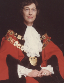
Photograph - Cr Jill O'Brien, Mayor of Kew 1983-84
Born in Bendigo and trained as a nurse in the 1950s, Sonia Jill O’Brien devoted a lifetime to social and environmental issues at both the state and local level. From her work in the 1960s with the Family Planning Association of Victoria, of which she was a founding member, through to the 1990s as a member of the Ethics Committee of the Department of Health, she supported efforts to improve women’s health and reproductive rights. At the local level she was most active on committees that worked to save the natural and built environment. The Power-line Action Group, the Studley Park Conservation Society, and the Yarra Bend Park Trust all benefitted from her indefatigable endeavours as well her vision. In 1980, Jill O’Brien successfully stood for the Kew City Council and served as Mayor in 1983 and 1984. With an eye to preserving the past as well as guarding the future, she had the Mayoral robes restored and in 1980 and 1981 was president of the Kew Historical Society. The preservation and restoration of Villa Alba in Walmer Street owes much to her determined efforts throughout the 1980s. On Council, she chaired a number of committees involved in the saving of the Kew River Parklands from the proposed transmission line of the SEC. To this end, she was the Council representative on the Merri Yarra Municipal Protection Committee.Rare colour photograph, used as the official mayoral portrait of Cr Jill O'Brien.Formal civic portrait of Cr Jill O'Brien in red mayoral robes wearing lace jabot and cuffs. The portrait is part of the larger Jill O'Brien Collection donated by her daughters.cr jill o'brien, city of kew -- mayors, mayoral portraits -- city of kew -
 Kew Historical Society Inc
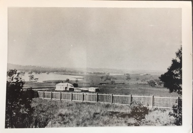
Photograph - Yarra in Flood - Belford & Kilby Farms, 1903
The Yarra Valley in what was previously called North Kew, but is now East Kew, was frequently subjected to flooding. Apart from some development on higher ground, the City of Kew regularly introduced restrictions on development and the building of housing in the area because of flood levels. Panoramic photographic positive of North Kew where the Belford and Kilby Farms were located on the south side of the Yarra River. This photo is a copy of the original photo in the collection.floods -- yarra -- 1903, kew golf course, greenacres golf course -
 Kew Historical Society Inc
Photograph - Kew Main Drain, 1984
'Kew, Kew East, Balwyn & Balwyn North are located approximately 7km north east of Melbourne. Four main stormwater drains service the area flowing from south to north. Three of the drains: Deepdene Drain; Balwyn Drain & Glass Creek converge in Kew East just west of Burke Road at Kew High School before discharging into the Yarra River. The fourth drain, Kew Main Drain connects directly with the Yarra River to the West of Glass Creek.' The Kew Main Drain is a barrel drain that was created in the 1930s, and follows the route of the former Connor's Creek from the vicinity of Genazzano FCJ College to the Yarra River in East KewImportant and verifiable evidence of the construction methods used by the Melbourne & Metropolitan Board of Works in building the Kew Main Drain, before its reconstruction in c.1985.Original print colour positive photograph of the Kew Main Drain, provided on 14/12.84 to the Chief Engineer of the City of Kew, Ian Poulter, by the Supervising Engineer (Works), Southern and Eastern Drainage, Melbourne & Metropolitan Board of Works. The record includes an image of the reverse as well as the donation document from the MMBW."A84/1855-9 / 750mm council drain looking D/S [down stream] and across Parkhill Road. To be replaced with 1200 mm R.C.P. [reinforced concrete pipe] as part of MMBW Kew Main Drain reconstruction works"kew main drain, stormwater drains -- kew (vic.), connor's creek -- kew (vic.) -
 Kew Historical Society Inc
Photograph - Kew Main Drain, 1984
'Kew, Kew East, Balwyn & Balwyn North are located approximately 7km north east of Melbourne. Four main stormwater drains service the area flowing from south to north. Three of the drains: Deepdene Drain; Balwyn Drain & Glass Creek converge in Kew East just west of Burke Road at Kew High School before discharging into the Yarra River. The fourth drain, Kew Main Drain connects directly with the Yarra River to the West of Glass Creek.' The Kew Main Drain is a barrel drain that was created in the 1930s, and follows the route of the former Connor's Creek from the vicinity of Genazzano FCJ College to the Yarra River in East KewImportant and verifiable evidence of the construction methods used by the Melbourne & Metropolitan Board of Works in building the Kew Main Drain, before its reconstruction in c.1985.Original print colour positive photograph of the Kew Main Drain, provided on 14/12.84 to the Chief Engineer of the City of Kew, Ian Poulter, by the Supervising Engineer (Works), Southern and Eastern Drainage, Melbourne & Metropolitan Board of Works. The record includes an image of the reverse as well as the donation document from the MMBW."A84/1855-10 / 750mm council drain looking U/S [up stream] from Parkhill Road, Kew."kew main drain, stormwater drains -- kew (vic.), connor's creek -- kew (vic.) -
 Queen Victoria Women's Centre
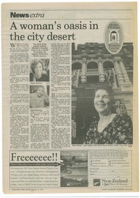
Newspaper Excerpt, A woman's oasis in the city desert, 17 February 1997
News paper article. News extra. Melbourne Yarra Leader page 8. Three black and white photographs of women on page. QVWC original logo on top right of page. official events, openings (events), historic buildings -
 City of Warrnambool Rowing Club
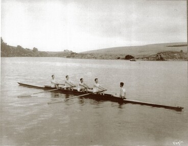
Photograph
The photograph is of the 1925 Warrnambool Rowing Club Lightweight four- they raced at the clubs annual Boxing Day Regatta. H Sherriff was stroke J MacNamara (3 seat) C Earls (2 seat) L Halliwell (bow), T Fary was cox. The Regatta that year had three events and the other usual aquatic events were cancelled due to poor weather. Mr W. A. Hope was regatta secretary. It is recorded on page 109 of the 1914-35 minute book that 'Mr. Meckin, the president, said he had much pleasure in moving a motion of long salutation to the light weight four in recognition of the fine performance they put in at the Yarra Yarra and Albert Park Regattas...Mr. Hope seconded and added...credit to the crew..a fine lesson to some of the older members in perseverance..'Black and white photograph of a Warrnambool Rowing Club crew of 5 in a rowing boat on the Hopkins River, Warrnambool. Taken in 1925. Under the photograph is the name of the crew and year it was taken: Lightweight fours 1925 H Sherriff stroke J MacNamara C Earls L Halliwell bow T Fary coxrowing, warrnambool rowing club, hopkins river, city of warrnambool rowing club -
 City of Warrnambool Rowing Club
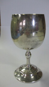
Trophy
Regatta trophyTwo - Silver colored trophy cup.Front: Novice Event Upper Yarra Regatta Warrnambool D. Brodwick. One the back: Winning Crew Stroke: E. McLaren 3. G. Hassell 2. D. McDougall Bow: D. Brodwick Cox: H. Sherlockwarrnambool, warrnambool rowing club, city of warrnambool rowing club, upper yarra regatta -
 Williamstown Botanic Gardens- Hobsons Bay City Council
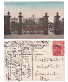
Postcard - Williamstown Botanic Gardens, c1900-1910
The original postcards in this series (2013.002 to 2013.018) were generously loaned to Williamstown Botanic Gardens by a private collector for copying. The cast iron gates (manufactured in Glasgow) introduced at the North West entrance in 1907. The gates were purchased from ‘Fairlie” corner of Acland and Anderson Streets, South Yarra at the cost of 72 pounds and cost 60 pounds to install. They had originally cost the owners of ‘Fairlie’ 1200 pounds. The postcards are evidence of the interest the gardens held as a subject for postcard publishers. The text and images provide a snapshot into fashions, social interests and concerns of the time. The professionally produced images provide a pictorial history of Gardens including changing planting styles, various structures and features of the Gardens eg the aviary, cannons, the fountain, the second Curator’s Lodge and gates. The images offer an opportunity to compare garden vistas with the present day. The image in this postcard shows the gates intact and as installed in 1907. The current layout of this area still reflects the change of design, which followed the 1907 removal of the first gardener's residence and the subsequent re-organisation of this quarter of the gardens. This postcard is evidence of the placement of one of the cannons relocated from Fort Gellibrand in 1906. They were removed from the Gardens in the 1960s. These same cannons remain a feature on the Williamstown waterfront in 2013. Postcard in colour of main entrance gates, one of the cannons can be seen through the pedestrian gate on the right. The gates are cast iron, double carriage gates with single pedestrian gates on either side and supported by four cast iron posts with ornamental finials. Front: ‘Gates, Williamstown Gardens’. Reverse: Vertical on left side of card ‘O Rippon Se..es’ [name of the publisher is unclear]. Top centre of card: ‘POST [logo of card publisher] CARD’. Left side of card: ‘This space may be used for communication.’ Right side of card: ‘for Address only.’ Left bottom corner: ‘Printed in ……..’ [name unclear]. Top right hand corner: a red one penny Tasmanian stamp with a depiction of Mount Wellington. Bottom right corner in pencil ‘1908’ believed to be inserted by the vendor. The card is dated 15.5.10 by the sender. It is addressed to Miss E G Holford of Launceston, Tasmania and sent by Addie.postcard, gardens, post-card, williamstown-botanic-gardens, hobsons-bay-city-council, entrance gates, entrance-gates, cast iron, finials, cannon, 1910, 1908, tasmania, tasmanian-stamp -
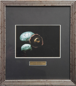 Federation University Art Collection
Photograph, Steinfort, Jessie, 'Mushrooms' by Jessie Steinfort, 1998
Jessie STEINFORT Steinfort was Studied Graphic Design at the University of Ballarat (later Federation University) After 12 years of working in design studios and advertising agencies, Steinfort is now a Senior Designer at Ogilvy Melbourne. And previously, he has been responsible for work on BMW & Mini, Carlton Football club, Melbourne Convention and Exhibition Centre, Melbourne Food & Wine Festival, AAMI, Yarra Valley Water, and Arts Centre Melbourne. From 2008 to 2011 Steinfort was lead designer and front-end web developer at clickDM (now HARDWIRE). Where he worked with such clients as HOSTPLUS, GSK, UniSuper and Swann Insurance. From 2000 to 2008 Steinfort was a designer at Mediation Communications working on print and interactive projects for; City of Melbourne, City of Greater Geelong, City of Port Phillip, Mentor Education, and ACMA. This item is part of the Federation University Art Collection. The Art Collection features over 2000 works and was listed as a 'Ballarat Treasure' in 2007. Framed photograph of three mushrooms in a black background. This work was won the 1998 Student Acquisition Award. If you can provide information on this artist or artwork please use the email link below. photography, foto, mushrooms, food, close up, macro, colour, photo, jessie steinfort, alumni, available -
 University of Melbourne, Burnley Campus Archives
Plan, Burnley Gardens. City of Richmond. Parish of Jika Jika - County of Bourke, 1927
Part-coloured plan showing drainage, sewerage drains, taps and waterstops. Area bounded by Swan St. To N, Yarra River on E and Richmond Park on SW side. Contour lines of orchard depicted, laying pens and yards. Coloured area depicts pavilion with surrounding garden and paths layout pencilled in. Photo-Lithograph by Dept. of Lands & Survey, Melbourne by W. Butsonsewerage, drainage, lithograph, pavilion -
 University of Melbourne, Burnley Campus Archives
Plan, Burnley Gardens. City of Richmond. Parish of Jika Jika - County of Bourke, 1927
Plan showing Burnley Gardens - bounded by Swan St to N, Yarra River to E, Richmond Park on S and W side. Photo-lithographed at Dept. of Lands & Survey by W.J. Butson. Plan shows old orchard, fowl sheds, coops and yards, milking shed, silo, nursery, glasshouse, fattening pens, dairy, garden, orchards area in S.W. area.burnley gardens, orchards, sheds, nursery -
University of Melbourne, Burnley Campus Archives
Plan, Burnley Gardens. City of Richmond. Parish of Jika Jika - County of Bourke, 1927
Plan showing Burnley Gardens - bounded by Swan St to N, Yarra River to E, Richmond Park on S and W side. Photo-lithographed at Dept of Lands & Survey by W.J. Butson. Plan shows old orchard, fowl sheds, coops and yards, milking shed, silo,nursery, glasshouse, fattening pens, gardens and orchards area in S.W. corner.burnley gardens, orchards, sheds, nursery -
University of Melbourne, Burnley Campus Archives
Newspaper - Newspaper Cutting, Girl's Career in Horticulture and Gardening School is Popular
girls' careers, careers, female students, landscape gardening, city park, judith henry, 1948 student group, burnley school of horticulture, 1948 graduates -
University of Melbourne, Burnley Campus Archives
Flyer, The University of Melbourne et al, Climate Adaptation Along the Birrarung: A Day For Learning, 30.11.2023
... of melbourne, Birrarung Council, Yarra Riverkeeper and Merri-bek City... Mooroop yarra riverkeeper merri-bek city council Design ...climate adaptation, birrarung, ballerrt mooroop, yarra riverkeeper, merri-bek city council -
University of Melbourne, Burnley Campus Archives
Flyer, Climate Adaptation Along the Birrarung: A Day for Learning
... of Melbourne, Birrarung Council, Yarra Riverkeeper and Merri-bek City... birrarung council yarra riverkeeper merri-bek city council Design ...exhibition, yarra river, birrarung, ballerrt mooroop, wurrundjerri country, university of melbourne, birrarung council, yarra riverkeeper, merri-bek city council -
University of Melbourne, Burnley Campus Archives
Postcard, The University of Melbourne, Growing Greener Cities
research, university of melbourne -
University of Melbourne, Burnley Campus Archives
Document - Course Information, The University of Melbourne et al, Australian School of Urban Forestry, 2018
professional development forestry, urban forestry, course -
University of Melbourne, Burnley Campus Archives
Map, City of Ringwood, c.1895
(1) Coloured map with Reserves, Council (other than Reserves) and Schools by City Engineer, c1985. (2) 10 copies. (3) Tracing paper copy.ringwood, gardens -
University of Melbourne, Burnley Campus Archives
Plan, City of Keilor, Delahey Recreational Reserve, Tennis Complex, Goldsmith Ave, 1994
(1) Planting Plan, coloured, dated 19.08.1994, Sheet 3 of 3. by J.Coghill. Scale 1:100. (2) Sheet 2 of 3.keilor, delahey recreational reserve, , j. coghill, planting plan -
University of Melbourne, Burnley Campus Archives
Plan, Kirsten Strutt, Central Gardens Hawthorn, 1996
Plans by Kirsten Strutt (student) for Hawthorn City Council. Scale 1:500. (1) Site Analysis September 1986. (2) Tree Survey October 1986 Drawing No 2.kirsten strutt, hawthorn, gardens, central gardens hawthorn -
University of Melbourne, Burnley Campus Archives
Plan, Kate Blood, City of Werribee Proposal for a Monument to Mark the Proclamation of Werribee as a City, 1987
Coloured elevation by Kate Blood dated 16.04.1987kate blood, werribee -
University of Melbourne, Burnley Campus Archives
Plan, [Historical Maps of Richmond Park], 1862-2000
(1) Proposed reserve for Horticultural & Experimental Garden in the Survey paddock Richmond. R.19A (1865). Shows Swan Street Extension. Gazettals 1877, 1887. (2) As (1). Half of map only Annotation by A. Purchas, 9 October, 1862. (3) Plan of Richmond park. A.L. Martin Authorised Surveyor, 31st August, 1872. [Dept. of lands & Survey Melbourne, J. Noone, 6th September 1872.] Map in 4 sheets. (4) Richmond Park. Surveyed by Geo. Black, Authorised Surveyor 13.8.91 (2 copies). (5) [Richmond Park] Shows road alignments gazetted 1871 & 1881 (part copy only - Neg. 18375). (6) City of Richmond Parish of Jika Jika County of Bourke. Department of lands & Survey, 1919 (annotations i.e. Melb. City Link, Amrad, etc. to 1994.) (7) Burnley gardens, 2000. Produced by P. Tulk, Institute of Land & Food Resources, Burnley College, 2000 (re area proposed for heritage listing.)richmond park, survey paddock -
University of Melbourne, Burnley Campus Archives
Map, Plan of Early Melbourne Showing Original Crown Allotments, c. 1852
Copy of 'Map of the City of Melbourne, and its Extension, together with Collingwood, Richmond, Hawthorne, the Emerald Hill, and a portion of Prahran Compiled from the Government Plans and Private Survey by William Green.' (2 copies, one enlarged)melbourne, william green, richmond, hawthorne, collingwood -
 University of Melbourne, Burnley Campus Archives
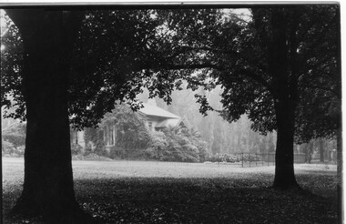
Photograph - Black and white print, Sinclair's Cottage, Fitzroy Gardens, Unknown
Georgina Whitehead-who is producing a book on public gardens of Melbourne City Council - believes it to be Sinclair's Cottage in the Fitzroy Gardens. Note by T.H. Kneen 19 November 1991, "subject of an excursion."Black and white photograph. View through canopy of trees to house in background.trees, georgina whitehead, sinclair's cottage, fitzroy gardens, excursion -
 University of Melbourne, Burnley Campus Archives
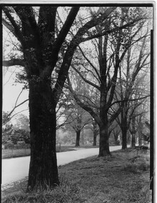
Photograph - Black and white print, Fitzroy Gardens, Unknown
Georgina Whitehead - who is producing a book on public gardens of Melbourne City Council - believes it to be Sinclair's Cottage in the Fitzroy Gardens. Note by T.H. Kneen 19 November 1991, "subject of an excursion."Black and white photograph. Avenue of Elm trees in parkland, probably Fitzroy Gardens.trees, parks, georgina whitehead, sinclair's cottage, excursion, elms, fitzroy gardens -
University of Melbourne, Burnley Campus Archives
Photograph - Black and white print, Floral Parade and Pageant, 1934
(1) Pamphlet advertising a Floral Pageant organised for the Victoria-Melbourne 1934-1935 Centenary to be held in November 1934. (2) Photograph of a Floral Float, "City of Footscray."floral pageant, melbourne, centenary, floral float, city of footscray, 1934, 1935