Showing 15974 items
matching kiewa-valley
-
 Kiewa Valley Historical Society
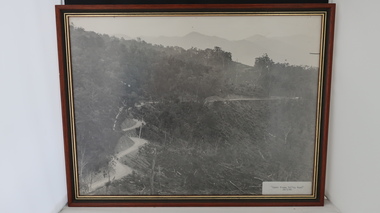
Set of 3 framed photographs - Kiewa Hydro Electric Scheme
Official photos - Kiewa Hydro Electric Scheme constructed by the State Electricity Commission of VictoriaOfficial photo of the KHES in the Kiewa Valley1. Upper Kiewa Valley Road 28th March 1940 2. Upper Kiewa Valley Road 23rd August 1940 3. Construction of the Buttresses of Junction Dam Wall. 23rd March 1942 Each black and white photo is labelled with a date.khes, secv -
 Greensborough Historical Society
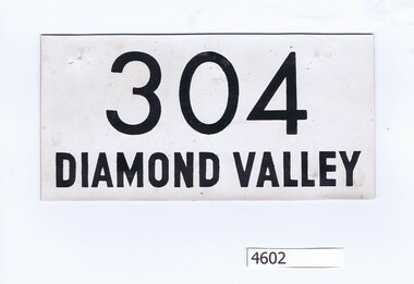
Label, Competitor's number 304, 1967_
Competitor's bib number for Diamond Valley Little Athletics, Opening Day 1967.Printed competitor's bib label printed in black on white plasticised cloth304 Diamond Valley -
 Kiewa Valley Historical Society
Photos, Postcards - Kiewa Valley
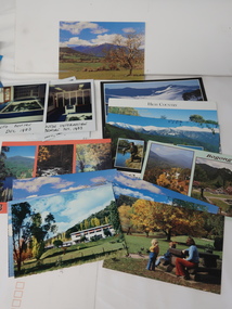
Mt Beauty township, at the head of the Kiewa Valley, is situated at the foot of Mt Bogong. The town was established by the State Electricity Commission of Victoria during the construction of the Kiewa Hydro Electric Scheme on the High Plains.Mt Beauty is a popular tourist resort. The main highway from Mt Beauty to the Bogong High Plains is most picturesque throughout the year. During the winter months, Falls Creek provides access to Falls Creek Ski Village for snow sports. Tawonga, 6.5 km north of Mt Beauty, is famed for its trout fishing and camping on the Kiewa River. Deciduous trees make a show of colour during Autumn. The postcards are of historical value showing photos taken at an earlier time.The postcards can be compared to the attractions of the time as they do not include cycling (mountain bikes and road bikes), snow boarding, gliding and paragliding. Advertising for tourism has also changed as attractions are now available on-line. 1. 9 Coloured Photos of Bogong (5) and Visitors Information Centre display (4) 2. Two fold out coloured sets of postcards "Mt Beauty and the Kiewa Scheme", "Mt. Beauty Victoria" 3. x10 Coloured postcards Mt Beauty, Kiewa Valley, Bogong 4. x6 Coloured postcards High Country and Bogong Villagepostcards kiewa valley -
 Kiewa Valley Historical Society
Photograph - Folder of Photographs (KVHS 1150 A - F) – Photocopied set of black and white photographs from the display folder (pages 1 - 8) put together by KVHS to document life on the Kiewa Valley Hydro-electric Scheme
Although the Kiewa Hydro-Electric Scheme was first proposed in 1911, construction did not commence until 1938. As part of the push to cut electricity costs and diversify supply, the Victorian Government (circa 1930) initiated the conversion from primarily brown coal supply to hydro – electricity. Field investigations during the 1940’s resulted in a new proposal for a scheme that had more than double the capacity of the 1938 scheme. The Kiewa Hydroelectric Scheme became the largest scheme of its kind in the State Of Victoria and the second largest scheme in Australia. The number of personnel involved in the planning and construction of the scheme increased dramatically. During the late 1940’s, most activity centred around the construction of the West Kiewa Power Station, Rocky Valley Reservoir, McKay Creek Power Station and the Bogong Creek Aqueduct.A common thread across all the larger hydro scheme constructions was the need for workers, both qualified and unqualified who came from around the world seeking a new life for themselves and their families. New accommodation and facilities were required for the army of workers engaged in construction in often remote and wild areas. The SEC had a high demand for timber, and set up the first of a number of sawmills at Bogong Creek in 1939 and set up the first hardwood logging in the headwaters of the Kiewa River. These new ‘towns’ such as Mt Beauty and Bogong, survived, serving the needs of operational personnel and their families, and expanding with growth of new industries. Mount Beauty, and to a lesser extent Bogong, are among these places. Large A3 size spiral bound display folder containing 21 of 58 pages of photocopied black and white photographs of various aspects of the early days of the Kiewa Valley Hydro-electric scheme including equipment, various work sites and photographs of workers and their families. 1-Front page; 2-Security gate at Mt Beauty Camp; 3-Channel 1 on East Kiewa River; 4-Junction Dam – Diversion Tunnel Inlet; 5-Sawmill; 6- Homan’s Gap Sawmill; 7 Junction Dam: 8-Homan Dam Site-Diamond Drilling on River Buttress; 9- Homan Dam Site View Upstream 10-Homan Dam Investigation Camp 1-Windsor & Newton Visual Diary 60 sheet (120 pages) 11’ x 14’ 280 x 356mm 110 GSM Acid Free Drawing Paper 2-1940-Security Gate on Mt Beauty side of Kiewa River bridge. Part of old Mt Beauty camp and mess in background 3- STATE ELECTRICITY COMMISSION OF VICTORIA Date; 11.3.40 Time: 10.30am No K35 Kiewa Hydro Electric Works. Diverting East Kiewa River into Channel Page number 1 4-STATE ELECTRICITY COMMISSION OF VICTORIA Date: 5.4.40 Time: Noon No K58 Kiewa Hydro Electric Works. Junction Dam – Diversion Tunnel Inlet – Normal Flow Page number 2 5- STATE ELECTRICITY COMMISSION OF VICTORIA Date: 19.8.42 Time: 2.30pm No K883 Kiewa Hydro Electric Works. Sawmill – General View Page number 3 6- STATE ELECTRICITY COMMISSION OF VICTORIA Date: 12.1.42 Time: 2.00pm No K540 Kiewa Hydro Electric Works. Homan’s Gap Sawmill – General View Page number 4 7- STATE ELECTRICITY COMMISSION OF VICTORIA Date: 12.1.42 Time: 2.00pm No K540 Kiewa Hydro Electric Works. Junction Dam – General View looking upstream Page number 5 8- STATE ELECTRICITY COMMISSION OF VICTORIA Date: 16.11.45 Time: 10.32amm No K52153 Kiewa Hydro Electric Works Homan Dam Site – Diamond Drilling on River Buttress Page number 6 9-STATE ELECTRICITY COMMISSION OF VICTORIA Date: 15.1.45 Time: 4.10pm No K1781 Kiewa Hydro Electric Works Homan Dam Site – View Upstream Page number 7 10- STATE ELECTRICITY COMMISSION OF VICTORIA Date: 15.1.45 Time: 4.10pm No K1781 Kiewa Hydro Electric Works Homan Dam Investigation Camp 1944 – 1945 Page number 8 secv; kiewa hydro electric scheme; mt beauty; bogong; construction work; -
 Kiewa Valley Historical Society
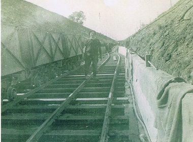
Photograph KHS Rail, Kiewa Hydroelectric Scheme Railway, Circa1940s
This photograph shows part of the railway constructed and used for the removal of soil and rocks from the tunnels bored out of the mountains for the pipeline servicing the Hydro Electricity power stations in the Kiewa Hydroelectric Scheme. This photo details an era when there were 4,000 construction workers located in two main accommodation camps, Mount Beauty (the larger one) and Bogong village. These accommodation sites were constructed and maintained as a secured or gated residential area with access only available by a special pass authorised by the Kiewa Hydroelectric Scheme. All the power used by the rail system was from electric motors connected to batteries. Overhead power poles seen on either side of the embankment details that electricity from the Scheme was in use. This use was cleaner and more environmentally friendly than the coal still used by large locomotives from city to country railways. The worker shown is not however wearing protective head and hand coverings. This is also an era where there was a lack of health and safety legislation covering workers in dangerous working conditions.Scanned photo of original black and white photo on Kodak XtraLife II paper. Picture is of a section of railway track servicing the tunnels of the Hydroelectric scheme during the 1940s - 1950sOn back of photo "Kodak XtraLife II paper"railway in kiewa electric scheme, tunneling -
 Kiewa Valley Historical Society
Postcard - Rocky Valley - Circa 1950, 1950
This postcard was produced in the 1950's for the tourist trade in the Kiewa Valley and Alpine region. It encompasses the period when the State of Victoria was pressured by the ever increasing demand by industry and its population for electricity supplies. Hydro electricity was seen as an untapped natural resource to quench this demand. The Victorian Alps and the rivers flowing into its valleys was ideal for the construction of the Kiewa Hydro Electricity Scheme. The late 1940's saw the development of this scheme and the changing of sections of alpine landscape is covered by this and other postcards/pictures (tourists, construction workers, and established rural populations). This period in time was before the established wildlife and forest/nature groups became political activist who changed legislative acts to protect the environment.This rural region (Kiewa Valley/alpine plains) was at most only significant to a smaller group of winter sports, summer hikers/horse riders and rural farmers/graziers. The numbers of tourists and the increase in the local resident population was boosted by the construction of the Hydro Electricity Scheme. This influx to the regional population resulted in a corresponding diversity in services and brought about an environment that responded to a growing level of tourists and thereby permitting this industry to grow more rapidly than it would have naturally. This postcard details an attraction to the "cleaner" method of providing electricity. This postcard was purchased in 1950 by a surveyor at Landford's Gap.This black and white photograph is from a Valentine's V2 Argus postcard. It is on a 200g/m paper density one side gloss. See also KVHS 0480 (A) to (L) for similar postcards. "ROCKY VALLEY FROM BOGONG HIGH PLAINS KIEWA HYDRO-ELECTRIC PROJECT" "V1"kiewa valley tourism, victorian alps, alternate energy supplies, alpine population growth, rocky valley, secv -
 Greensborough Historical Society
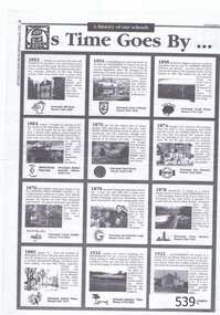
Newspaper Clipping, Diamond Valley Leader, As time goes by; a history of our schools, 27/08/1997
This supplement to the Diamond Valley Leader August 27 1997, lists details of the foundation and history of all schools in the Diamond Valley/Banyule area.Information regarding the foundation of primary and secondary schools in the area. includes state, catholic and private schools.5 pages copied from Diamond Valley Leader 1997.heidelberg, ivanhoe, schools, banyule, greensborough -
 Falls Creek Historical Society
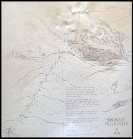
Map - Sun Valley, Falls Creek, 1966
This hand drawn map shows the Gully Chair, Summit Tow and the Village Tow. It also highlights the Nursery Poma. Several buildings can be seen along with the Visitor Centre in the Gully carpark, Skyline can can be seen adjacent to the Gully Chair. The Sun Valley T-Bar was designed by Ron McCallum and began operation in 1967. It had a length of 826 metres and an elevation of approximately 200 metres. In 1989 the Sun Valley T-Bar was replaced by the Scott Quad. Ron McCallum was a founder of Alpine Developments. It appears that his first lift was the Skyline portable tow at Falls Creek in 1954. As an engineer, he went on to build about 20 chairlifts and T-bars in the 1960s and early 1970s including at least five at Falls Creek. This map is significant because it shows plans for the development of a major tow at Falls Creek in the 1960s.A framed black and white concept map for the proposed new lift in Sun Valley, Falls Creek.sun valley tow, ron mccallum, falls creek tows -
 Kiewa Valley Historical Society
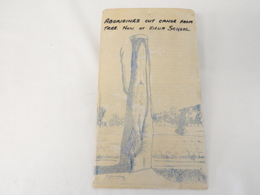
Sketch Tree Bark, Aboriginal - bark removed from tree
This sketch of a tree whose bark was cut, by aboriginal craftsmen, to produce a canoe for fishing in the rivers running through the Kiewa Valley either before or just after the 1800's. The tree trunk depicted in the sketch would have been used at the beginning of European settlement in the Kiewa Valley or just before contact was made.As this sketch was of a tree found along the Kiewa River it indicates that Aborigines lived by the river. This sketch depicts the usage of tree bark by the Aboriginal fisher person in crafting a canoe to cross rivers and to fish in the deeper sections of the river course.This freehand sketch detailing the outline of bark removed to provide a canoe is in ink portraying a tree trunk with one branch which has a plaque in front a gravel section to the right and open fields in the mid background and scattered trees on a hill slope in the far background. The sketch is on thick cardboard with a plastic protective cover over it (fastened on the flip side). It is a sketch of the tree now exhibited at the Kiewa Consolidated School.Written in black ink on the top section (heading) "ABORIGINES CUT CANOE FROM TREE. NOW AT KIEWA SCHOOL"crafted canoe, aboriginal craftsmanship, tree usage, early aboriginal craftsmen, kiewa river. kiewa consolidated school -
 Tatura Irrigation & Wartime Camps Museum
Folio, Goulburn Valley CWA West Group 1954-2004, 2004
A record of events of Goulburn Valley West Group CWA Golden Jubilee 1954-2004.A4 size, plastic cover, green spine, green lettering, CWA badge, Goulburn Valley West Banner on front, sketch map of district. 73 pages.cwa, goulburn valley west cwa, cwa golden jubilee -
 Carlton Football Club
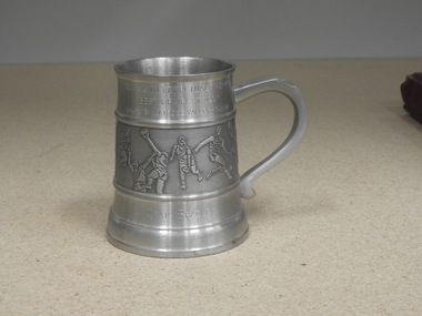
Pewter Mug, TOM ALVIN PERPETUAL TROPHY Presented Latrobe Valley Hyundai, 1997
Yarra Valley Hyundai presentation to Carlton B&F winner 1997A perpetual Trophy presented by a major sponsor Hyundai in the guise of "TOM ALVIN PERPETUAL TROPHY". In 1997 it was presented to Craig Bradley Carlton Best & Fairest winner 1997. Career : 1986 - 2002 Debut : Round 1, 1986 vs Hawthorn, aged 22 years, 159 days Carlton Player No. 931 Games : 375 Goals : 247 Last Game : Round 19, 2002 vs Port Adelaide, aged 38 years, 291 days Guernsey No. 21 Height : 182 cm (5 ft. 11 in.) Weight : 81 kg (12 stone, 11 lbs.) DOB : 23 October, 1963 Premiership Player 1987, 1995 Carlton Legend Carlton Hall of Fame (1995) Best and Fairest 1986, 1988, 1993 All Australian 1986, 1993, 1994, 1995, 1997 Captain 1998-2002 Team of the Century: Wing International Rules Series vs Ireland : 2000, 2001 (captain), 2002 Off the field, Craig Bradley was a somewhat quiet, unassuming character who never hungered for the spotlight. But when the umpire’s whistle blew for a game of Australian football, he became a consummate professional whose outstanding ball-winning ability, accurate disposal, punishing non-stop running and longevity in the game made him one of the all-time greats. “Braddles” captained the Blues for three years, won two AFL Premierships, and picked up almost every possible honour in a stellar career that spanned 17 seasons and a record 375 games for the Carlton Football Club. He began his football journey at Pooraka in outer-suburban Adelaide, where his father was coach of the Under-19 team. Craig was a stand-out junior footballer, and in 1981 he was recruited by SANFL club Port Adelaide. At the same time, Essendon also made a big pitch for his signature. The Bombers were very intent on getting him to Windy Hill, but Bradley wasn’t then ready to make the big move interstate. Essendon redoubled their efforts after Bradley’s sensational debut year for Port Adelaide, which culminated in the Magpies’ 51-point demolition of Glenelg in the Grand Final. Playing on a wing, but roaming the length of the ground, 17 year-old Bradley was one of his team’s best. He followed up by winning Port’s Best and Fairest in 1982, before departing for England later that year, as a member of the Australian Under-19 cricket team. Cricket was Braddles’ other great sporting passion, and he would eventually play two Sheffield Shield games each for South Australia and Victoria, before giving the game away to further his football ambitions. Because of his cricketing commitments, Bradley missed most of the 1983 pre-season with Port, but it made little difference, because he had another dominant season for the Magpies and was named All Australian for the first time. Two more Port Adelaide Best and Fairests followed in 1984 and '85 – with the latter complemented by All Australian honours again. In that year of 1985, four South Australians were named as All Australians; Bradley, Stephen Kernahan, Peter Motley and John Platten – and to the chagrin and envy of every other VFL club (especially Essendon) the first three all signed to play with Carlton. In the following year that trio of stars took to VFL football like they were born to it, and a time of bubbling confidence began for the Old Dark Navy Blues. Braddles wasted little time in announcing his arrival into the upper echelons of our national game by playing in the 1986 Grand Final in his debut season at Princes Park; the same year he won his first Carlton Best and Fairest award in a tie with Wayne Johnston. The Blues lost heavily to Hawthorn on Grand Final day, but twelve months later bounced back to snatch the 1987 flag from the Hawks in Bradley’s 47th senior match. By then, he was already a budding champion whose amazing stamina was too much for almost every opponent. He simply ran his taggers into the ground, and he was as effective in the last minutes of a game as he was at the start. He won two more Carlton Best and Fairest awards in 1988 and 1993, and by the end of his superb career had been an All Australian six times. Aged 32, he picked up his second Premiership winner’s medallion in 1995 when the unstoppable Kernahan-led Blues demolished Geelong in a one-sided Grand Final, but those who thought he might retire after that triumph were right off the mark. He still had his zip, his footy smarts and his brilliant foot skills, and he had transformed himself from a purely attacking weapon into an equally-effective sweeper across half-back. And to cap off a memorable season, he became one of only a handful of players to be inducted into the Carlton Hall of Fame while still playing out their career. In 1997, at the age of 34, Bradley won the Sunday Age Footballer of the Year award. ”It’s not the end of the world when you reach 30,” he said in a blunt response to those who kept asking how long he intended going on – to his considerable annoyance. After being named All Australian yet again that year, he answered all those sorts of questions when he was appointed captain of his beloved Blues in 1998 – after the retirement of his great mate ‘Sticks’ Kernahan. Braddles led the Blues into another Grand Final in 1999, but the Wayne Carey-inspired Kangaroos proved just too good. Further indication of Craig Bradley’s enduring ability was his record in the often controversial and passionately-contested International Rules Series against Ireland. He first played for his country in 1984, and was recalled again in 2000. He was appointed captain of Australia in 2001, and played a fourth round of matches in 2002 at the age of 38 – a truly amazing achievement. In the millennium year of 2000, the honours kept rolling in for Braddles when he was included in both Carlton and Port Adelaide’s Team of the Century. In turn this raised the usual debate over why he had never won the game’s most prestigious individual award, the Brownlow Medal. The answer was apparently found when former field umpire Peter Cameron was interviewed, and he revealed that during most games, Bradley regularly back-chatted the men with the whistle. “He’s in the umpire’s ear all the time,’ said Cameron. By circumstance, Braddles wore his iconic number 21 guernsey for the last time against Port Adelaide at Princes Park in round 19, 2002. Carlton lost the match by 9 points, and Bradley suffered broken ribs and a punctured lung in a heavy collision. Even so, he was an almost unanimous choice as Best on Ground and was given three Brownlow Medal votes by the umpires. A few weeks later, Bradley’s farewell was typical of his nature. There was no big press conference, no stage-managed extravaganza. Instead, he issued a written statement through the AFL that caught everyone – including the Carlton Football Club by complete surprise. It read (in part); I have many people to thank and will do so in the coming weeks. I would however like to thank the Carlton Football Club and the Port Adelaide Football Club for many wonderful times and for their influence in helping to shape my life. To leave the game with a bit left in the tank and in good personal form makes me feel good. Since the foundation of the VFL in 1897, only three men (Michael Tuck, Kevin Bartlett and Simon Madden) have played more senior games than Craig Edwin Bradley of Carlton. A true Blue champion, he is one of only ten official Carlton Legends, and in 2006 was Carlton’s 17th inductee into the AFL Hall of Fame. In October 2006, it was announced that Bradley would return to the club for season 2007 as an assistant to senior coach Brett Ratten – a role he filled with the same intensity as he showed on the field. Bradley holds the club record for most career disposals, kicks, handballs, & Brownlow votes with totals of 8776, 5876, 2900 & 144 respectively.Pewter MugTOM ALVIN PERPETUAL TROPHY Presented Latrobe Valley Hyundai Best & Donated 1997 Craig Bradley -
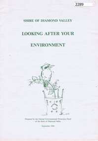 Greensborough Historical Society
Booklet, Natural Environmental Protection Panel of the Shire of Diamond Valley, Looking after your environment, 1994_09
This booklet outlines the advantages of using native plants in the garden and lists environmental groups and council services in the Shire of Diamond Valley.12 p. green text and line drawings on white paper.shire of diamond valley, native plants -
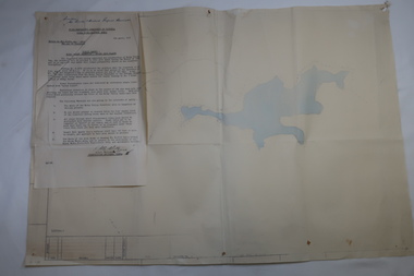 Kiewa Valley Historical Society
Plan Ref. K. 6612 with Letter attached re Public Safety in Kiewa Works Area
The SECV constructed the Kiewa Hydro Electric Scheme which included the building of Rocky Valley Dam on the Bogong High Plains near Falls Creek. H.H.C. Williams, construction engineer, Kiewa wrote to the Ski Clubs at Falls Creek outlining the dangers arising with the filling of Rocky Valley Dam. He lists 5 warnings in the interest of safety.The plan and letter provide the dates for the completion of Rocky Valley dam and its effect on the people living and working in the area including miners and ski clubs. It describes some of the features of Kiewa Works Area at the time.Plan No. K 6612 of Fall Creek showing Rocky Valley Dam's shape when it is full. Letter dated 6th April 1959 from H.H.C. Williams to Ski Clubs at Falls Creek re public safety as Rocky Valley fills. Refers to roads, transmission lines, pole lines etc in the Kiewa Works Area.Written in ink at top of letter - "Secretary / Mt Beauty and District Progress Association"rocky valley dam, falls creek ski clubs, h.h.c. williams, khes 1959, safety -
 Falls Creek Historical Society
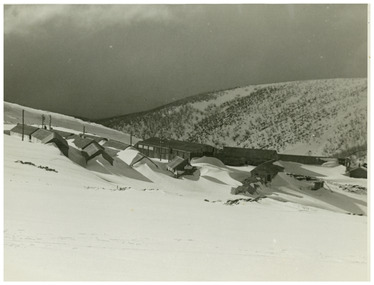
Photograph - Rocky Valley Camp
MEYER COLLECTION - FALLS CREEK PHOTOS In 1947 a determined group of like-minded State Electricity Commission (SEC) staff including Ray Meyer, the chief surveyor of the Kiewa Hydro-Electric Scheme, had a common interest that revolved around the skiing potential of the snow-covered high plains which included what is now the resort of Falls Creek. The six SEC employees, Toni St Elmo, Ray Meyer, Jack Minogue, Lloyd Dunn, Adrian Ruffenacht and Dave Gibson (together with their families) banded together to secretly build a 'hut' that was the first ski lodge at Falls Creek. Using a road built in 1930s to gain access to Falls Creek, their hut project was carried out in secret as efforts by other skiers were blocked by H.H.C. Williams – the engineer in charge of the Hydro Scheme. In 1946 Ray Meyer made a trip to the Lands Office in Melbourne. He came away with a 99-year lease on three acres that was ideally suited for a hut designed by Lloyd Dunn. Adrian Ruffenacht (Design Engineer for the KHS) had suggested where the group should build because of easy access to a spring for water. Much of the building material required was scavenged from derelict huts on the high plains. Due to the need for secrecy, the determined group worked on the hut in the evenings and weekends to avoid detection. During the building period the group had met at Echidna Rock (now known as Eagle Rock) where Skippy St Elmo announced, "This is my favourite ‘Skyline’.” And so the first lodge in the area at Falls Creek Ski Resort came into existence. With the development of the International Poma in the 1970s, the Skyline Lodge, which was sited between the ski-lift’s pole one and pole two, was demolished. However, the legacy of Ray Meyer, Toni St Elmo, Jack Minogue, Lloyd Dunn, Adrian Ruffenacht and Dave Gibson and Skyline lives on in the vibrant atmosphere of Falls Creek Resort. The MEYER COLLECTION documents developments on the Kiewa Hydro Scheme and their life at Falls Creek from the mid 1930s to 1960s.This image is significant because it documents the development of the Kiewa Hydroelectric Scheme.A black and white image of Rocky Valley Camp. Work began on the Rocky Valley Dam site in early 1947 and continued until May. It resumed in October after the winter and a camp for the accommodation of workmen was commenced at this time. Work continued in 1948 with the establishment of work facilities, including the erection of two large excavators. The Rocky Valley Dam was completed in 1959.ray meyer, blairs hut, falls creek, victorian snowfields -
 Falls Creek Historical Society
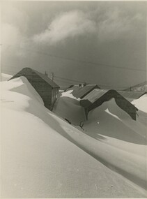
Photograph - Rocky Valley Camp
MEYER COLLECTION - FALLS CREEK PHOTOS In 1947 a determined group of like-minded State Electricity Commission (SEC) staff including Ray Meyer, the chief surveyor of the Kiewa Hydro-Electric Scheme, had a common interest that revolved around the skiing potential of the snow-covered high plains which included what is now the resort of Falls Creek. The six SEC employees, Toni St Elmo, Ray Meyer, Jack Minogue, Lloyd Dunn, Adrian Ruffenacht and Dave Gibson (together with their families) banded together to secretly build a 'hut' that was the first ski lodge at Falls Creek. Using a road built in 1930s to gain access to Falls Creek, their hut project was carried out in secret as efforts by other skiers were blocked by H.H.C. Williams – the engineer in charge of the Hydro Scheme. In 1946 Ray Meyer made a trip to the Lands Office in Melbourne. He came away with a 99-year lease on three acres that was ideally suited for a hut designed by Lloyd Dunn. Adrian Ruffenacht (Design Engineer for the KHS) had suggested where the group should build because of easy access to a spring for water. Much of the building material required was scavenged from derelict huts on the high plains. Due to the need for secrecy, the determined group worked on the hut in the evenings and weekends to avoid detection. During the building period the group had met at Echidna Rock (now known as Eagle Rock) where Skippy St Elmo announced, "This is my favourite ‘Skyline’.” And so the first lodge in the area at Falls Creek Ski Resort came into existence. With the development of the International Poma in the 1970s, the Skyline Lodge, which was sited between the ski-lift’s pole one and pole two, was demolished. However, the legacy of Ray Meyer, Toni St Elmo, Jack Minogue, Lloyd Dunn, Adrian Ruffenacht and Dave Gibson and Skyline lives on in the vibrant atmosphere of Falls Creek Resort. The MEYER COLLECTION documents developments on the Kiewa Hydro Scheme and their life at Falls Creek from the mid 1930s to 1960s.This image is significant because it depicts aspects of the development of the Kiewa Hydroelectric Scheme.A black and white image of Rocky Valley Camp. Work began on the Rocky Valley Dam site in early 1947 and continued until May. It resumed in October after the winter and a camp for the accommodation of workmen was commenced at this time. Work continued in 1948 with the establishment of work facilities, including the erection of two large excavators. The Rocky Valley Dam was completed in 1959.falls creek, victorian snowfields, rocky valley camp -
 Kiewa Valley Historical Society
Photo - Opening of the Kiewa Valley Group of the Institute of Engineers, Australia
The SECV constructed the Kiewa Hydro Electric Scheme during which time the Kiewa Valley Group was formed and joined the Institute of Engineers. Horace H. C. Williams was in charge of the the KHES.H.H.C. Williams was the engineer in charge of the KHES. Significant in that the photo is of white men in suits all holding a position of importance. This can be compared with current 'people in power'.Black and white large photo of 6 men in suits standing outside the Bogong SECV office. April 1950On the back in pencil: Mr I O'Donnell (CRB - visitor) / Mr E. D. Jo..?- Vice Chairman Kiewa V. Group / Mr D. V. Darwin? - Chairman Melb. Division / HHCW - Chairman, Kiewa V. Group / Mr..../ Mr jJrgher? - Sec. Kiewa Valley Group Note: HHCWh.h.c. williams, kvhs, institute of engineers -
 Kiewa Valley Historical Society
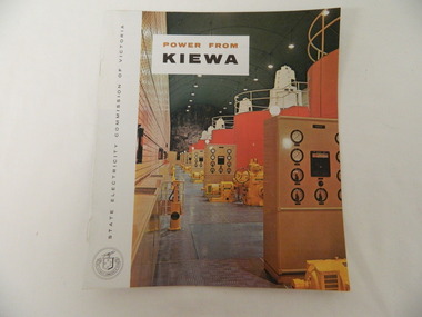
Booklet - S.E.C.V. x2, Power from Kiewa
The State Electricity Commission of Victoria constructed the Kiewa Hydro Electric Scheme. Their public relations employees published booklets to promote the Scheme and the area. In this booklet there are photos of some of the major work constructions with an explanation of how they work and their purpose, a map of the Scheme and an article and photos of tourist facilities and activities that are available.This booklet promotes the Kiewa Hydro Electric Scheme and tourism indicating that tourism was recognised as a new industry for the area. The photos give a pictorial history of the area eg. skiing using the Summit T-bar lift and includes the facilities available at the time. The explanation of the Kiewa Hydro Electric Scheme is a basic resource for students interested in Hydro power.Slim booklet with photo of McKay Creek Power Station on the front cover and the title in brown and black at the top. Printed along the spine is State Electricity Commission of Victoria.state electricity commission of victoria. kiewa hydro electric scheme. tourism. t-bar ski tow. falls creek -
 Kiewa Valley Historical Society
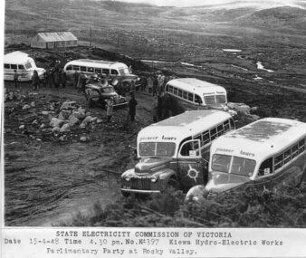
Photograph - Parlimentary Party visiting Rocky Valley Dam site, 15-4-1948
This photograph was taken during construction of the Rocky Valley Dam and wall. Work was commenced in early 1947 but had to be suspended during winter and then resumed in October. Work continued in 1948 with the establishment of work facilities and, at the dam site, the river was diverted through a temporary pipeline. Rocky Valley and associated spillway and outlet works were completed in 1959.A pictorial record of the construction of the rock and earth filled dam wall at Rocky Valley. Shows the extent of the project undertaken and the level of importance of the project as indicated by the large representation at the parliamentary party visit on 15/4/48.Photocopy of black and white photograph of parliamentary party visiting Rocky Valley Dam site 15/04/1948Typed on the bottom of photocopy - State Electricity Commission of Victoria. Date: 15-4-48 Time: 4.30pm No: K4397. Kiewa Hydro-Electric works. Parlimentary Party at Rocky Valleyrocky valley dam, parliamentary party, secv -
 Greensborough Historical Society
Letter, Shire of Diamond Valley, Local Government Amalgamations 1994, 1994_
In 1994 the state government of Victoria proposed local government amalgamations. This letter to residents of the Shire of Diamond Valley outlines proposals for this area.Letter to residents of Shire of Diamond Valley. 2 pages.shire of diamond valley, local government amalgamation 1994, greensborough, diamond valley -
 Greensborough Historical Society
Newspaper clipping, Diamond valley Leader, Sculli Bros, 17/11/1999
A short history of the Sculli Brothers fruit shop business in Main Street Greensborough and now 'Valley Fresh Fruits' in Greensborough Plaza.Col. photocopy of Diamond Valley Leader newspaper page.A Journey Through Time November 17, 1999sculli family -
 Kiewa Valley Historical Society
Folder - Clare Roper No. 4, Early Historical Records
Clare Roper was a resident of the Kiewa Valley and belonged to the Kiewa Valley Historical Society.Clare Roper collected and collated items of historical interest for the Kiewa Valley Historical Society.Dark blue plastic with clear front cover with 11 plastic sleeves / pages. Includes: "The Discovery of the Bogong High Plains" dated 1962 from RHSV.; 'Tawonga History' dated 1964; Kiewa Valley C.W.A letter re Tangambalanga; History of the Bogong hotel at Tawonga; Memories of Wilma Roper, 1987. Yackandandah History. Ovens Crossing. Mullagong. Tawonga Hometead. clare roper; scrap book; -
 Eltham District Historical Society Inc
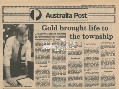
Newsclipping, Diamond Valley News, Gold brought life to the township, Diamond Valley News, 2 July 1985, p17, 2 Jul 1985
A history of Eltham Post Office. Australia Post: Gold brought life to the township - Diamond Valley News, Tuesday July 2, 1985, p17 On February 1, 1854, the first Eltham Post Office was established, commencing an association between the township and the Postmaster-General's Department that has continued for 131 years. At that time, the number of permanent residents would have been fairly small, probably less than 200. The discovery of gold in June 1851, at Anderson’s Creek, some five miles away, and later at Caledonia Diggings, Queenstown (now known as St Andrews), about 14 miles to the north-east, brought large numbers of prospectors passing through the township, hopefully culling the creeks and gullies for the precious metal. This additional "floating population" brought a greater demand for supplies and for communication with the outside world, and so it helped in the development of Eltham. Today, Eltham is a thriving township. It boasts an excellent shopping centre, municipal offices, court house. post office and many other amenities. Eltham continued to develop at a leisurely pace. During 1860, a total of just over 8000 postal articles were handled at the Eltham Post Office. By 1862, the mail route was "to and from Melbourne by way of Eltham and Kangaroo Ground, three times a week, by coach". There was also a branch mail that operated between Eltham and Greensborough, three times weekly. This was also conveyed by coach. Some time between 1864 and 1868 the management of the post office passed from Thomas Hunniford to his daughter, Miss Anne Hunniford, who managed the Eltham Post Office until her death in 1928. A big improvement in communication was provided for Eltham residents when a telegraph office was established at the post office in 1877. During 1923 a manual telephone exchange was provided at Eltham, the first two subscribers being J.J. O’Connor and Eltham Police Station. In 1949 the manual exchange was replaced by an automatic exchange and there were some 150 subscribers. Following the death of postmistress Miss Anne Hunniford in 1928, B.M. Burgoyne was placed temporarily in charge of the office. In 1929, J. N. Burgoyne was appointed postmaster, and he in turn was succeeded by H. C. Burgoyne in 1951. The post office was moved to a new site in 1954, but continued under the charge of Mr Burgoyne. In January 1958 there was a further change of site when the post office was raised to official status and transferred to new premises in Main Rd. William Donoghue was acting postmaster when the new office was opened. In March 1958 Mr W.E. Tovey was appointed postmaster, followed by Douglas McG. Gilmour in 1959. William Donoghue was fully appointed in 1966 and Barry Reichelt followed in 1973, prior to the present postmaster, Peter Jolly in November 1982. Peter is a young man with 18 years' experience. He commenced his training as a postal clerk at the training school in Melbourne in 1968 and was promoted to postal clerk at the Brunswick Post Office in 1969. He was finally transferred as postmaster to Fawkner Post Office in 1980. He has been at Eltham Post Office for the past 2½ years. He is married with one child and lives in Montmorency. The Eltham Post Office employs a staff of 21, of whom seven are indoor staff, 12 are postmen and two are drivers. The postmen in Eltham have an uphill battle delivering mail because of the hilly terrain. Nine of the postmen deliver mail on motorbikes, and the two delivery vans are both four wheel drives. Eltham Post Office services basically a residential area, with deliveries to 5600 homes. This is growing at the rate of 600 homes every 18 months, i.e. about 32 homes per month. At the present rate we will need a new postman every 18 months.Digital file only - Digitised by EDHS from a scrapbook on loan from Beryl Bradbury (nee Stokes), daughter of Frank Stokes.anderson's creek, anne hunniford, b.m. burgoyne, barry reichelt, beryl bradbury (nee stokes) collection, eltham police station, eltham post office, eltham post office history, gold, h.c. burgoyne, j.j. o'connor, j.n. burgoyne, peter jolly, postmaster, telephone exchange, thomas hunniford, w.e. tovey, william donoghue -
 Marysville & District Historical Society
Photograph (item) - Black and white photograph, Nicholas John Caire, 1878-1904
An early black and white photograph of a Cumberland Valley giant tree.An early black and white photograph of a Cumberland Valley giant tree. This photograph was taken by Nicholas John Caire between 1878 and 1904. Nicholas John Caire was born in 1837 in Guernsey. He arrived in Adelaide about 1860 along with his parents who encouraged his early interest in photography. He opened a studio in Adelaide in 1867 after traveling extensively throughout the Gippsland taking photographs. After marrying in 1870 he moved to Talbot in Victoria until 1876 when he opened a studio in the Royal Arcade in Melbourne. After 1885 Nicholas John Caire gave up his city work and made his home in South Yarra and devoted the rest of his life to outdoor photography, specializing in the bush, the gullies, and the mountains of south-eastern Victoria. big tree, mountain ash, cambarville, victoria, photograph, cumberland valley, nicholas john caire -
 Linton and District Historical Society Inc
Photograph, Mary Ellen Hart, sewing mistress Happy Valley school
Mary Ellen Hart, sewing mistress at Happy Valley State School, married William Charles McNamara in 1895.Sepia photograph of a fresh faced young woman with dark hair drawn back from face, wearing long sleeved gown with necklace, standing with hands resting on an article at waist height."Mary Ellen Hart, sewing mistress Happy Valley school Married William Charles McNamara 5.6.1895 Linton RC".mary ellen hart, mrs william charles mcnamara -
 Mt Dandenong & District Historical Society Inc.
Photograph, View Up Valley At Kalorama
John Lundy-Clarke grew up in the Kalorama/Mt Dandenong area and later in life (1972-74) began to write a comprehensive history of the area working from an original settlement map in an effort to cover all areas. The building in the centre of the photograph is 'Kia-Ora' guest house. Situated on Barber’s Road, ‘Kia-Ora’ was built in 1912 by George Barber. It was later leased by a Mrs Pemberthy. “Kia-Ora’ was one of four places connected when the telephone was brought into the district in 1912. The other places were ‘Mountjoy’, ‘Cherry Farm’ and ‘Callum House’. ‘Kia-Ora’ was burnt down in 1924. Black and White copy of section of a Rose Series postcard. Shows view up the valley at Kalorama with a decorative building centre middle of photograph. Handwritten description by John Lundy-Clarke on reverse.View up valley at Kalorama from near junction of Barbers and Doughty’s Rds. “Kia Ora” guest house in centre. Paynter’s “Iona” top left with “Kalorama” to its right. About 1912. Rose Series copied by JLC 1973.kalorama, kalorama valley, john lundy-clarke, barbers road, george barber, kia-ora, guest house, iona -
 Greensborough Historical Society
Article - Newspaper Clipping, Diamond Valley Leader, High honours for community work, 07/05/2003
Among the Diamond Valley residents awarded a Centenary of Federation Medal in 2001, were Cr. Colin Brooks and Rosie BrayNewspaper clipping, text, with photographs of several Diamond Valley residentsbrooks family, rosie bray, centenary of federation medal, colin brooks, community honours -
 Kiewa Valley Historical Society
Folder - Kiewa Methodist Church, 1917 to 1962
The copy of a letter written by Harry H. Simmonds of Huon notes that "the church existed in 1905. It was built by Hill and McCormack with timber donated by Mr Ned Dunstan on ground donated by Mr James Thomas probably in the late 1800s. It was possibly called a Methodist Church because the donor of the land was a Methodist. It was used by the three Protestant Groups and maintenance was paid for by an annual area collection.The house on the west side was a Presbyterian Manse for many years and the block of ground on the north side was known as the Manse paddock in which the minister grazed his cow and horse." In 1936 there was a fence between the Kiewa Methodist Church was the Presbyterian Church in Kiewa. Its Certificate of Title is Volume 5134 Folio 1026783 (Sept. 1942.) In 1952, the church was made of wood with an iron roof. In 1954. Request to Yackandandah Shire re a fence from Kiewa Consolidated School entrance to the unused hedge adjacent to the Church. In 1958 there was correspondence re 'the strip of land on each side of the Church.' Churches were an important part of life during the late 19th century and early to mid 20th century and were built in the centre of town as was this one. These papers give an understanding of the work involved in maintaining a church. The letters and 'book' give a lot of names of local families involved with the Methodist Church at Kiewa. Yellow plastic spiral folder with 18 pages enclosed in clear plastic sleeves.Papers enclosed include accounts, payments, tenders and other correspondence relating to the Methodist Church at Kiewa dating from 1932 to 1962. Of particular interest is a black cardboard cover book dated 1917 re collection of donations from listed people. The latest date in the book is 1942.Enclosed in first plastic sleeve is a letter from the donor, Kathie Vines dated 15th July 2013methodist church; kiewa; harry h. simmonds; yackandandah council; -
 Kiewa Valley Historical Society
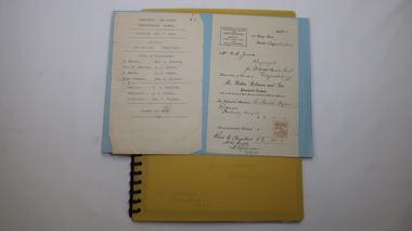
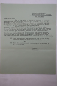
Letter - Medical Society - 9th July 1962
Ron White's Collection. The Kiewa Hydro Scheme included a Board of Management for the Kiewa Works Medical Society whose constitution required an amalgamation with a larger Society or be deregistered by the Commonwealth Health Department.Historically significant as the Kiewa Hydro Electric Scheme had been completed and Mt Beauty had been handed over to the Shire.Green A4 paper dated 2nd July 1962 re Kiewa Works Medical Society amalgamating with Latrobe Valley Health Service.ron white, kiewa works medical society -
 Kiewa Valley Historical Society
Map - Topographical, Ski Club of Victoria Bogong High Plains and Adjacent Peaks, Early 1930's
This map has been in the Ryder family for approx. 70 years. Probably used when bush walking and skiing in the early days on the Bogong High Plains. The Ryder family are farmers in the Kiewa Valley and were involved in taking their cattle up to the Bogong High Plains where they had a lease. The State Electricity Commission of Victoria constructed the Kiewa Hydro Electric Scheme opening up the area during the 1940's and 1950's. This type of map is an early one, used by people in the Kiewa Valley and possibly by surveyors prior to construction.The map is an early topographic map used by farmers living in the Kiewa Valley. It is historically significant as these people were involved in taking cattle up to the High Plains during summer and may have been used for bush walking and skiing.This is a sepia coloured paper map which was originally printed copyright registered. It was revised in 20/6.33/4.4.37/8.4.40/24.8.43/19/6/54. It shows roads / tracks / snow poles / snow pole numbers (27) / Snow pole spacing (3 chains. 66 yards) approximately 27 poles to the mile / height above sea level in feet - 5280. Water courses not definitely located etc.Rocky Valley Dam (Kiewa Hydro Electric Scheme) has been drawn on the map by hand with a biro. There is a wooden rod at the top of the map.topographic map; kiewa valley; ryder family; high plains of victoria -
 Greensborough Historical Society
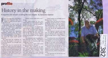
Newspaper clipping, Diamond Valley Leader, History In The Making, 2009_
Records the employment history of GHS President Noel Withers with the Shire of Diamond Valley.Highlights that residents' concerns from 40 years ago are similar to concerns in the current era.A Diamond Valley Leader article on the retirement of Noel Withers, written by Genevieve Gannon.Nilshire of diamond valley, noel withers, greensborough plaza, greensborough swimming pool