Showing 518 items
matching map of mine
-
 Bendigo Historical Society Inc.
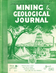
Book - MINING & GEOLOGICAL JOURNAL VOL.2, NO 4, 1941
... , articles on mines, photographs, illustrations, maps...GOLD MINES mining Mining - Mines - Mining Equipment Axedale ...Mining & Geological Journal, March 1941, Vol.2, No.4. Published by Department of Mines Victoria, 136 pages of Mine Reports, articles on mines, photographs, illustrations, maps & advertisements. Name on cover A.Richardson 29 Harrison St Bendigo.Dept of Mines Victoriagold mines, mining, mining - mines - mining equipment, axedale - fletchers mine. -
 Bendigo Historical Society Inc.
Booklet - Victoria Hill - A historical Background
BHS CollectionsSpiral bound booklet (24 pages) entitled 'Victoria Hill' a historical background of Victoria Hill and the surrounding area. Colour image of a poppet head on front cover. Illustrated with B&W and colour photos and a map. Revised and edited in 2012 by Philip Wilkin from an original article by Mr. Albert Richardson 'The Rich Victoria Hill and its historical associations.'Signed in ink 'Philip Wilkin 3rd May 2012' on page 3victoria hill, gold mines -
 Bendigo Historical Society Inc.
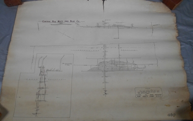
Administrative record - Central Red White and Blue Company Mine map
... Central Red White and Blue Company Mine map... Gold Mine Map Draftsman's drawing of Central Red, White ...Draftsman's drawing of Central Red, White and Blue Mine. Printed by Troedel & Cooper Pty Ltd, Surveyor Mr. H. Cumby, Bendigo April 1913 Forms part of the Margaret Roberts Collection of mining records.bendigo, margaret roberts, gold, central red white and blue gold mine, map -
 Bendigo Historical Society Inc.
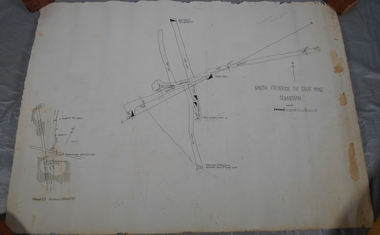
Administrative record - South Frederick The Great Mine, Sebastian, Mine map
... South Frederick The Great Mine, Sebastian, Mine map... Mine Pencil markings additions to map Draftsman's drawing ...Draftsman's drawing of South Frederick The Great Mine, Sebastian. Forms part of the Margaret Roberts Collection of mining records.Pencil markings additions to mapbendigo, margaret roberts, gold, map, south frederick the great mine -
 Bendigo Historical Society Inc.
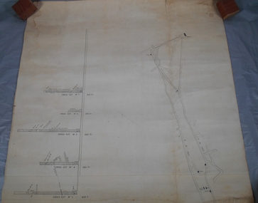
Administrative record - South Frederick The Great Mine, Sebastian, Mine map
... South Frederick The Great Mine, Sebastian, Mine map... record South Frederick The Great Mine, Sebastian, Mine map ...Draftsman's drawing of South Frederick The Great Mine, Sebastian. Transverse and longitudinal Plan Forms part of the Margaret Roberts Collection of mining records.bendigo, margaret roberts, gold, map, south frederick the great mine -
Lakes Entrance Historical Society
Book, Dyce, G.R, Combienbar The Valley of Contentment, 1982
An account of the early settlers of Combienbar, East Gippsland, Victoria - their struggles and achievements to 1945. Illustrated with photographs and includes map of the valley.settlers, agriculture, mines and mining -
Lakes Entrance Historical Society
Book, Drew G J, Discovering Historic Burra, 1998
A description of the historic copper mining area of Burra, South Australia with maps tourist trail photographs.historic sites, township, mines and mining -
Bendigo Historical Society Inc.
Map - SECTIONS ACROSS BENDIGO GOLDFIELD
Map in three sections showing sections across Bendigo Gold Field, showing anticlines, synclines, faults, stratigraphical zones and mines along the reef lines. Key shows rock types Castlemaine, Bendigo B1, B2, B3 and B4, and Lancefieldian. First part of map shows sections A-A, B-B and C-C. Reef lines drawn with mines listed: Fault line shown are the Carshalton, Stafford, New Chum, Virginia and Clarence. A datum line shows 600 ft above sea level. On bottom of plan: ' Prepared in the Geological Survey Office, Bendigo, under the direction of H. Herman, late Director of Geological Survey, from surveys by H.S. Whitelaw, Field Geologist, assisted by E.S. Usher, A.J.J. Moore and R.A. Keble.' Second section of map shows sections D-D, and E-E. Fault lines listed are the Tambour Major fault, Carshalton fault, Stafford fault, Nell Gwynne fault, New Chum fault, Deborah fault. Third section shows sections F-F and G-G. Fault lines listed are the Bird Reef fault, Kangaroo Gully fault, Langdon fault, Carshalton fault, Nell Gwynne fault, Spring Gully fault, Hustlers fault, Gravel Hill fault, Ordes fault, Thanet fault. This map forms part of the Geological Survey of Victoria, Structure of Bendigo Goldfield report, No. 47, 1923. H.Herman, late Director of Geological Survey.Geological Survey of Victoriabendigo, gold mining, reef line maps -
Bendigo Historical Society Inc.
Map - BENDIGO GOLDFIELD VERTICAL PROJECTIONS
Map of Bendigo Gold Field in two sections showing 'vertical projections along several anticlinal axial planes showing pitch, stratigraphical zones, faultlines, shafts and etc.'. Bulletin No 47 written top left hand side. Lines of reef described: Christmas line Lancashire line Nell Gwynne line New Chum line Hustlers line Garden Gully line Sheepshead line Mines along the reef lines are listed. This map forms part of the Geological Survey of Victoria, Structure of Bendigo Goldfield report, No. 47, 1923. H.Herman, late Director of Geological Survey. On bottom of second section : Prepared in the Geological Survey Office, Bendigo, under the direction of H. Herman, late Director of Geological Survey, from surveys by H.S. Whitelaw, Field Geologist, assisted by E.S. Usher, A.J.J. Moore and R.A. Keble.Geological Survey of Victoriabendigo, gold mining, reef lines -
 Federation University Historical Collection
Map, Ballaarat Gold Field, 1861, 1861
... map ballarat east lake wendouree survey mines robert davidson ...A party of surveyors camped by Yuille's Swamp (later Lake Wendouree) and surveyed the countryside for a map to be produced by the Geological Survey of Victoria. In November 2004 the Central Highlands Regional Library presented a special edition of 200 copies of the 1861 map reproduced from a copy in their collection. Original 1861 map of Ballarat showing streets and leads. Blue dots indicate gold leads, and red lines indicate auriferous quartz reef and outcrops of quartz veins."Compiled & Drawn from the Survey of Mining Surveyors Davidson, Fitzpatrick and Cowan & the Plans in the Surveyor General's Office by J. Brahe, 21st October 1861. R. Brough Smyth, Secretary for Mines. The Honourable J.B. Humffray, M.L.A. Commr of Mines.”ballarat, map, ballarat east, lake wendouree, survey, mines, robert davidson, ballarat gold field 1861, yuille's swamp, wendouree swamp, little bendigo diggings, gold leads, old post office hill, specimen hill, bakery hill, black hill, dead horse creek, brown hill, pennyweight hill, clayton hill, soldiers hill, golden point, gum tree flat, white flat, poverty hill, chinese village, robert brough smyth, ballarat map 1861, ballaarat vineyard, dead horse gully, deadhorse creek, invermay, black hill flat, gaelic church, police reserve, magpie range, dalton's flat, caadian lead, rifle butts, powder magazine, bathing house, government camp, gold office, chinese, llanberrris, victoria theatre, charlie napier hotel, united states hotel, grape's hoel, clayton's hill, cattleyard hill, free trade hotel, esmond lead, bakery hill, black hill lead, juvenile reformatory, ballarat orphanage, lady barkly lead, triffet's slaughter yard, little bendigo, melbourne road, t. cowan, thomas cowan -
 Bendigo Historical Society Inc.
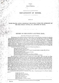
Document - STRAUCH COLLECTION: DEPT OF MINES,REPORT ON HUNTLY ALLUVIAL LEAD
BHS Collection1898 Victoria Department of Mines report on the Huntly Alluvial Lead with assorted maps.mining, extraction, alluvial -
 Bendigo Historical Society Inc.
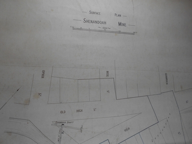
Administrative record - Shenandoah Mine Surface plan
... Draftsman's drawing Shenandoah Mine Surface Plan Map...Bendigo Margaret Roberts gold Map Mine Shendandoah Mine ...Draftsman's drawing Shenandoah Mine Surface Plan Map. Forms part of the Margaret Roberts Collection of mining records.bendigo, margaret roberts, gold, map, mine, shendandoah mine -
 Bendigo Historical Society Inc.
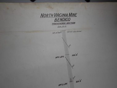
Administrative record - North Virginia Mine Bendigo Transverse Section
... Draftsman's drawing North Virginia Mine Transverse Section...Bendigo Margaret Roberts gold Map Mine North Virginia Mine ...Draftsman's drawing North Virginia Mine Transverse Section Map. Forms part of the Margaret Roberts Collection of mining records.bendigo, margaret roberts, gold, map, mine, north virginia mine bendigo -
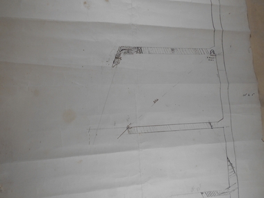
 Bendigo Historical Society Inc.
Administrative record - Lightning Hill Coy
... Bendigo Margaret Roberts gold Map Mine Lightning Hill Coy ...Draftsman's drawing Lightning Hill Coy Map. Forms part of the Margaret Roberts Collection of mining records.bendigo, margaret roberts, gold, map, mine, lightning hill coy -
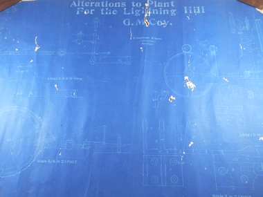 Bendigo Historical Society Inc.
Administrative record - Lightning Hill Coy
... Bendigo Margaret Roberts gold Map Mine Lightning Hill Coy ...Draftsman's drawing Alterations to Lightning Hill Coy plan Map. Forms part of the Margaret Roberts Collection of mining records.bendigo, margaret roberts, gold, map, mine, lightning hill coy -
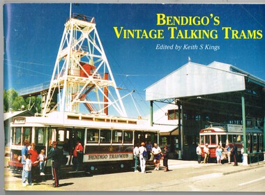 Melbourne Tram Museum
Book, Keith Kings, "Bendigo's Vintage Talking Trams", 1999
Book - 100 pages, plus printed colour covers on gloss paper, centre stapled, titled "Bendigo's Vintage Talking Trams", authored by Keith Kings1996, published by the Bendigo Trust December 1981. Has many historic photos of Bendigo, trams in the streets of Bendigo and its then fleet of trams. Gives a history of the trams in Bendigo, including battery tram, steam, ESCo, SEC, the Trust, Central Deborah Gold Mine and its trammies. Pages 49 to 52 - colour pages including a map of the route and staff and volunteers 30/10/1996.Page 1 note in ink "To Charles 20/2/97 Keith Kings"trams, tramways, bendigo, battery trams, bendigo trust -
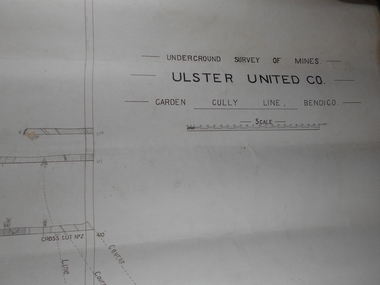 Bendigo Historical Society Inc.
Administrative record - Ulster United Co
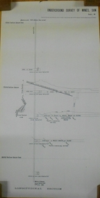
... Bendigo Margaret Roberts gold Map Mine Ulster United Co ...Draftsman's drawing Underground Survey of Mines Ulster United Co. Garden Gully Line Bendigo Map. Forms part of the Margaret Roberts Collection of mining records.bendigo, margaret roberts, gold, map, mine, ulster united co -
 Bendigo Historical Society Inc.
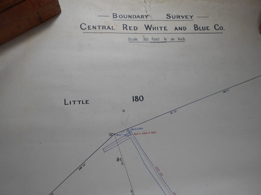
Administrative record - Central Red White and Blue Mine Map
... Central Red White and Blue Mine Map...Bendigo Margaret Roberts gold Map Mine Central Red White ...Draftsman's drawing Boundary Survey of Central Red White and Blue Co Map. Handwritten signature of Garnet G Buich, Licensed Mining Surveyor Forms part of the Margaret Roberts Collection of mining records.bendigo, margaret roberts, gold, map, mine, central red white and blue -
 Bendigo Historical Society Inc.
Administrative record - Confidence Cornish Kocks & Windmill Hill
... Bendigo Margaret Roberts gold Map Mine Confidence Cornish ...Draftsman's drawing Confidence Cornish Kocks & Windmill Hill Long and Transverse Sections Forms part of the Margaret Roberts Collection of mining records.bendigo, margaret roberts, gold, map, mine, confidence cornish kocks & windmill hill -
 Bendigo Military Museum
Manual - MOTOR REGIMENT PRECIS, Aust Army - A.F.V. School, Motor Regiment Wing, August 1942
Items in the collection re Lt. Col. Swatton, refer Cat No 6719.2P for his service details.This is a handmade folder holding foolscap sheets. The sheets are printed on both sides. Some of the sheets have drawings of patrol formations, maps and how to make booby traps. It has several pages of Japanese Battle procedures. The book is bound with 2 metal clips. It has R.T. Procedures, Land Mines and barbed wire entanglements.Written on front is "MAJ. Priddle". Inside front cover, on a sticky label is "On loan from the estate of Colonel J. W. Swatton Ref No. JWS M36". passchendaele barracks trust, battle procedures -
 Bendigo Historical Society Inc.
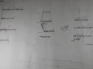
Document - MARKS COLLECTION: NEW CHUM LINE OF REEF MAP
Plan (copy) of New Chum Line of Reef. Plan has been copied in two sections. On top of plan 'Underground survey of mines Sandhurst, New Chum Line of Reef', plan shows longitudinal and cross section views of the workings on the reef. Shaft No. 76 marked. Datum line on top indicates 750' above sea level, on bottom of plan, bottom of shaft 2022.24 below sill. Drawn by Arthur Everett, Mining Department, Melbourne, 1884.bendigo, mining, new chum line of reef -
 Bendigo Historical Society Inc.
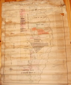
Map - MARKS COLLECTION: MAP MINES BALLARAT AREA 1887
... Large buff coloured map, wooden strip on bottom, top hanger... map, wooden strip on bottom, top hanger missing, showing mine ...Large buff coloured map, wooden strip on bottom, top hanger missing, showing mine boundaries in Ballarat mining area. Mines include from top of map Bonshaw No. 1; Band and Albion Consolidated Company; Central Bonshaw; North Bonshaw; Star of the East block Claim; Star of the East; South Star; Owen's Freehold; Central Plateau; Sebastopol Plateau Company; Sebastopol Star; Sebastopol Plateau No. 1; South Plateau; Prince of Wales; Bonshaw United company; Gay's Freehold. Map prepared by Robert Alan, under the direction C.W. Langtree, Secretary for Mines, and Chief Mining Surveyor.map, ballarat, ballarat, mining, goldmining -
 Bendigo Historical Society Inc.
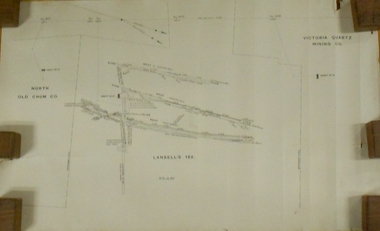
Plan - MARKS COLLECTION: LANSELL'S 180 PLAN, LEVELS 18, 19 AND 20
Plan of underground section of Lansell's 180 mine, levels 18, 19 and 20. On RH side of map Victoria Quartz Mining company claim marked, on LH side North Old Chum Co. 'West or hanging wall' marked above each level.bendigo, mining, lansell's little 180 mine -
 Bendigo Historical Society Inc.
Document - NEW CHUM SYNCLINE MINE - NOTES ON THE NEW CHUM SYNCLINE MINE
Typed copy of notes on the New Chum Syncline Mine on the Nell Gwynne Line of Reef. Notes include depth of shaft, years of working, size of lease, locality, plant, best gold and total gold yield. Small locality map attached to front. Albert Richardson Collection.document, gold, new chum syncline mine, new chum syncline mine, notes on the new chum syncline mine, walker & coy bundaberg, cameron & sutherland, little 180, central deborah, mines department booklet 'bendigo goldfield' 1936, mines dept annual and quarterly reports, a richardson -
 Bendigo Historical Society Inc.
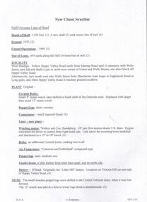
Document - NEW MOON MINE - NOTES ON THE NEW MOON MINE
Four typed copies of notes on the New Moon Mine on the Garden Gully Line of Reef. Notes include locality, depth of shaft, last year of production, size of lease, plant, Telephone and electric signalling, early history, gold obtained, prominence, gold production and dividends. Hand drawn locality map included. Albert Richardson Collection.cottage, miners, new moon mine, notes on the new moon mine, h harkness & coy, thompson & co, telephone & electric signalling, 'robin hood' ground, bendigo amalgamated goldfields co, special edition australian mining standard 1/6/1899, mines dept booklet 'bendigo goldfields' 1936, mines dept annual and quarterly reports, annals of bendigo mining section 1907 = 1931, a richardson, souvenir 'declaration of 200th dividend' issued by directors of new moon co 1/12/1906, mines dept bulletin 47 'structure of bendigo goldfields' h herman 1923 -
 Bendigo Historical Society Inc.
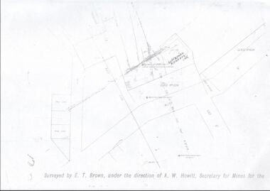
Map - LANSELL'S BIG 180 MINE - LOCALITY OF LANSELL'S NO 180 SHAFT
... MAP Bendigo mining plan Lansell's Big 180 Mine Locality ...Buff coloured photocopy of the location of Lansell's No 180 Shaft and showing the positions of Underground Workings near the intersection of Lily St and Alley St. Also mentioned are the North Old Chum Shaft and the New Chum and Victoria Co Shaft. Luffman Brothers has been written in in pen and initialled A R. Printed at the bottom is: Surveyed by E. T. Brown, under the direction of A. W. Howitt, Secretary for Mines for the - (the rest is cut off).map, bendigo, mining plan, lansell's big 180 mine, locality of lansell's no 180 shaft, north old chum co shaft, new chum and victoria co shaft, luffman brothers, e t brown, a w howitt -
 Bendigo Historical Society Inc.
Document - MARKS COLLECTION: MAP OF VICTORIA REEF MINING CLAIMS
Copy of map. On bottom LH side: Plan of the Victoria Reef Sandhurst January 1867, Compiled by G.W. Hart, Mining Surveyor. Published by John N. Macartney, Argus Agent, Sandhurst. Price 4/- each. On bottom Rh side J.W. Pearson & Co. Lith. Melbourne Plan shows mining claims and names of holders, scale (4 chains to one inch) Loddon Road, Mount Korong Road, Ironbark Gully, township of Long Gully, Quartz Miners' Arms and Gold Mines Hotel on Loddon Road.bendigo, mining, victoria reef plan -
Clunes Museum
Pamphlet
A4 SHEET FOLDER IN THREE, COLOUR PRINTED. CRESWICK CEMETARY EST. 1858. AUSTRALASIAN NO. 2 MINE DISASTER AND NOTABLE CITIZENS WALKING TOUR. INCLUDES MAP OF CEMETARY.creswick cemetary, walking tour, australasian no. 2 mine disaster -
 Bendigo Historical Society Inc.
Map - NEW CHUM LINE, 1875
... MAP new chum line Gold mines New Chum line of Reef Plan ...Plan: Longtitudinal Section of the Northern Section of the New Chum Line of Reef. Compilation consisting of smaller sections stapled togethermap, new chum line, gold mines, new chum line of reef