Showing 413 items matching "mount pleasant road"
-
 Whitehorse Historical Society Inc.
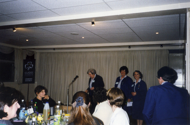
Photograph, Vermont Girl Guides 70th Anniversary in 1999
Coloured photograph of the celebrations at the 70th anniversary of the Vermont Girl Guides in June 1999. Venue is St John's church hall in Mitcham. At the microphone is Mrs Elaine Wallbridge who was the Nunawading/Mount Pleasant Division Commissioner 1981 - 1986.vermont girl guides, wallbridge, elaine, st john's catholic church hall, mitcham -
 Whitehorse Historical Society Inc.
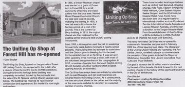
Article, Forest Hill Uniting Op Shop, April 2022
The Forest Hill Uniting Op Shop has been renovated and re-opened following closure during Covid restrictionsnon-fictionThe Forest Hill Uniting Op Shop has been renovated and re-opened following closure during Covid restrictionsmount pleasant methodist church, st. ninians uniting church blackburn south, wesleyan chapel, opportunity shops -
 Ballarat Tramway Museum
Slide - 35mm slide/s, Dave Simpson, late 1960's early 1970's
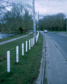
Yields information about Main Road, just before the intersection with Barkly St.One 35mm slide Anscochrome white plastic mounts of No. 13 with the destination of Mt Pleasant in Main Road, just before the intersection with Barkly St. with "Fish and Chips" shop in the background. Has a Tarax advert on the shop. (This shop was subsequently rebuilt with a car park next door, but is (27-8-16) now closed. In the foreground is a painted tram stop on a pole with a direction sign for the Ballarat East Baby Health Centre.tramways, trams, main road, mt pleasant, tram 13 -
 Ballarat Tramway Museum
Slide - 27 mm sq slide/s - set of 9 - tram tracks - Gardens to the City, Lilian Butler, Aug. 1971
Yields information about the streetscapes of Ballarat on the Gardens to Victoria St route and in particular buildings and people that crewed the trams.Set of nine Colour 27 x 27 mm slide in a Kodachrome cardboard mount of a series of photographs taken from Wendouree Parade in the Gardens to the City tramway - taken from the front or rear window of the tram. .1 - Carlton St loop looking north .2 - Wendouree Parade, north of the Windmill Drive north intersection - has a tram stop pole. .3 - Sturt St - in bound just past Pleasant St - has passengers waiting at the tram stop. .4 - at Ascot St. .5 - at Drummond St with Shell garage in the view and a track worker. .6 - at Talbot St? with track workers repairing the road surface. .7 - at Dawson St showing the tram stop and End of Section signs. .8 - nearing the intersection with Armstrong St. .9 - nearing Lydiard St. Slide mount date cannot be read - possibly August 1971. Photo from the collection of Lilian Butler.ballarat, tramways, trams, wendouree parade, sturt st, drummond st, trackwork, tram stops, carlton st loop -
 Ballarat Tramway Museum
Slide - 27 mm sq slide/s - set of 11, Lilian Butler, Wendouree Parade and Sturt St West, Sep. 1971
Yields information about the streetscapes of Ballarat depot to Pleasant St route and in particular buildings and people that crewed the trams.Set of eleven Colour 27 x 27 mm slide in a Kodachrome cardboard mount. .1 - Wendouree Parade looking west towards St Aidans Drive - the gate pillars can be seen. .2 - ditto looking west - Fairyland .3 - ditto looking towards Gardens Loop .4 - No. 41 at Gardens Loop, with destination of Gardens via Drummond North .5 - ditto showing Mt Pleasant .6 - ditto, just past the now BTM Depot Junction. .7 - Carlton St - showing the gates .8 - Looking towards Hamilton Ave from within Carlton St loop with the signal showing red. .9 - Turning from Hamilton Ave into Sturt St West. .10 - Sturt St west looking east with the Loreto convent walls on the left hand side. .11 - Sturt St - Pleasant St intersection - showing road surface, a tram coming towards the intersection and buildings on either side. Slide mount date September 1971. Photo from the collection of Lilian Butler.ballarat, tramways, trams, wendouree parade, st aidans drive, gardens loop, depot junction, carlton st, carlton st loop, signals, sturt st west, pleasant st, tram 41 -
 Ballarat Tramway Museum
Slide - 27 mm sq slide/s - set of 7, Lilian Butler, Mt Pleasant line, Sep. 1971
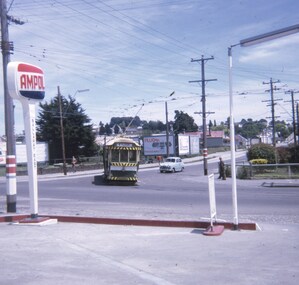
Yields information about the streetscapes of Stones Corner to Mt Pleasant route and in particular buildings and people that crewed the trams.Set of seven Colour 27 x 27 mm slide in a Kodachrome cardboard mount. .1 - Tram turning onto the Mt Pleasant line at Stones Corner - Bridge St, Main Road .2 - Main Road looking south with Inland Body Works building on the left and Ampol Service Station .3 - Mt Pleasant terminus with the butcher shop on the left and the diary on the right - shows the terminating tram track .4 - Conductor changing pole. .5 - Putting pole on the overhead .6 - Conductor (D O'Leary - No. 38) standing in front of tram and Motorman or driver (N. Hall - No. 43) .7 - ditto with number visible. See Reg item 3425 for crew lists. Slide mount date September 1971. Photo from the collection of Lilian Butler.ballarat, tramways, trams, stones corner, main road, mt pleasant, crews, drivers, conductors, trolley poles, tram 41 -
 Ballarat Tramway Museum
Slide - 27 mm sq slide/s - set of 5, Lilian Butler, Sturt St West, 1971
Yields information about Sturt St West track.Set of 5 AGFA slides - blue and white plastic mounts: .1 - Sturt St West curve into Hamilton Ave, looking west, shows road signs and the state of the road. .2 - Parker St, showing the west end of the loop and a Warning Oncoming Trams signs. .3 - West of Parker St, looking west. .4 - Curve at Pleasant St from Sturt St to Sturt St West. .5 - Curve into Hamilton Ave from Sturt St West. Photo from the collection of Lilian Butler. ballarat, tramways, trams, sturt st west, parker st loop, signs, pleasant st, hamilton ave -
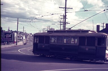
 Ballarat Tramway Museum
Slide - 35mm slide/s, David Verrier, 6/10/1964 12:00:00 AM
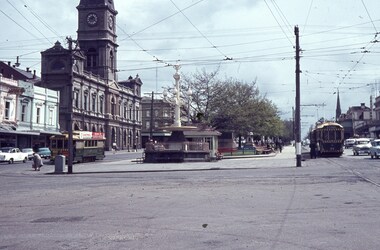
Yields information about the appearance of the City Centre tramway area, and the tram services that ran from there.Agfa colour slide, white blue plastic mount. Photograph by David Verrier of looking west at the intersection of Sturt and Lydiard St with trams 28 (south side)( Gardens), and on the north side tram 34 (Mt Pleasant) and behind it No. 40 (Lydiard St North). Has the Town Hall, tram stop shelter and the fountain in the view. Note the traction power electrical box on the corner with an elderly lady about to cross the road. Photo taken 6/10/1964.On back of slide in pencil "Tues 6/10/64 Ballarat, Sturt and Lydiard St, RT 34 Mt Pleasant, 40 Lydiard Nth LT 28 Gardens"tramways, trams, sturt st, tramway centre, lydiard st, town hall, tram 34, tram 40, tram 28 -
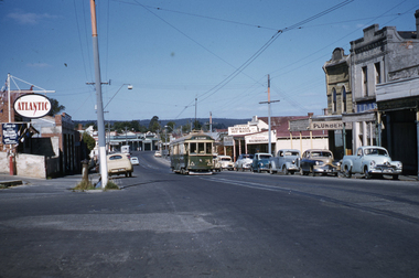 Ballarat Tramway Museum
Slide - 35mm slide/s, Ben Parle, 8/04/1958 12:00:00 AM
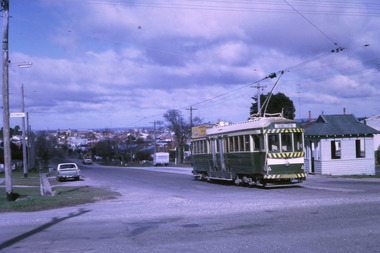
Kodachrome Transparency - 35mm slide - cardboard mount, with one side with red border and words "Kodachrome Transparency / Processed by Kodak" top and bottom. Photo taken by Ben Parle 8/4/1958, date stamped onto slide. Has slide No. "10" stamped in red in top corner. Photo of Ballarat 38, outbound in Main Road Ballarat near corner of Humffray St. Tram has the destination of Mt. Pleasant. Companies and shops in the image are: Atlantic Petrol, R.J. Henderson Hairdresser, W. N Symons Plumber. For high resolution scan see btm2882.tif See also Reg Item 7599 for an earlier photo of this area, gives the name of the plumbing shop as W. N. Symons."Mt. Pleasant line" / "8-4-58"tramways, trams, main st, main road, atlantic, tram 38 -
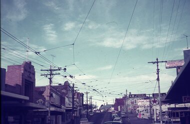
 Ballarat Tramway Museum
Slide - 35mm slide/s, Graham Evans, Sept. 1971
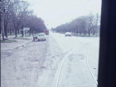
White cardboard mount, 35mm slide, from the Association of Railway Enthusiast's film strip titled "Provincial Tramway Film Strip" of No. 39 inbound along Sturt St. West. with many cars on the road. Bus stop on a pole on the other side of the road. The film strip notes (Reg. Item 2560), provided the following caption details: "Even more dangerous that the lakeside track, for motorists, was the Sturt St West (Western Highway) section of roadside trackage. Car No. 39 faces oncoming traffic on the regular through works to "Mt PLEASANT". - Sept. '71 (Graham Evans)" See image btm2573p.tif for high level scan of image. Stamped on base of slide "11783" and written in ink on top edge "No. 39 Sturt St West Ballarat"tramways, trams, are, film strip, sturt st west, western highway, tram 39 -
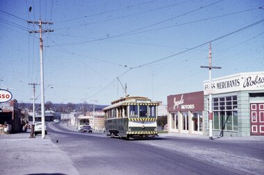 Ballarat Tramway Museum
Slide - 35mm slide/s, Campbell Duncan, 5/09/1971 12:00:00 AM
Yields information about the operations of the Ballarat Tramway system prior to closure and some of the tours that were operated. Kodak - Kodachrome slide - cardboard mounts Tram 26, with destination of City, inbound in Main Road, with Impala Motors and Robson Glass merchants in the background - 5/9/1971 - last day of Mt Pleasant line. See notesIn ink on slide: "Sunday 5 Sept. 1971, Approaching Bridge St from Mt. Pleasant, last day of Mt Pl. operation. This car provided, with preceding car No. 27, supplementary service to cater for Vintage train passengers who went to Sovereign Hill. They left City c1250, returned c1.05pm before first usual car. They ran as service cars b/c no specials allowed on last day."tramways, trams, main road, mt pleasant, sovereign hill, tram 26 -
 Ballarat Tramway Museum
Slide - 35mm slide/s - set of 4, Dave Simpson, late 1960's early 1970's
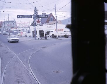
Yields information about Stones Corner and the traffic situation in Bridge St.Set of four 35mm slides - Anscochrome white plastic mounts of Stones Corner, corner of Bridge St, Victoria St and Main Road. .1 - shows the overhead arrangements, with a tram about to enter Bridge St from Main Road. Has the Caltex service station in the background, also advert or roof signs for Viscount Ambassador Caravans, K&O (Digger) Schonell Sports Cycles and Electrical store. .2 - No. 26 inbound with many passengers - showing Mt Pleasant - could be running a Special. .3 - ditto with many cars in the photograph. .4 - tram 39 about to enter Bridge St from Main Road - has a red letter box on corner.tramways, trams, main road, bridge st, victoria st, stones corner, tram 26, tram 39 -
 Ballarat Tramway Museum
Slide - 35mm slide/s - set of 2, Dave Simpson, late 1960's early 1970's
Yields information about the intersection of Main Road and Barkly St Mt PleasantSet of two 35mm slides - Anscochrome white plastic mounts of No. 13 turning from Main Road into Barkly St with the destination of Mt Pleasant. .2 - the tram has a Twin Lakes on the rear of the tram with a Morris motor car at the rear of the tram. In the background are roadside advertisements for HBA and Taubman's paints.tramways, trams, barkly st, main road, mt pleasant, tram 13 -
 Ballarat Tramway Museum
Photograph - Digital image Set of 10, Tony Smith, 1971
Yields information about Ballarat Tramways and trams prior to the closure of the tramway system.Set of 10 digital images of Ballarat trams prior to closure, scanned from original slides by Tony Smith, 1971 prior to closure of the system. .1 - 37 at the Lydiard St North terminus, with the shelter in the background. .2 - 33 at the Mount Pleasant terminus, has the corner store with a "The Sun" advertisement and the general store on the right side of the road in the background. Has signs for Streets Ice Cream and Coca Cola. Also has the tram stop signs - painted pole and enamel sign. .3 -33 arriving at the Mt Pleasant terminus with the conductor stepping off the back step, a lady walking across to the tram. Tram has a Twin Lakes sign. .4 - 11 at Victoria St terminus, with conductor turning the pole. Tram has a Twin Lakes sign. IN the background is the rail bridge over the Eureka line and a shelter. .5 - 11 in bound from Victoria St, shows the bleakness of the street at the time. Tram has Twin Lakes and a SEC Briquettes signs. .6 - 12 outbound to Mt Pleasant in Main St and the corner with Humffray St. Tram has a Twin Lakes sign. .7 - 11 in bound from Victoria St, in Bridge St, with junction in background. Tram has Twin Lakes and a SEC Briquettes signs. In the background are Rodda's, C.W. Pennant wall papers and Gill and O'Keffe footwear stores. .8 - 21 in Wendouree Parade, in bound to Victoria St, with the Lake in the background, near Macarthur St. .9 - 21 ditto, nearing the Macarthur St junction. Has the shelter and tram stop signage for View Point in the background. .10 - 34 sitting on the depot fan, 2 road, ready to run out. Has Mt Pleasant as the destination.trams, tramways, lydiard st north, mount pleasant terminus, victoria st, main st, bridge st, wendouree parade, macarthur st, view point, depot, tram 37, tram 33, tram 11, tram 12, tram 21, tram 34 -
 Ballarat Tramway Museum
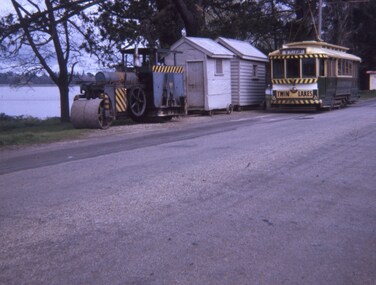
Slide - 27 mm sq slide/s, Andrew Howlett, Jelbart road roller and the two SEC worksheds, with No. 11 passing, Sept. 1968
Yields information about tram 11, the Jelbart roller and the two work sheds in Wendouree Parade. The work sheds were seldom photographed.Colour slides, Kodak white cardboard mount, developed Sept 1968 of No. 11, passing the Jelbart road roller and the two SEC worksheds in Wendouree Parade. No. 11 has the destination of Mt Pleasant and a Twin Lakes sign. ballarat, tramways, trams, wendouree parade, jelbart, trackwork, tram 11 -
 Ballarat Tramway Museum
Slide - 27 mm sq slide/s - set of 2, Andrew Howlett, Bogie tram turning from Main St into Barkly St, Dec. 1968
Yields information about the services in Barkly St East Ballarat.Set of two Colour slides, Kodak white cardboard mount, developed Dec. 1968 of: .1 - Bogie tram turning from Main St into Barkly St, on its way to Mt Pleasant. Shows the tram stops at this location and an Ampol Service station sign. .2 - possibly the same tram, in Barkly St.ballarat, tramways, trams, main road, barkly st, mt pleasant, tram 35, ampol, main st -
 Kew Historical Society Inc
Photograph - High Street looking north to Burke Road, 1907-08
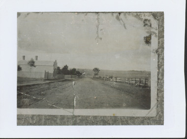
While a number of subdivisions of what was to become Kew East occurred in the 1880s, such as the 'Mount Pleasant Estate' (1888) and 'Monterey Estate' (1888), Glynn's Lot 91 remained open farmland until the Harp Estate (1912) was sold, hence the undeveloped nature of the view in 1907-8.A rare image of the open farmland in the eastern part of Kew looking towards Burke Road in 1907-8.Damaged, and very rare, black & white photograph of what was to become the suburb of East Kew, taken by a member of the Bennett family in 1907-8. The photograph is taken from the Harp of Erin Hotel showing, apart from a building on the left (no longer extant), fenced open farmland stretching into the far distance.HIGH ST LOOKING NOTRTH TO BURKE RD FROM HARP / EDWD GLYNN'S LOT 91 FROM 1851 / GIFT FROM BENNETT FAMILY 22 HARP RD EAST KEW 1980 / 1907-8harp of erin, high street -- east kew (vic), harp estate -
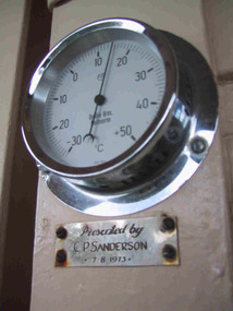 Parks Victoria - Mount Buffalo Chalet
Gauge, temperature
Appears to be original to Mt Buffalo Chalet. "A number of specific items, which have been useful in the day to day operations of the Chalet, remain in the building with each complementing the other to provide context, meaning and character to their setting. Items such as the hall porter bell, the many signs providing information to the guests, the wall clock, barometer and dinner bell point to the Chalet being a well-run social institution with a pleasant environment for rest, recreation and congenial company." (Pg 81 Historica, MBCC) This temperature gauge has a plaques inscribed "Presented by C.P Sanderson 7/08/1973. It is not known who this person was. Listed in Draft Inventory of significant Collection items. A.3 Fixtures and fittings. (Pg165 Historica Cultural Heritage Projects. Mount Buffalo Chalet collection. Prepared for Parks Victoria, 2011)Listed in Draft Inventory of Significant Collection ItemsSmall circular silver coloured temperature gauge mounted to wall. Plaque attached below temperature gauge. Face is white and has a glass cover.Plaque below barometer: "Presented by C P Sanderson / 7 - 8- 1973" -
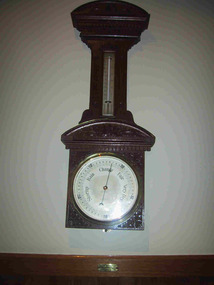 Parks Victoria - Mount Buffalo Chalet
Barometer
"A number of specific items, which have been useful in the day to day operations of the Chalet, remain in the building with each complementing the other to provide context, meaning and character to their setting. Items such as the hall porter bell, the many signs providing information to the guests, the wall clock, barometer and dinner bell point to the Chalet being a well-run social institution with a pleasant environment for rest, recreation and congenial company." (Pg 81 Historica, MBCC) "The barometer mounted on an ornately carved backing was presented by flour miller John Spencer Brunton (1861-1937), son of Thomas Brunton who founded the Brunton & Co. flourmills. John had responsibility for the New South Wales arm of the company and lived in Sydney.' (Pg 82 Historica MBCC) " Fig 80. It was presented by John Spencer Brunton on 9 December 1930."(Pg83, Historica. MBCC) Listed in Draft Inventory of Significant Collection items A.3.. Fixtures and Fittings (Pg 165.Historica, MBCC)Barometer and thermometer with carved decorative leaf pattern wooden surround.On plaque below barometer:"PRESENTED BY / JOHN SPENCER BRUNTON / 9.12.30" (further inscriptions on face) -
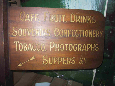 Parks Victoria - Mount Buffalo Chalet
Signs
Original directional signs from Chalet interior. Dated to pre 1960's. "A number of specific items, which have been useful in the day to day operations of the Chalet, remain in the building with each complementing the other to provide context, meaning and character to their setting. Items such as the hall porter bell, the many signs providing information to the guests, the wall clock, barometer and dinner bell point to the Chalet being a well-run social institution with a pleasant environment for rest, recreation and congenial company." (Pg 81 Historica, MBCC) Listed in Draft Inventory of Significant Collection Items. Appendix A.3 Fixtures and Fittings. (Pg 165 Historica MBCC) Varnished wooden directional signs with painted gold lettering to direct guests through the chalet to the cafe and the guests drying room. Signs have rounded edges and are attached to a vertical post.1. "Cafe, fruit, drinks, souvenirs, confectionary, tabacco, photographs, suppers etc." 2. "GUESTS DRYING ROOM" -
 Whitehorse Historical Society Inc.
Document - Real estate notes, maps, flyers, Trove Park Estate, 1969, 2022
A history of the Trove Park Estate, Vermont from 1880's to 2022 is provided by notes, maps, pictures and auction flyers. The Estate was originally part of the Uplands Estate of 34 acres in the Mount Pleasant district.A history of the Trove Park Estate, Vermont from 1880's to 2022 is provided by notes, maps, pictures and auction flyers. The Estate was originally part of the Uplands Estate of 34 acres in the Mount Pleasant district.A history of the Trove Park Estate, Vermont from 1880's to 2022 is provided by notes, maps, pictures and auction flyers. The Estate was originally part of the Uplands Estate of 34 acres in the Mount Pleasant district.trove park drive estate vermont, mt pleasant, trove park, uplands vermont, bishop edward, round chris & murray, mulcahy mendelson & round, trove park drive vermont no 7 -
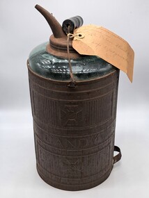 Glenelg Shire Council Cultural Collection
Functional object - Kerosene Container, Dandy, 1900s
This glass kerosene lamp was used at St Peter's Church of England at Cape Bridgewater. From Victorian Heritage Database - St. Peter's Anglican Church (former) is a small sandstone church, located at the end of Bridgewater Fire Station Road. The church was constructed between 1883-1884, as a result of lobbying by the congregation and the Reverend Allnutt to establish an Anglican Church in the area. The area was predominately Presbyterian and Methodist, so such a fine church was somewhat unusual. There was obviously much community support for the establishment of the church; the land was donated by Kennedy, a nearby landholder, and the stone was quarried for free at Mount Pleasant, owned by the Kittson family. The church was designed gratis by the ecclesiastical architect, Mr. Casselli of Ballarat, who designed many significant buildings throughout Victoria in the nineteenth century. The building contractors were a local firm, Messrs. Benson and Hardie. The church retains a high degree of integrity externally, and is in good condition. This item is significant because it demonstrates early methods of storing fuel. It is also connected to St Peter's Anglican Church in cape Bridgewater which is now a visitor accommodationA glass container with a metal sleeve. The top of the glass container has a metal opening and screw top as well as a spout for pouring. There is a metal carry handle with a wooden cylinder in the middle for carrying. This is only fixed to the container on one side as the metal eyelet on one side has broken off. The metal sleeve on the glass container has embossed pattering above and below the word - Dandy. There is an old carboard label attached to the top with string.Metal sleeve - DANDY Label -This kerosene container was used in / St Peter's Church of E / Cape Bridgewaterreligion, church, place of worship, cape bridgewater, st peters church, anglican, glenelg shire, glenelg, portland, fuel, kero, kerosene, light -
 Ringwood and District Historical Society
Document - Research Notes, Richard Carter, Land Subdivisions in Ringwood 1890-1950
... ?) (1920) Eastfield Road, Longview Road, Pleasant Rise, The Mount...?) (1920) Eastfield Road, Longview Road, Pleasant Rise, The Mount ...Handwritten table listing main local pre-1950s subdivisions in the Ringwood area, with estate names, streets, number of allotments for sale, and where known, vendor agent, LP (Lodged Plan) title registration number, and auction/sale date, some with sale price.Pg1 RINGWOOD STATION ESTATE LP3070 (Year?) Station Street, William Street (now Kendall Street), Wantirna Road, Station Street Pg1 RINGWOOD TOWNSHIP ESTATE LP5577 (1913) Station Road (now Warrandyte Road), Pratt Street (part now Aird Street), Whitehorse Road Pg2 RINGWOOD ORCHARD ESTATE LP4315 (1914) Brysons Road, Hillcrest Road, Anzac Avenue, Sulva Road Pg3 RINGWOOD RAILWAY ESTATE LP7522 (1918) Whitehorse Road (now Mount Dandenong Road), Dublin Road, Freeman Street, Patterson Street, Bona Street Pg4 THE RINGWOOD ESTATE LP7578 (1919) Warrandyte Road, Hobart Street, Paxton Street, Arnold Street Pg5 GARDEN FARMS ESTATE (LP?) (1919) Canterbury Road, Armstrong Road, Bungalook Road, Orchard Road, Bayswater Road (now Mountain Highway) Pg6 THE RINGWOOD ESTATE (SECOND SUB-DIVISION) LP7604 (1919) Warrandyte Road, Tamar Street, Derwent Street, Mersey Street Pg7 RINGWOOD STATION ESTATE LP7703 (1919) Bedford Road, Williams Grove (now Lena Grove) Pg8 RINGWOOD TOWNSHIP ESTATE LP8198 (1919) Wantirna Road, Ellison Street, Haig Street, Greenwood Avenue Pg9 EASTFIELD ESTATE (LP?) (1920) Eastfield Road, Longview Road, Pleasant Rise, The Mount Pg10 ELECTRIC RAILWAY ESTATE RINGWOOD LP9473 (1922) Campbell Street, Myrtle Avenue, George Street (now Tudor Court), Henry Street (now Myrtle Avenue), Williams Grove (now Lena Grove) Pg11 RINGWOOD PARK ESTATE LP7884 (1922 - two stages) Wonga Road (now Loughnan Road), William Street, Andrew Street, Harrison Street Pg12 HEATHMONT STATION ESTATE LP11009 (Date? - after 1922) Lisgoold Street, Viviani Crescent, Balrour Avenue, Station Street (now part Heathmont Road and part Wainui Street) Pg13 RINGWOOD RAILWAY ESTATE LP10507 (1923) Whitehorse Road, Sherbrooke Avenue, Burwood Avenue, Bonview Avenue, Heatherbrae Avenue, Grant Crescent Pg14 GARDEN HOMES ESTATE (LP?) (1923) Mullum Road, The Centreway, Wattle Crescent (now Wattle Avenue) Reserve Crescent (now Reserve Road) Pg15 DUBLIN ROAD ESTATE LP11993 (1923) Alexandra Road, Vonadawn Avenue, Green Street, Wood Street, Howard Avenue, Bedford Road, Dublin Road Pg16 CARLINGA ESTATE RINGWOOD LP9620 (1923) Bourke Street, Bond Street, Ringwood Street Pg17 PRATT'S JUNCTION ESTATE (LP?) (1923) Junction Street, Georges Road, Oliver Street, Whitehorse Road Pg18 EAST RINGWOOD ESTATE LP10492 (1923) Bona Street, Patterson Street, Miller Grove, Fairview Avenue, Eastfield Road, Whitehorse Road (now Mount Dandenong Road) Pg19 COLEMAN'S HEATHMONT ESTATE LP9974 (1923) Canterbury Road, Bedford Road, Alvena Crescent, Coleman Street, Leonard Street (now Royal Avenue) Pg20 RINGWOOD HEIGHTS ESTATE LP10506 (1924) Whitehorse Road, Bonview Avenue, Grant Crescent, Hillcrest Avenue, Heatherbrae Avenue, Margaret Street, Mary Street Pg21 EAST RINGWOOD STATION ESTATE LP10551 (1924) Knaith Road, Wenwood Street, Lois Street, Victoria Street, Station Street (now Railway Avenue) Pg22 GRAND VIEW ESTATE LP11019 (1924) Whitehorse Road, Rupert Street, Herbert Street, Leonard Street Pg23 RINGWOOD RAILWAY ESTATE & RINGWOOD HEIGHTS ESTATE - FINAL SECTIONS LP10506 & LP10507 (1924) Whitehorse Road, Sherbrooke Avenue, Burwood Avenue, Bonview Avenue, Heatherbrae Avenue, Margaret Street, Mary Street, Grant Crescent Pg24 RINGWOOD EAST ELECTRIC STATION ESTATE (LP?) (1924) Railway Parade (now Patterrson Street), Federal Road, Howship Avenue (part now French Street), Dublin Road, Rosedale Crescent Pg25 BEDFORD PARK (now Ringwood Secondary College) (LP?) (1924) Bedford Road, Adams Street, Anderson Street, Joyce Street, Graham Road Pg26 CROWN JEWEL ESTATE LP11645 (Private sales after 1924) Mount Dandenong Road, Mirabel Avenue, Valda Avenue, Evon Avenue, Velma Grove Pg27 GRAND CENTRAL ESTATE LP10917 (1925) Heathmont Road, Great Ryrie Street, Douglas Street, Garden Street, Bellevue Avenue Pg28 RINGWOOD (unnamed estate - 1926) Nelson Street, Seymour Street, Whitehorse Road Pg29 EAST RINGWOOD RAILWAY STATION ESTATE (YEAR? - 25 shops 60 villas) Railway Avenue, Dublin Road, Lawrence Grove, Stanley Avenue, Knaith Road Pg30 CHARM VIEW ESTATE (LP?) (year? - after 1926) Canterbury Road, Heathmont Road, Dickasons Road, Bennjett Avenue, Orchid Street Pg31 SUNBEAM ESTATE LP12150 (Circa 1925) Govt Road (now Old Lilydale Road), Sunbeam Avenue, Holland Road, Everard Street (now Everard Road) Pg32 FAIRVIEW ESTATE EAST RINGWOOD LP10853 (Circa 1924) Eastfield Road, Patterson Street, Margaret Street (now Short Street) Pg33 EAST RINGWOOD TOWNSHIP ESTATE LP3025 (Circa 1924 - 35 allotments) Mount Dandenong Road, Grey Street, Eastfield Road Pg34 EAST RINGWOOD TOWNSHIP ESTATE LP3025 (Circa 1924 - 49 allotments) and STATE SCHOOL ESTATE (26 allotments) and EAST RINGWOOD STATION ESTATE (14 shop sites) Mount Dandenong Road, Grety Street, Dunn Street, Eastfield Road, King Street, Holland Road, Dublin Road, Patterson Street, Bona Street Pg35 EAST RINGWOOD CENTRAL ESTATE LP17004 (1948) Knaith Road, Shasta Avenue, Talofa Avenue, Russet Road, Dublin Road Pg36 WARE ESTATE LP43360 (1958) Ware Crescent, Davey Drive, Grey Road (now Grey Street), Mount Dandenong Road Pg37 Lot 57 Kendall Street LP3070 (1939) £75.0.0 Pg37 Lot 14 LP7346 (year?) £225 Pg37 Lot 8 WHITE HORSE ESTATE LP14010 (year?) Maroondah Hwy, Seymour Street £98.9.0 Pg37 Lots 4-14 incl. LP10902 (year?) £300 Pg37 Lots 69&70 LP2216 (1939) Bedford Road, Pitt Street £500 Pg37 Lots 60&70 LP2216 (year?) £460 Pg37 MOUNTAIN VIEW ESTATE LP10902 (1936) Lots 1&2, 19-22 Wantirna Road, Daisy Street £50 Pg38 RAILWAY STATION ESTATE RINGWOOD EAST LP7522 (1925) Lots 16 to 19 £250 Pg38 RINGWOOD PARK ESTATE (LP?) (1924) Lot 112 Munro Street £230 Pg38 RINGWOOD TOWNSHIP ESTATE (LP?) (1925) Lot 57 Wantirna Road £850 Pg38 ELECTRIC RAILWAY ESTATE LP9473 (1925) Lot 98 & 99 £180 (30/- foot) Pg38 ELECTRIC RAILWAY ESTATE LP9473 (year?) Lot 100 £233.12.6 incl improvements (£2.12.6 foot) Pg38 Lot 22&23 Bedford Road Heathmont (LP & year?) £675 incl improvements Pg39 Lot 9 Mullum Mullum Road LP8221 (1923) £150 Pg39 Lot 27 Haig Street LP8198 (1925) £825 Pg39 Lot 56 Haig Street cnr Wantirna Road LP8198 (1923) £171 Pg39 Lots 3 & 4 Loughnan Road LP9626 (192?) £147 Pg39 Lots 98 & 99 Myrtle Avenue LP9473 (1925) £180 Pg39 Lots 80 & 81 Myrtle Avenue LP9473 (1929) £150 Pg39 Lot 30 Sherbrooke Avenue LP10507 (1926) £700 incl improvements Pg40 Lot 10 (year?) LP7703 £750 Pg40 Lot 36 (year?) LP7522 £25 Pg40 Lot 38 Pitt Street LP2216 (year?) £350 Pg40 Lot 7 Dublin Road cnr Green Street LP11993 (year?) £300