Showing 8660 items
matching printed histories
-
 Kiewa Valley Historical Society
Story - Tawonga, A Country Sunday by Richard B. Reid, 4th Nov. 1933
Richard Reid has written an interesting story of a day in his life.Story written by Richard B. Reid living at Wodonga whose family lived at Tawonga in the Kiewa Valley. He describes, in detail, a typical Sunday in 1933 giving detail that adds to the history, way of life and beliefs of the time. Eleven pages stapled at the top left corner. Pages are printed on one side only. No photos or drawings.tawonga, richard reid, kiewa valley -
 Kiewa Valley Historical Society
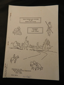
Booklet - Bogong High Plains & Kiewa Valley, Early History & Discovery of the Bogong High Plains & Settlement of the Kiewa Valley, July 1968
A brief history of the area including the Bogong High plains including aborigines and cattlemen. Settlement of the Kiewa Valley including cattlemen and families. A list of the Origin of names of places in the valley.SECV published this booklet using research resources available at the time and using current knowledge with regard to naming of places where the SECV worked and 'created'.Light cardboard cover with 3 staples and with 9 pages printed on one side. Text is boxed. Front cover has 5 simple sketches each of which covers the topics included in the booklet."Dick Puttyfoot" on front coverstate electricity commission of victoria., kiewa hydro electric scheme, kiewa valley, bogong high plains -
 Kiewa Valley Historical Society
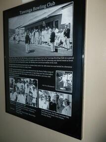
Posters - "Tawonga Remembers" x 7, 2016
The town of Tawonga is in the Kiewa Valley surrounded by farmland. It is adjacent to Mt Beauty (built from 1946), an SECV town built for the workers on the Kiewa Hydro Electric Scheme which was being constructed from 1911 to 1961. Tawonga consisted of essential amenities including a store, school, Butter factory, sporting facilities, post office, hall and hotel. Activities involved sport, social get togethers eg. dances, fund raising, CWA etc.The posters are a collection of historical photos, documentation and information regarding the history of the town of Tawonga, which is the centre of a farming community in the Kiewa Valley. Posters framed with thin black plastic strip, covered by glass. Each one has a title re 'Tawonga Remembers' and includes print and photos. 1. Tawonga Bowling Club 1953 includes 5 B&W photos on black background. 2. Bogong Hotel 4 B&W photos on black background. 3. Bogong Hotel 1970s - 2011 3 B&W photos and 3 coloured photos on black background 4. Tawonga Butter Factory 3 B&W photos on sepia background. 5. Tawonga Store 2 B&W photos on black background. 6. Post Office 3 B&W photos and 1 coloured photo on sepia background. 7. Debutante Balls held in the Hall 2 B&W photos on sepia background.tawonga, photos of early tawonga, kiewa valley, tawonga remembers -
 Kiewa Valley Historical Society
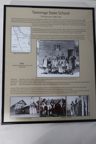
Posters - "Tawonga Remembers" x 5, 2016
The town of Tawonga is in the Kiewa Valley surrounded by farmland. It is adjacent to Mt Beauty (built from 1946), an SECV town built for workers on the SECV's Kiewa Hydro Electric Scheme, which was being constructed from 1911-1961. Tawonga consists of essential amenities including a store, school, post office, butter factory, sporting facilities, hall and hotel. Activities involved sport, social get togethers eg. dances, fund raising, CWA etc.The posters are a collection of historical photos, documentation and information re the history of the town of Tawonga, which is the centre of a farming community in the Kiewa Valley.Posters framed with thin black plastic strip, covered by glass. Each one has a title re "Tawonga Remembers" and includes print and photos in black and white. These have a beige background. 1. Tawonga 1907; 2. Tawonga 1962; 3. Tawonga State School- 1880-1929; 4. Tawonga Primary School -1960; 5. The Beginning of Change: 1930-1970tawonga, photos of early tawonga, kiewa valley, tawonga remembers, tawonga school -
 Kiewa Valley Historical Society
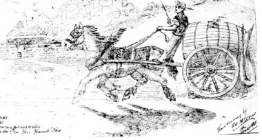
Postcard – Black and white illustration of horse and cart with driver, Circa 1881
Postcard production blossomed in the late 1800s and early 1900s. Postcards were popular because they were a quick and easy way for individuals to communicate with each other and became an efficient method of sharing information and photographs.Postcards provided a glimpse into the lifestyles of the sender which sometimes included a photograph of family or a hand drawn scene as in the accompanying example. As such, they formed part of family history.Black and white printed postcard of a hand drawn single horse cart with driver. Cart is carrying a large wooden barrel with hose attached. Brick homestead building in background. Unwritten on the rear. Handwritten inscription on bottom left of page - How we got our water in the pre Yan Yeanite era Handwritten inscription on bottom right of page – From drawing by G. G. McCrae Christmas 1881 postcard; horse and cart; -
 Kiewa Valley Historical Society
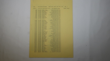
Book - Mt Beauty Voters' Roll, Shire of Bright - Voters' Roll 1979 - Mt Beauty Riding, 1979
Electoral roles list people who are registered and eligible to vote at federal, state, territory and local government elections and referenda. Prior to 1990 the rolls list voters in alphabetical order by surname and first names within each Sub-division of an electoral Division of each State or Territory. The roll is useful and interesting for family historians and the study of demographics.Electoral rolls help to locate the residential address of a person in a particular year or over a period of years. They can be used as a substitute for census records for family historians and the history of a particular place, in this case Mt Beauty. Alex McCullough was a resident of Mt Beauty and Councillor in the Bright Shire. 40 pages of firm blue paper with black typed print on one side only in 'landscape' format. Held by three staples. Each page has columns - numbered 1 to 656; Surnames in alphabetical order; Given names; Occupation; Includes L = 'land'; Address followed by Lot number in the Parish of WermatongOn the cover, top right hand corner "Cr McCullough"shire of bright; mt beauty riding; voters roll; parish of wermatong; alex mccullough -
 Kiewa Valley Historical Society
Book - Kiewa Voters' Roll, Shire of Bright - Voters' Roll 1979 - Kiewa Riding, 1979
Electoral rolls list people who are registered and eligible to vote at federal, state, territory & local government elections and referenda. Prior to 1990 the rolls list voters in alphabetical order by surnames & first names within each Sub division of an electoral division of each State or Territory. The roll is useful & interesting for family historians and the study of demographics. Alex McCullough lived in the Shire of Bright and was on its Council. Electoral roles help to locate the residential address of a person in a particular year or over a period of years. They can be used as a substitute for census records for family historians and the history of a particular place in this case the Kiewa Valley - Tawonga and Tawonga South.Approx. 60 pages of firm yellow paper with black typed print on one side only in 'landscape' format. Held by three staples. Each page has column - numbered 1 to 943; Surnames in alphabetical order; Given names; Occupation; includes L (=land). Address followed by Lot number and parish. Includes Tawonga and Tawonga SouthOn the cover on the right hand side handwritten and difficult to read - "Jack? / Indi / Benambra / Nth Eastern / Division? of Dawson / 123 Victoria Rd. / Melbourne 3000"shire of bright; kiewa riding; voters roll; alex mccullough; tawonga; tawonga south -
 Kiewa Valley Historical Society
Papers - Mt Beauty Voters' Roll, Shire of Bright - Voters' Roll 1985 - Mt Beauty, 4th July 1985
Electoral rolls list people who are registered and eligible to vote at federal, state, territory and local government elections and referenda. Prior to 1990 the rolls list voters in alphabetical order by surnames and first names within each Subdivision of an electoral division of each State or Territory. The roll is useful & interesting for family historians and the study of demographics. Alex McCullough lived in Mt Beauty and was a councillor for the Shire of Bright.Electoral Rolls help to locate the residential address of a person in a particular year or over a period of years. They can be used as a substitute for census records for family historians and the history of a particular place - in this case Mt Beauty.9 pages of firm blue paper with black typed print on one side only. Held at the top left corner with one staple. Each page has columns with 100 people listed up to 864 on page 9. surnames are in alphabetical order followed by given names and then addresses.shire of bright; voters' roll; alex mccullough; mt beauty -
 Kiewa Valley Historical Society
Papers - Kiewa Riding Voters' Roll, Shire of Bright - Voters'Rolls 1985 (May and June) - Kiewa Riding, 4th July 1985
Electoral rolls list people who are registered & eligible to vote at federal, state, territory & local government elections & referenda. Prior to 1990 the rolls list voters in alphabetical order by surname & first names within each subdivision of an electoral division of each state or territory. The roll is useful and interesting for family historians & the study of demographics. Alex McCullough lived in Mt Beauty and was a councillor for the Shire of Bright.Electoral Rolls help to locate the residential address of a person in a particular year or over a period of years. They can be used as a substitute for census records for family historians and the history of a particular place - in this case Tawonga, Tawonga South, Falls CreekMay 1985 is 7 pages; June 1985 is 9 pages of firm yellow paper with black typed print on one side only. Held by one staple at the top left hand corner. The May 1985 - Each page has columns with 100 people listed up to 628 on page 7. Surnames are in alphabetical order followed by given names and then address. June 1985 Voters Roll (Non resident) is created from Property & lists Voters No. (up to 406) Property No. Name (alphabetical) & address and are non resident voters.shire of bright; voters' rolls; kiewa riding; tawonga; tawonga south; alex mccullough; falls creek -
 Kiewa Valley Historical Society
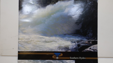
Booklet - Southern Hydro, Southern Hydro
Southern Hydro Ltd. was established in the late 1990s as a result of the disaggregation of the former State Electricity Commission of Victoria. It operates 10 power stations mainly in the north-east of VictoriaSouthern Hydro continued to encourage tourism as did the former State Electricity Commission of Victoria. This brochure is very similar to one previously published by the SECV "Victoria's Hydro Power" except only including those that it operates. Within the KHES the power stations were McKay Creek, Clover and West Kiewa. The change of ownership of hydro power from a government body to private enterprise in the late 1990s is of significant interest to the historian and consumer.Colored photo water spraying onto rocks with black strip across the bottom and logo (4 gold lines forming an "S", a blue triangle with grey cylinder beneath) of Southern Hydro within the strip. Back cover has a similar photo with 4 small photos of men inserted in the black column. This 23 page book gives a history of Southern Hydro and its 10 hydro-electric power stations that it operates. The book lists these and gives a description of each.Top right hand corner of page 5 has a piece of tape stuck over the print with "Page 11 to photo copy & enlarge" secv; khes; mckay creek power station; clover power station; west kiewa power station; mount beauty; rocky valley dam; -
 Kiewa Valley Historical Society
Maps - Bogong x2, Tawonga, Omeo, Dargo, Victoria and others, 1. Bogong Alpine Area; 2. Bogong 8324; 3. Tawonga Topographical; 4. Omeo 8433; 5. Dargo 8323; 6. Victoria State
1. Bogong Alpine Area (outdoor Leisure Map. survey & Mapping Victoria, Government of Victoria, Edition 2, reprinted 1991 with an image of Mt. Feathertop on the front. Information for tourist in the Alpine National Park: Bogong Area. Including: recreational activities, history, weather and vegetation and a list of walks together with locality maps and photographs. The front cover has an image of Mt Feathertop against a blue sky with yellow writing 'Bogong Alpine Area', there is a yellow triangular block on the right hand top corner with black writing 'Outdoor Leisure Map. On the bottom edge is a block of yellow with black writing 'Survey & Mapping Victoria' and a light green map of Victoria with 'VICMSP' printed in white. 2. 8324 Bogong Victoria, Edition 1, Commonwealth of Australia 1981. A topographical Map: 1:100,000 scale (1 cm to 1 KM). Map has a red cover with white writing together with a white block and black writing and a map insert. 3. Tawonga Topographical Map - Forests Commission Victoria, / revised 5/9/77, DEG No. 68-G/399. A Tawonga 803 folded map in a beige colour with the back blank. 4. Omeo 8433 Victoria, Edition 1, Department of Natural Resources. The map has a red and white cover with black writing and a simple map of Australia at the bottom. 5. 8323 Dargo, Edition 1, Commonwealth of Australia. A red and white cover with a map insert. 6. Victoria State Map, Hema Maps, 2002. Hema Maps, State Map, colourful cover with a map of Australia and four tourism photographs. Scale 1: 850,000 An inscription handwritten in blue pen "Trappers Gap to Mitta Mitta 1" to 1 mile". There are some pen markings and notations of tracks.maps, bogong, omeo, tawonga, dargo, victoria, bogong alpine area -
 Kiewa Valley Historical Society
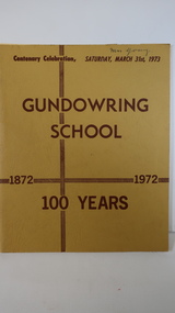
Book - Gundowring x2, Gundowring School 1872 - 1972 100 Years
A school was built in 1871, a shingle roofed wooden building built by the local residents. It was replaced in 1873 with the old school becoming the teacher's residence. The continues with a timeline, a pupil's insight into life at the school, a list of teachers and families. An interesting history of the area and education of the time. Gundowring is a farming town in the Kiewa Valley. The book gives an insight into the education and lifestyle of the time.Mustard cardboard cover with brownish print. Across the top "Centenary Celebration, Saturday, March 31st, 1973". It has 18 pages, some colored, printed on both sides and held together by 2 staples. It includes sketches.Glued inside the front cover "Mr & Mrs Roper & family" - Invitation. Also a newspaper cutting titled "Gundowring"gundowring, education, kiewa valley, school centenary -
 Kiewa Valley Historical Society
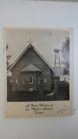
Booklet - St Mark's Church Kiewa x2, A Brief History of St Mark's Church Kiewa written by E. Temple
The Anglican Church at Kiewa. The first stone was laid on the 29th Oct. 1924. In 1879, the Yackandandah rector commenced services on Sundays in private homes in the Kiewa Valley. In 1911 Anglicans met in the Kiewa Methodist Church to elect a committee to organise financial offers and so it eventually became a vestry.The town Kiewa is in the Kiewa Valley. The church served other communities in the Valley. The book records the local populations and their commitment to religion. Cream cardboard cover with a black and white photo of the church on the front cover. It has 4 pages printed on both sides held by 2 staples. Inside there are a few black and white photos. Dated 19741. "Written by E. Temple" handwritten on the front cover 2. "C. Roper" on the front cover and inside the front cover "Clare Roper" Also, "Esther Temple" 's signature on the cover page.st mark's church, kiewa, anglican church, esther teple, thomas mitchell -
 Kiewa Valley Historical Society
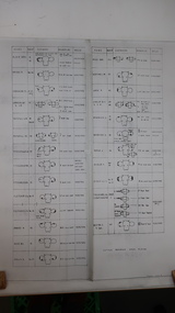
Chart - Cattlemen Families of the Kiewa Valley and their Brands, Cattle Grazing on the Bogong High Plains
Cattle were taken up to the Bogong High Plains by the Kiewa Valley farmers who had a lease there in their allocated area. The cattle roamed and were mustered in late summer. At this time they also sorted the cattle using the cattle's brands for identification.Types of breeds bred in the Kiewa Valley and the names of families who grazed cattle on the Bogong High Plains is of historical interest and also gives an insight into the history of cattle grazing.White paper, black print. Chart's headings: Name of Family (25 in alphabetical order), Run No., Earmark, Brand and Log and Breed. 29th Feb. 1972 cattle grazing, bogong high plains, kiewa valley families, cattle breeds, cattle brands -
 Kiewa Valley Historical Society
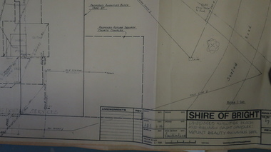
Plans - Mt Beauty Swimming Pool & Amenities Building, Mt Beauty Swimming Pool & Amenities Building by Shire of Bright
Mt Beauty's Swimming Pool was built by Alpine Shire and included a Squash Court. October 1986. Previously the community swam in the West and East Kiewa Rivers. The pool enabled all of the community to swim in a safe area and the opportunity to swim long distances.History of swimming for the Kiewa Valley community and its affect on the following - social, education, and tourism6 large pages of black print on yellowed paper. Dated October 1986 and includes plans for the Mt Beauty Swimming Pool and a Squash Court.On back of the 6th plan in red pen "Roger Sorry Delay / Getting Plans Back / Norm Boden"mt beauty, swimming pool, squash court, shire of bright -
 Kiewa Valley Historical Society
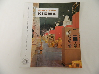
Booklet - S.E.C.V. x2, Power from Kiewa
The State Electricity Commission of Victoria constructed the Kiewa Hydro Electric Scheme. Their public relations employees published booklets to promote the Scheme and the area. In this booklet there are photos of some of the major work constructions with an explanation of how they work and their purpose, a map of the Scheme and an article and photos of tourist facilities and activities that are available.This booklet promotes the Kiewa Hydro Electric Scheme and tourism indicating that tourism was recognised as a new industry for the area. The photos give a pictorial history of the area eg. skiing using the Summit T-bar lift and includes the facilities available at the time. The explanation of the Kiewa Hydro Electric Scheme is a basic resource for students interested in Hydro power.Slim booklet with photo of McKay Creek Power Station on the front cover and the title in brown and black at the top. Printed along the spine is State Electricity Commission of Victoria.state electricity commission of victoria. kiewa hydro electric scheme. tourism. t-bar ski tow. falls creek -
 Kiewa Valley Historical Society
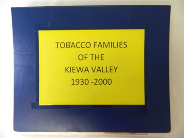
Folder - Tobacco Families of the Kiewa Valley 1930-2000
Tobacco was grown in the Kiewa Valley mainly by Italian families. The stories and photos in this folder give a history of the tobacco industry in the Kiewa Valley and also of the migrants that settled in the valley.Blue plastic A3 size folder with bright yellow paper attached to the front cover with the title printed in black. Enclosed in clear plastic sleeves are photos and descriptions of families of the Kiewa Valley who grew tobacco.tobacco. italian people. migrants. farming. kiewa valley. -
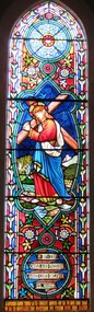 Christ Church Anglican Parish of Warrnambool
Memorial window: William RUTLEDGE, "BY THY CROSS AND PASSION GOOD LORD DELIVER US""
William Rutledge [born 1806, Ireland] was a self-made, larger-than-life man who involved himself prominently in business, municipal, political, community and social aspects of life. Eldest son of James and Martha [nee Forster], William arrived in Australia from Ireland in 1829 and within six years had sufficiently established himself to purchase land in New South Wales. He married Eliza Kirk in Sydney in august 1840. They had two sons and five daughters. In 1843 he began his association and life in Port Fairy and soon became prominent and influential in almost all aspects of that developing town. His interests encompassed mercantile, civic, pastoral, shipping, importing, exporting, immigration, politics and social aspects with in the district and colony. He was a major contributor to the building of St John’s Anglican Church, Port Fairy. He acquired three special surveys with historical importance in Victoria. In south west Victoria that interest being especially the Farnham Survey of 5120 acres between Dennington and Tower Hill/Killarney. This was farmed by immigrant tenant and lessee farmers, some of whom were brought to the Australia at William Rutledge’s own expense and by whom he was considered a kind and considerate landlord. His endeavours were not without failures and in 1862 his Port Fairy Company failed with debts of over £170,000. This debt was redeemed in full within a year. According to reported accounts, William Rutledge had a tempestuous manner with an “explosive” temper, although he did not hold grudges. This is countered by accounts of his kindness, generosity, honesty and practical, progressive outlook in all his undertakings. After the failure and closure of his Company, William Rutledge moved to his property at Farnham Park near Warrnambool where he concentrated his interest in breeding sheep and horses. Throughout his life his home was reputed to be convivial and hospitable. William Rutledge died at Farnham Park on June 1st, 1876. William Rutledge's place in the history of settlement in south west Victoria gives importance to this memorial.Stained glass window, south wall, main nave, depicting Jesus bearing the Cross. The background is quite floral. A medallion shape holds the title as printed on a ribbon: "By thy cross and passion good Lord deliver us".In Latin: In Memoriam Gulielmi Rutledge qui A.D. MDCCCVI underimo ante Kal: Feb: natus vitam posuit/ Kal: Jun: MDCCCLXXVI Filae amantissimae hanc fenestram pietatis indirio posueruntrutledge, william rutledge, farnham survey, port fairy, christ church warrnambool -
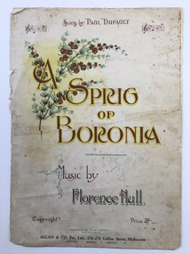 Warrnambool and District Historical Society Inc.
Leisure object - Sheet music, A sprig of boronia, 1916
This is an early 20th century musical composition by a leading Tasmanian composer, Florence Hull (Mrs Arthur Kenny). It is a sentimental song as the ‘sprig of boronia’ is a withered one, kept as a relic of some past event. This music was printed in the Victorian School Paper for Grades 7 and 8 in 1918 and the proceeds of copies of one of the editions of this work were donated to the Hawthorn Red Cross in Melbourne. Florence Hull’s musical works and memoirs are in the Tasmanian Archives. Paul Dufault, who sang this song, was a leading Canadian tenor who toured Australia and Europe. He died in 1930 aged 57. This sheet music has significance as it was composed by a Tasmanian woman in the early 20th century and it represents the type of music popular in concert halls at the time. It has been in the Warrnambool and District Historical Society collection for many years. This is a four page piece of sheet music (cover plus two pages of music). The paper is cream-coloured, discoloured in places, with brown print on the back of the cover and black notation on the music pages. The front cover is in brown, yellow and green tonings, with a chromolithographic illustration of a Boronia flower spray and some music bars. The back of the cover has information on eight of Florence Hull’s other compositions with comments by critics. The pages have been torn and mended with adhesive tape.Front Cover: ‘Sung by Paul Dufault’ ‘A Sprig of Boronia’ ‘Music by Florence Hull’ ‘Copyright, Price 2/- nett, Published by F. M. Kenny, Melbourne, Allan and Co. Pty. Ltd., 276-278 Collins Street, Melbourne, Adelaide, Bendigo, Geelong’ In pencil on front cover: ‘To Mac from ….., 25/8/24’ florence hull, paul dufault, warrnambool, a sprig of boronia sheet music, sheet music, warrnambool history -
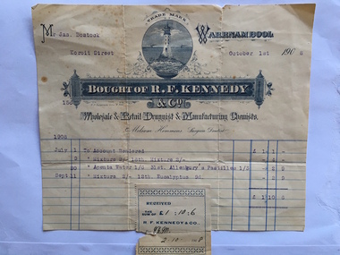 Warrnambool and District Historical Society Inc.
Docket, R F Kennedy, 1908
James Bostock, a grazier, was a member of the Bostock family, prominent Warrnambool pastoralists and businessmen who had come from Tasmania in the mid 1840s and settled in the Warrnambool area. The chemist shop of R.F. Kennedy was established in Warrnambool in 1880 and quickly became one of the leading businesses in the town. Kennedy was a wholesale, retail and manufacturing chemist in Timor Street (the building still exists) and a prominent community member and a Town Councillor. He died in 1903 but the business continued to use the name of R. F. Kennedy and Co. until 1924. This docket is of some interest as it contains the names of the R.F. Kennedy chemist shop and James Bostock , a prominent Warrnambool resident. This is a cream-coloured docket issued by R.F.Kennedy & Co. to James Bostock in 1908. The printing shows a variety of styles in blue and white and the page has blue printed lines. The famous Kennedy symbol of a lighthouse is printed prominently and the name of Kennedy is contained in an ornamental banner. The sales information is printed in blue type and there is a Kennedy stamp attached to the bottom of the docket and this is slightly overlapping the page. There is a small tear in the stamp and at the top of the docket. ‘Mr Jas. Bostock, Koroit Street, October 1st 1908, July 1st , To Account Rendered, £1/1/-, July 9, Mixture 2/-, 18th, Mixture, 2/-, 4/-, July 30, Apenta Water, 1/6, 31st Allenbury’s pastilles, 1/3, 2/9, Sept. 11, Mixture 2/-, 12th, Eucalyptus, 9d., 2/9, Total, £1/10/6’r.f. kennedy, james bostock, r f kennedy chemist, warrnambool history -
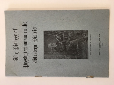 Warrnambool and District Historical Society Inc.
Book, The Pioneer of Presbyterianism in Western Victoria, 1947
This booklet was written by the Rev. H Clark of Terang in 1947 and gives the details of the life and work of the Rev. William Hamilton who came to Kilnoorat in 1847 and was the pioneer Presbyterian minister in the Western District.This is an important little biography of a a pioneering Presbyterian minister in the Western District.This a soft covered booklet of eight pages. It has a grey cover with black print and a photograph of a bearded gentleman reading a book. This book has been stapled but the staples are removed.The Pioneer of Presbyterianism in the Western District. Rev. William Hamilton.presbyterianism history -
 Warrnambool and District Historical Society Inc.
Book, Maunder's Treasury of Knowledge, 1893
This book was a present from James Dickson to John Glass Cramond in 1897. These two men were business partners and friends. They established the drapery, ironmongery and clothing business of Cramond and Dickson in Warrnambool in 1855 and this business remained as an important store in Warrnambool until 1973. John Cramond was Mayor of Warrnambool from 1876 to 1877 and from 1881 to 1882.This is a most significant item as it belonged to a prominent Warrnambool man and was given to him by another prominent Warrnambool citizen. The store of Cramond and Dickson was one of the best-known and most important shop in Warrnambool for nearly 120 years. This is a brown leather-bound book with a red lining on the inside cover. The book has 900 pages and was printed in 1893. The contents include an English Grammar, an English Dictionary, the population of European Capitals, a list of Cities and Towns in Britain, a list of Animal, Vegetable and Mineral productions, a list of Proverbs, a Law Dictionary, a Compendium of Modern History and the Coronets of Princes of the Blood and of the Peerage. The printed material has two columns per page. The cover is somewhat scuffed and the red lined-page is ragged (silverfish damage?).‘Mr J.G. Cramond from James Dickson, 5 May 1897’ Warrnambool and District Historical Society stamp , W.B. 124 john glass, cramond james dickson -
 Warrnambool and District Historical Society Inc.
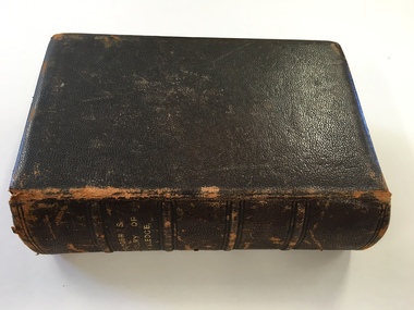
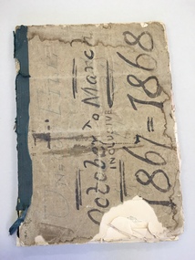
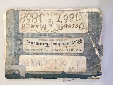
Newspaper, Warrnambool Examiner 1/10/1867-31/3/68, 1867,1868
The Warrnambool Examiner was founded by John Wilkinson and Richard Osburne in 1851. After a gap of a couple of years Richard Osburne resumed publication in October 1853 and continued until October 1867. William Fairfax and Henry Laurie then leased the paper (1867 to 1872) before Richard Osburne again became the proprietor from October 1872 to April 1878 and from December 1879 to December 1880 when publication ceased. Richard Osburne was a pioneer settler in Warrnambool, arriving in 1847. He was prominent in community activities in the town and was a most important early historian, publishing his seminal work, ‘The History of Warrnambool’ in 1887, using the Warrnambool Examiner newspapers to assist with this history. Fairfax and Laurie were the proprietors when these papers were printed. William Fairfax was a member of the Fairfax family that were, and still are, associated with the publication of many Australian newspapers and Henry Laurie later became well-known as a Melbourne University Philosophy Professor. These original newspapers are most important because they contain much information on Warrnambool’s early history and are a primary source for historians. These papers are also of importance to historians today as some parts of these newspapers were not filmed and are not currently available on microfilm. These papers were in a Warrnambool City Council storage area and it is surmised that they have come from the old Warrnambool Museum which no longer exists.These are the original Warrnambool Examiner newspapers from 1st October 1867 to 31st March 1868. They are bound with a tattered cardboard cover, dark blue binding and string. These broadsheet papers are of two pages printed back to back and were published on Tuesdays and Fridays. They are unmarked and generally in good condition but there are some torn pages. There is one loose page. warrnambool examiner, richard osburne, william fairfax, henry laurie, warrnambool -
 Warrnambool and District Historical Society Inc.
News Sheet, Warrnambool Examiner 1/10/67 - 31/12/67 : 3/1/68 - 31/3/1868, 1867-8
The Warrnambool Examiner was founded by John Wilkinson and Richard Osburne in 1851. After a gap of a couple of years Richard Osburne resumed publication In October 1853 and continued until October 1867. William Fairfax and Henry Laurie then leased the paper (1867 to 1872) before Richard Osburne again became the proprietor from October 1872 to April 1878 and from December 1870 to December 1880 when publication ceased. Richard Osburne was a pioneer settler in Warrnambool, arriving in 1847. He was prominent in community activities in the town and was a most important early historian, publishing his seminal work, ‘The History of Warrnambool’ in 1887, using the Warrnambool Examiner newspapers to assist with this history. Fairfax and Laurie were the proprietors when these papers were printed. William Fairfax was a member of the Fairfax family that were, and still are, associated with the publication of many Australian newspapers and Henry Laurie later became well-known as a Melbourne University Philosophy Professor. These original newspapers are most important because they contain much information on Warrnambool’s early history and are a primary source for historians. These papers are also of importance today as some parts of these papers were not filmed and are not currently available on microfilm. These papers were in a Warrnambool City Council storage area and it is surmised that they have come from the old Warrnambool Museum which no longer exists.These are two sets of original Warrnambool Examiner newspapers (1st October 1867 to 31st December 1867 and 3rd January 1868 to 31st March 1868), bound with cardboard, dark blue binding and string. There are six loose pages in front of the first bound set. These are broadsheets of two pages printed back and front. The papers are heavily marked with red and blue pencil and are marked, ‘private copy, F.& L.’ indicating that they are the copies the proprietors, Henry Laurie and William Fairfax, used to annotate the papers for the next edition. The pages are in good condition with some ragged edges. ‘F & L’ ‘Private copy’ warrnambool examiner, henry laurie, william fairfax, richard osburne -
 Warrnambool and District Historical Society Inc.
News Sheet, Warrnambool Examiner 12/11/1867 - 28/1/1868, 1867, 1868
The Warrnambool Examiner was founded by John Wilkinson and Richard Osburne in 1851. After a gap of a couple of years Richard Osburne resumed publication in October 1853 and continued until 1867. William Fairfax and Henry Laurie then leased the paper (1867 to 1872) before Richard Osburne again became the proprietor from October 1872 to April 1878 and from December 1879 to December 1880 when publication ceased. Richard Osburne was a pioneer settler in Warrnambool, arriving in 1847. He was prominent in community activities in the town and was a most important early historian, publishing his seminal work, ‘The History Of Warrnambool’ in 1887, using the Warrnambool Examiner newspapers to assist with this history. Fairfax and Laurie were the proprietors when the papers herein described were printed. William Fairfax was a member of the Fairfax family that was , and still are, associated with the publication of many Australian newspapers and Henry Laurie later became well-known as a Melbourne University Philosophy Professor.These original newspapers are most important because they contain much information on Warrnambool’s early history and are a primary source for historians. These papers are also of importance because some parts of these papers were not filmed and are not currently available in microfilm. These papers were in a Warrnanmbool City Council storage area and it is surmised that they have come from the old Warrnambool Museum which no longer exists. These are original copies of the Warrnambool Examiner newspapers from 12th November 1867 to 28th January 1868. They are broadsheets printed twice a week with two pages containing four pages of printing for each edition. They are unbound and contained in two pieces of plain cardboard. They are unmarked and in good condition.warrnambool examiner, richard osburne, henry laurie, william fairfax -
 Warrnambool and District Historical Society Inc.
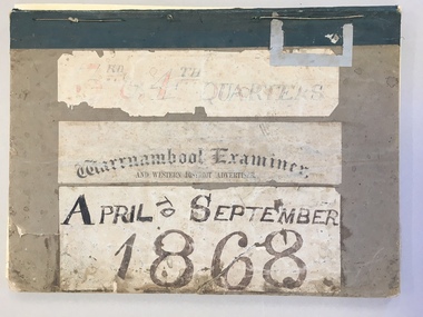
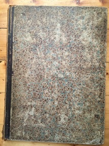
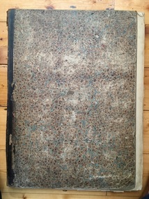
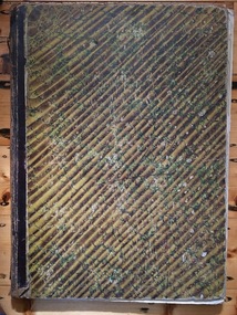
News Sheet, Warrnambool Examiner 3/4/1868 - 29/9/1868, 1868
The Warrnambool Examiner was founded by John Wilkinson and Richard Osburne in 1851. After a gap of a couple of years Richard Osburne resumed publication in October 1853 and continued until 1867. William Fairfax and Henry Laurie then leased the paper (1867 to 1872) before Richard Osburne again became the proprietor from October 1872 to April 1878 and from December 1879 to December 1880 when publication ceased. Richard Osburne was a pioneer settler in Warrnambool, arriving in 1847. He was prominent in community activities in the town and was a most important early historian, publishing his seminal work, ‘The History of Warrnambool’ in 1887, using the Warrnambool Examiner newspapers to assist with the history. Fairfax and Laurie were the proprietors when the papers describe herein were printed. William Fairfax was a member of the Fairfax family which were, and still are, associated with the publication of many Australian newspapers. Henry Laurie later became well-known as a Melbourne University Philosophy Professor.These original newspapers are most important because they contain much information on Warrnambool’s early history and are a primary source for historians. These papers are also of importance because some parts of these papers were not filmed and are not currently available on microfilm. These papers were in a Warrnambool City Council storage area and it is surmised that they have come from the old Warrnambool Museum which no longer exists. These are original copies of the Warrnambool Examiner newspapers from 3rd April 1868 to 29th September 1868 inclusive (two copies of each). They are broadsheets of two pages per newspaper printed on the four sides. Both sets are bound with plain cardboard folders, green binding and string. One set cover is broken and this set is unmarked and a bit crumpled. The other set is marked with the editor’s red and blue pencil marks but otherwise the papers are in good condition.warrnambool examiner, richard osburne, henry laurie -
 Warrnambool and District Historical Society Inc.
News Sheet, Newspaper Warrnambool Examiner, 1868,1869
The Warrnambool Examiner was founded by John Wilkinson and Richard Osburne in 1851. After a gap of a couple of years Richard Osburne resumed publication in October 1853 and continued until 1867. William Fairfax and Henry Laurie then leased the paper (1867 to 1872) before Richard Osburne again became the proprietor from October 1872 to April 1878 and from December 1879 to December 1880 when publication ceased. Richard Osburne was a pioneer settler in Warrnambool, arriving in 1847. He was prominent in community activities in the town and was a most important early historian, publishing his seminal work, ‘The History of Warrnambool’ in 1887, using the Warrnambool Examiner newspapers to assist with this history. Fairfax and Laurie were the proprietors when the papers described herein were printed. William Fairfax was a member of the Fairfax family that was, and still is, associated with the publication of many Australian newspapers. Henry Laurie later became well-known as a Melbourne University Philosophy Professor. These original newspapers are most important because they contain much information on Warrnambool’s early history and are a primary source for historians. These papers are also of importance because some parts of these papers were not filmed and are not currently available on microfilm. These papers were in a Warrnambool City Council storage area and it is surmised that they have come from the old Warrnambool Museum which no longer exists. These are original copies of the Warrnambool Examiner newspapers from October 2nd 1868 to 30th March 1869. They are in two bound volumes (October 2nd 1868 to December 29th 1868 and January 1st 1869 to March 30th 1869). The volumes are contained in plain cardboard with green binding and string. The newspapers are broadsheets of two pages with printing on four sides. The papers are marked with the blue and red pencil markings used by the editor. warrnambool examiner, richard osburne, william fairfax, henry laurie -
 Warrnambool and District Historical Society Inc.
News Sheet, Newspapers Warrnambool Examiner, 1869
The Warrnambool Examiner was founded by John Wilkinson and Richard Osburne in 1851. After a gap of a couple of years Richard Osburne resumed publication in October 1853 and continued until 1867. William Fairfax and Henry Laurie then leased the paper (1867 to 1872) before Richard Osburne again became the proprietor from October 1872 to April 1878 and from December 1879 to December 1880 when publication ceased. Richard Osburne was a pioneer settler in Warrnambool, arriving in 1847. He was prominent in community activities in the town and was a most important early historian, publishing his seminal work, ‘The History of Warrnambool’ in 1887, using the Warrnambool Examiner newspapers to assist with this history. Fairfax and Laurie were the proprietors when the papers described herein were printed. William Fairfax was a member of the Fairfax family that was, and still is, associated with the publication of many Australian newspapers. Henry Laurie later became well-known as a Melbourne University Philosophy Professor.These original newspapers are most important because they contain much information on Warrnambool’s early history and are a primary source for historians. These papers are also of importance because some parts of these papers were not filmed and are not currently available on microfilm. These papers have come from the old Warrnambool Museum which no longer exists.These are original copies of the Warrnambool Examiner from 5th January 1869 to 31st December 1869. They are bound and have a mottled brown/blue cover with brown binding glued together. Some of the pages have torn edges but otherwise are in good condition. The pages are unmarked. The paper of 6th August 1869 has an insert advertisement for Wilkie, Webster and Allan Pianofortes with Mr Fanner the Warrnambool representative. The newspapers are broadsheet, two pages to one edition printed on both sides and published twice weekly. Inside front cover (handwritten): ‘Fairfax and Laurie’warrnambool examiner, richard osburne, william fairfax -
 Warrnambool and District Historical Society Inc.
News Sheet, Newspaper Warrnambool Examiner, 1869
The Warrnambool Examiner was founded by John Wilkinson and Richard Osburne in 1851. After a gap of a couple of years Richard Osburne resumed publication in October 1853 and continued until 1867. William Fairfax and Henry Laurie then leased the paper (1867 to 1872) before Richard Osburne again became the proprietor from October 1872 to April 1878 and from December 1879 to December 1880 when publication ceased. Richard Osburne was a pioneer settler in Warrnambool arriving in 1847. He was prominent in community activities in the town and was a most important early historian, publishing his seminal work, ‘The History of Warrnambool’ in 1887, using the Warrnambool Examiner papers to assist with this history. Fairfax and Laurie were the proprietors when the papers described herein were printed. William Fairfax was a member of the Fairfax family that was, and still is, associated with the publication of many Australian newspapers. Henry Laurie later became well-known as a Melbourne University Philosophy ProfessorThese original newspapers are most important because they contain much information on Warrnambool’s early history and are a primary source for historians. These papers are also of importance because some parts of these papers were not filmed and are not currently available on microfilm. These papers were in a Warrnambool City Council storage area and it is surmised they have come from the old Warrnambool Museum which no longer exists. These are original copies of the Warrnambool Examiner newspapers from 8th January 1869 to 31st December 1869. They are broadsheet pages, two per newspaper, printed on the four pages and bound together and published twice weekly. The cover is a mottled brown and green colour and it has brown binding glued together. The pages are unmarked and the papers are in good condition but the last few pages are heavily foxed. warrnambool examiner, richard osburne, william fairfax -
 Warrnambool and District Historical Society Inc.
News Sheet, Newspaper Examiner, 1869
The Warrnambool Examiner was founded by John Wilkinson and Richard Osburne in 1851. After a gap of a couple of years Richard Osburne resumed publication in October 1853 and continued until 1867. William Fairfax and Henry Laurie then leased the paper (1867 to 1872) before Richard Osburne again became the proprietor from October 1872 to April 1878 and from December 1879 to December 1880 when publication ceased. Richard Osburne was a pioneer settler in Warrnambool, arriving in 1847. He was prominent in community activities in the town and was a most important early historian, publishing his seminal work, ‘The History of Warrnambool’ in 1887, using the Warrnambool Examiner newspapers to assist with this history. Fairfax and Laurie were the proprietors when the papers described herein were printed. William Fairfax was a member of the Fairfax family that was, and still is, associated with the publication of many Australian newspapers. Henry Laurie later became well-known as a Melbourne University Philosophy Professor.These original newspapers are most important because they contain much information on Warrnambool’s early history and are a primary source for historians. These papers are also of importance because some parts of these papers were not filmed and are not currently available on microfilm. These papers were in a Warrnambool City Council storage area and it is surmised that they have come from the old Warrnambool Museum which no longer exists.These are original copies of the Warrnambool Examiner from 2nd April 1869 to 28th September 1869. The papers are two pages of broadsheet, printed on the four sides, published twice a week and occasionally containing a Supplement sheet. The cover is plain cardboard with grey binding held together by glue. The cover is torn and the pages have many torn edges and are tattered in places. The pages (advertisements and public notices) have been marked in blue and red pencil by an editor.Inside front cover: ‘1869 April to September’warrnambool examiner, richard osburne, william fairfax, henry laurie