Showing 13708 items
matching wye-river-bridge
-
 Wodonga & District Historical Society Inc
Album - Ringer's River by Des Martin - Plate 14 - O'Day visits the O'Hara's homestead
Daylight O'Day swims the river alone and, instead of going straight back to Gooloora, rides up-river a little to call at O'Hara's slab homestead where he is given a very warm welcome by young Erin O'Hara. Ellen Tenteye as Erin O'Hara.The album and images are significant because they document literature written by a prominent member of the Wodonga community. The presentation of this precis was supported by several significant district families and individuals.Ringer's River Album Coloured photo Plate 14des martin, many a mile, ringer's river, northeast victoria stories -
 Stawell Historical Society Inc
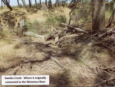
Photograph, Swedes Creek where it originally connected to the Wimmera River 2017
Swedes Creek where it originally connected to the Wimmera River. 2017.Coloured photograph of a disturbed timber area.Swedes Creek - Where it originally connected to the Wimmera River.water -
 Federation University Historical Collection
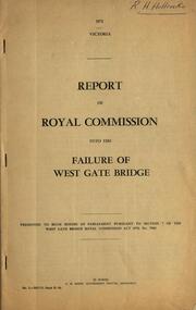
Book - Report, Report of Royal Commission into the Failure of West Gate Bridge, 1971, 1971
.1) Foolscap soft brown covered report on the failure of the Westgate Bridge over the Yarra River. .2) Document relatng to the collapse of the Westgate Bridgewestgate bridge, bridges, royal commission, c.h. rixon, west gate, engineering -
 Greensborough Historical Society
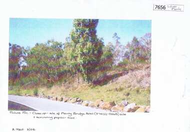
Photograph - Photograph (Copy), Anne Paul, Plenty Bridge Hotel site, 2003_03
21st century photograph of heritage site: former Plenty bridge Hotel and Tollhouse, situated on the eastern side of Old Lower Plenty Road, near the Old Lower Plenty Road Bridge on the east bank of the Plenty River. Although the Hotel burnt down, poplar trees still exist on the site.3 pages, 1 x colour photograph printed on paper, 1 x Heritage Inventory (text) and 1 historic black and white photo.On colour photograph: Close-up site of Plenty Bridge Hotel (H7922-0265) and surviving poplar tree. A. Paul 3/03plenty bridge hotel, lower plenty, plenty river -
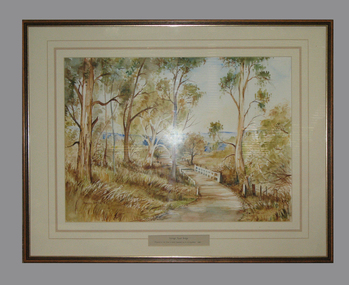 South Gippsland Shire Council
Framed watercolour painted by Bianca Biesuz, "Dryings Road Bridge", 1987
Painted by Bianca BiesuzCream card window mount with pink edging lines. Text panel cut out lower edge. Brown wood frame with gold edging. Painting portrays trees with a pathway through them, white bridge,"Dryings Road Bridge" -
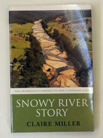 Orbost & District Historical Society
book, Snowy River Story, April 2005
This book recounts the story of the campaign by Dalgety and Orbost to restore water to the Snowy River. Claire Miller is a senior journalist for The Age newspaper with a special interest in the environment. She has covered this campaign since 1999.This book recounts the story of the campaign by Dalgety and Orbost to restore water to the Snowy River. It is significant to this collection as many of the current residents of Orbost were involved in the campaign.A 270pp paperback book titled Snowy River Story written by Claire Miller. On the front cover is a coloured photograph of the Snowy River at Bete Bolong. It documents the story of the campaign to save the Snowy River.snowy-river snowy-mountains-hydro-electric-scheme environmental -
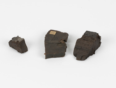 The Beechworth Burke Museum
Geological specimen - Coorongite
Coorongite is a dark, rubber-like, highly resilient structureless algal deposit. In the Coorong district of South Australia it occurs in moderate quantities associated with the coastal swamps and sand dunes which extend for a considerable distance east of the mouth of the Murray. This particular specimen was recovered from the south of the Coorong River, South Australia. A type of sediment rich in organic matter, Coorongite is the unlithified end-member of the sapropelic coal series. The members of the sapropelic coal series can be ranked in order as sapropel (the unlithified form), sapropelic-lignite, and sapropelic-coal (the lithified forms) based on increasing carbon content and decreasing volatile content. Sapropel (Coorongite) is an unlithified dark, pulpy, fine organic mud containing concentrations of algae and miospores that are more or less identifiable. Coorongite is typically found as an algae like substance, that can be found in irregular size pieces. Coorongite was believed to be dried up oil due to its rubber-like texture. The Coorongite is also soft to the point where it can be cut into with a knife or it can be broken and torn by hand. Otherwise known as 'Kurangk', the Coorong River is home to the Ngarrindjeri people, which acts as both a place for gathering food and a spiritual place. In 1852 the first sight of Coorongite was found along the Coorong River. The finders mistook the Coorongite for dried up oil, which lead to the belief that there were oil reserves under the Coorong River. Between the 1860s and the 1930s the Coorong River became a place where mining oil and Coorongite became precedent. Nowadays, the local council and the South Australian Government are working together with the Ngarrindjeri people to sustain and preserve the Coorong River and the culture that is with it. Soon after gold was discovered in 1851, Victoria’s Governor La Trobe wrote to the Colonial Office in London, urging ‘the propriety of selecting and appointing as Mineral Surveyor for this Colony a gentleman possessed of the requisite qualifications and acquaintance with geological science and phenomena’. Alfred Selwyn was appointed geological surveyor in Australia in 1852 which began the Geological Survey of Victoria. Selwyn went on to collect geological samples and catalogue thousands of specimens around Australia. In 1853-69 the Geological Survey issued under Selwyn's direction sixty-one geological maps and numerous reports; they were of such high standard that a writer in the Quarterly Journal of the Geological Society of London bracketed the survey with that of the United States of America as the best in the world. During his years spent in Australia, Selwyn collected numerous significant geological specimens, examples of which are held in collections such as the Burke Museum.Coorongite is considered to be a mineral with a unique texture, where it can be both hard and soft. Coorongite can also be considered to be a rare mineral, as it is only located along the Coorong River and due to the mining of it, has left very few sources. It was believed at one point that Coorongite could be used to replace oil. This specimen is part of a larger collection of geological and mineral specimens collected from around Australia (and some parts of the world) and donated to the Burke Museum between 1868-1880. A large percentage of these specimens were collected in Victoria as part of the Geological Survey of Victoria that begun in 1852 (in response to the Gold Rush) to study and map the geology of Victoria. Collecting geological specimens was an important part of mapping and understanding the scientific makeup of the earth. Many of these specimens were sent to research and collecting organisations across Australia, including the Burke Museum, to educate and encourage further study.Three solid varyingly hand-sized pieces of wooden appearing organic matter derived from the river in the Coorong District in South Australia. A rubber-like, highly resilient structureless algal deposit.Specimen 245 page 69 / in Descriptive Register / "Elcestic Bitumen, / Coorangite" South of / Coorung River, South Australia . / C. WIllman / 15/4/21burke museum, beechwoth, indigo shire, beechworth museum, geological, geological specimen, mineraology, coorong, coorong river, kurangk, ngarrindjeri, south australia, coorongite, coorongite specimen -
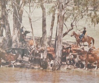 Wodonga & District Historical Society Inc
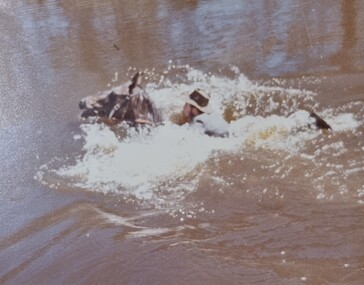
Album - Ringer's River by Des Martin - Plate 21 - Swimming cattle across to Victoria
But O'Day, the general, has chosen this particular time to ride up river and meet a mob of cattle that Charlie Clowes is bringing down for him from Camoola. In the first of many such successful operations the cattle are swum across to Victoria at the point where O'Day's run, Brightons, comes down to the river.The album and images are significant because they document literature written by a prominent member of the Wodonga community. The presentation of this precis was supported by several significant district families and individuals.Ringer's River Album Coloured photo Plate 21des martin, many a mile, ringer's river, northeast victoria stories -
 Linton and District Historical Society Inc
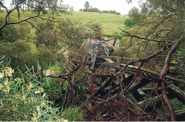
Photograph, Dilapidated bridge over Springdallah Creek, Happy Valley/Piggoreet, 2010
Already in a dilapidated condition, the bridge was further damaged by storms and floodwaters in 2010 and 2011. In 2025, little remains of the old bridge.Colour photograph showing damage to the Old Springdallah Bridge - a trestle bridge spanning Springdallah Creek, on Linton-Piggoreet Road. trestle bridges, old springdallah bridge -
 Orbost & District Historical Society
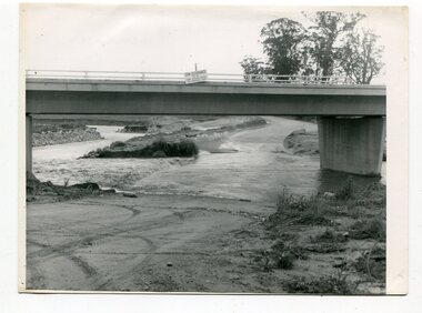
black and white photographs, October 22 1976
The road to Marlo was cut by flood waters from the Snowy River in two places. The road was closed when water flowed over Gilbert's Gulch (3243.1) The Snowy River broke its banks and flooded surrounding Orbost, Marlo, Lochend and Jarrahmond were isolated. The river bank at the bridge site was broken and filled with earth and rock fill. (3243.2) The new Snowy River Bridge was nearing completion when the river rose 7.2 metres causing erosion on the eastern bank. (3243.7) Contractors involved in the construction of the Princes Freeway and bridge were delayed by the flood waters. (3243.8) The 1976 flood at Orbost was a significant event which delayed the construction of the current Snowy River Road Bridge.These photographs record that event.Nine black / white photographs of flood waters across roads. orbost-flood-1976 snowy-river-bridge marlo-road-flood-1976 gilbert;s-gulch-flood -
 Lakes Entrance Historical Society
Photograph - North Arm bridge Lakes Entrance Victoria, M Fish, 1970 c
concrete bridge over North Arm taken from Eastern side of bridge southern shore of North Arm Lakes Entrance Victoria. Bridge built 1916 to 1917 demolished after opening of new bridgeColour photograph of concrete bridge over North Arm taken from Eastern side of bridge southern shore of North Arm Lakes Entrance Victoriabridges, topography -
 Greensborough Historical Society
Photographs, Plenty River Flood 1974, 1974_05
Five photographs of the Plenty River in flood 1974, taken around Greensborough by June and Brian Roberts.Five photographs b & w; one note with #3#1: Plenty River may '74 flood. Flintoff St. bridge wrecked #2: [Unmarked]? #3: Plenty at Greensborough1974 flood (Note: "The house on left hand side of the picture - would it be the Medical/dental #4: Rand St. foot bridge remnants (Plenty R.) May '74 #5: Debris dumped on park by Plenty R. flood May 1974 floods, plenty river -
 Wodonga & District Historical Society Inc
Album - Ringer's River by Des Martin - Plate 29 - Keiran drowns
A flash flood caused by the cloudburst upstream catches them all in the river and Keiran is drowned.The album and images are significant because they document literature written by a prominent member of the Wodonga community. The presentation of this precis was supported by several significant district families and individuals.Ringer's River Album Coloured photo Plate 29des martin, many a mile, ringer's river, northeast victoria stories -
 Anglesea and District Historical Society
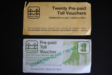
Toll Vouchers, West Gate Bridge Authority, Estimated 1980
6 x Pre-paid Toll Vouchers valid for commuter class 1 vehicle only. Valid for one crossing of the West Gate Bridge. 1 x Cover (yellow) - Twenty Pre-paid Toll Vouchers. Commuter Class 1 Vehicle Only. For Re-order please contact Toll Officer on Manned Lanes. This doument serves as a receipt for payment hereof - $12.00.Pre-paid / Toll Vouchers / COMMUTER CLASS 1 VEHICLE ONLY / West Gate Bridge / Re-order - P.O. Box 127, Port Melbourne 3207 Phone 645 1599. West Gate Bridge symbol. toll, pre-paid voucher, melbourne, transport freeways, road bridges, west gate -
 Marysville & District Historical Society
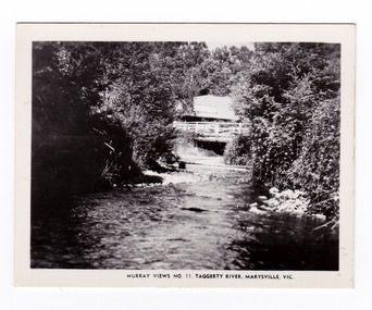
Photograph (item) - Black and white photograph, Murray Views, Murray Views No. 11. Taggerty River, Marysville, Vic, Post 1929
An early black and white photograph of the Steavenson River in Marysville, Victoria.An early black and white photograph of the Steavenson River in Marysville, Victoria. The Steavenson Falls is named after the Victorian Assistant Commissioner of Roads and Bridges, John Steavenson who arrived here in the early 1860s. This photograph was published by Murray Views in Gympie, Queensland, as a souvenir of Marysville.marysville, victoria, photograph, murray views, souvenir, steavenson river, john steavenson -
 Marysville & District Historical Society
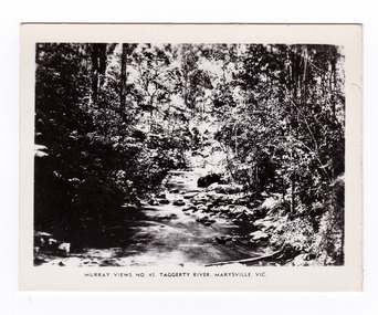
Photograph (item) - Black and white photograph, Murray Views, Murray Views No. 45. Taggerty River, Marysville, Vic, Post 1929
An early black and white photograph of the Taggerty River in Marysville, Victoria. An early black and white photograph of the Taggerty River in Marysville, Victoria. This photograph was produced by Murray Views in Gympie, Queensland as a souvenir of Marysville.taggerty river, marysville, victoria, murray views, photograph, souvenir -
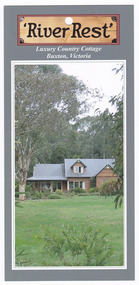 Marysville & District Historical Society
Flyer (item) - Accommodation flyer, 'River Rest', Unknown
An information flyer regarding accommodation at River Rest cottage in Buxton.An information flyer regarding accommodation at River Rest cottage in Buxton.buxton, victoria, australia, river rest country cottage, accommodation, flyer -
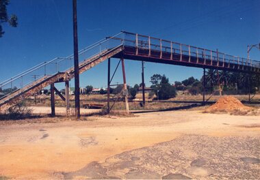 Stawell Historical Society Inc
Photograph, Railway Step Bridge Stawell
Railway Step Bridge StawellTwo (2) Colour Photgraphs of a Pedestrian Bridge across Railway Tracks. One showing the bridge in the mid distance, with a mound of soil in front. The Second looking across the bridge, with houses in the distancestawell, railway -
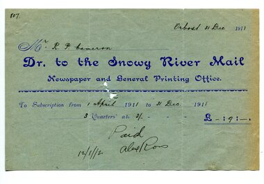 Orbost & District Historical Society
account, 12.12.1912
Previously published as The Snowy River mail and Tambo and Croajingolong gazette from 1890 to 1911. The Gippsland Courier merged with the Snowy River Mail when proprietor Lachlan Ross moved to Orbost in 1910. In 1999 the paper was acquired by the Yeates family when the Hollins family retired from the newspapers business. The paper is still being produced by the fourth generation of the Yeates family as part of East Gippsland Newspapers. They also produce the Bairnsdale Advertiser, the East Gippsland News and the Lakes Post and the yearly publications East Gippsland Visitor Guide and the Great Alpine Road Touring Guide. Robert Pullar Cameron was a Shire Councillor for many years. He married Penuel Hossack and had a family of James, Flora, Penuel and Alex.This item is an example of the early book-keeping of the Snowy River Mail newspaper and is a useful research tool.A light blue paper account with dark blue print from The Snowy River Mail, Newspaper and General Printing to R. Cameron.snowy-river-mail cameron-robert-pullar -
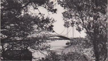 Phillip Island and District Historical Society Inc.
Photograph, Phillip Island Bridge
Glimpse of arched bridge between trees from left to right of photograph. Scrubby low bush in foreground. Tranquil water behind and under bridge to Newhaven sand beyond.Glimpse of bridge, San Remolocal history, photographs, bridges, san remo, black & white photograph, mona condrick -
 Orbost & District Historical Society
black and white photographs, 1937
These photographs are of the bridge across the Snowy River at Orbost which was replaced in 1976. This bridge over the Snowy River was opened on July 4 1922. It was constructed in 1922 alongside the previous suspension bridge. Its building was a combined effort of the Victorian Railways and the Country Roads Board at a cost of 35,000 pounds. It was replaced in 1976 by the present bridge after several major floods.This bridge was replaced in 1976 after several major floods. This is a pictorial record of that bridge.Three black / white photographs of a truss bridge across a river.bridge-snowy-river orbost-bridge-1937 -
 Wodonga & District Historical Society Inc
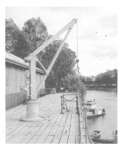
Photograph - The River Port of Red Bank
THE RIVER PORT OF REDBANK During the 1870s, Red Bank would have been one of the busiest ports on the Murray River. When the railway line was being built from Melbourne to Wodonga all the railway material was brought up river from Echuca by paddle steamer and barge and unloaded at Red Bank. The material was loaded onto horse teams or bullock wagons and taken along the route of the spur line. During the 187 MacCulloch & Co. handled 3000 tons of railway material here' The port was operational from approximately 1870 until 1874. THE FIG TREES The fig trees and a small bank of gravel are the only visible reminders of where the spur line from the wharf at Red Bank met the main line. It was at this point that all the material for the mainline was transferred from the small locomotives and wagons from Red Bank. It would have been carried by bullock wagons and horse teams and unloaded at different places as the line progressed. After the line was completed in 1873 the fettlers from Wodonga would patrol this length of the line.These images are significant because they document an important stage in the development of transportation in North East Victoria.Images of the River Port of Red bank near Wodonga on the Murray River. 1. The wharf 2. All that remainsred bank port, historic wharf wodonga, river transport -
 University of Melbourne, Burnley Campus Archives
Photograph - Black and white print, Children Playing in the River, Unknown
Black and white photograph. Children standing on rocks in the river (Yarra?) with a bridge above them. T H Kneen suggests it is the Melbourne Hawthorn Railway Bridge and that The Boulevard now passes under the arch.children, rocks, river, bridge, yarra, hawthorn railway -
 Phillip Island and District Historical Society Inc.
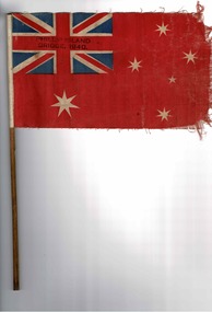
Flag, Flag for 1st bridge opening
Flag waved by school children at opening of Phillip Island Bridge HistoricalRed cloth flag with Union jack in left corner and southern cross. On thin wooden stickPhillip Island bridge 1940flag, opening of phillip island bridge 1940 -
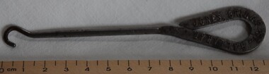 Buninyong Visitor Information Centre
Clothing - Button Hook, Button Hook from Jones, Bridge Street, Ballarat
Item sold by Jones, a shop located in Bridge Street, Ballarat.Metal button hook with hoop shaped handle, a narrow shaft ended with a small hook. The shop details are printed in relief on the handle.Jones, Bridge Street, Ballaratfootwear, clothing accessories, button hooks -
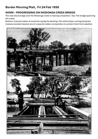 Wodonga & District Historical Society Inc
Photograph - Wodonga Creek Stock Bridge Collection
The Wodonga Creek Stock Bridge was constructed by the Country Roads Board in 1939. The date was recorded on a small plaque attached to one of the trestles. The bridge is an important reminder of one of the industries Wodonga was built on — cattle. It was constructed to develop a new stock route between Albury and Wodonga which would direct cattle away from the main bitumen roads and traffic bridges to the Wodonga Saleyards, where thousands of sheep and cattle were sold each month. It is a moderately tall timber trestle road bridge consisting of nine spans, with a deck length of 76 metres and deck width of 4.5 metres, and a maximum span length of 8.5 metres. The substantial timber deck featured decking laid horizontally and longitudinal running planks laid on top of it. The bridge also has timber side safety rails to discourage livestock from straying over the side. The bridge also became the centre of summer social activity for the young people of Wodonga as the area became a gazetted swimming area before the Wodonga Swimming Pool was constructed in 1959. In 1980 the Wodonga Saleyards were relocated to Bandiana to the east of the city. This meant that Wodonga Creek Stock Bridge was no longer needed for its original purpose. Although listed as a significant site by the Victorian Heritage and National Heritage Trust on 3/08/1998, the bridge fell into disrepair and also suffered damage from several floods. A suspension Bridge was constructed beside the Stock Route Bridge in 2013 and the old bridge was closed to traffic. Major damage caused by several floods, including a major flood in 2022 has resulted in the bridge being unsafe and its future is uncertain. The model of the Wodonga Creek Stock Bridge in our Collection made by Mr John Wild, depicts its current condition.The Wodonga Creek Stock Bridge is significant for technical, historic and social reasons and has been registered at the State Heritage level. It is of technical significance as a nine span bridge with tall timber trestles. Large bridges of this type are now very rare in Victoria. It is of historic significance as a surviving structurally authentic bridge designed specifically for livestock and drover use, on a historic stock route. The Stock Bridge is of social significance for its location at a popular riverside leisure spot since its construction in 1939.A collection of photographic images depicting the Wodonga Creek Stock Bridge. It contains both black and white and coloured images taken at different times in the Stock Bridge's history. A model of the Bridge made for Our Society is also included.wodonga creek stock bridge, wodonga heritage -
 Clunes Museum
Photograph, WHEELERS BRIDGE
SEPIA PHOTOGRAPH OF CONSTRUCTION OF "WHEELERS" BRIDGE AT LAWRENCE MOUNTED ON CARDBOARDTHE FIRST REINFORCED CONCRETE BRIDGE IN AUSTRALIA. ENGINEER - JOHN MONASH. LATER SIR JOHN MONASH.local history, photography, photographs, bridges -
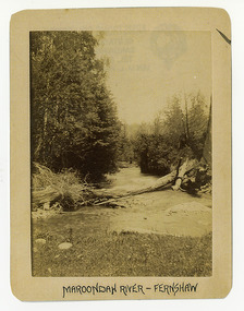 Marysville & District Historical Society
Photograph (Item) - Black and white photograph, Maroondah River - Fernshaw, c1900
An early black and white photograph of the Watts River at Fernshaw. The photograph has been incorrectly labeled as the Maroondah River - Fernshaw.An early black and white photograph of the Watts River at Fernshaw. The photograph has been incorrectly labeled as the Maroondah River - Fernshaw.ARMSTRONG COLLECTION 42 STATION STREET/ SANDRINGHAM 3191/ TEL. (03) 9521 5442/ IAN M.L. ARMSTRONG OAMwatts river, fernshaw, maroondah river, victoria -
![Waterfall Scene Near the Buchan River / [by] Nicholas Caire, circa 1876](/media/collectors/550653872162f11fb04854aa/items/57825da5d0cdd1176ce3ed3d/item-media/57825e03d0cdd1176ce418cf/item-fit-380x285.jpg) Kew Historical Society Inc
Kew Historical Society IncPhotograph, Anglo-Australasian Photographic Company, Waterfall Scene Near the Buchan River, c. 1876
Nicholas Caire was born on Guernsey in the Channel Islands in 1837. He arrived in Adelaide with his parents in about 1860. In 1867, following photographic journeys in Gippsland, he opened a studio in Adelaide. From 1870 to 1876 he lived and worked in Talbot in Central Victoria. In 1876 he purchased T. F. Chuck's studios in the Royal Arcade Melbourne. In 1885, following the introduction of dry plate photography, he began a series of landscape series, which were commercially successful. As a photographer, he travelled extensively through Victoria, photographing places few of his contemporaries had previously seen. He died in 1918. Reference: Jack Cato, 'Caire, Nicholas John (1837–1918)', Australian Dictionary of Biography.An original, rare photograph from the series 'Views of Victoria: General Series' by the photographer, Nicholas Caire (1837-1918). The series of 60 photographs that comprise the series was issued c. 1876 and reinforced a neo-Romantic view of the Australian landscape to which a growing nationalist movement would respond. Nicholas Caire was active as a photographer in Australia from 1858 until his death in 1918. His vision of the Australian bush and pioneer life had a counterpart in the works of Henry Lawson and other nationalist poets, authors and painters.‘Waterfall scene near the Buchan River’ : Views of Victoria (General Series), No.39 : Albumen silver photograph | Photo on card with Title and Description on reverse | Mounted 24 x 30 cm; Photo 12 x 17 cm.On Reverse: ‘The Buchan River is a tributary of the great Snowy River, which extends itself from Port Ricardo, on the Gipps Land coast, to considerably beyond Mt. Kosciusko, in New South Wales. It is comparatively but a stream, but, like most of the smaller rivers in Victoria, it contains some beautiful scenery, peculiar to itself. Our present illustration is characteristic of its scenery, and is taken from a creek close to the River.’nicholas caire (1837-1918), buchan river, landscape photography - victoria -
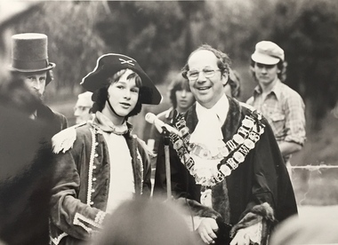 Kew Historical Society Inc
Photograph, Standard Newspapers, Charles Grimes Re-enactment, Yarra River, 1978
The party of the British surveyor Charles Grimes were the first Europeans to view the River Yarra, as it was later to be named. Members of the party reached the area now known as Studley Park in 1803. This local re-enactment commemorated 175 years since that event. Charles Grimes Re-Enactment, Yarra River, Kew, 1978. The photograph is of a student of Trinity Grammar School and the Mayor of Kew, Cr. Whiting. Inscription on reverse: "KH-161. Society's contribution to the 1978 Festival of Kew. Re-enactment of first white man's journey and discovery of the Yarra River and the area now know (sic) as Kew. 1978. This was in the year 1903 when Grimes and party came upon the Yarra to seek a possible site for a new convict settlement. Cr. Whiting, Mayor of Kew, receiving the report from Grimes, 'Andrew Allen'. Cr. Hutchinson in top hat 'town cryer'. Bush band in backround." Ripped stamp on reverse: "Standard N[ewspapers]."charles grimes re-enactment, trinity grammar school, cr whiting -- mayors -- kew (vic.), yarra river, andrew allen, kew historical society