Showing 513 items matching "yarra track"
-
 Ballarat Tramway Museum
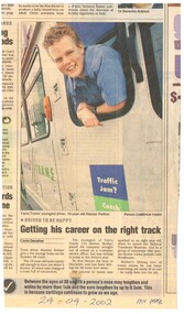
Newspaper, MX newspaper Melbourne, "Getting his career on the right track", 24/04/2002 12:00:00 AM
Newspaper clipping from the Melbourne MX newspaper, 24-4-2002 about BTM Museum member, Alastair Reither driving trams for Yarra on route 96, aged 19. Notes his involvement with the BTM. Item written by Caria Danaher and photo by Cameron Tandy.btm, yarra trams, drivers -
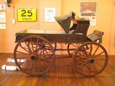 Australian Racing Museum
Ambulance, Jockey
Four wheeled single horse-drawn vehicle containing a wooden stretcher, shaded by a black canvas hood. Driver's seat of black leather. Vehicle used as a jockey's ambulance at Caulfield Racecourse during the 1890s.It had space for one stretcher. Horse drawn ambulances, despite having springs, could be very rough to travel in. They were gradually replaced by motor ambulances at Australian race tracks. This ambulance is currently on public display at the Ambulance Victoria Museum in Bayswater. -
 Kew Historical Society Inc
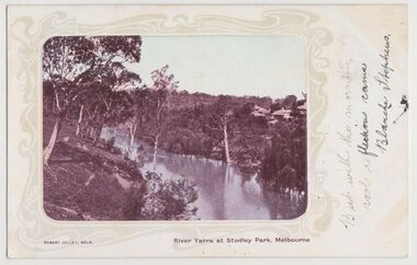
Postcard, River Yarra at Studley Park, Melbourne, 1900-04
Monochrome postcard titled lower right: “RIVER YARRA AT STUDLEY PARK, MELBOURNE”. The postcard was produced by ROBERT JOLLEY, MELB, (active 1900-1904). The photo is positioned to the left of the card and framed by an art nouveau design. A handwritten annotation on the front reads “BUT WITH THE MORNING / COOL REFLECTION CAME / BLANCHE STEPHENS”. On the reverse, there is a handwritten address in black ink to: MISS L STEPHENS / 26 WEST TERRACE / ADELAIDE. There is no division on the reverse of the postcard, dating it to before 1905. It lacks a postage stamp and postmark. Monochrome postcard of the River Yarra in Studley Park. The view is of the Yarra and its banks, with Kew on the left and Abbotsford on the right, as it appeared in the years 1900-1904. On the Abbotsford side of the river, there are a number of weeping willows lining the banks and houses on the hillside. The Studley Park side of the river includes some remnant vegetation and meandering walking tracks. Three very small figures are sitting on the Kew side. "RIVER YARRA AT STUDLEY PARK, MELBOURNE"river yarra -- kew (vic.), postcards -- kew, postcards -- studley park, robert jolley -
 Kew Historical Society Inc
Photograph - Grampians, 1924
Henry Beater Christian (1886-1962) , was a descendant of one of the earliest settler families in Kew. Employed at the Kew Asylum as a 'public servant', he was a skilled amateur photographer, photographing numerous scenes in Kew and on his travels around Victoria. The majority of his photographs date from 1916 to 1929. His finest photographs are housed in two photograph albums. Digital copy of a photograph from page 15 of the 47-page photograph album containing 261 gelatinous silver images, loaned by Diane Washfold with permission given to digitise and hold a copy in our collection. The first and last pages in the album document the Yarra River at Studley Park and at Kew. The remainder of the album includes photographs of walking and car tours in rural Victoria including 'wilderness' areas in the Grampians, Gippsland and the High Country. Six album pages document a camping trip by Henry Christian to the Grampians in September 1924. The photos include pictures of lookouts, and natural features including rock faces and waterfalls, as well as his camp site. This is a photo of a man in the distance on a bush track who is looking over his shoulder at the camera. He carries a sack and has a swag on his back. This may be Henry Christian or a companion."Grampians"henry beater christian (1886-1962), landscape photography, christian-washfold collection, photograph albums, grampians, gariwerd -
 Kew Historical Society Inc
Photograph - Grampians, 1924
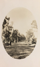
Henry Beater Christian (1886-1962) , was a descendant of one of the earliest settler families in Kew. Employed at the Kew Asylum as a 'public servant', he was a skilled amateur photographer, photographing numerous scenes in Kew and on his travels around Victoria. The majority of his photographs date from 1916 to 1929. His finest photographs are housed in two photograph albums. Digital copy of a photograph from page 15 of the 47-page photograph album containing 261 gelatinous silver images, loaned by Diane Washfold with permission given to digitise and hold a copy in our collection. The first and last pages in the album document the Yarra River at Studley Park and at Kew. The remainder of the album includes photographs of walking and car tours in rural Victoria including 'wilderness' areas in the Grampians, Gippsland and the High Country. Six album pages document a camping trip by Henry Christian to the Grampians in September 1924. The photos include pictures of lookouts, and natural features including rock faces and waterfalls, as well as his camp site. This is a photo of local flora on a bushland track in the Grampians, developed within an oval frame."Grampians"henry beater christian (1886-1962), landscape photography, christian-washfold collection, photograph albums, grampians, gariwerd -
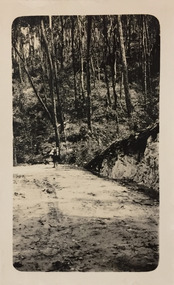
 Kew Historical Society Inc
Photograph - Strickland Spur track, c.1926
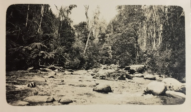
Henry Beater Christian (1886-1962) , was a descendant of one of the earliest settler families in Kew. Employed at the Kew Asylum as a 'public servant', he was a skilled amateur photographer, photographing numerous scenes in Kew and on his travels around Victoria. The majority of his photographs date from 1916 to 1929. His finest photographs are housed in two photograph albums. Digital copy of a photograph from page 18 of the 47-page photograph album containing 261 gelatinous silver images, loaned by Diane Washfold with permission given to digitise and hold a copy in our collection. This photograph, dating from c.1926, forms part of a group of photos of the Strickland Spur track, taken on a bushwalking trip to Marysville, Victoria. John Chapman has written in 'Bushwalking Clubs - A Brief History', about the establishment in Victoria of the first bushwalking club in 1888, and the popularisation of bushwalking during the interwar period. The photograph shows either the Steavenson or Taggerty River near Marysville. The photographer contrasts the rapid flow of the water through the rapids with the stillness of the surrounding tree ferns and trees."Spur" [illegible ink inscription]henry beater christian (1886-1962), landscape photography, kew (vic.) — yarra river, christian-washfold collection, photograph albums, bushwalking -- victoria, strickland spur -
 Kew Historical Society Inc
Photograph - Acheron Way, c.1926
Henry Beater Christian (1886-1962) , was a descendant of one of the earliest settler families in Kew. Employed at the Kew Asylum as a 'public servant', he was a skilled amateur photographer, photographing numerous scenes in Kew and on his travels around Victoria. The majority of his photographs date from 1916 to 1929. His finest photographs are housed in two photograph albums. Digital copy of a photograph from page 18 of the 47-page photograph album containing 261 gelatinous silver images, loaned by Diane Washfold with permission given to digitise and hold a copy in our collection. This photograph, dating from c.1926, forms part of a group of photos taken on a bushwalking trip to Marysville, Victoria. John Chapman has written in 'Bushwalking Clubs - A Brief History', about the establishment in Victoria of the first bushwalking club in 1888, and the popularisation of bushwalking during the interwar period. The photographer contrasts the rapid flow of the water of a river through the rapids with the stillness of the surrounding tree ferns and trees."Spur" [illegible ink inscription]henry beater christian (1886-1962), landscape photography, kew (vic.) — yarra river, christian-washfold collection, photograph albums, bushwalking -- victoria, strickland spur track -
![Scene near Corranderrk Station / [by] Nicholas Caire, circa 1876](/media/collectors/550653872162f11fb04854aa/items/57774ae0d0cdd10a5c12f2d7/item-media/57774b61d0cdd10a5c132dac/item-fit-380x285.jpg) Kew Historical Society Inc
Kew Historical Society IncPhotograph, Anglo-Australasian Photographic Company, Scene near Corranderrk Station, c. 1876
Nicholas Caire was born on Guernsey in the Channel Islands in 1837. He arrived in Adelaide with his parents in about 1860. In 1867, following photographic journeys in Gippsland, he opened a studio in Adelaide. From 1870 to 1876 he lived and worked in Talbot in Central Victoria. In 1876 he purchased T. F. Chuck's studios in the Royal Arcade Melbourne. In 1885, following the introduction of dry plate photography, he began a series of landscape series, which were commercially successful. As a photographer, he travelled extensively through Victoria, photographing places few of his contemporaries had previously seen. He died in 1918. Reference: Jack Cato, 'Caire, Nicholas John (1837–1918)', Australian Dictionary of Biography. The 1860s marked the beginning of the era of reserves and missions. Six Aboriginal reserves were established during the 1860s. These were under the control of the Board for the Protection of Aborigines. Four were Christian missions receiving government aid. These were Lake Tyers (Anglican) and Ramahyuck (Presbyterian/Moravian) in eastern Victoria for the Gunai/Kurnai clans; Ebenezer (Moravian) in north-west Victoria for the clans of the Wimmera and Lower Murray; and Lake Condah (Anglican) in south-west Victoria. The other two were secular government controlled reserves: Framlingham which, like Lake Condah, was established for the Mara-speaking Gunditjmara and Kirrae-wurrung people of south-west Victoria; and Coranderrk, located about 60 kilometres north-east of Melbourne, for the Kulin clans of central Victoria. In 1863, after a period of devastation to the Kulin people, Coranderrk was established at the junction of the Yarra River and Badger Creek. Reference: http://coranderrk.com/, accessed 24 December 2016An original, rare photograph from the series 'Views of Victoria: General Series' by the photographer, Nicholas Caire (1837-1918). The series of 60 photographs that comprise the series was issued c. 1876 and reinforced a neo-Romantic view of the Australian landscape to which a growing nationalist movement would respond. Nicholas Caire was active as a photographer in Australia from 1858 until his death in 1918. His vision of the Australian bush and pioneer life had a counterpart in the works of Henry Lawson and other nationalist poets, authors and painters.Albumen silver photograph mounted on boardprinted in ink on support l.c.: SCENE NEAR "CORRANDERRK" STATION. / COPYRIGHT REGISTERED. printed in ink on support reverse c.: VIEWS OF VICTORIA. / (GENERAL SERIES.) / No. 9. / SCENE NEAR "CORRANDERRK" STATION. / This scene was taken from the hill near Rourke's Bridge, on the Healesville Road, and displays in the foreground / the River Yarra. The roadway which is seen in the mid-distance has lately been constructed by the Government, / as the old tracks which formerly existed, were liable to be swamped by the periodical overflowing of the River. Mount / Ridell can be seen in the extreme distance immediately behind the roadway. / Corranderrk is the local habitation / for the natives of this district, and is situated on the right hand side of the picture, about a mile and a half / from the roadway. printed in ink on support reverse l.c.l.: J.W. FORBES, Agent, printed in ink on support reverse l.c.: ANGLO-AUSTRALASIAN PHOTOGRAPHIC COMPANY, MELBOURNE. printed in ink on support reverse l.c.r.: 10 Temple Court, Collins Street West.nicholas caire (1837-1918), coranderrk aboriginal station, aborigine, yarra river, badger creek, first peoples, aboriginal and torres straight islander -
 Kew Historical Society Inc
Photograph, Kilby Farm, Kew East
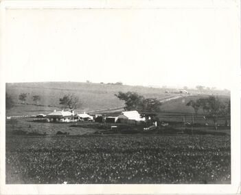
Kilby Lodge (c.1845-c.1922). William Oswin purchased Crown Land Lots 52 & 53 in 1845. These lots ran north from an old bullock track [later Kilby Road] to the Yarra, and east to Burke Road. Oswin purchased a neighbouring Lot in 1851, separated by the bullock track from the rest of the farm. Oswin built ‘Kilby Lodge’ and, with his brother, farmed dairy cattle on the site. Oswin’s descendants owned the farm into the 1890s. New subdivisions of Kilby and neighbouring farms in the 1920s changed the rural nature of north Kew. Housing and large recreation reserves replaced dairy farms and market gardens. This work forms part of the collection assembled by the historian Dorothy Rogers, that was donated to the Kew Historical Society by her son John Rogers in 2015. The manuscripts, photographs, maps, and documents were sourced by her from both family and local collections or produced as references for her print publications. Many were directly used by Rogers in writing ‘Lovely Old Homes of Kew’ (1961) and 'A History of Kew' (1973), or the numerous articles on local history that she produced for suburban newspapers. Most of the photographs in the collection include detailed annotations in her hand. The Rogers Collection provides a comprehensive insight into the working habits of a historian in the 1960s and 1970s. Together it forms the largest privately-donated collection within the archives of the Kew Historical Society.A panoramic photograph of Kilby (or Oswin's) Farm in East Kew."Kilby Farm when Oswins owned it. Commenced 1845."kilby farm, kilby lodge, william oswin, dorothy rogers, kew east -
 Round the Bend Conservation Co-operative
One of the many work parties paving the tracks of the Co-op
-
 Lilydale RSL Sub Branch
Print, KOKODA
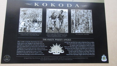
Framed Print with heading KOKODA and words Courage, Endurance, Mateship, Sacrifice underneath. Three photographs relating to the Kokoda Track and four paragraphs with headings "The Kokoda Legend", "The Kokoda Campaign", "The Fuzzy Wuzzy Angels" and "The Battle of Isurava".Limited edition 1614 0f 5000 -
 Mrs Aeneas Gunn Memorial Library
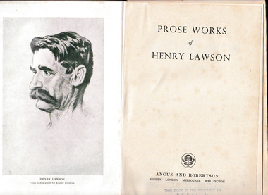
Book, Angus and Robertson, Prose works of Henry Lawson, 1957
Two volumes of short stories by Henry Lawson (1867-1922) . Volume one organised into four sections: 'While the Billy Boils' (first series); 'While the Billy Boils' (second series); 'On the track'; 'Over the sliprails'. Volume two organised into five sections: 'Joe Wilson'; 'Joe Wilson's Mates'; 'The romance of the swag'; 'The rising of the court'; 'Send round the hat'.Index, p.684.Two volumes of short stories by Henry Lawson (1867-1922) . Volume one organised into four sections: 'While the Billy Boils' (first series); 'While the Billy Boils' (second series); 'On the track'; 'Over the sliprails'. Volume two organised into five sections: 'Joe Wilson'; 'Joe Wilson's Mates'; 'The romance of the swag'; 'The rising of the court'; 'Send round the hat'. australia - social life and customs, australia - literary works -
 Mrs Aeneas Gunn Memorial Library
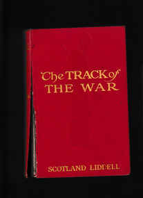
Book, Simpkin, Marshall, Hamilton, Kent & co., limited, The track of the war, 1915
An account of the invasion of Belgium by Germany in World War OneIll, p.276.non-fictionAn account of the invasion of Belgium by Germany in World War Oneworld war 1914-1918 - campaigns - belgium, world war 1914-1918 - personal recollections -
 Mrs Aeneas Gunn Memorial Library
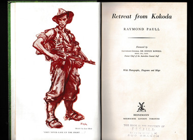
Book, Heinemann, Retreat from Kokoda, 1958
An account of the Kokoda campaignIndex, ill, maps, p.319.non-fictionAn account of the Kokoda campaignworld war 1939-1945 - campaigns - new guinea, kokoda track -
 Mrs Aeneas Gunn Memorial Library
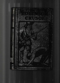
Book, Sands and Co, The life and adventures of Robinson Crusoe, 1902
The timeless tale of survival and adventure that set the standard for the English novelRobinson Crusoe is the only man still alive when his ship is destroyed in a terrible storm. Washing up on a deserted island, he realizes that he is stranded, with no immediate hope of rescue. Displaying remarkable ingenuity, Crusoe builds a crude home, raises crops, and keeps track of the passing days with a rudimentary calendar. Loneliness is his greatest adversary until a tribe of cannibals arrives with their intended victims. When one of the prisoners escapes, Crusoe rescues him.Ill, p.378.fictionThe timeless tale of survival and adventure that set the standard for the English novelRobinson Crusoe is the only man still alive when his ship is destroyed in a terrible storm. Washing up on a deserted island, he realizes that he is stranded, with no immediate hope of rescue. Displaying remarkable ingenuity, Crusoe builds a crude home, raises crops, and keeps track of the passing days with a rudimentary calendar. Loneliness is his greatest adversary until a tribe of cannibals arrives with their intended victims. When one of the prisoners escapes, Crusoe rescues him. juvenile fiction, adventure fiction -
 Mont De Lancey
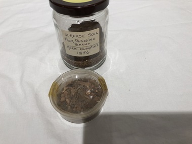
Soil
Soil from Olympic Games in Melbourne at MCG in 1956Surface soil from Olympic Running Track at Melbourne Cricket Ground (1956) in the containersoil specimens -
 Mont De Lancey
Tool - Fettler's pick, circa 1900
Used circa 1900.A steel Fettler's pick head. One end is flattened and squared off and it has a long point at the opposite end. It was used to maintain railway tracks in the 19th century.It is stamped - 1 with an arrow pointing downwards.tools, hand tools, picks -
 Melbourne Tram Museum
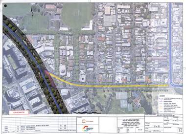
Drawing - Set of 5, Melbourne Metrorail, "Melbourne Metro St Kilda Road - early works", 10/2016
Drawings prepared by the Melbourne Metro project to show the relocation of Domain Interchange, Domain Road and Park St South Yarra to Toorak Road West and St Kilda Road. Drawings prepared for a Heritage Victoria application dated 26/10/2016. Shows the various work stages principally at the site of Domain Junction where the tram tracks had to be relocated to facilitate the construction of Anzac station.Yields information about the relocation of Domain Interchange to facilitate the construction of the Melbourne Metro.Set of five laminated A3 colour prints with a punch hole in the top left hand corner.metro tunnel, domain interchange, domain road, toorak road, st kilda road, heritage victoria, anzac station -
 Melbourne Tram Museum
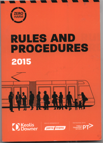
Document, Yarra Trams, "Rules and Procedures", June 2015
"Rules and Procedures" - dated June 2015 with a forward by Clement Michel, CEO Yarra Trams. Details the rules and procedures for drivers, including the Cardinal Rules, and for Customers, services, incident management, general rules, track and stud marks and definitions. Issued to crews. Has the logos of Keolis Downer, Yarra Trams and Public Transport Victoria on the front cover.Yields information about the rules and procedures for Melbourne tram drivers.Document or book - 104 pages colour perfect binding.tramways, tramcars, rules, drivers, procedures, yarra trams -
 Eltham District Historical Society Inc
Book, Jenny Brown et al, Out of the Mist; Osborne Peninsula, 2024
... The Osborne Peninsula on the Yarra River at Warrandyte ...The Osborne Peninsula on the Yarra River at Warrandyte accommodates a limited number of properties and residents (70 households). The area is rich in geology and ecology, and an unusually rich endowment of human, built and creative history. Contents: Welcome: The landform: The River: Aboriginal occupation: The Miners: North Warrandyte :The Subdivision: The Lowes: The Osbornes: The Last Osborne: The Elders: The Relics: Dray Track: Water Wheel"Kauri Plaque: River track: Pines: Windmill Creek Bridge: The Koornong School: The Houses" Man Cave: MidCentury Classic: Enduring Original" Masterwork: The Muddies: The State Park: The Saving of Koornong Reserve: The Landcare Story: Flora and Fauna: The Vulnerable, Endangered and threatened: Birds: Mammals: "Waring" the wombat: Reptiles: Fish: Invertebrates: Flora: Fire. Published by the North Warrandyte (Osborne Peninsula) Landcare Group. Includes photos from EDHS collection.64 p. : ill., map ; 29.7 x 21 cm. (2 copies)yarra river, birrarung, dray track, fauna, geology, houses, indigenous history, koornong reserve, koornong school, lowe family, mining, mudbrick houses, north warrandyte, osborne family, warrandyte state park, water wheel, north warrandyte (osborne peninsula) landcare group, osborne peninsula -
 Eltham District Historical Society Inc
Photograph - Digital Photograph, Alan King, Kinglake National Park, 27 March 2008
Fern gullies around Jehosaphat Gully Covered under National Estate. Published: Nillumbik Now and Then / Marguerite Marshall 2008; photographs Alan King with Marguerite Marshall.; p125 The magnificent Kinglake National Park, fringing Nillumbik’s north, is the largest national park close to Melbourne. Thanks to the vision and hard work of a band of local people, the park was created from what was rapidly becoming degraded land. Seeing a threat to Kinglake’s indigenous flora and fauna, several prominent local people campaigned for a national park, which was established in 1928.1 Since then, the park has grown through donations and acquisitions of land, from around 13,800 acres of land (5585ha) to 22,360 hectares. The Sugarloaf and Everard Blocks – of almost 8000 hectares – stand in Nillumbik and the park extends into Mitchell and Murrundindi Shires and the City of Whittlesea. Mt Everard commemorates William Hugh Everard, State member for Evelyn when the park was established. Before 1928, European settlers had degraded the Kinglake area, which was named after the celebrated English author and lawyer, Alexander William Kinglake. Remains of gold shafts and diggings in the park are reminders of Kinglake’s first settlers, who hoped to strike it rich at the gold diggings. But like other gold fields in this shire, they proved not very lucrative and soon timber cutting replaced mining in importance. However, before long, the accessible timber supply ran out, so in the 1920s agriculture took over – particularly potatoes and berry fruits – which involved large-scale clearing.2 The park’s instigator was retired Melbourne University Professor of Music, William Laver.3 As chair of the Kinglake Progress Association he began negotiations to have crown lands on the southern scarp of the Great Dividing Range reserved as a national park. Even before the park was proclaimed, from 1927, KPA members cut tracks to the major scenic points. Professor Laver was one of several people who gave land for the park, donating around 50 acres (20ha), including the Jehosaphat Gully.4 Laver chaired the park’s first Committee of Management, which raised money to employ a ranger and provide facilities, including tracks and roads for fire protection vehicles, toilets and shelters. The committee charged fees for firewood collection, some grazing of livestock, and visitor entrance, and obtained small State Government and Eltham Shire grants. In 1957 the State Government provided revenue for national parks. Then, in 1975, the State Government took over the management and the Committee of Management became an advisory committee, which disbanded in 1978. Originally, the park covered crown land in the Shires of Eltham and Whittlesea; then Wombelano Falls in Yea and other areas were added. In 1970 the park extended into the Shires of Eltham, Healesville, Whittlesea and Yea.5 Bush fires have been an ongoing problem. In 1939 hundreds of eucalypts and acacias had to be sown around the Jehosaphat Gully to rejuvenate the forest. To manage bushfires, the Committee of Management, then the State Government, worked closely with the Forestry Commission, shire councils and local fire brigades. Early national parks focussed on recreation. But by the 1980s, conservation, education and scientific research became more important, playing a vital role in preserving representative samples of the natural environment. Each year many thousands of people use the park’s extensive network of walking tracks amongst the protected plant and animal life as well as camping, cycling and horse riding. The park, along the slopes of the Great Dividing Range, has lookouts revealing magnificent views of the Melbourne skyline, Port Phillip Bay, the Yarra Valley and the You Yangs. Vegetation in the Masons Falls area includes messmate forest, Austral grass-trees, ferns and Hazel Pomaderris. In spring, orchids, lilies, everlasting daisies, correas, grevillea and heath appear. Around Jehosaphat Gully are wet and dry forest, fern gullies and banksia. Animal life includes wallabies, kangaroos, koalas, echidnas, possums, gliders and bandicoots. Male lyrebirds can be heard mimicking in the Jehosaphat Gully, particularly in the Everard Block in winter.This collection of almost 130 photos about places and people within the Shire of Nillumbik, an urban and rural municipality in Melbourne's north, contributes to an understanding of the history of the Shire. Published in 2008 immediately prior to the Black Saturday bushfires of February 7, 2009, it documents sites that were impacted, and in some cases destroyed by the fires. It includes photographs taken especially for the publication, creating a unique time capsule representing the Shire in the early 21st century. It remains the most recent comprehenesive publication devoted to the Shire's history connecting local residents to the past. nillumbik now and then (marshall-king) collection, kinglake national park, jehosaphat gully -
 Melbourne Tram Museum
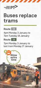
Pamphlet, Yarra Trams, Buses Replace Trams - Routes 58, 59, 86 and 96, 2022
.1 - pamphlet provided at tram stops giving details of the works and bus services for routes 58 and 59 .2 - Project document describing the work and dates - downloaded from the Yarra Trams website after buses were used to replace route 58 from the Royal Children's Hospital rather than from Royal Park Station as originally planned. .3 - as for .1 - for the upgrading of the Merri Creek Bridge - route 86 - see also Reg Item 6066 .4 - as for .1 - for the installation of superstops in Nicholson St between Elgin St and Holden St - route 96Shows the methods that Yarra Trams customers are advised of changes due to track replacement works..1 - Pamphlet - DL, four fold printed on off white paper titled - Buses Replace Trams - Route 58 and Route 59 - Jan 2022 .2 - Project sheet - 3 A4 sheets, titled "Renewal works: Essendon Depot and Mt Alexander Road - 3.1 to 18.1.2022. .3 - Pamphlet - DL 3 fold, Buses Replace Trams, route 86, November 2021 - Merrit Creek Bridge works .4 - Pamphlet - DL - 4 fold, Buses Replace Trams, route 96, January 2020 - Nicholson St works for tram super stops.mt alexander road, tram works, track work, route 58, route 59, yarra trams, ptv, essendon tram depot, route 86, route 96, nicholson st, merri creek, bridges, carlton, super stops, trams, tramways, northcote -
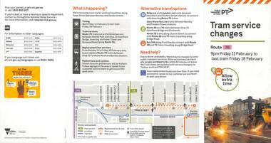
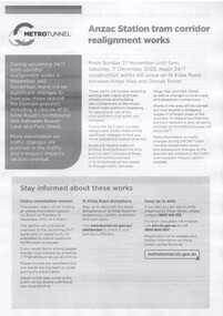
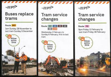 Melbourne Tram Museum
Pamphlet, Yarra Trams, Tram Service Changes, 2022
... replacement bus services on route 58 .3 - as for .1 - track ....1 - pamphlet provided at tram stops giving details of the works and bus services for 86 - Merri Creek Bridge works .2 - ditto - for provision of a super stop in William St at Collins St including replacement bus services on route 58 .3 - as for .1 - track reconstruction in Swan St between Stanley St and Stawell St Richmond or BurnleyShows the methods that Yarra Trams customers are advised of changes due to track replacement works..1 - Pamphlet - DL, three fold DL - Buses replace trams - route 86 - 28/11/2021 to 5 December 2021 - Route 86 .2 - Pamphlet - DL, four fold DL - Tram Service changes 2/2/2022 to 6/2/2022 - Routes 11, 12, 35, 48, 58 and 109 .3 - Pamphlet - DL, four fold DL - Tram Service changes - 11/2022 to 18/2/2022 - Route 70tram works, track work, route 58, yarra trams, ptv, route 86, merri creek, bridges, super stops, trams, tramways, richmond, burnley, route 70, collins st, william st -
 Melbourne Tram Museum
Pamphlet, Public Transport Victoria (PTV), Tram Service Changes, 2022
... services for: .1 - route 72 track reconstruction between Chapel St ...Pamphlet provided at tram stops giving details of the works and bus services for: .1 - route 72 track reconstruction between Chapel St and Orrong Road, in Malvern Road including the Orrong Road over rail line bridge - 29-4-2022 to 14-5-2022 .2 - All Collins and William St routes for the installation of a super stop in William St at Collins St - - 2-2-2022 to 6-2-2022Shows the methods that Yarra Trams and Public Transport Victoria customers are advised of changes due to track replacement works..1 - Pamphlet - DL, five fold DL - Tram service changes - route 72 - 29-4-2022 to 14-5-2022 .2 - Pamphlet - DL, four fold DL - changes in Collins and William Streets - 2-2-2022 to 6-2-2022tram works, track work, yarra trams, ptv, bridges, trams, tramways, route 72, malvern road, orrong road, super stops, collins st, william st -
 Melbourne Tram Museum
Pamphlet - Tram works on Swan St, Yarra Trams, Tram Service Changes, 2022
... Road Bridge, Richmond .3 - as for .1 - track reconstruction ....1 - pamphlet provided at tram stops giving details of the works for 70 .2 - ditto - for Tram Network Upgrade - Swan St and Wallen Road Bridge, Richmond .3 - as for .1 - track reconstruction in Swan St between Stanley St and Stawell St Richmond or BurnleyShows the methods that Yarra Trams customers are advised of changes due to track replacement works. .1>.2 - Pamphlet - DL, four fold DL - Tram Service changes - 11/2022 to 18/2/2022 - Route 70 .3>.4 - Pamphlet - DL, four fold DL - Tram Network Upgrade - Swan St and Wallen Road Bridge, Richmond .5 - Newspaper clipping - Tram works on Swan Sttram works, track work, yarra trams, ptv, bridges, trams, tramways, richmond, burnley, route 70, wallen road bridge -
 Melbourne Tram Museum
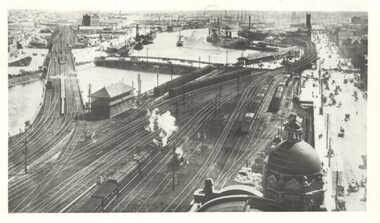
Photograph - Yarra River from Flinders St Station clock tower, Town and Country Journal, 1909
Photos show the Yarra river and the shipping turning basin that was used prior to the construction of the Spencer St bridge. In the view are are steam hauled suburban trains, Flinders St A signal box, Queensbridge, and the wharves on either side of the river. The viaduct was expanded to four tracks in 1915. Yields information about Yarra River, Flinders St railway station yards and shipping,Set of two photographs looking west from the Flinders St Station clocktower. over the Yarra River and station yards.On rear of both prints in ink: 1 – Melbourne - West from clock tower on Flinders St station - “Town and Country Journal 21/7/1909” Copy neg Mark Plummer collections ex late John Alfred collection. .2 - Melbourne, Looking west along Flinders St from clocktower of Flinders St station. Copy neg Mark Plummer collections ex late John Alfred collection. Has “T&C 20/12/09” in pencil on rear. bridges, flinders st station, yarra river, wharves, railways, signal boxes, queens bridge, shipping -
 Melbourne Tram Museum
Pamphlet - Metro Tunnel - Anzac Station tram corridor works, Rail Projects Victoria, 11/2022
Provides information about the works planned to realign tram tracks at the Metro Tunnel Anzac station, following the completion of the surface works. Gives timing, tram routes affected, plans of the proposals, contact details. All St Kilda Road routes would be affected from 27/11/2022 to 17/12/2022, tram stops would be closed, bus replacement services. includes works to remove the Glenhuntly Road level crossing at Glenhuntly Station. Yields information about the trackworks for the future Anzac Station interchange and St Kilda Road services.Set of two documents issued by Rail Projects Victoria (Metro Tunnel) and Yarra Trams with regard to the reallignment of tram tracks at Anzac Station Nov. 2022 1 - Metro Tunnel - Works proposed, maps - 6 A4 pages 2 - Yarra Trams - Service Changes St Kilda Road works - 4 A4 pages.anzac station, metro tunnel, tramways, st kilda road, domain road, domain interchange, park street, track work, tram tracks, glenhuntly road, glenhuntly station, level crossings -
 Melbourne Tram Museum
Poster, Tram Service Changes, March 2022
Poster advising passengers in trams of the planned service changes for April, June and July 2022. Includes the Grand Prix, public holidays, Malvern Road, Glenferrie Road track renewals and Glenhuntly level crossing removal.Demonstrates the methods that Yarra Trams use to advise passengers of service changes.A3 size colour poster regarding tram service changes. Two plastic covers that contain the posters in the rack included in the A3 folder.posters, tramways, trackwork, passengers, tramcars, glenhuntly station, grand prix -
 Melbourne Tram Museum
Poster, PTV & Yarra Trams passenger safety - Tram Coach
Set of four full colour posters advising passengers on how to travel safely. Part of the Tram Coach series 1 - using strap hangers or handles - 2017 2 - holding onto poles etc - also tram cleaning and washing hands - Covid19 - 2020 3 - tram travel for visitors to Melbourne - from a far away place? - 2019 4 - offering priority seats to passengers - 2018 - 2 copies 5 - day dreaming = stop before you cross tram tracks - has an E class in Nicholson St City area - not dated.Demonstrates the methods that Yarra Trams & PTV use to advise passengers how to travel safely.Set of four A3 size colour posters passenger safety postersposters, tramways, passengers, tramcars, safety, covid-19 -
 Vision Australia
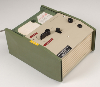
Equipment - Object, Specto Ltd, Clarke and Smith talking book machine with tapete
In 1965 the Clarke & Smith Talking Book Cassette Cartridge made it's debut at the Olympia Show. Popularly known as a 'tapete', it weighed considerably less than the earlier book cassette cartridges and allowed for up to 6 tracks (13 hours recording time) to be played.Clarke and Smith talking book cassette cartridge player consisting of plastic rectangular case with buttons for navigational controls, light green front and top of machine and darker green on sides, power cord and 5 buttons. Also includes tapete "Words for murder perhaps" by Edward Candy and ready by Stanley Pritchard.Clarke & Smith Track change Play -- Off Volume Phones This equipment remains the property of the Braille & Talking Book Library, 31-51 Commercial Road, South Yarra, 3141. Phone: (03) 267 6022 Dyna Tape labels: J21075 Play Rewindaudio equipment, clarke and smith