Showing 4783 items matching " authority"
-
 Uniting Church Archives - Synod of Victoria
Photograph, undated
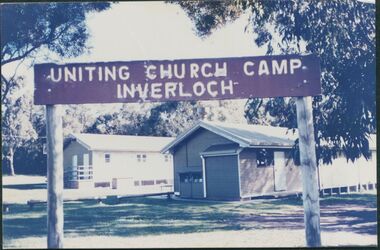
The photograph is from the Brian Walsh Collection 1993. Three blocks of land were purchased in 1946 by Miss F. Ritchie and Mrs H. Grimshaw in Halford St. Inverloch. Three more blocks were purchased in 1948 - 1949. A sixth block was added in 1956. Money was raised by P.F.A. members. Two buildings were purchased from the Government Disposals Authority in 1959. Construction of the camp began in October 1959. Regular working bees were held by P.F.A. members. The first camp was held at the site at Easter 1960. The camp was opened by the Moderator the Rt. Rev. A. Creighton Barr and Flinders Presbytery ministers. In 1998 the decision was taken to sell the site. No buyer was recorded by April 2000.Colour photograph mounted on card showing the exteriors of two camp dormitories in bushland.Uniting Church Camp Inverloch. Gippsland Presbytery. Brian Walsh Collection 1993presbyterian church camp, inverloch, flinders presbytery, p.f.a., miss f. ritchie, mrs. h. grimshaw, rt. rev. creighton barr -
 City of Greater Bendigo - Civic Collection
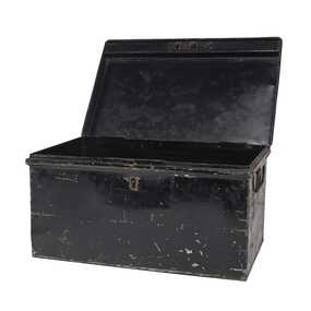
Functional object - Metal Box, Unknown
The first local government authority for Marong was the Marong Road District (an early form of single-purpose local government), which was proclaimed on 19 August 1860. Its boundary was altered twice in 1862 and on 12 December 1864 it was re designated as a Shire. It absorbed Raywood Borough in 1915, and was proclaimed a Rural City in 1990. On 2 December 1994, with the creation of Greater Bendigo City Council, it was abolished by being amalgamated with Bendigo City, Eaglehawk Borough, Huntly Shire, part of McIvor Shire, part of Metcalfe Shire and Strathfieldsaye Shire to form the City of Greater Bendigo. This metal box contained a roll of admission tickets and was possibly used for holding cash at the swimming pool or other municipal facility. Lockable painted metal box. Shire of Marongshire of marong -
 City of Greater Bendigo - Civic Collection
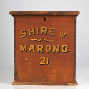
Functional object - Ballot Box, Shire of Marong, Shire of Marong 21, Unknown
The first local government authority for Marong was the Marong Road District (an early form of single-purpose local government), which was proclaimed on 19 August 1860. Its boundary was altered twice in 1862 and on 12 December 1864 it was re designated as a Shire. It absorbed Raywood Borough in 1915, and was proclaimed a Rural City in 1990. On 2 December 1994, with the creation of Greater Bendigo City Council, it was abolished through the amalgamation which took place between Bendigo City, Eaglehawk Borough, Huntly Shire, part of McIvor Shire, part of Metcalfe Shire and Strathfieldsaye Shire to form the City of Greater Bendigo. This box would have been used to collect votes during council elections.Wooden, painted, lidded box with hinged opening lid. Central slit in lid to insert ballot papers. Front face painted in black and gold paint. Hinged at back of box with lock on front. Front of box Shire of / Marong / 21shire of marong -
 City of Greater Bendigo - Civic Collection
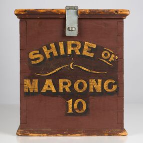
Functional object - Ballot Box, Shire of Marong, Shire of Marong 10, Unknown
The first local government authority for Marong was the Marong Road District (an early form of single-purpose local government), which was proclaimed on 19 August 1860. Its boundary was altered twice in 1862 and on 12 December 1864 it was re designated as a Shire. It absorbed Raywood Borough in 1915, and was proclaimed a Rural City in 1990. On 2 December 1994, with the creation of Greater Bendigo City Council, it was abolished through the amalgamation which took place between Bendigo City, Eaglehawk Borough, Huntly Shire, part of McIvor Shire, part of Metcalfe Shire and Strathfieldsaye Shire to form the City of Greater Bendigo. This box would have been used to collect votes during council elections.Wooden painted, lidded box with hinged opening lid. Central slit in lid to insert ballot papers. Front face painted in black and gold paint. Hinged at front of box with lock on back. Handle attached to the back.Front of box; Shire of / Marong / 21shire of marong -
 Melbourne Legacy
Photograph, Legacy 50th Anniversary, 1973
Photos of the 50th Anniversary Dinner on 6 October 1973 held at Chaucers. It shows a table with Ivan Layton and Matron Vivian Bullwinkel. Ivan was the CEO of Legacy for 30 years. Matron Bullwinkel was a good friend of his. The wellness centre at Legacy House was named after Vivian Bullwinkel in 2020. An electronic copy of the article that appeared in Mufti 2022 is included here which features her life and service. Photos came from an envelope marked P1 Federal Conference 1973 / 50 Year anniversary / 1983 Morewell / 1973 Legacy March ANZAC Day, 50 yr celebration, inclusion in ANZAC Day March authority of RSL". See items 00451,00452,00453, 00391. A record of a dinner marking the 50th anniversary of Legacy during the Golden Jubilee year 1973.Black and white photo of a dinner for the 50th anniversary of Legacy in 1973.Both stamped "This Photograph is the compliments of the Ministry of Tourism, Government of Victoria. Please acknowledge Michael Cheshire" in grey ink. Label on front says "Ivan Layton and Matron Vivian Bullwinkel"golden jubilee, 50th anniversary, ivan layton, vivian bullwinkel -
 Melbourne Legacy
Photograph, Legacy 50th Anniversary Conference, 1973
Photos of the 50th Anniversary Conference in 1973 which was held in Dallas Brooks Hall. Photos include some of the delegates, 01418.3 is President Handbury, Glen Correr and Jim Stewart, all from Melbourne. 01418.4 show Tom Yost and Goodie Ewence from Launceston and another man. 01418.5 from left, unknown, Graham Rhodes (Melbourne), Andrew Ireland (Wagga Wagga) and unknown. Photos came from an envelope marked 'P1 Federal Conference 1973 / 50 Year anniversary / 1983 Morwell / 1973 Legacy March ANZAC Day, 50 yr celebration, inclusion in ANZAC Day March authority of RSL'. See items 00451 to 00455, 00460 to 00464, 00391 and 01419. A record of a Legacy Conference in Melbourne during the Golden Jubilee year 1973.Black and white photo x 5 of the 50th Anniversary Legacy conference in 1973.All stamped "This Photograph is with the compliments of the Ministry of Tourism, Government of Victoria. Please acknowledge Michael Cheshire" in grey ink.golden jubilee, conference -
 Melbourne Legacy
Photograph, Legacy 50th Anniversary, 1973
Photos of an event for Legacy at Queen's Hall in the Victorian Parliament House. Exact event and date unknown but stored with items of the 50th Anniversary celebrations in 1973. The photos show President Geoff Handbury making a speech and his wife Helen (in black gloves), Dame Mary Herring and Sir Edmund Herring to the right hand side of the photo. Also views from a balcony down on the attendees. Photo came from an envelope marked P1 Federal Conference 1973 / 50 Year anniversary / 1983 Morewell / 1973 Legacy March ANZAC Day, 50 yr celebration, inclusion in ANZAC Day March authority of RSL". See items 00451 to 00455, 00460 to 00464, 00391, 01418, 01419. A record of an event at Parliament house to mark the 50th anniversary of Legacy during the Golden Jubilee year 1973.Black and white photo x 4 an event held at Parliament house for Legacy in 1973.All stamped "This Photograph is with the compliments of the Ministry of Tourism, Government of Victoria. Please acknowledge Michael Cheshire" in grey ink.golden jubilee, legatee event -
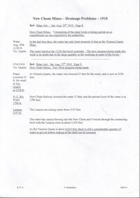
 Melbourne Tram Museum
Document - Press Release, The Met, "100 years of trams", 1985
Prepared by the Metroplitan Transit Authority for the celebration of 100 years of trams in Melbourne - 1985 1 - "Melbourne celebrates 100 years of trams" - 2 sheets - introduction to the event celebrations. 2 - "Tramway Centenary Celebrations" - 3 sheets - schedule of events 3 - "The cable tram" - 9 sheets - including many copies of old press clippings. 4 - "Cavalcade on Sunday 10 November" - 3 sheets - provides a list of trams to be used. 5 - "One Hundred years of Melbourne's trams: A short History" - 4 sheets 6 - "The Opening of the first tramway" - 3 sheets - Spencer St to Richmond The folder also contains the book "100 years of Melbourne Trams" - item 97. Provides infomation about the event to celebrate 100 yeas of trams in Melbourne in 1985Light card folded folders containing 6 press Media Information A4 sets of sheets stapled in top left hand corner, printed with the "100 years of trams" logo.melbourne, tramways, trams, 100 years of trams, the met, cable trams, mta, horse trams, events -
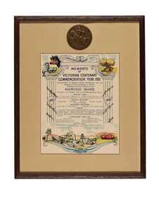 City of Greater Bendigo - Civic Collection
Artwork, other - Commemorative print and medal, Bolton Brothers Printers, 1951
The first local government authority for Marong was the Marong Road District (an early form of single-purpose local government), which was proclaimed on 19 August 1860. Its boundary was altered twice in 1862 and on 12 December 1864 it was re designated as a Shire. It absorbed Raywood Borough in 1915, and was proclaimed a Rural City in 1990. On 2 December 1994, with the creation of Greater Bendigo City Council, it was abolished through the amalgamation which took place between Bendigo City, Eaglehawk Borough, Huntly Shire, part of McIvor Shire, part of Metcalfe Shire and Strathfieldsaye Shire to form the City of Greater Bendigo. This memento commemorates the centenary of gold discovery in Victoria and was presented to school children in the Marong Shire.Framed and mounted commemorative certificate with Victorian Centenary Medal top centre.Memento / of / Victorian Centenary / Commemoration Year 1951 / Shire of Marong -
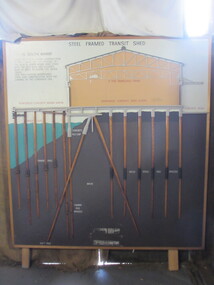 Seaworks Maritime Museum
Diagram
Cross section of wharves and steel framed sheds built along the Yarra river between the 1920s and 1960s. The South Melbourne side of the Yarra River is reclaimed swamp land. Without a solid foundation for the construction of the wharves and transit sheds, extended piles were sunk into the mud to support the wharf and shed structures. An example of this design may be found at 5 South Wharf which was built in the 1930s. The transit sheds gave shelter for cargo while waiting to be loaded onto a ship or to be collected by truck after being unloaded from a ship. The transit shed became surplus to requirements with the introduction of containers.Wooden diagram of a transit shed featuring a shed sitting atop mud with some water. It shows the splices sitting in the mud to support the shed. "Steel Frames Transit Shed/ 15 South Wharf/ Model of Typical wharf construction/ of 1940- made for the opening of/ the "new" 15 South wharf shed (1944),/ Note the deep piles and elevated/ rear of the shed to allow for the truck/ trays./ This shed feature disappeared/ from port construction with the/ coming of the container era/ reinforced wharf apron/ 3 ton travelling crane/ reinforced concrete shed floor/ concrete road/ water level/ concrete pile cap/ cradled piles/ timber pile splices/ mud/ mild steel pile splices/ 110 ft pile" "On loan from Port of Melbourne Authority" -
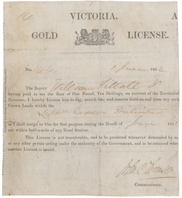 Old Colonists' Association of Ballarat Inc.
Document - Gold License, Gold License Issued to William Fittall in the Upper Loddon District, 1851, 10/1851
This miner's right is a copy from an original held by the Old Colonists' Association of Ballarat. The original was glued onto a page in a large album of photographic images of early Ballarat. Recognising their significance the Council of the Old Colonists’ Association had them removed and restored. The originals are now framed and on display in the Old Colonists’ Hall.Digital image of an original gold license made out to William Fittall Junior.14 Victoria Gold License No 144 1 June 1852 The Bearer William Fittall Jr having paid to me the sum of One Pound, Ten Shillings, on account of the territorial revenue, I hereby License him to dig, search for, and removed Gold on and from any such Crown lands within the Upper Loddon District as I shall assign to him for that purpose during the Month of June 1852 not within half-a-mile of any Head Station. This License is not transferrable, and to be produce whenever demanded by me or any other person acting under the authority of the government, and to be returned when another License is issued. [Undecipherable signature] Commissionerwilliam fittall, upper loddon, mining, old colonists' association, fittall, eureka -
 Kiewa Valley Historical Society
Vaporiser Cresolene, circa late1800's to early 1900's
This Cresolene vapouriser is an "American" product when "home" based remedial products were of a high demand due to lack of specialised medical facilities such as a hospital in rural communities. "An apparatus for reducing medicated liquids to a state of vapor suitable for inhalation or application to accessible mucous membrane A device for volatising liquid anesthetics." The only criteria used by Health authorities in the decision to provide a community with hospitals was and still is the size of the population it feeds. The introduction of the SEC Victorian Hydro Electricity Scheme started in the 1940's, was the impetus for health planners to build a hospital in the Kiewa Valley. Rural regions especially those considered semi or fully remote locations had to rely on farm based remedial health "alternative medical treatment". This product is such a remedy.This vapouriser is very significant to a rural area such as the Kiewa Valley as it demonstrates the "home" remedies that were available to rural communities such as the cattle and sheep stations before the Kiewa Valley had a hospital(1949). The influx of workers employed by the SEC Vic. Hydro Electricity Scheme(circa 1940's onward) changed dramatically the need for a hospital and specialised medical treatment. The reliance of "health products" such as this vaporiser were still in high demand especially when on the box of this product was printed "Guaranteed under the Food and Drugs Act, June 30, 1906, Serial no. 436". Also on the packaging is printed "A remedy Whooping Cough also Asthma, Catarrh, Colds Diptheria, Croup, Coughs Hay Fever, Sore Throat, Influenza, Etc." An additional benefit of this product "Is obnoxious to Moths, Flies, Mosquitos, Ants, Cock Roaches, Hen Lice, and other Troublesome insects." This advertising is dated before a tightening in the "advertising" legislation of post mid 1900's. However it was a good attraction for rural communities wanting relief of "rural" pests. This vaporiser stand with its cradle and dish is made from cast iron (stand) and tin (dish). At the bottom of the "dish" is a flame diffusion port with eight heat directional holes. The stand upright is painted gold in colour.See KVHS 0342 (B) for markings and advertising material printed on the box which contains this item.home based vaporisers, first aid, home nursing, over-the-counter medicines -
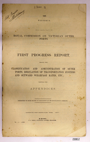 Flagstaff Hill Maritime Museum and Village
Document, Royal Commission on Vicrorian Outer Ports, 1925
This first progress report dealing with classification and administration of Victoria's outer ports, regulation of transportation systems and outward wharfage rates etc., together with appendices, was presented "To His Excellency Colonel the Right Honorable George Edward John Mowbray, Earl of Stradbroke ... Governor of the State of Victoria", to both Houses of Parliament by His Excellency's Command in 1925. TRANSCRIPTION of front cover = = = = = = = = 1925. VICTORIA. ROYAL COMMISSION ON VICTORIAN OUTER PORTS. FIRST PROGRESS REPORT, DEALING WITH CLASSIFICATION AND ADMINISTRATION OF OUTER PORTS, REGULATION OF TRANSPORTATION SYSTEMS AND OUTWARD WHARFAGE RATES, ETC.; TOGETHER WITH APPENDICES. PRESENTED TO BOTH HOUSES OF PARLIAMENT BY EXCELLENCY’S COMMAND. Approximate Cost of Report. – Preparation not given. Printing ( copies) £ By Authority: H. J. GREEN, GOVERNMENT PRINTER, MELBOURNE = = = = = = = = This document represents the process of the Parliament of Victoria to examine matters of importance to the people and situations in Victoria. In particular this document is the beginning of the examination of the situation with the transportation and cost of freight in outer ports of Victoria. The results of the Royal Commission could have a major impact on those ports and the services that are offered.First Progress Report, Parliament of Victoria, - Royal Commission on Victorian Outer Ports, 1925. Printed and published for the Government of Victoria by H.J. Green, Government Printer, Melbourne.Handwritten on top left corner “With Compts. [signature]”flagstaff hill, warrnambool, shipwrecked-coast, flagstaff-hill, flagstaff-hill-maritime-museum, maritime-museum, shipwreck-coast, flagstaff-hill-maritime-village, royal commission 1925, regulation of transport systes, regulation of outward wharfage rates, victorian outer ports development, legal document, regulation of transport systems and rates, victorian transport systems -
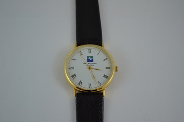 Melbourne Water
Melbourne Water Watch, 1996
As the Yarra became unsuitable as a source of water, several attempts were made to find alternative sources for the growing population of Melbourne. It was not until 1891 that the efforts to sewer Melbourne came to fruition with the setting up of the Melbourne Metropolitan Board of Works (MMBW), now known as Melbourne Water. From 1891 until 1992, it was the responsibility of the MMBW to safeguard public health by providing a sewerage system and a safe water supply system. In 1992, The MMBW merged with a number of smaller urban water authorities to form Melbourne Water. This Melbourne Water watch was gifted to a Melbourne Water staff member by her manager when she left the organisation in 1996. The watch was part of a branding campaign as the water industry became segregated in 1994.This item is of historical significance for its association with Melbourne Water at the time when the water industry became segregated in 1994. This watch is a perfectly intact object and is significant for its representativeness of the theme of Women in the Workforce within the MMBW and Melbourne Water as it was gifted to a female employee. The watch is also aesthetically pleasing in style and represents the trends of the 1990s. Gold plated, black leather band watch with the Melbourne Water logo on the face with accompanying black suede case with gold corners. The watch also comes with a warranty inside.melbourne metropolitan board of works, mmbw, melbourne water, watch, accessory, gift -
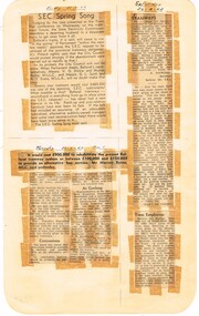 Ballarat Tramway Museum
Newspaper, State Electricity Commission of Victoria (SEC) and The Courier Ballarat, SEC Spring Song, Feb. 1962
Yields information about the views of various letter writers, views of the Courier, union views, rehabilitation costs and employment.Foolscap sheet of plain paper, with rounded corners, with 4 newspaper cuttings, concerning the mooted closure of the Ballarat Tram system 28 Feb and 2 March 1962. All from The Courier, unless noted otherwise. 1 - "SEC Spring Song" - 23/2/62 - Editorial - about the SEC actions to desert Ballarat, Council meeting with Parliamentary representatives, cost of new cars and always a second-hand place. 2 - "Tramways" - 24-2-62 - letter by R. Courtney, Union Secretary, re use of new trams, one-man cars and Mr. Mawby's jet propelled buses. 2nd letter, written by a car driver, lamenting the closure, employment of trammies and SEC 3 - Untitled article - 27/2/62 - cost of rehabilitating the system given compared to buses, cost estimate from TRB, concessions (not to Pensioners), bus routes in Geelong, people preferred any replacement bus service to be run by a public authority. 4 - "Tram Employees" - 24-2-1962 - SEC would find alternative employment for the displaced tramway workers.closure, letter to the editor, editorial, sec, rehabilitation, staff, buses, concession fares -
 Bendigo Historical Society Inc.
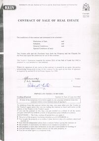
Document - PETER ELLIS COLLECTION: CONTRACT OF SALE
Copy of Contract of Sale of Real Estate and associated papers for property located in Flora Lane, Flora Hill which was purchased by Peter Ellis on 26 May 1993. Contract is in booklet with other loose papers. Contract includes General Conditions, Particulars of Sale, Special Conditions, Guarantee, Vendors Statement to the Purchaser, Shire of Strathfieldsaye Land Information Certificate, Planning Certificate Request for Building Approval Particulars, Coliban Region Water Authority Information Statement, Property Inquiry Application Form, Request for Property Information from Vic roads, Advice on Mine Subsidence Hazard (Department of Energy & Minerals), Map, Copy of Certificate of Title and Folder Numbers. Loose pages include Building Control Act 1981 Inspection Notice, two plans of building, Three plans (Coliban Water Asset Location) of Flora Lane where property is situated, 2 dated 13/11/2007 (have New Carport drawn beside house) and 1 dated 22/11/2007. Last page has specifications for car port.bendigo, house, peter ellis oam, peter ellis collection, reiv, law institute of victoria, real estate institute of victoria ltd, e j gannaway, peter n ellis, ray white bendigo pty ltd, e m monotti & son, rogers and every, craig watts, shire of strathfieldsaye, coliban region water authority, sec, g & fc of vic, telecom, vicroads, bruce l phillips, k deps?, department of energy and minerals, robert james sanderson, t flanagan, land titles office victoria, harston partridge & co pty ltd -
 Bendigo Historical Society Inc.
Document - DRAINAGE PROBLEMS - NEW CHUM MINES DRAINAGE PROBLEMS 1910
Handwritten extract from the Bendigo Advertiser 20/8/1910 Page 8. ''New Chum Mines. Unwatering of the deep levels is being carried on as expeditionsly as was expected by the authorities. In the last four days, the water has only been lowered 14 feet at the Victoria Quartz Mine. The water stood at the 3,226 feet level yesterday. The slow progress being made this week is no doubt due to the large quantity in the workings at some of the levels.'' From the Bendigo Advertiser 27/8/1910 Page 9. ''New Chum Mines. Very slow progress being made. At Victoria Quartz, the water was lowered 32 feet for the week, and is now at 3258 feet. New Chum Railway lowered the water 17 feet and the present level of the water is at 1796 feet. The Lazarus are raising water from 2157 feet. The water has ceased flowing into the New Chum and Victoria through the connecting level with the Lazarus Mine at about 2,500 feet. As the Victoria Quartz is down 4,614 feet, there is still a considerable quantity of water to get out before sinking of the shaft can be resumed.''document, gold, drainage problems, drainage problems, new chum mines drainage problems 1910, bendigo advertiser 20/8/1910 page 8 & 27/8/1910 page 9, new chum mines, victoria quartz, new chum railway, lazarus, new chum and victoria -
 Melbourne Tram Museum
Magazine, The Met, "Matinees - Vol 1, No. 9 December 1985", Dec. 1985
Magazine - 20 A4 pages centre stapled - titled "MetLines - Vol 1, No. 9 December 1985", staff newspaper of the Metropolitan Transit Authority. Has a number of "Santa Claus" on the front cover. Contains an article on page 8, "Keeping tram lines clean" and "Scrubber Cars" - featuring Frank Reale-Key posing in front of Scrubber 8W. Also has a photo of scrubber No. 11. Gives a background to the cars, when they are used, operated by Civil Branch. Gives hours of use and crews. Another item is "Tram centenary celebrations a success" - Event and cavalcade of trams on 11/11/1985, celebrating the commencement of the cable car services in Melbourne. Notes the unveiling of a plaque by Mr Roper, assisted by Keith Kings of the TMSV. Other items tramway related are the celebration - 70th marriage celebration of Harry Heaton who worked at Preston, Glenhuntly depot cricket team and on the rear cover a photo of Norm Maddock at the Picnic function at Wattle Park. On page 3 is a follow up to a question on a MTOC conductor with the large safety pins of the era. Not all pages scanned.trams, tramways, scrubber tram, the met, conductors, track, mto co, centenary, cable trams, cavalcade, tram 8, tram 11 -
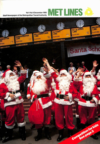
 The Beechworth Burke Museum
Photograph, Late 1800s
This photograph depicts six men and two horses with carts in the process of constructing a road. The men each stand in a relatively relaxed position, posing for the camera. However, the amount of upturned soil surrounding them suggests the hard work they have endured, armed only with pitchforks and shovels. The creation of new roads in the Beechworth area had become a priority for the Beechworth council in the second half of the nineteenth century. This included connecting roads which radiated out of Beechworth to surrounding towns. This led to the expansion of the local government authority over the surrounding countryside, greatly strengthening Beechworth's central position. The use of horse and cart to take away the removed soil, as well as the style of the men's attire, suggests that this photograph dates back to the late 1800s. It can also be assumed that this photograph was taken somewhere in the surrounding hills of Beechworth. This photograph is historically significant as it provides insight into the rapid expansion of roads in and around Beechworth during the second half of the nineteenth century. Sepia rectangular photograph on matte photographic paper mounted on card Reverse: BMM 2982 / road construction, beechworth roads, 1800s, 1800s beechworth, beechworth hills, horse and cart, beechworth road making, beechworth council roads, road expansion, beechworth surrounding hills -
 Glen Eira Historical Society
Article - Brighton Cemetery, North Road, Caulfield South
This file contains two items about war graves. 1/A two-page newspaper article from the "Herald Sun" of 31/07/2011 concerning the neglected state of the graves of some Victoria Cross winners and other war heroes at several cemeteries in Melbourne including Brighton Cemetry. The article notes that the Dept of Veterans' Affairs and other authorities are not adequately maintaining the graves. Includes photographs. 2/A newspaper article from Glen Eira/Port Phillip Leader dated 12/02/2013. The article makes mention that a Gallipoli soldier will finally receive an official war grave and commemorative service in April 2013. Local war historian Carl Johnson stepped in to help and the Australian War Graves will install a grave marker to Pte. Jack Alexander Johnson.brighton cemetery, caulfield south, buckley maurice, joynt william donovan, newland james ernest, peeler walter, graves, cemetries, medals, war veterans, monuments and memorials, war memorials, world war 1914-1918 world war 1939-1945, johnson jack alexander, caulfield military hospital, hospitals, johnson carl, johnson bill, historical markers -
 Federation University Historical Collection
Book - Booklet, Soldiering On: The Australian Army at Home and Overseas, 1942
Belonged to Clarence (Clarrie) Edward Nicholls who was a communications person on the Sunderland Flying Boats. He was in the Battle of Britain. He was seconded to the RAF and flew out of Plymouth. He was shot down a number of times. He was in the peace keeping corps in Japan and then Korea, and then went into the full time Korea. At one time Clarrie and his two brothers were in New Guinea at the same time. They knew they were all there together but they could not find each other, and officials would not tell them where they were. He flew the last Sunderland back to Lake Boga. He wanted to buzz his parents in Wodonga so he knew he was on the way, but the authorities wouldn't let him. Clarrie Nicholls was a flag bearer for the Melbourne Olympics.Red hard covered book of 200 pages. The following images are by official war artist Geoff Mainwaring (SX13471) who later taught painting at the Ballarat Technical Art School. * 'And Again. So-Heave', page 121 * 'Day's Work Done', page 121 * Untitled image, pg 185 Includes photographs of General Sir Thomas Blamey, Corporal Jim Gordon, John Lavarack, Iven Maccay, Australian Women's Army Service, Convalescent Diggers at Heidelberg Hospital; and maps of the Malay Peninsula and Singapore.clarence nicholls, nicholls, world war 2, geoffrey mainwaring, new guinea, singapore, libya, solomon islands, charles bush, ivor heale, g.j. browning -
4th/19th Prince of Wales's Light Horse Regiment Unit History Room
Medal, Elizabeth II Coronation 1953
The Queen Elizabeth II Coronation Medal was a commemorative medal made to celebrate the coronation of Queen Elizabeth II. For Coronation and Jubilee medals, the practice up until 1977 was that the authorities in the United Kingdom decided on a total number to be produced, then allocated a proportion to each of the Commonwealth countries and Crown dependencies and other possessions of the Crown. The award of the medals was then at the discretion of the government of each territory, which was left free to decide who got a medal and why. A total of 138,214 medals were issued, including: 11,561 to Australians 12,500 to Canadians Ladies awarded the medal can wear it on their left shoulder with the ribbon tied in the form of a bow. The medals were issued without inscription except for the 37 issued to the British Mount Everest Expedition. These were engraved MOUNT EVEREST EXPEDITION on the rim.Miniature medal with ribbon. The full size medal is a circular, silver medal, 1.25 inches in diameter. The obverse features a crowned effigy of Queen Elizabeth II, in a high-collared ermine cloak and wearing the collar of the Garter and Badge of the Bath, and facing right. There is no raised rim and no legend. The reverse shows the Royal Cypher EIIR surmounted by a large crown. The legend around the edge reads QUEEN ELIZABETH II CROWNED 2nd JUNE 1953. The dark red ribbon is 1.25 inches (32 mm) wide, with two narrow dark blue stripes (0.09375 inches {3/32"} wide) in the centre (0.0625" apart) and narrow white stripes (0.0625") at each edge. medal elizabeth coronation -
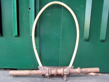 Puffing Billy Railway
hoop, Staff exchanger
Staff exchanger hoop - Leather Bakelite and wooden prop staff. The hoop held the 'Staff’ giving authority for a locomotive or rail vehicle permission to travel over a specified section of track. The display shows the hand held type used from person to person. Hand held staffs were exchanged at low speeds or stationary. Automatic staff exchangers were also in use when a vehicle was not required to travel at low speed to exchange the staffs and were used by express trains. To exchange the 'Staff’ from the platform or signal box to the locomotive driver, the hoop was held up in the air by the person, and collected by the Drivers arm. The reverse occurred when the staff was being given by the Driver. Both exchanges may occur where one section of line ends and another commences.Historic - Railways - Staff exchanger hoop - used for person to person exchanging.Staff exchanger hoop made of Leather Bakelite and wooden prop staffpuffing billy, staff exchanger hoop -
 Uniting Church Archives - Synod of Victoria
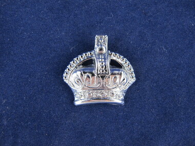
Uniform - Symbol of Office, Past Knight/Esquire/Page Commander
Symbol: A crown, symbol of authority, indicated that the wearer has occupied the chair of King Arthur. This was worn over the emblem of any office to which he may have been appointed to later. How elected: Automatically, by virtue of having been a Knight/Esquire/Page Commander. Duties: To share with his successor the advice and experience gained during his own term and to set an example to more junior members. The reward for loyal Christian service is more service and it is the duty of the Past Knight Commander to make available his counsel and experience to his successor. This does not mean running the Court from the back seat. It means taking an active interest in the Court and Companions and being always readily available to help where required. [Leadership Training Handbook 1968, pg 15]Metal crown x 4.methodist order of knights -
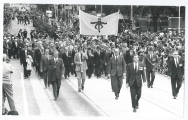 Melbourne Legacy
Photograph, Anzac Day 1973, 1973
00391.1 Photograph of a group of men, led by President Geoff Handbury, marching behind a Legacy Banner nearing the corner of Swanston St and Flinders Lane, Melbourne en route to the Shrine of Remembrance for ANZAC Day 1973. 1973 was the Golden Jubilee Year when Legacy celebrated their 50th anniversary. It appears they needed approval from the RSL to march on Anzac Day. 00391.2 Photo of part of the group of men marching. 00391.3 Photo of part of the group of men marching closer up. 00391.2 and 00391.3 came from a Legacy envelope marked "P1" in red pen, with assorted photos of major events such as 1973 Federal Conference, 1983 Morwell, 1973 Legacy march Anzac Day, 50 year celebration inclusion in Anzac Day March, with authority of RSL (some are items 00440 to 00442).A record of Legacy marching in an ANZAC Day parade on the 50th anniversary of Legacy.Black and white photo x 3 of Legatees marching along St Kilda Road.Handwritten 'Legacy Contingent Anzac Day 1973' in blue pen, 'The Legacy contingent at the 1973 Anzac Day March in Melbourne. The group of ex-servicemen is led by the Legacy President, Mr Geoff Handbury.' in black pen, stamped 'Property of Melbourne Legacy' in purple ink, on the first photo of the entire march. Handwritten 'ANZAC Day 25 April 1973' in blue pen on reverse of the close up photos.golden jubilee, anzac day, march, 50th anniversary -
 Falls Creek Historical Society
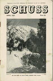
Journal - Schuss Vol. 17. No. 4 April 1951
Schuss was advertised as Victoria’s Official Ski Journal It was issued monthly from 1935 to 1961 except during the war when summer issues covered two months. This continued after the war, but it averaged 10 issues annually over its 25 year life. Schuss was published by the Ski Club of Victoria which had a membership of 38 Ski Clubs and demanded to be recognised as the prime authority on skiing in the state. The other 30 ski clubs with 85% of the members disagreed and the politics of skiing became heated. These clubs formed the Federation of Victorian Ski Clubs with their own journal, Ski Horizon. With the establishment of the Victorian Ski Association, Ski-Horizon published its last issue in Nov - Dec. 1955 and the role of the official journal was fully taken over by “Schuss”. This item is significant because it contains stories, images and information documenting the development of the ski industry in Victoria.The journal features stories and events chronicling developments in Victoria and internationally. Items related to the Falls Creek Area in this issue include:- Cover - Features a photo by H.Gibbs titled "On the road to Falls Creek, Bogong High Plains"schuss journal, the ski club of victoria -
 Falls Creek Historical Society
Journal - Schuss Vol. 17. No. 7 July 1951
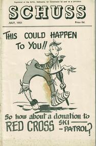
Schuss was advertised as Victoria’s Official Ski Journal It was issued monthly from 1935 to 1961 except during the war when summer issues covered two months. This continued after the war, but it averaged 10 issues annually over its 25 year life. Schuss was published by the Ski Club of Victoria which had a membership of 38 Ski Clubs and demanded to be recognised as the prime authority on skiing in the state. The other 30 ski clubs with 85% of the members disagreed and the politics of skiing became heated. These clubs formed the Federation of Victorian Ski Clubs with their own journal, Ski Horizon. With the establishment of the Victorian Ski Association, Ski-Horizon published its last issue in Nov - Dec. 1955 and the role of the official journal was fully taken over by “Schuss”. This item is significant because it contains stories, images and information documenting the development of the ski industry in Victoria.The journal features stories and events chronicling developments in Victoria and internationally. Items related to the Falls Creek Area in this issue include:- Page 256 - Explanation of the A.N.S.F. tests and results. Instructions for Test Judges are also included. Mrs. S. St. Elmo is listed as a judge. Page 263 - All skiers visiting Bogong High Plains must comply strictly with the requirements of the State Electricity Commission in regard to transport and general activities in the area. The detailed regulations were set out in the following page.schuss journal, the ski club of victoria, skippy st. elmo, sec regulations -
 Falls Creek Historical Society
Journal - Schuss Vol. 17. No. 8 August 1951
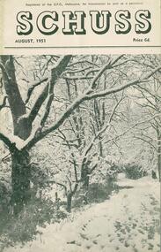
Schuss was advertised as Victoria’s Official Ski Journal It was issued monthly from 1935 to 1961 except during the war when summer issues covered two months. This continued after the war, but it averaged 10 issues annually over its 25 year life. Schuss was published by the Ski Club of Victoria which had a membership of 38 Ski Clubs and demanded to be recognised as the prime authority on skiing in the state. The other 30 ski clubs with 85% of the members disagreed and the politics of skiing became heated. These clubs formed the Federation of Victorian Ski Clubs with their own journal, Ski Horizon. With the establishment of the Victorian Ski Association, Ski-Horizon published its last issue in Nov - Dec. 1955 and the role of the official journal was fully taken over by “Schuss”. This item is significant because it contains stories, images and information documenting the development of the ski industry in Victoria.The journal features stories and events chronicling developments in Victoria and internationally. Items related to the Falls Creek Area in this issue include:- Page 304 - A meeting held at Bogong to which all clubs with Permissive Occupancies in Falls Creek were invited has agreed to form an Advisory Council. This body would be known as the "Falls Creek Alpine Village Advisory Committee. Each club was to have one representative and one vote. Suggested matters to be dealt with by the Committee included (a) Development of the village, (b) General Conduct and (c) Safety. Page 316 - An advertisement for Nissen Ski School with the slogan "Speed is the Thrill, COntrol the Art."schuss journal, the ski club of victoria -
 Falls Creek Historical Society
Journal - Schuss Vol. 17. No. 10 November - December 1951
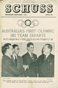
Schuss was advertised as Victoria’s Official Ski Journal It was issued monthly from 1935 to 1961 except during the war when summer issues covered two months. This continued after the war, but it averaged 10 issues annually over its 25 year life. Schuss was published by the Ski Club of Victoria which had a membership of 38 Ski Clubs and demanded to be recognised as the prime authority on skiing in the state. The other 30 ski clubs with 85% of the members disagreed and the politics of skiing became heated. These clubs formed the Federation of Victorian Ski Clubs with their own journal, Ski Horizon. With the establishment of the Victorian Ski Association, Ski-Horizon published its last issue in Nov - Dec. 1955 and the role of the official journal was fully taken over by “Schuss”. This item is significant because it contains stories, images and information documenting the development of the ski industry in Victoria.The journal features stories and events chronicling developments in Victoria and internationally. Items related to the Falls Creek Area in this issue include:- Cover - Australia's First Olympic Ski Team Departs - features a photo from "The Age" Derrick Stogdale, President of the Ski Club of Victoria, conveys the good wishes of Victorian skiers to Olympic team members, Bruce Haslingdon, Cedric Sloane and Bill Day. The team consisted of Captain-Manager R.G. Chisholm (Chairman, S.C.V. Racing Sub-Committee), W. Day (N.S.W.), B. Haslingdon (N.S.W.), R. Arnott (Vic), T. Aslangu (Vic) since withdrawn. Page 383 - Falls Creek Reminiscence - Australia - New Zealand Meeting 1951 gives a detailed recount of the events and activities held during a two week visit to Falls Creek by the New Zealand teadmschuss journal, 1952 winter olympic ski team, inter-dominion event 1951 -
 Falls Creek Historical Society
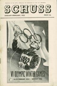
Journal - Schuss Vol. 18. No. 1 January - February 1952
Schuss was advertised as Victoria’s Official Ski Journal It was issued monthly from 1935 to 1961 except during the war when summer issues covered two months. This continued after the war, but it averaged 10 issues annually over its 25 year life. Schuss was published by the Ski Club of Victoria which had a membership of 38 Ski Clubs and demanded to be recognised as the prime authority on skiing in the state. The other 30 ski clubs with 85% of the members disagreed and the politics of skiing became heated. These clubs formed the Federation of Victorian Ski Clubs with their own journal, Ski Horizon. With the establishment of the Victorian Ski Association, Ski-Horizon published its last issue in Nov - Dec. 1955 and the role of the official journal was fully taken over by “Schuss”. This item is significant because it contains stories, images and information documenting the development of the ski industry in Victoria.The journal features stories and events chronicling developments in Victoria and internationally. Items related to the Falls Creek Area in this issue include:- Cover - Image acknowledging the Australian team in the Oslo Winter Olympics Page 31 - TRANSPORT TO FALLS CREEK - Following press reports in recent months regarding curtailment of the work of the State Electricity Commission on Bogong High Plains, there will be no snow clearing on the road above Howman's Gap next winter, and possibly no snow clearing at all. Traffic will not be permitted to proceed where no clearing is being carried out. Apart from this, it is hoped that it will not be necessary to curtail any further the general arrangements in force last winter. During this summer the road will be closed to visitors generally, but arrangements will be made for working parties at ski huts to proceed to or from Falls Creek between 8 a.m. and 5 p.m. on Saturdays and Sundays only, provided that prior arrangements have been made.winter olympics 1952, road access to falls creek 1952