Showing 42388 items matching "were"
-
 Bendigo Historical Society Inc.
Map - GREAT EXTENDED HUSTLER'S MINE - TRANSVERSE SECTION OF THE GREAT EXTENDED HUSTLER'S MINE
Transverse Section of the Great Extended Hustler's Mine on the Hustler's Line of Reef. Bulletin No 33, Plate No XII. Shows Poppet legs at the surface and Sill of Shaft at 788.99 feet above Sea Level, Cross Cuts and their depths, stone and geographical features encountered and their references and a number of enlarged drawing of sections of the crosscuts, Geological Survey of Victoria emblem and signed by H A Whitelaw, Underground Survey Office Bendigo, September 1913. The depths of crosscuts to No 21 were taken from plans of surveys by Mr. Walker and Mr. Craven, noted under Reference. Another note: This Saddle Reef is sketched from Mr. Walker's plan. Dividends amounting to 360,000 pounds were obtained from it. mining, parish map, great extended hustler's mine, transverse section of the great extended hustler's mine, old shaft, mr walker, mr craven, geological survey of victoria, underground survey office bendigo, h a whitelaw -
 Bendigo Military Museum
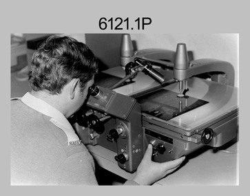
photograph - Aerotriangulation Production – Army Survey Regiment, Fortuna, Bendigo, c1980
This collection of five photos was most likely taken in 1980. Wild PUG4 point transfer devices were used by technicians in Air Survey Squadron to stereoscopically view the photography containing the survey control points and the mapping aerial photography. The Control points were transferred from the control photography to the mapping diapositives of aerial photography by drilling their locations into the photographic emulsion. The Zeiss (Jena) Stecometer analytic stereocomparator for air photography was introduced at Air Survey Squadron in 1963. Aerotriangulation production was expedited using computers for analytical photogrammetric processes. The technician accurately measured between pass, tie, and survey control points on aerial photographs.Air Survey Squadron Aerotriangulation Section - Army Survey Regiment, Bendigo. c1980. This is a set of five photographs of Air Survey Squadron personnel operating aerotriangulation equipment at the Army Survey Regiment at Fortuna, Bendigo, c1980. Photographs .1P to .4P are on 35mm negative film and were scanned at 96 dpi. Black and white photo .5P is on photographic paper and was scanned at 300 dpi. They are part of the Army Survey Regiment’s Collection. .1) - Photo, black & white, c1980, Wild PUG4 point transfer device, unidentified technician. .2) - Photo, black & white, c1980, Wild PUG4 point transfer device, unidentified technician. .3) - Photo, black & white, c1980, Wild PUG4 point transfer device, unidentified technician. .4) - Photo, black & white, c1980, Zeiss (Jena) Stecometer, unidentified technician. .5) - Photo, black & white, c1980, Zeiss (Jena) Stecometer..1P to .5P No personnel are identified.royal australian survey corps, rasvy, army survey regiment, army svy regt, fortuna, asr, air survey, aerotrig -
 Kew Historical Society Inc
Plan, Melbourne and Metropolitan Board of Works, Borough of Kew : Detail Plan No.1562, 1905
The Melbourne and Metropolitan Board of Works (MMBW) plans were produced from the 1890s to the 1950s. They were crucial to the design and development of Melbourne's sewerage and drainage system. The plans, at a scale of 40 feet to 1 inch (1:480), provide a detailed historical record of Melbourne streetscapes and environmental features. Each plan covers one or two street blocks (roughly six streets), showing details of buildings, including garden layouts and ownership boundaries, and features such as laneways, drains, bridges, parks, municipal boundaries and other prominent landmarks as they existed at the time each plan was produced. (Source: State Library of Victoria). This plan forms part of a large group of MMBW plans and maps that was donated to the Society by the Mr Poulter, City Engineer of the City of Kew in 1989. Within this collection, thirty-five hand-coloured plans, backed with linen, are of statewide significance as they include annotations that provide details of construction materials used in buildings in the first decade of the 20th century as well as additional information about land ownership and usage. The copies in the Public Record Office Victoria and the State Library of Victoria are monochrome versions which do not denote building materials so that the maps in this collection are invaluable and unique tools for researchers and heritage consultants. A number of the plans are not held in the collection of the State Library of Victoria so they have the additional attribute of rarity.Original survey plan, issued by the MMBW to a contractor with responsibility for constructing sewers in the area identified on the plan within the Borough of Kew. The plan was at some stage hand-coloured, possibly by the contractor, but more likely by officers working in the Engineering Department of the Borough and later Town, then City of Kew. The hand-coloured sections of buildings on the plan were used to denote masonry or brick constructions (pink), weatherboard constructions (yellow), and public buildings (grey). MMBW detail plan No.1562, in contrast to No.1561 includes the names of a large number of houses: in Barkers Road: ‘Ashwick’, ‘Owasso’, ‘Anadiha’, ‘Eurobin’, ‘Carlsruhe’, ‘Arlington’ and ‘Altyre’. Unnamed but clearly represented on the plan is what was then known as the ‘Auburn Heights Recreation Club’, which at this stage included a Bowling Green, a Croquet Green and two Tennis Courts. On the plan, Brougham Place, as it was then known, is represented. It was later renamed Daniell Place. The aforementioned Arlington is now the junior campus of Preshil. melbourne and metropolitan board of works, detail plans, mmbw 1562, cartography -
 Kew Historical Society Inc
Plan - Subdivision Plan, Harvest Home Estate, 1919
Pru Sanderson, in her groundbreaking ‘City of Kew Urban Conservation Study : Volume 2 - Development History’ (1988), summarised the periods of urban development and subdivisions of land in Kew. The periods that she identified included 1845-1880, 1880-1893, 1893-1921, 1921-1933, 1933-1943, and Post-War Development. These periods were selected as they represented periods of rapid growth or decline in urban development. An obvious starting point for Sanderson’s groupings involved population growth and the associated economic cycles. These cycles also highlighted urban expansion onto land that was predominantly rural, although in other cases it represented the decline and breakup of large estates. A number of the plans in the Kew Historical Society’s collection can also be found in other collections, such as those of the State Library of Victoria and the Boroondara Library Service. A number are however unique to the collection.The Kew Historical Society collection includes almost 100 subdivision plans pertaining to suburbs of the City of Melbourne. Most of these are of Kew, Kew East or Studley Park, although a smaller number are plans of Camberwell, Deepdene, Balwyn and Hawthorn. It is believed that the majority of the plans were gifted to the Society by persons connected with the real estate firm - J. R. Mathers and McMillan, 136 Cotham Road, Kew. The Plans in the collection are rarely in pristine form, being working plans on which the agent would write notes and record lots sold and the prices of these. The subdivision plans are historically significant examples of the growth of urban Melbourne from the beginning of the 20th Century up until the 1980s. A number of the plans are double-sided and often include a photograph on the reverse. A number of the latter are by noted photographers such as J.E. Barnes.The ‘Harvest Home Estate’ was advertised as being a subdivision in East Kew. Now, Campbell and Owen Streets on which the allotments were located are classed as being in Kew. The Estate included 11 residential allotments abutting the Outer Circle Railway line [at the end of Owen Street]. Understandably, the vendors focused on the availability of transport by tram, noting that the Estate was near the High Street tram terminus at the Harp of Erin. A small note on the subdivision advises that the Cotham Road tram was only 3 minutes away. The location – ‘The most elevated position in lovely Kew’ – was also promoted as an advantage.subdivision plans - east kew, harvest home estate -
 Kew Historical Society Inc
Plan - Subdivision Plan, Plan of Subdivision of Crown Portion 71, Parish of Boroondara LP12509, Vol.1678, Fol.335526, Before 1930
Prue Sanderson, in her groundbreaking ‘City of Kew Urban Conservation Study : Volume 2 - Development History’ (1988), summarised the periods of urban development and subdivisions of land in Kew. The periods that she identified included 1845-1880, 1880-1893, 1893-1921, 1921-1933, 1933-1943, and Post-War Development. These periods were selected as they represented periods of rapid growth or decline in urban development. An obvious starting point for Sanderson’s groupings involved population growth and the associated economic cycles. These cycles also highlighted urban expansion onto land that was predominantly rural, although in other cases it represented the decline and breakup of large estates. A number of the plans in the Kew Historical Society’s collection can also be found in other collections, such as those of the State Library of Victoria and the Boroondara Library Service. A number are however unique to the collection.Subdivision plans are historically important documents used as evidence of the growth of suburbs in Australia. They frequently provide information about when the land was sold on which a built structure was subsequently constructed as well as evidence relating to surveyors and real estate and financial agents. The numerous subdivision plans in the Kew Historical Society's collection represent working documents, ranging from the initial sketches made in planning a subdivision to printed plans on which auctioneers or agents listed the prices for which individual lots were sold. In a number of cases, the reverse of a subdivision plan in the collection includes a photograph of a house that was also for sale by the agent. These photographs provide significant heritage information relating house design and decoration, fencing and household gardens.The six lots on the south side of Macartney Avenue, between Macartney Avenue and Daniell Place were part of a subdivision that occurred before 1930. The subdivision plan is of interest in that the original name of Daniell Place was Brougham Place. On the Plan, it is noted that lots 5 and 6 (currently 10 and 12 Macartney Avenue) had been sold for £13 each. By November 1930, the new six-roomed villa built on 12 Macartney Avenue was offered for immediate sale at a ‘sacrifice price’. Any offer in reason would be considered, although a £350 deposit was required.subdivision plans - kew, mount street - kew, brougham street - kew , macartney avenue - kew -
 Frankston RSL Sub Branch
Glass, Souvenir
A pair of small wine glasses, perhaps sherry glasses. These glasses have the image of the new Frankston Returned & Services League of Australia club building and were made for the 1st anniversary of the opening which was celebrated in 1977. These glasses are made from clear glass and are embellished in gold leaf, the glasses are gold lipped.The glasses are inscribed with the following in gold leaf: "1st ANNIVERSARY 1977" and the image of the new club building with the words "FRANKSTON RSL". -
 Bendigo Historical Society Inc.
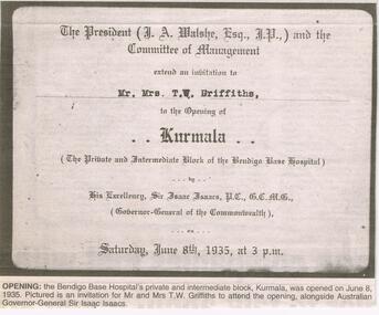
Newspaper - JENNY FOLEY COLLECTION: OPENING
Bendigo Advertiser '' The way we were'' from 2002. Opening: the Bendigo Base Hospital's private and intermediate block, Kurmala, was opened on June 8, 1935. Pictured is an invitation to Mr. and Mrs. T. W. Griffiths to attend the opening, alongside Australian Governor-General Sir Isaac Isaacs. The clip is in a folder.newspaper, bendigo advertiser, the way we were -
 Bendigo Historical Society Inc.
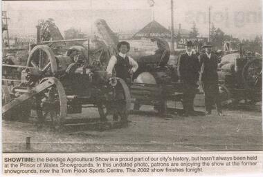
Newspaper - JENNY FOLEY COLLECTION: SHOWTIME
Bendigo Advertiser '' The way we were'' from 2002. Showtime: the Bendigo Agricultural Show is a proud part of our city's history, but hasn't always been held at the Princes of Wales Showgrounds. In this undated photo, patrons are enjoying the show at the former showgrounds, now the Tom Flood Sports Centre. The clip is in a folder.newspaper, bendigo advertiser, the way we were -
 Bendigo Historical Society Inc.
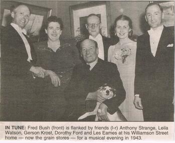
Newspaper - JENNY FOLEY COLLECTION: IN TUNE
Bendigo advertiser '' The way we were'' from 2002. In tune: Fred Bush (front) is flanked by friends 9Left to right) Anthony Strange, Leila Watson, Gerson Krost, Dorothy Ford and Les Eames at his Williamson Street home - now the grain stores - for a musical evening in 1943. The clip is in a folder.newspaper, bendigo advertiser, the way we were -
 Bendigo Historical Society Inc.
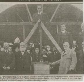
Newspaper - JENNY FOLEY COLLECTION: A NEW BEGINNING
Bendigo Advertiser ''The way we were'' from 2000. W.G. Stephens, president of the Baptist Union, lays the foundation stone of the new Baptist Church at Eaglehawk. Others in the picture include Rev. S.J. Goble, F. Morris, F.Foot, and Rev. Boreham. Picture courtesy of the Bendigo Historical Society. The clip is in a folder.newspaper, bendigo advertiser, the way we were -
 Bendigo Historical Society Inc.
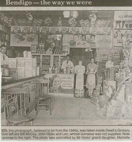
Newspaper - JENNY FOLEY COLLECTION: DEWIT'S GROCERY
Bendigo Advertiser ''The way we were'' from 2000. This photograph, believed to be from the 1940s, was taken inside Dewit's Grocery. From left are Bill McCoy, John Hicks and Len, whose surname was not supplied. Note the women to the right. The photo was submitted by Mr. Hicks' grand daughter, Michelle. The clip is in a folder.newspaper, bendigo advertiser, the way we were -
 Bendigo Historical Society Inc.
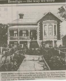
Newspaper - JENNY FOLEY COLLECTION: HEIDELBERG
Bendigo Advertiser ''The way we were'' from 2000. Heidelberg: located in Horace Street, Bendigo, the two-storey front of this house was added in 1885 to an earlier part of uncertain age. Basement rooms offered a cool summer temperature, but dampness was ever a problem. This house was built for Thomas Falkingham. The clip is in a folder.newspaper, bendigo advertiser, the way we were -
 Bendigo Historical Society Inc.
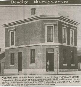
Newspaper - JENNY FOLEY COLLECTION: AGENCY
Bendigo Advertiser ''The way we were'' from 2000. Agency: Bank of New South Wales, corner of High and Victoria Streets, Eaglehawk. Construction of the building began in 1866 and it opened as an agency of the Sandhurst branch in 1867. It closed as a branch in 1919, after which it was used as a grocery store and residence. The clip is in a folder.newspaper, bendigo advertiser, the way we were -
 Bendigo Historical Society Inc.
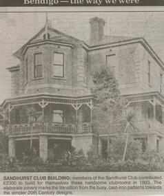
Newspaper - JENNY FOLEY COLLECTION: SANDHURST CLUB
Bendigo Advertiser ''The way we were'' from 2000. Sandhurst club building: members of the Sandhurst Club contributed 2,300 pounds to build for themselves these handsome clubrooms in 1893. The elaborate joinery marks the transition from the busy, cast-iron patterns towards the simpler 20th century designs. The clip is in a folder.newspaper, bendigo advertiser, the way we were -
 Bendigo Historical Society Inc.
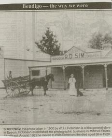
Newspaper - JENNY FOLEY COLLECTION: SHOPPING
Bendigo Advertiser ''The way we were'' from 2000. Shopping: this photo taken in 1900 by W.H. Robinson is of the general store in Epsom. Robinson established his photographic business in Mitchell Street, Sandhurst. Around 1901 he moved to Wills Street and he died aged 58 in 1920. The clip is in a folder.newspaper, bendigo advertiser, the way we were -
 Bendigo Historical Society Inc.
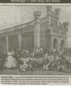
Newspaper - JENNY FOLEY COLLECTION: EDUCATING
Bendigo Advertiser ''The way we were'' from 2000. Educating: a picture of Kangaroo Flat Common School showing how the architects Vahland and Getzschmann meant it to look. It is Believed this picture was taken in 1870, the year the school was built. Later it became a special school and is now an annexe of the primary school. The clip is in a folder.newspaper, bendigo advertiser, the way we were -
 Bendigo Historical Society Inc.
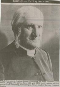
Newspaper - JENNY FOLEY COLLECTION: HOLY
Bendigo Advertiser ''The way we were'' from 2000. Holy: the second Anglican Bishop of Bendigo, the Right Reverend John Douse Langley, who served from 1907-until 1920. John Langley was the brother of the first bishop, Henry Langley. Picture courtesy Bendigo Historical Society. The clip is in a folder.newspaper, bendigo advertiser, the way we were -
 Bendigo Historical Society Inc.
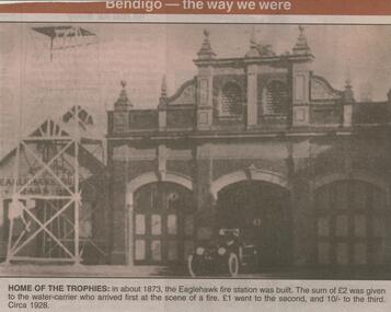
Newspaper - JENNY FOLEY COLLECTION: HOME OF THE TROPHIES
Bendigo Advertiser ''The way we were'' from 2001. Home of the trophies: in about 1873, the Eaglehawk fire station was built. The sum of 2 pounds was given to the water-carrier who arrived first at the scene of a fire. 1 pound went to the second and 10/- to the third. Photo circa 1928. The clip is in a folder.newspaper, bendigo advertiser, the way we were -
 Bendigo Historical Society Inc.
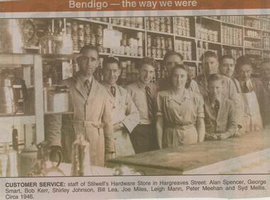
Newspaper - JENNY FOLEY COLLECTION: CUSTOMER SERVICE
Bendigo Advertiser ''The way we were'' from 2001. Customer service: staff of Stilwell's Hardware store in Hargreaves Street: Alan Spencer, George Smart, Bob Kerr, Shirley Johnson, Bill Lea, Joe Miles, Leigh Mann, Peter Meehan and Syd Mellis. Circa 1946. The clip is in a folder.newspaper, bendigo advertiser, the way we were -
 Bendigo Historical Society Inc.
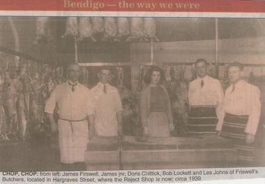
Newspaper - JENNY FOLEY COLLECTION: CHOP CHOP
Bendigo Advertiser ''The way we were'' from Monday, June 11, 2001. Chop,chop: from left: James Firsweel, James Jnr, Doris Chittick, Bob Lockett and Les Johns of Friswell's Butchers, located in Hargreaves Street, where the Reject shop is now, circa 1939. The clip is in a folder.newspaper, bendigo advertiser, the way we were -
 Bendigo Historical Society Inc.
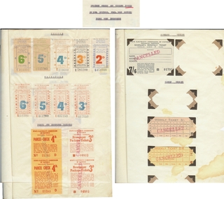
Document - BASIL MILLER COLLECTION: TRAMS TICKETS
Three sheets of paper stapled together showing specimen checks and tickets issued on 15th September 1949, when revised fares were introduced. A has 14 examples, b, and c, have 17 examples each. All have been issued by State Electricity Commission of Victoria, Provincial Tramways.person, individual, basil miller -
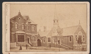 Bendigo Historical Society Inc.
Photograph - WES HARRY COLLECTION: ALL SAINTS SUNDAY SCHOOL
Two sepia toned photographs depicting the All Saints Church and Sunday school. (a) All Saints Manse and Sunday school, McKenzie Street Sandhurst., (b) Unknown church, possibly Cathedral, High St. Bendigo before spires were completed ?. The name ' Mrs. Robshaw ' is written on the back of both photos.M. Bent Centre of Pall Mall, Sandhurstbuildings, church, all saints., all saints church, sunday school, m. bent, mrs. robshaw -
 Bendigo Historical Society Inc.
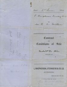
Document - CONNELLY, TATCHELL, DUNLOP COLLECTION: CONTRACT
Printed Contract and Conditions of Sale of Land, & c., dated 2 June 1898. Contract is for the sale of a property sold to Mr. Bartholomew A Walllace of Macorna. Contract sets out the payment schedule. Agents were L. Macpherson, Sternberg & Co. Ltd. Orange Victoria One Penny Duty Stamp attached.business, legal, connelly & tatchell, connelly & tatchell collection - contract, l macpherson sternberg & co ltd, bartholomew a wallace, j b young -
Port Melbourne Historical & Preservation Society
Document - Property valuation working papers, Australian Motor Industries, Bertie Street, Port Melbourne, George Levey, 1950 - 1974
Sample of working papers relating to the valuation of 29 premises in Port Melbourne. These papers were maintained by Mr George LEVEY, who was the City Valuer for PMCC from around the mid 1950s to about 1974. Details are all in manilla folders. .01 Australian Motor industries (AMI) . 155 Bertie Streetbuilt environment - commercial, business and traders, industry, australian motor industries, ami, george levey -
Port Melbourne Historical & Preservation Society
Document - Property valuation working papers, J E Earl, Bay Street, Port Melbourne, George Levey, 1950 - 1974
Sample of working papers relating to the valuation of 29 premises in Port Melbourne. These papers were maintained by Mr George LEVEY, who was the City Valuer for PMCC from around the mid 1950s to about 1974. Details are all in manilla folders. .05 - J E Earl. 181-189 Bay Streetbuilt environment - commercial, business and traders, local government - city of port melbourne, industry, george levey, j e earl pty ltd -
Port Melbourne Historical & Preservation Society
Document - Property valuation working papers, Fox Hay & Co, Beach Street, Port Melbourne, George Levey, 1950 - 1974
Sample of working papers relating to the valuation of 29 premises in Port Melbourne. These papers were maintained by Mr George LEVEY, who was the City Valuer for PMCC from around the mid 1950s to about 1974. Details are all in manilla folders. .07 - Fox Hay & Co. 42-54 Beach Streetbuilt environment - commercial, business and traders, local government - city of port melbourne, industry, george levey, fox hay timber and hardware pty ltd -
Port Melbourne Historical & Preservation Society
Document - Property valuation working papers, Gas & Fuel Corporation, Liardet Street, Port Melbourne, George Levey, 1950 - 1974
Sample of working papers relating to the valuation of 29 premises in Port Melbourne. These papers were maintained by Mr George LEVEY, who was the City Valuer for PMCC from around the mid 1950s to about 1974. Details are all in manilla folders. .08 - Gas & Fuel Corporation (GFC). 1 Liardet Streetbuilt environment - commercial, business and traders, local government - city of port melbourne, industry, george levey, gas & fuel corporation -
Port Melbourne Historical & Preservation Society
Document - Property valuation working papers, General Motors Holden, Salmon Street, Port Melbourne, George Levey, 1950 - 1974
Sample of working papers relating to the valuation of 29 premises in Port Melbourne. These papers were maintained by Mr George LEVEY, who was the City Valuer for PMCC from around the mid 1950s to about 1974. Details are all in manilla folders. .09 - General Motors Holden (GMH). 241 Salmon Streetbuilt environment - commercial, business and traders, local government - city of port melbourne, industry, george levey, general motors-holden, gmh -
Port Melbourne Historical & Preservation Society
Document - Property valuation working papers, Knox Schlapp Pty Ltd, Graham Street, Port Melbourne, George Levey, 1950 - 1974
Sample of working papers relating to the valuation of 29 premises in Port Melbourne. These papers were maintained by Mr George LEVEY, who was the City Valuer for PMCC from around the mid 1950s to about 1974. Details are all in manilla folders. .11 - Knox Schlapp Pty Ltd. 49 Graham Streetbuilt environment - commercial, business and traders, local government - city of port melbourne, industry, george levey, knox schlapp pty ltd -
Port Melbourne Historical & Preservation Society
Document - Property valuation working papers, A H Richards Pty Ltd, Kyme Place, Port Melbourne, George Levey, 1950 - 1974
Sample of working papers relating to the valuation of 29 premises in Port Melbourne. These papers were maintained by Mr George LEVEY, who was the City Valuer for PMCC from around the mid 1950s to about 1974. Details are all in manilla folders. .18 - A H Richards Pty Ltd. 3 Kyme Placebuilt environment - commercial, business and traders, industry, george levey, a h richards pty ltd