Showing 173449 items matching "melbourne."
-
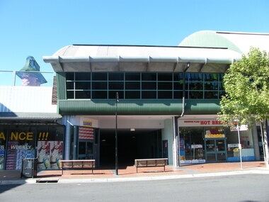 Ringwood and District Historical Society
Photograph, Below Melbourne Street to entrance of Eastland, Ringwood in 2008, showing shops at Ringwood Plaza
Photographic record by Russ Haines, RDHS, in 2008. -
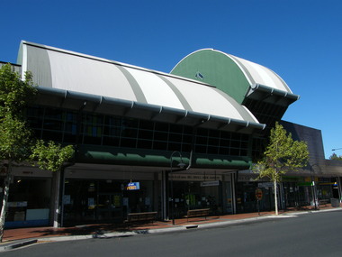
 Ringwood and District Historical Society
Photograph, Below Melbourne Street to entrance of Eastland, Ringwood in 2008, showing shops at Ringwood Plaza
Photographic record by Russ Haines, RDHS, in 2008. -
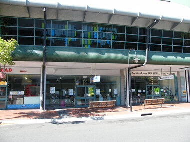
 Ringwood and District Historical Society
Photograph, Below Melbourne Street to entrance of Eastland, Ringwood in 2008, showing shops at Ringwood Plaza
Photographic record by Russ Haines, RDHS, in 2008. -
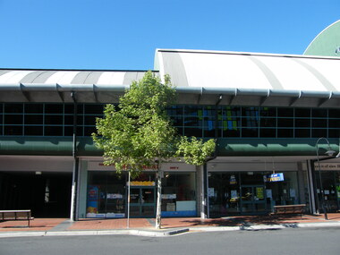
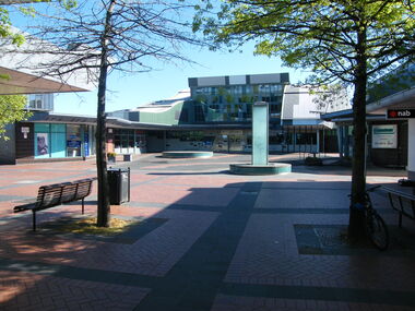
 Ringwood and District Historical Society
Photograph, Below Melbourne Street to entrance of Eastland, Ringwood in 2008, showing shops at Ringwood Plaza and Ringwood Library above
Photographic record by Russ Haines, RDHS, in 2008. -
 Ringwood and District Historical Society
Photograph, Entrance to Melbourne Street, Ringwood
Photographic record by Russ Haines, RDHS, in October 2008. -
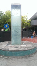 Ringwood and District Historical Society
Photograph, Water feature in Melbourne Street, Ringwood. Contruction work beginning at the Ringwood Railway Station and Stage 5 of Eastland circa 2014
Photographs taken by Terry Ahern in 2008-2014, member of RDHS -
 Ringwood and District Historical Society
Photograph, Former shops to the east of Melbourne Street in January 2008. Knocked down in later preparation for construction work beginning at the Ringwood Railway Station and Stage 5 of Eastland circa 2014
Photographs taken by Terry Ahern in 2008-2014, member of RDHS -
 Mission to Seafarers Victoria
Flyer, The Victoria Missions to Seamen (being the Victorian Seamen's Mission and the Melbourne to Seamen amalgamated), c. 1920
Charity organisation, Ladies' Harbour Lights Guild,was formed within The Missions to Seamen Institute to provide a home away from home, for visiting seamen. The flyer invited seafarers to use the institutes for 'Reading, Smoking and Writing and Special Events such as 'Sacred Song Service' and Concerts. This paper flyer holds historical significance at a local level because it illustrates the events and services that seafarers were invited to use and attend organized by the Mission to Seafarers.The Ladies' Harbour Lights Guild grew to become a significant charity in Melbourne raising large amounts of money which helped to establish the current MTS building, supporting seafarers as well as attending social events such as the ones promoted in the flyer. Paper Flyer in blue ink inviting seafarers to use the institutes for 'Reading, Smoking and Writing ;. Also invites them to Special events including dates venues for Socials, 'Sacred Song Services' and Concerts. Written in Black ink on the back: "The crues of the Cashelot" (?)missions to seamen institute, williamstown, port melbourne, special events, ladies' harbour lights guild, australian-wharf, lhlg, flinders street, seafarers, seamen, sailors, reading, smoking, writing, religious services, mission to seamen, seamen's institute, mission to seafarers -
 Mission to Seafarers Victoria
Book (item) - Visitor log book, Melbourne Visitors logbook, 2007
This book records the date, name, ship, nationality and signature of seafarers who visited the mission.A picture of where ships came from and the nationalities of their crews is presented. Front cover: MTS Visitors Book 10/08/07 to 22/02/08visitors, crew, ship, nationality, seamen, sailors, seafarers, melbourne, flinders street, mission to seafarers, seamen mission -
 Mission to Seafarers Victoria
Book (item) - Visitor log book, Marbig, Melbourne Visitors logbook, 2009
This book records the date, name, ship, nationality and signature of seafarers who visited the mission. A picture of the changing nature of the crews of ships visiting Melbourne is created.Noneship, visitor, nationality, name, seamen, sailors, seafarers, mission to seafarers, seamen mission, flinders street, melbourne, crew -
Ringwood and District Historical Society
Scrap Book, Scrap book containing clippings from local and Melbourne newspapers relating to various Ringwood topics circa 1917 to 1961, 1917 - 1961
Given to the Ringwood Historical Group by a collector of local history, but origins unknown. Many local names and events.Scrap book. Hard red cover with gold lettering, and half filled with cuttings from newspapers. Several loose cuttings. Cuttings are pasted on to cream coloured pages.Invicta Scrap Book -
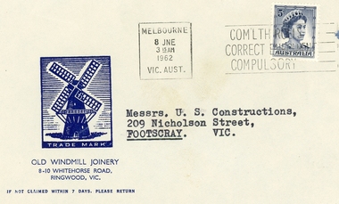 Ringwood and District Historical Society
Memorabilia - Postage envelope, Envelope pre-printed with Old Windmill Joinery (Ringwood) logo, and 5d postage stamp Cancelled Melbourne, 1962, 8-Jun-62
Buff coloured envelope (used) addressed to Messrs U. S. Constructions, Nicholson St. Footscray Vic. Picture of windmill as trademark. Sent from Old Windmill Joinery, 8-10 Whitehorse Road, Ringwood, Vic. -
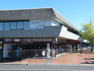 Ringwood and District Historical Society
Photograph - Multiple, Corner of 147 Maroondah Highway and Melbourne Street, Ringwood in 2008. Formerly the Commonwealth Bank, Burdines, Janome, Activate Church and Electoral Office. Buildings bought by QIC in 2000, 2008
Before Stage 5 of the expansion of Eastland and REALM.Digital photographs only -
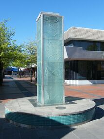 Ringwood and District Historical Society
Photograph - Multiple, Maroondah City Council water fountain located in Melbourne Street, Ringwood in 2008. Opened on 13 March 1997, 2008
Before Stage 5 of the expansion of Eastland and REALM.Digital photographs only -
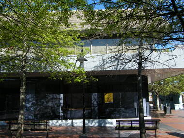
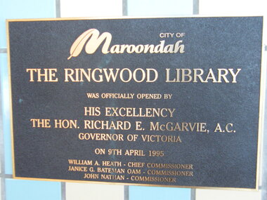 Ringwood and District Historical Society
Photograph - Multiple, Ringwood Library located in Melbourne Street, Ringwood in 2008. Opened on 8 April 1995 by His Excellency The Hon. Richard E. McGarvie A.C, 2008
Before Stage 5 of the expansion of Eastland and REALM.Digital photographs only -
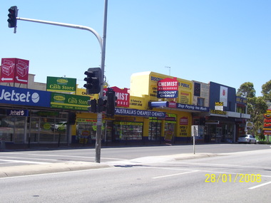
 Ringwood and District Historical Society
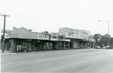
Photograph - Multiple, Melbourne Street, Ringwood in 2008, 2008
Before Stage 5 of the expansion of Eastland and REALM.Digital photographs only -
 Ringwood and District Historical Society
Photograph - Multiple, Shops in Melbourne Street, Ringwood in 2008, 2008
Before Stage 5 of the expansion of Eastland and REALM.Digital photographs only -
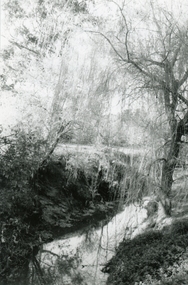
 Ringwood and District Historical Society
Photograph, Mullum Mullum Creek off Miles Avenue, view towards Warrandyte Road about where Melbourne St was on 10th September 1989, 1989
Digital photograph -
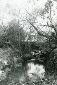
 Ringwood and District Historical Society
Photograph, Mullum Mullum Creek towards Ringwood Street, near old Melbourne Street off Miles Avenue, on 10th September 1989, 1989
Digital photograph -
 Ringwood and District Historical Society
Photograph, North side of Maroondah Highway, Ringwood Shops east of Melbourne Street on 26th January, 1991
Digital photograph -
 Kiewa Valley Historical Society
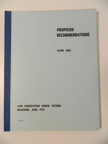
Report - Alpine Area Proposed Recommendations, Land Conservation Council, Victoria Melbourne, April 1978, April 1978
The Land Conservation Council was established by the Land Conservation Act 1970. It makes recommendations to the Minister for Conservation with respect to the use of public land. Notices showing the boundary of the study area ... published in the Victorian Government Gazette Sept. 1973. A descriptive report was published in July 1977. Submissions (1538) on the future use of public land were received & included those representing a wide cross-section of the community. These were considered in the final report.Of interest for research on the changing ideas regarding the use of public land and the environment.Blue book bound by dark blue cloth tape. It has 92 pages with maps at the end and an empty folder inside the back cover.alpine area, land conservation council, alpine study area report -
 Kiewa Valley Historical Society
Folder - Jessie Seymour, The London to Melbourne Great Centenary Air Race
Jessie Seymour was a resident of the Kiewa Valley.Jessie Seymour compiled this history for the Kiewa Valley Historical Society.Dark blue plastic with clear front cover and faint writing on the first page showing. 5 clear plastic sleeves / pages. Includes the description of the Air Race.jessie seymour; air race -
![Book - Map, Land Conservation Council, Melbourne Study Area Report, [December 1973]](/media/collectors/4f729f7b97f83e03086018a5/items/6469bc241d76dd4b008a829f/item-media/646b0013d841f8920fa4323c/item-fit-380x285.jpg) Eltham District Historical Society Inc
Eltham District Historical Society IncBook - Map, Land Conservation Council, Melbourne Study Area Report, [December 1973]
The Melbourne Study Report is a series of volumes describing the physical nature of the land and its environment, examines the likely forms of land use, and assesses the hazards associated with these uses. This is Volume 2 (coloured maps). The first page featues a black and white map described as "Shire of Diamond Valley" with public land marked in yellow. Followed by eight large fold out maps. Melbourne Study Area Public land and descriptive blocks, Population description, Geology, Physiography, topography and rainfall, vegetation and water supply. The Land Conservation Act 1970 established the Land Conservation Council whose functions is to "carry out investigations and make recommendations to the Minister with respect to the use of public land in order to provide for the balanced use of land in Victoria. This report sets out to describe and assess the natural resources of the public lands in the Melbourne area and provides a factual basis on which members of the community may base submissions to the [Land Conservation] Council of Victoria.A collection of eight large fold out coloured maps published in a bound book formnon-fictionThe Melbourne Study Report is a series of volumes describing the physical nature of the land and its environment, examines the likely forms of land use, and assesses the hazards associated with these uses. This is Volume 2 (coloured maps). The first page featues a black and white map described as "Shire of Diamond Valley" with public land marked in yellow. Followed by eight large fold out maps. Melbourne Study Area Public land and descriptive blocks, Population description, Geology, Physiography, topography and rainfall, vegetation and water supply. The Land Conservation Act 1970 established the Land Conservation Council whose functions is to "carry out investigations and make recommendations to the Minister with respect to the use of public land in order to provide for the balanced use of land in Victoria. This report sets out to describe and assess the natural resources of the public lands in the Melbourne area and provides a factual basis on which members of the community may base submissions to the [Land Conservation] Council of Victoria. maps, shire of diamond valley, population, geology, topography, rainfall, vegetation, water supply, land use, public lands -
 Eltham District Historical Society Inc
Map (item) - Sales Brochure, Plenty Township Estate and Bryn Teg Hill's Estate, Coghill & Haughton, Melbourne, c.1924
Plenty Township Estate "The rapid growth of Greensborough and the great traffic development on the main road between Heidelberg and Eltham augurs well for Plenty Township Estate. Already a Store, Post Office and State School have been started, and the activities of the Local Progress Association will help the district forward considerably. Within walking distance of the Montmorency and Greensborough stations." Bryn Teg Hill's Estate "Better known as "The Old Sand Hill, "within walking distance of the Montmorency and Greensborough railways stations." "Some few years back Mrs Thomas subdivided portion of the Sand Hill Paddocks, and the areas sold have been settled and many converted into charming outer suburban garden homes with cultivation and orchard plots. The south-eastern slope gives the land a grand outlook over the Yarra Valley on to the Dandenoings, and the are is very picturesque and homely." "A number of the blocks contain large deposits of valuable building sand, which should prove good speculation in view of the forecast for further rapid home development along the Eltham Suburban Electric Service." Sand Hills Road (Old Eltham Road) Date estimated as c.1924 - Electricification of railway line to Eltham referenced on map occured April 1923 and Mrs Mary Thomas died August 1925. Her home Bryn Teg became part of the Heidelberg Golf Club in 1927.The establishment of Lower Plenty as a suburban growth area supported by easy commuting facilitated by the elctrification of the Eltham railway linebonds road, bridge, bryn teg hill's estate, coghill & haughton, eltham road, heidelberg golf club hotel, houses, lower plenty, lower plenty bridge, lower plenty road, main road, plenty hotel, plenty river, plenty township estate, real estate agent, sales brochure, sand hills road, the old sand hill, sand hill paddocks, woodfull road, old eltham road, bryn teg, mrs m thomas -
 Eltham District Historical Society Inc
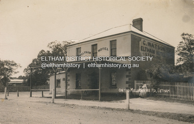
Photograph, Watson's Eltham Hotel on the Melbourne Road, Eltham, 1908
The Eltham Hotel was opened in 1854 situated on the south east corner of Main Road (Maria Street) and Pitt Street. Post card dated Eltham 2.1.1908 sent to Mr C. Watson "Malvale" Mardan Inscribed "Wishing you a Brigt and Happy New Year from Florrie" Most likley sent by Florence May Shillinglaw to sister Carrie Watson and new brother-in-law Christopher Watson - The Watsons married in 1907 View looking south on Main Road towards Pitt Street and Watson's Eltham Hotel on left. At this time, the hotel was run by Christopher Watson Jnr. Carrie Shillinglaw had recently married his son, Christopher. Ultimately the hotel would pass to his youngest son, Herbert James (Jim) Watson who demolished the original building in 1925 and erected a new modern building on the same site that remains in present time though modified several times over the years. See also EDHS_00133 POSTCARD 1905-1940s Like the carte-de-visite, postcards enjoyed a collecting craze by large numbers of people, and were often kept in albums through which the interested visitor could browse. Postcards were posted or exchanged in huge numbers. Postal authorities in Australia only allowed the private printing of postcards from 1898. At this time the back of the card was reserved for the address and postage stamp, and the front was used for the message and a picture. In 1902 British authorities allowed a "divided back", so that the left side could be used for the message, the right side for the address and stamp, and the whole of the front was devoted to the picture. France followed suit in 1904, Germany and Australia in 1905, and the United States in 1907. - Frost, Lenore; Dating Family Photos 1850-1920; Valiant Press Pty. Ltd., Berwick, Victoria 1991marg ball collection, postcard, eltham hotel, florence may bunker (nee shillinglaw) (1886-1969), main road, pitt street, caroline (carrie) watson (nee shillinglaw 1876-1956), christopher watson, 1908 -
 Eltham District Historical Society Inc
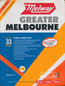
Book, Melway Publishing, Melway Greater Melbourne street directory : including Geelong, Phillip Island, Healesville, Kinglake, Gisborne, Lorne, Wallan, Bacchus Marsh Bellarine & Mornington Peninsulas; Edition 33, 2006, 2005
Edition 33. 2006 Coloured detailed maps accessed by a street or location index. Cover: Totally revised and updated with over 1380 new street listings new maps covering Mount Duneed on the Bellarine Peninsula, Pakenham South and Rythdale. Detailed public transport routes - train, tram, bus, bicycle paths & shared road routes. Eastlink fully detailed new Craigieburn bypass GPS compatible WGS/MGA Grid Special feature: New Hierachy of Roads Street directory with plastic cover, coloured maps, 902 pagesstreets,roads,melbourne,map,melway -
 Eltham District Historical Society Inc
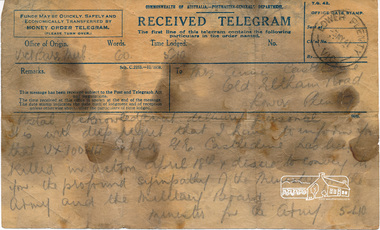
Telegram, Telegram, Victoria Barracks, Melbourne to Mrs Annie Castledine, Old Eltham Road, Lower Plenty, 3 May 1941, 3 May 1941
"Postal acknowledgement delivery personal" "It is with deep regret that I have to inform you that VX10044 Sapper G. E. Castledine has been killed in action April 18th & desire to convey to you the profound sympathy of the Minister for the Army and the Military Board. - Minister for the Army" Sapper George Ernest Castledine (1914-1941), son of Arthur Frederick and Annie Castledine, enlisted 23 January 1940 at Lower Plenty and was assigned to the 2/2 Field Company. He is buried in the Phaleron War Cemetery, Athens, Greece and is remembered on the Roll of Honour at Eltham.George was the first soldier from the Shire of Eltham to be killed in the Second World War. The telegram is oil stained as it was kept by George's brother Sid in his toolbox.Digital image of original held in private collection of Joan Castledine (niece of George Ernest Castledine and daughter of Sid and Polly (nee Arrowsmith) Castledine).Original bears oil stains from being stored in a tool box2/2 field company, aif, annie castledine, arthur frederick castledine, eltham war memorial, george ernest castledine, military, minister for the army, roll of honour, second word war, sid castledine, telegram -
 Eltham District Historical Society Inc
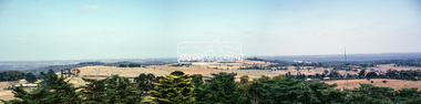
Slide - Photograph, View of Melbourne from Shire of Eltham War Memorial tower, Kangaroo Ground, c. 1988
35mm colour positive transparency (x3) Mount - Black and White Digital panorama stitched from three imageskangaroo ground, shire of eltham war memorial, war memorial tower -
 Eltham District Historical Society Inc
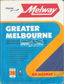
Book, Melway Greater Melbourne street directory : including Geelong, Phillip Island, Healesville, Bellarine & Mornington Peninsulas; Edition 26, 1999, 1999
Street directory with plastic cover, coloured maps, 772 pages 28 cm x 21.5 cm 1998streets, roads, melbourne, maps, melway -
 Eltham District Historical Society Inc
Postcard, Postcard to Lily Howard from Charlie Harris, Melbourne, 16 January 1916, 1916
Digital file only - scanned by EDHS from item on loan aif, charlie harris, first world war, letters, lew howard collection, ww1