Showing 4783 items matching " authority"
-
 Beechworth RSL Sub-Branch
Field Notebook Holder Contents, c2012
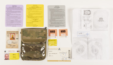
Contents belonged to Major Damien Batty whilst serving with the United Nations Forces in Afghanistan. Major Damien Batty served in Afghanistan in 2011-2012 with the Bravo Commando Company Group, 2nd Commando Regiment in Uruzgan. The Commandos took part in 20 rotations with the Special Operations Task Group (SOTG) between 2007 and 2012. During this time they undertook significant combat operations, and were awarded for its actions, the regiment was collectively awarded the Unit Citation for Gallantry and the Meritorious Unit Citation.Contents from the Field Notebook Holder, (see 0096.1) belonging to Major Damien Batty whilst serving with the United Nations in Afghanistan. Located in the clear plastic compartment of the Field Note Holder: 0096.02 - Authority card in colour featuring a photograph of Major Damien Batty. 0096.03 - Facility access card in colour featuring a photograph of Major Damien Batty. Located in the folded compartment of the Field Note Holder: 0096.04 - White boarding pass with colour text 0096.05 - Peach sticker with black text 0096.06 - Peach sticker with black text 0096.07 - Green sticker with black text 0096.08 - White A4 sized paper copy of passport with certification stamp 0096.09 - Small grey Rules of Engagement card with a gloss surface and rounded corners. Has text on both sides 0096.10 - Small yellow Rules of Engagement card with a gloss surface and rounded corners. Has text on both sides 0096.11 - Small purple Rules of Engagement card with a gloss surface and rounded corners. Has text on both sides 0096.12 - White piece of paper torn from a spinal notebook with written text in blue and red ink. (Not pictured) 0096.02 - UNESCORTED / WEAPONS AUTHORISED / CELL PHONE ALLOWED / BATTY / TF-66 / VALID UNTIL 5 DECEMBER 2012. 0096.03 - 03-MAR-74 / BATTY DAMIEN / OF-3 Back 0096.04 - ADAGOLD / AVIATION PTY LTD / FROM SYDNEY / TO MIHAD MILITARY / DATE 05 JUN /1310 / 0096.05 - NHD / 10987 /ADAGOLD / AVIATION PTY LTD / 0096.06 - NHD / 10986 / ADAGOLD / AVIATION PTY LTD / 0096.07 - QUALITY CONTROL / 0096.08 - DAMIEN BATTY / 0096.09 - RESTRICTED / DEPARTMENT OF DEFENSE / SEARCH AND DETENTION / OP SLIPPER / (AFGHANISTAN ONLY) / DEC 2010 / 0096.10 - RESTRICTED / DEPARTMENT OF DEFENSE / MEAO FORCE PROTECTION / INDIVIDUAL GUIDANCE ON THE USE OF FORCE / APR 2009 / 0096.11 - RESTRICTED / DEPARTMENT OF DEFENSE / PURPLE CARD / ORDERS FOR OPERATING FIRE / OP SLIPPER / contents, field notebook holder, identification, united nations -
 Melbourne Tram Museum
Photograph - Digital Image, Public Transport Victoria (PTV), "St Kilda Road and High Street - Buses replace trams - Sunday 13 Oct. to Sunday 27 Oct.", Oct. 2019
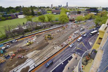
.1 - Pamphlet - 2 x 3 fold x titled "St Kilda Road and High Street - Buses replace trams - Sunday 13 Oct. to Sunday 27 Oct." 2019 for works at Domain, Park and St Kilda Road and track relay in High Street between St Kilda Road and Williams Road. Gives alternative bus routes. Part of the work was for the construction of the Noise Box or acoustic shed over the future Anzac Station site - part of the Metro Tunnel Works and track relocation. See htd3930i2.pdf for a detailed description of the work from the Metro Tunnel authority - Rail Projects Vic. This file does not want to open properly using dbtext works, access directly. Image i3 - from tdu website https://tdu.to/m/262235/re-d2-5005-at-temporary-tram-termin-us-st-kilda-road, shows the works underway. Posted by Metro Tunnel on twitter today showing progress on relocating tram tracks at site of Anzac station. This will allow construction of the southern box of the station. Large file (~2.6MB and 4096x2733 pixels, but enables you to get "up close and personal".trams, tramways, park st, domain junction, metro tunnel, toorak rd, st kilda rd, tramway construction -
 Bendigo Historical Society Inc.
Book - MINING REPORTS - THE CONFIDENCE GROUP OF MINES BULLETIN NO 41
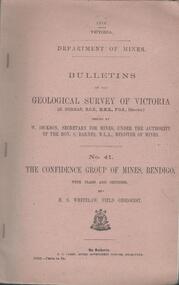
Light brown covered booklet 'Bulletins of the Geological Survey of Victoria issued by W Dickson, Secretary for Mines, Under the Authority of the Hon. S Barnes M L A Minister of Mines. No 41 The Confidence Group of Mines, Bendigo with Plans and Sections by H S Whitelaw, Field Geologist, dated 1918. Mines mentioned are: Confidence Extended Mine, Confidence Tribute Company and the Central Windmill Hill Mine. Mentioned in the report are crushings and gold yield, details of levels, names of leases along the reef. Extracts from Mine Manager's Half-yearly Reports, 1878-1915 of tons crushed and gold yield. Plans and sections of the Confidence Extended Mine on the Garden Gully Line of Reefs are: Plate I General Plan of All Levels, Plans of Levels Plate No II, Plans of Levels Plate No III, Transverse Section Plate No IV, Longitudinal Section Plate No V, and Central Windmill Hill Mine Transverse Section Plate No VI. Plates signed by H S Whitelaw 17 & 18/6/16 and 20/7/16. Booklet if part of the Albert Richardson Collection. book, bendigo, mining reports, mining reports, the confidence group of mines bulletin no 41, confidence extended mine, confidence tribute company, central windmill hill mine, department of mines, bulletins of the geological survey of victoria, w dickson, the hon s barnes, h s whitelaw, h j green, mr robert eddy, mr w h cundy, j foster, c j thompson -
 Eltham District Historical Society Inc
Document - Folder, Marshall, Neil Leslie
Neil Leslie Marshall, a Panton Hill resident, had various roles in the Country Fire Authority, from firefighter to Deputy Chair of the CFA Board. In 2023, he was awarded an Australian Fire Service Medal. He joined the Panton Hill Fire Brigade in 1960 and later was active in arranging support and welfare for brigade families affected by fire. Contents Newspaper article: "Plaudits for top citizens", Diamond Valley Leader, 5 February 2020, Names of Nillumbik Council's Australia Day awards: Neil Marshall, Carol Jenkinson, Tony Barbeta (photograph also includes Robert Marshall) Newspaper article: "Neil Marshall's service to CFA spans more than 61 years", Manningham and Nillumbik Bulletin, February 2023, Neil Marshall awarded Australian Fire Service Medal in 2023 Australia Day Honours for his contribution to the emergency services and communities of Victoria. Newspaper clippings, A4 photocopies, etcneil marshall, panton hill victoria, australian fire service medal, country fire authority, ash wednesday fire, north warrandyte victoria, brian potter, st andrews victoria, carol jenkinson, diamond valley college, hurstbridge wattle festival, tony barbeta, st andrews mens shed, nillumbik youth productions, robert marshall -
 City of Moorabbin Historical Society (Operating the Box Cottage Museum)
Document, photocopy of Plan of Beaumaris 1853, c1960
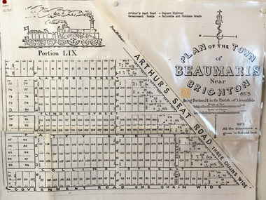
Beaumaris includes two early estates in the parish of Moorabbin developed by Josiah Holloway from 1852. Named Beaumaris Town and Beaumaris Estate (after the pastoral run in the area and ultimately after Beaumaris in Wales), the lots comprising them were marketed by Mr Holloway's suggesting that the railway was imminent and a canal would be built. The township developed slowly, a Post Office opened on 1 March 1868, but was replaced next month by Gipsy Village office (now Sandringham) In 1862 Beaumaris was one of the early settler communities within the boundaries of the Moorabbin District Roads Board , the region’s first local government authority. Beaumaris is a suburb in Melbourne, Victoria, Australia, 19 km south-east from Melbourne's central business district. .Since the Amalgamation of Councils 1994 the local government area is the City of Bayside which includes Brighton. A Photocopy of the Plan of Beaumaris 1853 A3moorabbin, county of bourke, brighton, beaumaris, pioneers, early settlers. market gardeners, cheltenham, king. john, holloway josiah, whorral charles, arthur’s seat road, nepean highway, morabbin district roads board, sandringham, mordialloc, mentone -
 Marysville & District Historical Society
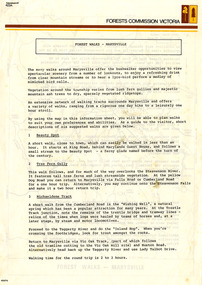
Flyer (Item) - Information Flyer, Forests Commission, Victoria, FOREST WALKS - MARYSVILLE, 1918-1983
An information flyer that was produced as a guide to the forest walks in and near Marysville by the Forests Commission of Victoria. The Forests Commission Victoria (FCV) was the main government authority responsible for management and protection of State forests in Victoria, Australia between 1918 and 1983. The Commission was responsible for ″forest policy, prevention and suppression of bushfires, issuing leases and licences, planting and thinning of forests, the development of plantations, reforestation, nurseries, forestry education, the development of commercial timber harvesting and marketing of produce, building and maintaining forest roads, provision of recreation facilities, protection of water, soils and wildlife, forest research and making recommendations on the acquisition or alienation of land for forest purposes″. An extensive network of walking tracks surrounds Marysville and they offer a variety of walks ranging in various levels of difficulty. This information flyer provides information such as the level of difficulty for six suggested walks around Marysville.An information flyer that was produced as a guide to the forest walks in and near Marysville by the Forests Commission of Victoria.marysville, victoria, australia, forest walks, forests commission victoria, beauty spot walk, tree fern gully walk, michaeldene track, keppel track, woods lookout track -
Unions Ballarat
Power, action and belief: A new sociology of knowledge?, 1986
Sociological text that explores social structure. Marxist and Durkeimian influences. Editor's introduction: Power/knowledge and the dissolution of the sociology of knowledge / John Law -- Art exhibitions and power during the nineteenth century / Gordon J. Fyfe -- The Politics of schism: routinisation and social control in the International Socialists/Socialist workers' party / Steve Rayner -- The Social preconditions of radical scepticism / Mary Douglas -- The values of quantification / Jean Lave -- 'Interests' in political analysis / Barry Hindess -- Interactive-orientation and argumentation in scientific texts / Steven Yearley -- The Question of ideology: Althusser, Pecheux and Foucault / Mark Cousins and Athar Hussain -- On authority and its relationship to power / Barry Barnes -- Some elements of a sociology of translation: domestication of the scallops and the fishermen of St Brieuc Bay / Michel Callon -- On the methods of long-distance control: vessels, navigation and the Portuguese route to India / John Law -- The Powers of association / Bruno Latour. Socially and politically significant. Broad relevance to how societies work.Paperback; white background; blue and black text; price sticker; 280 pages.Back cover: contributors' and editor's bios. Front cover: editor's name and title.btlc, ballarat trades and labour council, ballarat trades hall, power, knowledge, art, socialism, sociology, politics, science, ideology -
 Ballarat Heritage Services
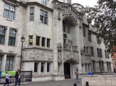
Digital photograph, Exterior, Supreme Court, London, 2016, 19/09/2016
1 October 2009 marks a defining moment in the constitutional history of the United Kingdom: transferring judicial authority away from the House of Lords, and creating a Supreme Court for the United Kingdom in the historic setting of the former Middlesex Guildhall on Parliament Square. In this location, The Supreme Court forms part of a pre-existing quadrangle made up of the Houses of Parliament, Westminster Abbey and Treasury. As civil administration developed, it tended to be conducted by the Justices of the Peace and its offices were often co-located with the first tier of the courts. This close association reached a peak in the latter half of the nineteenth century, since when the two activities have tended to separate. In April 2005, all Magistrates’ Court houses were transferred from the care of County Councils to the Department of Constitutional Affairs (DCA). (https://www.supremecourt.uk/about/history.html, accessed 21 September 2016)london, supreme court, law, legal -
 Melton City Libraries
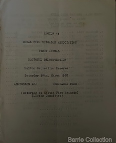
Booklet, Region 14 Rural Fire Brigades Association, 1968
Formation of the Mt Cottrell Fire Brigades Group In its policy of creating smaller compact groups of fire brigades the Country Fire Authority Regional Officer Harry Rothsay in 1967 requested that the following 6 brigades surrounding Mt Cottrell transfer from their respective groups. Melton and Rockbank from Bacchus Marsh Group, Toolern Vale and Sydenham from Mt Macedon Group and Truganina and Werribee from Little River Group forming a new Group to the be named Mt Cottrell Fire Brigades Group. Group Headquarters was established at the Ferris road residence of Melton Captain E W Bon Barrie, who was elected Group and Communications Officer of Mt Cottrell. E W (Eddie) Gillespie and Keith Watt of the Toolern Vale brigade were appointed Deputy Group Officer and Group Secretary respectivelyRegion 14 Rural Fire Brigades Association First Annual Demonstration programmeemergency services -
 Wodonga & District Historical Society Inc
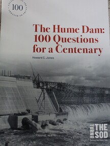
Book - The Hume Dam: 100 Questions for a Centenary, Howard C Jones, 2019
A booklet describing the history of the Hume Dam in question-and-answer format, illustrated by photographs from the Albury City Collection and other sources. This booklet was produced to accompany the exhibition "Turning the sod: building the Hume Dam", on display at Lavington Library from 21 December 2019 -1 March 2020."non-fictionA booklet describing the history of the Hume Dam in question-and-answer format, illustrated by photographs from the Albury City Collection and other sources. This booklet was produced to accompany the exhibition "Turning the sod: building the Hume Dam", on display at Lavington Library from 21 December 2019 -1 March 2020." hume dam, dams -- new south wales, hume dam history, dams -- new south wales -- design and construction -
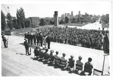 Melbourne Legacy
Photograph, Legacy 50th Anniversary, 1973
Photos of a service at the Shrine in 1973. People in the crowd have name badges from around Australia so it is likely this service was held during the Legacy Conference held in Melbourne in 1973. President Geoff Handbury is among the official party. In the second photo Legatee Kem Kemsley is seen at the microphone, behind him are, from left, L/- Rex Hall, L/- George Cowan, President Geoff Handbury and Sir Edmund Herring, Lieutenant-General of Victoria. In the crowd legible name tags include; Milton Whiting from Mildura and Molly Tonkin from Sydney. Photos came from an envelope marked P1 Federal Conference 1973 / 50 Year anniversary / 1983 Morewell / 1973 Legacy March ANZAC Day, 50 yr celebration, inclusion in ANZAC Day March authority of RSL". See items 00451 to 00455, 00460 to 00464, 00391. A record of a gathering at the Shrine to mark the 50th anniversary of Legacy during the Golden Jubilee year 1973.Black and white photo x 8 of a service at the Shrine for the 50th Anniversary Legacy in 1973.All stamped "This Photograph is with the compliments of the Ministry of Tourism, Government of Victoria. Please acknowledge Michael Cheshire" in grey ink.golden jubilee, conference -
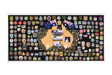 Department of Energy, Environment and Climate Action
Display board
The Forests Commission and its successors continuously encouraged bushfire research and innovation. In 1946 a large parcel of industrial land was purchased at North Altona as a fire cache and workshop. The Altona workshop became a hotbed of new technological innovation… an exhilarating place where lots of things were invented and tested. In fact, a lot of Australia’s pioneering equipment development was led by staff from Altona, often in collaboration with other State forestry and fire authorities. The CSIRO also contributed significantly. The US Forest Service, the US Bureau of Land Management and US State agencies such as the California Department of Forestry and Fire (CalFire) as well as the Canadian Forest Service faced similar challenges and proved strong and willing partners in sharing knowledge, ideas, equipment and expertise over many decades. This collection of badges is testament to the relationships that were forged across the globe with the Altona workshop. Large display panel featuring many fire service badgesforests commission victoria (fcv), bushfire, bushfire aviation -
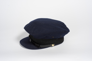 City of Greater Bendigo - Civic Collection
Uniform - Department of Supply Cap, 1971
Established in 1950, the Department of Supply headquarters transferred to Canberra in January 1968 and was dissolved in 1974. It was superseded by the Department of Manufacturing Industry and Department of the Special Minister of State. The Department was a Commonwealth Public Service department, staffed by officials who were responsible to the Minister for Supply. The department's main function was to support Australia's Navy, Army and Air Force in defence production, research and development, purchasing, transport and storage. The Department was also the Commonwealth Disposals Authority. Finally, the Department was responsible for the Australian Antarctic program. Bendigo was the site of an Ordnance Factory and manufactured and reconditioned naval guns and mountings, turbine gears for large ships, general heavy engineering work, large fabricated structure and missile handling equipment. The factory was managed in 1970 by R.I.M Moss. The department may have had an office in the former Bendigo Post Office now the Bendigo Visitor Information Centre.Blue, felt or wool peaked service cap with woven band and plastic strap. Small brass buttons. The cap has a synthetic lining around the crown and on the roof of the cap. Marked on the inside with the maker's details.bendigo post office, city of greater bendigo uniform -
Ballarat Tramway Museum
Document, Hector Bell Junior, "Street passenger transport system of Geelong Urban Area", 1949
Report by Hector H Bell Junior of the MMTB early 1949, titled "Street passenger transport system of Geelong Urban Area". Looks at the history of public transport in Geelong, tramway data, financial analysis, the Geelong bus system, buses servicing the North Shore industries - principally the Ford Works, the condition of the bus fleet, taxi and private car hire services, functions of a street transport authority, town planning, populations and traffic surveys, relative values of passenger vehicles, trolley buses, industry and recommendations. Said the tramway system was obsolete, should be a rail service between North and South Geelong, set up a street transport body, replan the Geelong railway station, additional roads to service the North Shore area. Refers to attachments. Has a list of people involved in the preparation of the report. See item 112 for the AETA response of April 1949 to this report.Yields information about the Geelong tram and bus services in 1948/49 and how it could be developed or reformed. Has a close association with Hector Bell Junior, the son of the then MMTB Chairman.Document - 18 foolscap sheets photocopied and stapled in three places along the side.tramways, secv, geelong, statistics, history, passenger services, reports, aeta -
 Federation University Historical Collection
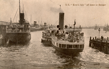
Postcard, S.S. "Erin's Isle" off down to Bangor, 1912
Erin's Isle was a paddle steamer built in 1912 by Messrs. A. & J. Inglis Pointhouse, Glasgow, for the Belfast and County Down Railway Company. It provided a regular service between Belfast Lough and Bangor, County Down in the summer season. In November 1915 it was requisitioned by the Admiralty, initially for transport purposes, and later as an auxiliary mine sweeper. Surviving World War One, this vessel as lost on 7 February 1919 after hitting a stray mine at the entrance of the Thames Estuary and immediately sank. There were 23 lives lost, and 28 survivors. Bangor is a city in Gwynedd Unitary Authority, north west Wales, and one of the smallest cities in Britain. This postcard was sent home to Australia by a six bob a day tourist, and member of the Australian AIF on active service. During leave soldiers often visited tourists sites, family, or towns important to their ancestral heritage.A view of paddle steamer with three moored mail steamers are visible to the left, and a pier and lamp on right. A ship can be seen iin distance on right. S.S Erin's Isle off down to Bangorchatham-holmes family collection, bangor, belfast, mail ships, steam ship, six bob a day tourist -
 Bendigo Historical Society Inc.
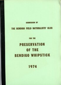
Document - PETER ELLIS COLLECTION: SUBMISSION BY THE BENDIGO FIELD NATURALIST CLUB FOR THE PRESERVATION OF THE WHIPSTICK 1974, 1974
PETER ELLIS COLLECTION: SUBMISSION BY THE BENDIGO FIELD NATURALIST CLUB FOR THE PRESERVATION OF THE WHIPSTICK 1974 The submission was sent to: the Minister for Local Government and the Town and Country Planning Board The Minisry for Conservation and its agency, the Forests Commission and Lands Department Federal Government Ministeries for Environment, Concervastion and Science, and the National Estate. Opening Paragraphs: This re-submission was compiled to bring to the attention of the authorities many aspects relating to the preservation of the Bendigo Whipstick which were not so apparent at the time of the earlier submission. In fact the 19721 submissions was mainly aimed at having reserved forest (which lie a opposite extremities to the Whipstick scrub) declared Forest Park. It is the central belt of Whipstick scrub that is of scientific interest and considered unipue and which we were primarily concerned in preserving and retaining as one viable ecological unit. The Submission consists of: INTRODUCTION Opening Explanation Whipstick Eucalyptus Cutting for Oil Distallation (Photographs) Agricultural Intrusions into the Whipstick (Photographs) CONTENTS Illustrations The Significance of the Bendigo Whipstick Diary of Whipstick Conservation Events Socialogical Implications Conservation policies and reccomendations Agricultural Aspects Eucalyptus Oil Situation Alternatives for the Eucalyptus Oil Industry Future Conservation of the Whipstick Reccomendation for Acquisition Programperson, individual, peter ellis oam -
Moorabbin Air Museum
Document (item) - Roger Alder Collection See Description for list of items
-
 Ballarat Tramway Museum
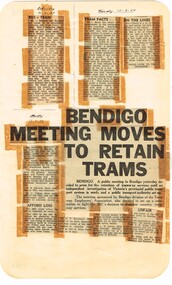
Newspaper, State Electricity Commission of Victoria (SEC) and The Courier Ballarat, Bendigo Meeting to moves to retain trams, Feb. 1962
Yields information about the views of various letter writers, Bendigo union views, Geelong, public meetings, finances and protest action.Foolscap sheet of plain paper, with rounded corners, with 4 newspaper cuttings, concerning the mooted closure of the Ballarat Tram system 10 Feb to 13 Feb 1962. All from The Courier, unless noted otherwise. 1 - "Bus v Tram" - 10-2-1962 - letter - from M Stewart of Sydney, say that the move to buses as in Sydney should not be allowed to happen. 2 - "Tram Facts" - 13-2-62 - letter - about the need for a private operator to run at a profit, higher fares - a public authority would maintain concession fares. 3 - "On the Lines" - 13-2-62 - letter - supporting the trammies. 4 - "Bendigo Meeting Moves to Retain Trams" - 12-3-62 - reporting on a meeting of 11-2-62- in Bendigo, well attended. Included the local Union Secretary, Mr G. T. James, State Secretary Mr C O'Shea, President Mr. S. Edwards, note that fares in Geelong had increased 100% since closure there. Mr Stoneham, noted that the petition to close the system must be laid in Parliament for 24 days. The current sitting would not last that long and it won't be considered until the Spring session.closure, atmoea, unions, parliament, bendigo, geelong, sec -
 Kiewa Valley Historical Society
Ron White's Collection - 1920 - 2019
Ron White was born in 1920. He received a Diploma of Mechanical Engineering at Footscray Technical School in 1946. He started work as a laboratory assistant and after several promotions was appointed Senior Operator in 1948. In 1949, he was Engineer, Grade 1 (Hydro Areas). After further promotions he became Assistant Area Engineer, Rubicon at new Eildon Power Station and Area Engineer, Kiewa in commissioning Mt Beauty Terminal Station and West Kiewa Power Station.. By 1956, he was the Area Operations Engineer at Kiewa and four years later the Kiewa Electrical Superintendent (Operations and Maintenance) . In 1961, he was officially recognised as deputy for the General Superintendent, Kiewa. In 1966 he was appointed General Superintendent Kiewa and Kiewa became 'a branch of the Transmission Department'. In 1974, the Rubicon / Eildon Area was also under Ron's control. His title was "Principal Hydro Engineer, Hydro Division, Transmission Operations Department. He held this position until his retirement in 1985.Ron White was an important identity in his role as Principal Hydro Engineer from 1966 to 1985 after the completion of the Kiewa Hydro Electric Scheme. His long period of service involved him in the construction, operation and maintenance of the SECV's Hydro Electric Schemes and administration of related catchment areas. He had a close association with the local communities and care for the welfare of employees. He lived in Mt Beauty and was well respected in the community and beyond. He passed away on 30 September 2019, aged 99 years.A) History of Ron White's Working Life: including papers relating to "Promotion & Staff Appointment" B) Ron White's Retirement - 11th Jan. 1985: papers, cards, letters, photos, disc/plaque C) Ron White's Certificates: Diploma of Mechanical Engineering; First Aid; D) Ron White's Correspondence - miscellaneous E) Ron White's History of the 'Kiewa Scheme' from 1936- 1966. Written 1986 F) Ron White's Photo album Includes photos of him and the 2003 bushfires G) Miscellaneous Photos (not labelled) from Ron's photo album. Possibly relatives including nieces and nephews. H) Pewter Mug presented to Ron - Water Board I) Wall hanging presented to Ron - Scouts J) Ron White's Slide Ruler & Mathematical Instruments K) Collection of 7 books owned by Ron L) Starting Pistol Caps box M) Ice-cream serverF) One photo of Ron with 'Ken Connors'. One photo with 'l to r: Norm Middleton, Graham Napier, Ron White, Les Peart.' G) 2003 fires has a note re time, date and whereabouts of fires H) "Presented To / Ron White / In Appreciation For Service / To The / Kiewa Valley / Water Authority / And / Its predecessor Bodies / December 1994 I) Wall hanging: On emblem - "Lord Baden-Powell Society / The Scout Association of Australia". On Name Plate below - Ronald K. White 1989" J) mathematical Instruments have 'R. W' embossed in red on the corner of the cover M) 100 Straitline, Starting Pistol Caps N) National Ice-cream Server with stainless steel spring Size 20 ron white, hydro engineer, kiewa hydro electric scheme -
 Eltham District Historical Society Inc
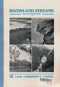
Book, Land Conservation Council, Rivers and Streams: Special Investigation, September 1989
In June 1987, the government directed the LCC to carry out a special investigation of the social, recreational, cultural and ecological values of rivers and streams in Victoria, and to make recommendations on the use of these rivers and how their identified values can best be protected. Notices announcing the commencement of the investigation were published in the Victoria Government Gazette and in Victorian newspapers in November 1987. A descriptive report was published in September 1989. The Council received 75 submissions following the publication of this report. After considering these submissions, the Council formulated its proposed recommendations, which were published in November 1990. The Council received 177 submissions commenting on the proposed recommendations. The Council published its final recommendations in June 1991. While welcomed by many, the study cut across the interests of other groups and was perceived to be particularly threatening to water authorities. The investigation resulted in a legislated system of 17 heritage rivers (with significant natural, recreational, scenic and heritage values) and natural catchment areas across Victoria. -
 Orbost & District Historical Society
plan, before 1948
Drainage infrastructure was developed and maintained in this region by the Snowy River Improvement Trust. The Trust was administered by a local committee and its activities funded by a local rate charged on the farmers and land owners in the Trust’s designated district. The level of the rate charged by the Trust was designed to be proportionate to the benefit derived from the works undertaken. Financial assistance was provided by the State Government from time to time for specific projects such as post flood repairs but not for new capital works. The Trust undertook new drainage and river management works including tree planting, rock beach construction and servicing of the drains and flood gates. The Trust also provided a personal flood warning service to the farmers in its district. The Trust ceased to operate in 1997 with the advent of the East Gippsland Catchment Management Authority. The infrastructure developed by the Trust continues to provide a service to the farmers in the region. (ref. 4 East Gippsland CMA Submission to Inquiry into Flood Mitigation Infrastructure in Victoria) This plan is significant as a historical document. The Snowy River Improvement Trust was vital to the Orbost district because of its ability to apply local knowledge and to engage the local farming community.A large plan of divisions of land for the purpose of levying the Snowy River Improvement District - Bete Bolong, Orbost, Waygara, Newmerella and Orbost East. The properties are coloured according to levy amount. The scale is 1" - 20 chains. snowy-river-improvement-trust -
 Marysville & District Historical Society
Flyer (item) - Information Flyer, Forests Commission, Victoria, Cumberland Scenic Reserve, 1918-1983
An information flyer that was produced as a guide to the Cumberland Scenic Reserve by the Forests Commission of Victoria. The Forests Commission Victoria (FCV) was the main government authority responsible for management and protection of State forests in Victoria, Australia between 1918 and 1983. The Commission was responsible for ″forest policy, prevention and suppression of bushfires, issuing leases and licences, planting and thinning of forests, the development of plantations, reforestation, nurseries, forestry education, the development of commercial timber harvesting and marketing of produce, building and maintaining forest roads, provision of recreation facilities, protection of water, soils and wildlife, forest research and making recommendations on the acquisition or alienation of land for forest purposes″. The Cumberland Scenic Reserve is set in the heart of the mountain forests of Victoria and is 16km east of Marysville on the Cumberland Road. This reserve forms part of the catchment of Armstrong Creek, a tributary of the Yarra River which provides water for the Melbourne area. The reserve is a prime mountain ash area in which is set the old Cambarville sawmill and village site.An information flyer that was produced as a guide to the Cumberland Scenic Reserve by the Forests Commission of Victoria. 423Aforests commission victoria, cumberland scenic reserve, marysville, victoria, cambarville, the big tree, cora-lyn falls, barton's lookout, cumberland falls, sovereign view, armstrong creek, yarra river, mountain ash -
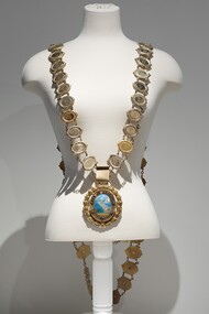 Bayside Gallery - Bayside City Council Art & Heritage Collection
Ceremonial object - Mayoral chain, Lega, City of Brighton Mayoral Chain, 1953
This chain was part of the official regalia worn by the Mayor of the City of Brighton before the amalgamation into Bayside City Council in 1994. The chain was seen as an outward sign of power, authority, and responsibility and was a formal, full-dress type of regalia that was worn by the mayor over their robes at ceremonial functions. The large central drop medallion featured the design of the council seal and the links of the chains detail the name and date of each appointed Mayor. This council seal features the Brighton coastline with a pier extending to the water, a sail boat in the distance and a train on the right of the pier. It was displayed by Council on its flag and letterhead and in municipal buildings and can still be seen on the portico of Brighton Town Hall. The seal was used from 1919, when Brighton was declared a city, until 1970, when an official crest was issued by the British College of Heraldry. Brighton was first incorporated as a borough on 18 January 1859, it became a town on 18 March 1887 and was proclaimed a city on 12 March 1919.9 carat yellow gold and enamel mayoral chain for the City of Brighton. Consists of 61 small oval links, with a scroll listing significant dates in Brighton's history as a centrepiece and a large 'drop' medallion of the City of Brighton seal below. Each oval link has a central plaque inscribed with a mayor's name and dates of their office surrounded by a thin coiled edge and a thick decorative border. The earliest Mayor is W.P. Francis 1918-19 and the latest is K.D. Oliver 1994-95. The links are joined by cable chain and form a long circular chain with two crosspieces of additional links at the back, the upper crosspiece contains four links, while the lower piece contains three links. The chain has a large oval medallion/pendant of the City of Brighton seal which is surrounded by a thin coiled gold edge, a border containing raised lettering 'CITY OF BRIGHTON' above and a Coat of Arms below. This is also surrounded by a coiled edge. The oval piece is then wrapped around with a thick laurel wreath with small berries. The central part of the medallion contains a coloured enamel image of the Brighton coastline with sand in the foreground, a pier extending out into the water, a sailboat in the distance and a train on the right of the pier. The small Royal Coat of Arms of the United Kingdom below includes a coloured enamel shield flanked by a lion and unicorn with a motto inscribed on a ribbon underneath 'DIEU ET MON DROIT'.mayoral chain, city of brighton, lega, ceremonial wear, seal, medallion, mayor, coat of arms, crest, bayside, mayoral regalia -
 City of Kingston
Photograph - Colour, Paul Tresize, 1998
The name Mordialloc was derived from the name Moody Yallock, which comes from the Bunurong language. The Bunurong Peoples are the Traditional Owners of this area. The name means “high water” or “high creek”. In 1839, colonial authorities declared the mouth of the creek, and an additional 830 odd acres as an Aboriginal Reserve, although this proclamation was never gazetted. The reserved land included part of the Carrum Carrum Swamp which was abundant with wild life and natural resources. Regular encroachments, including land sales which began in 1863, were made on the land until 1878 when the Reserve was declared closed, and the land was opened up to land sales. Market gardening and suburban house lots quickly began to develop, and Mordialloc became a renowned picnic and holiday site. Mordialloc Creek is a popular bay side destination for local and visitors, and is a site for boating, kayaking, fishing and swimming, along with many other activities.Colour photograph of Mordialloc Creek, looking out to the bay. Many small fishing and leisure craft are moored on either side of the banks of the creek. To the right hand side can be seen parklands, while the left hand side has a small inlet in which more small crafts are moored.mordialloc, bunurong, traditional owners, suburbs, boats, fishing, waterways -
 City of Kingston
Photograph - Colour, 1998
The name Mordialloc was derived from the name Moody Yallock, which comes from the Bunurong language. The Bunurong Peoples are the Traditional Owners of this area. The name means “high water” or “high creek”. In 1839, colonial authorities declared the mouth of the creek, and an additional 830 odd acres as an Aboriginal Reserve, although this proclamation was never gazetted. The reserved land included part of the Carrum Carrum Swamp which was abundant with wild life and natural resources. Regular encroachments, including land sales which began in 1863, were made on the land until 1878 when the Reserve was declared closed, and the land was opened up to land sales. Market gardening and suburban house lots quickly began to develop, and Mordialloc became a renowned picnic and holiday site. Mordialloc Creek is a popular bay side destination for local and visitors, and is a site for boating, kayaking, fishing and swimming, along with many other activities.Colour photograph of Mordialloc Creek, looking inland.Small fishing and leisure boats are moored on either side of creek, with a view of the Mordialloc Bridge Hotel in the background.mordialloc, bunurong, traditional owners, suburbs, boats, fishing, waterways, hotel -
City of Kingston
Photograph - Colour, Paul Tresize, 1998
The name Mordialloc was derived from the name Moody Yallock, which comes from the Bunurong language. The Bunurong Peoples are the Traditional Owners of this area. The name means “high water” or “high creek”. In 1839, colonial authorities declared the mouth of the creek, and an additional 830 odd acres as an Aboriginal Reserve, although this proclamation was never gazetted. The reserved land included part of the Carrum Carrum Swamp which was abundant with wild life and natural resources. Regular encroachments, including land sales which began in 1863, were made on the land until 1878 when the Reserve was declared closed, and the land was opened up to land sales. Market gardening and suburban house lots quickly began to develop, and Mordialloc became a renowned picnic and holiday site. Mordialloc Creek is a popular bay side destination for local and visitors, and is a site for boating, kayaking, fishing and swimming, along with many other activities.Colour photograph of Mordialloc Creek, looking inland. Boats are moored on either side of the creek and the Bridge Hotel is visible in the background.mordialloc, bunurong, traditional owners, suburbs, boats, fishing, waterways, hotel -
 City of Kingston
Photograph - Colour, Paul Tresize, 1998
The name Mordialloc was derived from the name Moody Yallock, which comes from the Bunurong language. The Bunurong Peoples are the Traditional Owners of this area. The name means “high water” or “high creek”. In 1839, colonial authorities declared the mouth of the creek, and an additional 830 odd acres as an Aboriginal Reserve, although this proclamation was never gazetted. The reserved land included part of the Carrum Carrum Swamp which was abundant with wild life and natural resources. Regular encroachments, including land sales which began in 1863, were made on the land until 1878 when the Reserve was declared closed, and the land was opened up to land sales. Market gardening and suburban house lots quickly began to develop, and Mordialloc became a renowned picnic and holiday site. Mordialloc Creek is a popular bay side destination for local and visitors, and is a site for boating, kayaking, fishing and swimming, along with many other activities.Colour photograph of Mordialloc Creek with boats moored on both sides of the street and Pompei's boat yard visible on the right hand side of the creek., Main Street and St Brigid's Catholic Church are visible in backgroundmordialloc, bunurong, traditional owners, suburbs, boats, fishing, waterways, hotel, church -
City of Kingston
Photograph - Colour, Paul Tresize, 1998
The name Mordialloc was derived from the name Moody Yallock, which comes from the Bunurong language. The Bunurong Peoples are the Traditional Owners of this area. The name means “high water” or “high creek”. In 1839, colonial authorities declared the mouth of the creek, and an additional 830 odd acres as an Aboriginal Reserve, although this proclamation was never gazetted. The reserved land included part of the Carrum Carrum Swamp which was abundant with wild life and natural resources. Regular encroachments, including land sales which began in 1863, were made on the land until 1878 when the Reserve was declared closed, and the land was opened up to land sales. Market gardening and suburban house lots quickly began to develop, and Mordialloc became a renowned picnic and holiday site. Mordialloc Creek is a popular bay side destination for local and visitors, and is a site for boating, kayaking, fishing and swimming, along with many other activities.Colour photograph of Mordialloc Creek with boats moored on both sides of the street and Pompei's boat yard visible on the right hand side of the creek., Main Street and St Brigid's Catholic Church are visible in background.mordialloc, bunurong, traditional owners, boats, fishing -
 Wooragee Landcare Group
Photograph, 28th April 2004
This photograph was taken at Wooragee Hall on Wednesday the 28th of April 2004 as part of an event called 'Queries about Quolls'. This event was hosted by the Wooragee Landcare Group and was led by Andrew Murray, President of the South East Forest Spotted-tailed Quoll Working Group and one of Victoria's leading authorities in quolls. As the name of the event would suggest, this session provided attendees with insight and general information on quolls, including the characteristics of quolls, the habitat of quolls and the techniques that can be used when searching for quolls. This event was likely part of a wider project aimed at protecting the endangered species of the tiger quoll, also known as the spotted-tailed quoll, an animal that once inhabited Mount Pilot-Chiltern National Park. The Tiger Quoll is the largest of the quoll species. Largely resembling a cross between a possum and a cat, the quoll is distinctive due to the white spots that are often found all over its brown fur. This photograph is significant as it provides evidence of a project undertaken by the Wooragee Landcare Group to educate members of the public on the tiger quoll in the early 2000s in an attempt to better understand and protect the species. The Wooragee Landcare Group has been instrumental in the co-ordination of programs relating to biodiversity protection in the local area, providing great assistance to landholders. Portrait coloured photograph printed on gloss paper.Reverse: WAN / NA / OANA2NO / NNN+ / 2 / 8743 / wooragee, wooragee hall, wooragee landcare, wooragee landcare group, quoll, spotted-tailed quoll, tiger quoll, queries about quolls, south east forest spotted-tailed quoll working group, andrew murray quolls, andy murray quolls, mount pilot chiltern national park, quoll species, endangered quoll -
 Wooragee Landcare Group
Photograph, 28th April 2004
This photograph was taken at Wooragee Hall on Wednesday the 28th of April 2004 as part of an event called 'Queries about Quolls'. This event was hosted by the Wooragee Landcare Group and was led by Andrew Murray, President of the South East Forest Spotted-tailed Quoll Working Group and one of Victoria's leading authorities in quolls. As the name of the event would suggest, this session provided attendees with insight and general information on quolls, including the characteristics of quolls, the habitat of quolls and the techniques that can be used when searching for quolls. This event was likely part of a wider project aimed at protecting the endangered species of the tiger quoll, also known as the spotted-tailed quoll, an animal that once inhabited Mount Pilot-Chiltern National Park. The Tiger Quoll is the largest of the quoll species. Largely resembling a cross between a possum and a cat, the quoll is distinctive due to the white spots that are often found all over its brown fur.This photograph is significant as it provides evidence of a project undertaken by the Wooragee Landcare Group to educate members of the public on the tiger quoll in the early 2000s in an attempt to better understand and protect the species. The Wooragee Landcare Group has been instrumental in the co-ordination of programs relating to biodiversity protection in the local area, providing great assistance to landholders.Square coloured photograph printed on gloss paper. Reverse: + 3 8748 / 265 wooragee, wooragee hall, wooragee landcare, wooragee landcare group, quoll, spotted-tailed quoll, tiger quoll, queries about quolls, south east forest spotted-tailed quoll working group, andrew murray quolls, andy murray quolls, mount pilot chiltern national park, quoll species, endangered quoll