Showing 7749 items matching " historical information"
-
 Warrnambool and District Historical Society Inc.
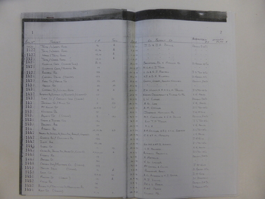
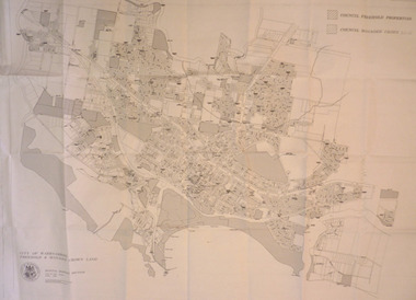
Document, Register Subdivision WCC, Late 20th century
... and therefore is of little historical importance. But the information ...These sheets contain photocopied information on Warrnambool streets and blocks – Allotment numbers and Section numbers, names of developers, date of street construction approval, names of lawyers, Titles Office information etc. They have been originally compiled by Warrnambool City Council staff and concern Warrnambool streets projects from the 1950s, 60s and 70s. This is photocopied material and therefore is of little historical importance. But the information contained therein will be useful for researchers. Document One: These are 57 photocopied pages containing lists of Warrnambool streets and blocks and information on their development. The original information has been handwritten. The pages have been stapled together but the staples have been removed. Document Two: These are twelve photocopied lists of Warrnambool streets with sub-division and development information. The lists have printed plan numbers on the left side and the rest of the information is hand-printed. Two pages have been glued together on one sheet to make six pages. The pages have been stapled together but the staples have been removed. warrnambool streets, warrnambool city council, history of warrnambool -
 Warrnambool and District Historical Society Inc.
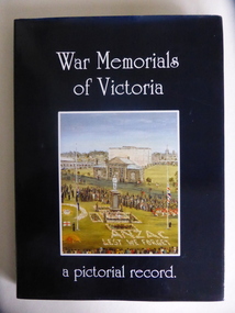
Book, War Memorials of Victoria, 1994
This book gives information on 1,100 War Memorials in Victoria. It was compiled by Bradley, Christey et al and produced for the Returned and Services League of Victoria. War Memorials were established in most settlements in Australia after World War One and added to after World War Two and succeeding conflicts. The number of War Memorials reflect the historical importance of Australia’s involvement in world wars and because of our distance from the battlefields they have become sacred places in Australia – de facto war cemeteries. The book includes information on the Warrnambool War Memorial and those in our area. This book is of interest as it gives details on War Memorials and includes all those in the Western District of Victoria. It will be useful to researchers of social and military history. This is a hard cover book with a blue cover and gold printing on the spine. The dust cover is dark blue with a colour sketch of the Portland War Memorial and white printing on the front cover and an outline of the map of Australia on the back cover. The book has 240 pages, black and white and colour illustrations, a Foreword, Dedication, Acknowledgements, Introduction, Contents, Bibliography and Index and information in alphabetical order of the War Memorials in Victoria. It also has reproductions of 20 oil paintings of Victorian War Memorials by Dacre Smyth.Spine: ‘War Memorials of Victoria’ R.S.L. Victorian Branch’ Front Cover: ‘War Memorials of Victoria, a Pictorial Record’ war memorials in victoria, warrnambool war memorial, history of warrnambool -
 Warrnambool and District Historical Society Inc.
Map - An Angler's map of the Hopkins River Estuary, Angler's map Hopkins River, 1980s
This is a map of the Hopkins River Estuary prepared by Dr John Sherwood for the benefit of anglers. The information on the sheet includes the location of sand banks, the water depths, boat ramp facilities and public access facilities. Some of the information has been gathered from aerial photographs. The map has been produced by the Warrnambool Institute of Advanced Education which was developed in the late 1960s from the tertiary section of the Warrnambool Technical College and with all its departments established by 1984 at the Sherwood Campus five kilometres from Warrnambool on the Princes Highway. Today the site is occupied by Deakin University, Warrnambool campus. The Warrnambool Anglers’ Club has its headquarters on the banks of the Hopkins River near the mouth of the river and the Lyndoch Aged Care facility.This map is of interest as a specialist one, providing fishermen with detailed information on all aspects of the Hopkins river estuary. Fishing has been both a profession and a popular recreational pursuit for Warrnambool residents since the early days of the city’s settlement. The Hopkins River Estuary has been a focal point for fishermen throughout Warrnambool’s history. This is a sheet of paper folded three times to produce a folded map. The front cover has a black and white photograph of two fishermen with a large fish. The map of the Hopkins River Estuary is in yellow, blue and black and covers the side of one sheet and three quarters of the other side. There is an advertisement for the Hopkins River Boathouse with a black and white sketch of the boathouse and notes on the map written by Dr John Sherwood. There are several diagrams showing the water depths. The map has some silverfish damage and some tearing at the folds. warrnambool anglers’ club, history of warrnambool, hopkins river, hopkins river estuary, john sherwood -
 Warrnambool and District Historical Society Inc.
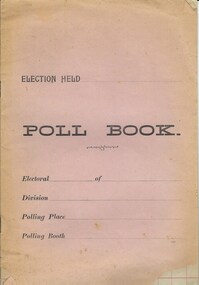
Document, Poll Book, Mid 20th century
This booklet has been produced to record information in connection with an election, presumably that of a local Council. As the title page and the inside pages are blank it is not possible to speculate in what year and for which Council election this booklet was intended for use. This booklet is of no particular importance but may be useful for display. This is a soft cover booklet of 10 pages. The cover is pink but faded around the edges and torn at the corners. The printing on the front is in black type. The pages are ruled with red lines but are blank. There is some silverfish damage on the first page. The pages are bound with metal staples. Front Cover: ‘Election Held’ ‘Poll Book’ ‘Electoral…. of …’ ‘Division…’ ‘Polling Place…’ ‘Polling Booth…’ council elections, history of warrnambool -
 Warrnambool and District Historical Society Inc.
Album, Alexandrie
These post cards of Alexandria, Egypt have been sent by an Australia soldier on active service, probably in Egypt, during World War One. The cards have been sent to Miss May Harvey of Naringal. No information has been found on either the sender of the post cards or the recipient. This album is of considerable interest as it is a local souvenir of World War One, a set of post cards sent to Miss May Harvey who lived in Naringal at the time (about 1916). This is a packet of 24 detachable post cards –black and white photographs of Alexandria, Egypt, produced during World War One. The post cards are intact and have tissue paper protecting each card. The cover is red with gold and black lettering and a black and gold stamped ornamental badge with a circle containing the initials, ‘L. C.’ The post cards have been stapled into the packet. Each post card is labelled in French, as is the title on the front.Front Cover: ‘E. Reed (or Reid)’ ‘Alexandrie, 24 Detachable Phototype Post Cards, Series, N.6’ Back Cover: ‘On Active Service’ ‘Miss May Harvey Naringal P.O. Via Allansford Victoria Australia’ world war one, history of naringal, miss may harvey, warrnambool history -
 Warrnambool and District Historical Society Inc.
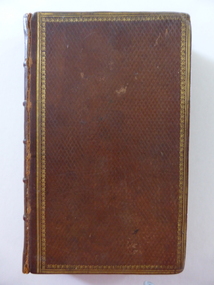
Book, The Lady of the Lake, 1810
This book is an 1810 third edition copy of Walter Scott’s poem, ‘The Lady of the Lake’. It is notable for its illustrations of the drawings of Richard Westall (1765-1836), an English painter and illustrator and Queen Victoria’s drawing master. Westall is best-known for his portraits of Lord Byron. There is no information available on the original owner, the Reverend Matthew West. Tis book is important because: 1. It is an 1810 edition and of antiquarian interest 2. It belonged to Louie Mack, the cousin of Sir Ronald Mack, an important Warrnambool Parliamentarian. Miss Mack was well-known in the Warrnambool area as the Secretary of the Warrnambool Technical School in the 1930s, 40s and 50s. The Macks were prominent early settlers in the Warrnambool area. This is a hard cover leather bound book of 433 pages (poem, ‘The Lady of the Lake’ by Walter Scott). The cover is brown leather with a gold ornamental border. The inside cover has a tan and blue mottled pattern. The book has illustrations with engravings from the designs of Richard Westall. The illustrations have a piece of tissue paper in front of them. The first page has a stamp of the Warrnambool & District Historical Society and there is a loose sheet indicating that the book was published in 1810 and that it belonged to Miss L.A. Mack.‘The Revd. Matthew West, Vicar’s Hall, Clane’. sir walter scott, richard westall, louie mack, history of warrnambool, rev. matthew west -
 Warrnambool and District Historical Society Inc.
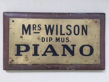
Name Plate, Mrs Wilson Piano, C mid 20th Century
We have limited information on Mrs Wilson, piano teacher except that a Mrs A Wilson operated from Merri Street in 1904. Plaques such as these were hung outside premises to denote where people could access services and were often used by professional people and services. A link to one of Warrnambool's early music teachers.Small brass plate screwed to brown painted wooden board. Rectangular. Metal is stamped with name and details and filled in black.Mrs Wilson Dip Mus Piano. Rennie and Dodds 92 Little Collins St stamped on R H bottom corner . gauranteed filling stamped on lower left edge.warrnambool, mrs wilson piano teacher, mrs wilson pianoforte teacher, warrnambool pianoforte teachers 1904 -
 Warrnambool and District Historical Society Inc.
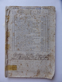
Booklet, Almanac - Advertiser 1873, 1872
This Almanac was published by the Warrnambool Advertiser in 1873. The Warrnambool Advertiser was first published in 1868 by the Warrnambool Newspaper Company with James Hider as chairman. The first editor and publisher was Frank Davis who was succeeded in these positions in January 1870 by Daniel Harrison and Daniel George. The plant and goodwill was sold in May1874 to Fairfax and Laurie, the proprietors of the Warrnambool Standard. The owner of this booklet was Christopher Beattie who came to Warrnambool in 1853 and founded, with Henry Phillips, the undertaking firm of Beattie & Phillips in 1865. Beattie was heavily involved in community affairs in Warrnambool - the Fire Brigade, the Building Society, the Mechanics' Institute, the Manchester Unity Lodge and the Wesleyan Church. Several pages of the booklet have personal notes written by Beattie. The booklet remained in the possession of J J Leahy, the successor to Beattie & Phillips in the Fairy Street undertaking business.This booklet is of major importance as it is an original Warrnambool Advertiser Almanac of 1873. This Almanac was published two years before the Warrnambool Standard Almanacs were issued (1875-1930) and thus it contains information not available elsewhere. The association with Christopher Beattie of the firm Beattie & Phillips and the Beattie handwritten material are also of major interest to local historians.This is a booklet of 47 pages, the Warrnambool Advertiser Almanac of 1873. Some of the first and end pages are missing and some of the inside pages are torn or partly missing. Some of the end pages are loose. The booklet contains a monthly calendar with historical dates from Australia and overseas, Town and District Directories of people living in the Warrnambool area, general information on organisations and businesses in Warrnambool and the surrounding district and postal information. It also has many local Warrnambool and district advertisements, some with black and white sketches. There are also several pages with comments handwritten by Christopher Beattie. The pages have been tied together with string.Christopher Beattie Born on the/ 7th of January 1839 at Westlinton/ (near Carlisle), Cumberland, England 1872 [written in different hand at top of page]beattie & phillips, christopher beattie, warrnambool advertiser, history of warrnambool, james hider, frank davis, daniel harrison, daniel george, fairfax & laurie, henry phillips, j j leahy, undertakers -
 Warrnambool and District Historical Society Inc.
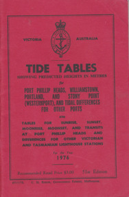
Booklet, Tide Tables, For the year 1976
Yearly publication showing predicted heights in metres for Port Phillip Heads, Williamstown, Portland and Stony Point (Westernport) and tidal differences for other Ports.This booklet provides tide and port information for the coastline of Victoria for the year 1976. It also has information on other aspects of weather such as wind, cloud and sea descriptions. These booklets were a useful reference for fishermen and those involved in boating along the coast of Victoria. They are published in digital form today.Sold at Stan McPhee Sports store Liebig St Warrnambool Vic showing local tides. Red card wrap around cover. 92 cream coloured pages held with 2 staples. Black print. Ports and harbour seal on the frontBooksellers stamp: ink. blue Stan McPhee Sports, green Liebig St Vic. red ...2953. 6717/75. C.H. Rixon, Government Printer, Melbourne. 51st Edition. Recommended price $3.00. Tables for Sunrise, Sunset/moonrise, moonset and transits at Port Phillip Heads & differences for other Victorian and Tasmanian Lighthouse stations.tide table, warrnambool tide table 1976, southern victorian tides -
 Warrnambool and District Historical Society Inc.
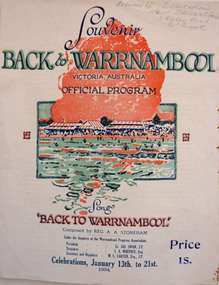
Programme - Back to Warrnambool Souvenir program, 1934
This program provides information for the week of festivities in 1934The Back to celebrations were an important event on the social calendar and this program gives an insight into the kinds of events which were prevalent during the early to mid 20th century. White cover printed in dark blue with red and green accents. Picture of Warrnambool main beach centre front. Back cover is in black and white, Black text at the top reads Warrnambool the Capital City of the West—The city Beautiful. Underneath is a large photo of the Hopkins Falls. The inside four pages contain a brief history of the city, the program for the week and words of the song Back to Warrnambool. A map is on the inside back cover.Particulars supplied by the W’bool Progress Association.warrnambool, back to warrnambool, 1934 official program, reg. a. a. stoneham., reginald alberto agrati stoneham, 1934, program, programme -
 Warrnambool and District Historical Society Inc.
Map - City of Warrnambool Freehold and Managed Crown Land, City of Warrnambool Council, 14th April 1994
This map was drawn up by the City of Warrnambool Council staff to provide information on the land in Warrnambool that was owned or managed by the Council.This map is of considerable importance as it gives information in map form of the Warrnambool land that is owned (freehold) by the City of Warrnambool and the land that is managed Crown land. This is of interest to researchers and those seeking information on specific areas of land in Warrnambool.This map has digital mapping. The map has a white background with black and white mapping details of Warrnambool. It has the City of Warrnambool seal. Scale of map: 1:7500warrnambool city council, warrnambool -
 Warrnambool and District Historical Society Inc.
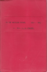
Booklet, On the Western Patrol, Mid 20th century
This is the story told by the Rev. C. Fraser of his two years as a Home Missionary of the Presbyterian Church in the Otway Ranges in 1891-2. The area covered was from Lorne to Peterborough. The booklet includes the names and activities of many settlers of the time and a description of the wreck of the Newfield. This book is of interest to researchers looking for information on the Otway Ranges settlers at the end of the 19th century. It includes names and events and gives an interesting insight into life in the Otway Ranges in the 1890s. This is a small booklet of 44 pages with a red cover and the title printed in black on the front cover. The pages have been stapled together. There are no photographs or illustrations. Front Cover: ‘On the Western Patrol 1891-1892 by Rev. C.A. Fraser’presbyterian church, home missions otway ranges, warrnambool, rev. c. fraser -
 Warrnambool and District Historical Society Inc.
Film - Directory: Microfiche, Port Phillip/ Victoria Directories 1839-1867, Original directories 1839-1867. Microfiche: Circa 1970’s
These microfilms provide information about individuals, towns and businesses in Victoria from 1839 to 1867. A useable resource with information relating to the earliest times in the Port Phillip District.Red covered plastic folder with two inserts containing microfiche. Printed sheet in plastic insert at front.Victoria College Library stamp. Label inside front cover with REF 919.450025.port phillip district, 1839 -1867, businesses in victoria 1839-1867, towns in victoria 1839-1867 -
 Warrnambool and District Historical Society Inc.
Film - Directory : microfiche, Wise's Post Office Directory Victoria, Original directories 1890's. Microfiche circa 1980's
These directories provide information on localities and surnames, services and trade information throughout Victoria. Included in this folder are the following: Wise’s Victoria Post Office Directory 1884-85 Wise’s Victoria Post Office Directory 1888-89 Wise’s Victoria Post Office Directory 1891-92 Wise’s Victoria Post Office Directory1893-94 Wise’s Victoria Post Office Directory 1895-96 Wise’s Victoria Post Office Directory 1897-98 Wise’s Victoria Post Office Directory 1899-00 This directory is a useful resource in researching people and towns of the given areaRed plastic folder with white printed label attached to front cover. Contains smaller card index inserts. Four plastic sleeves containing microfiche. Ref 929.3945 Aus/Nif written in black pen inside front cover wise’s victoria post office directory 1884-85, wise’s victoria post office directory 1888-89, wise’s victoria post office directory 1891-92, wise’s victoria post office directory1893-94, warrnambool history -
 Warrnambool and District Historical Society Inc.
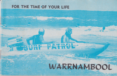
Booklet, For the time of your life Warrnambool, 1975
Tourist brochures have been produced in Warrnambool since the 1890s and this one has been published by the Warrnambool Chamber of Commerce and Industry. Some of the photographs for this brochure come from the Warrnambool Standard newspaper and the information on the car tours was provided by the Warrnambool Tourist Information Centre. Tourism in the Warrnambool region has always been of major importance to the town/city and a local Chamber of Commerce or Tourists’ Association has been active in the area for over 100 years. Today the official tourist guides are produced by the Warrnambool City Council. This brochure is a good example of local tourism promotion in the 1970s and will also be useful for display. This is a small booklet (1975) containing 39 pages. It has local Warrnambool advertisements, maps, photographs, printed material and details of 9 tours that tourists could take by car around Warrnambool. The pages are stapled. The front cover has a blue-tinged image of a surf boat patrol and the back cover has a black and white photograph of Warrnambool’s beach. There is one loose page with a summary of the tourist spots in Warrnambool and a map. Front Cover: ‘For the Time of Your Life – Warrnambool’.tourism in warrnambool, warrnambool -
 Warrnambool and District Historical Society Inc.
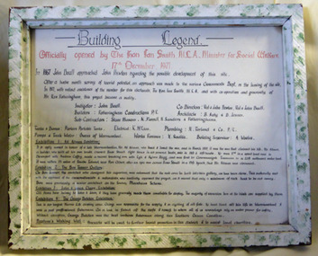
Document - Aquarium Information sheet, Circa 1971
The information on this document shows the inspiration and planning for the building of the aquarium at the Warrnambool breakwater. The instigator was Mr. John Doull, builders Fotheringham Constructions and architects, B. Auty and D Jenner. The Aquarium was opened in December 1971 by The Hon Ian Smith MLA. There were four separate exhibitions and galleries listed on the document. The Aquarium closed around 1998.A local landmark in the latter part of the 20th century with the domes being easily recognized. The people involved in its construction were an important part of Warrnambool’s history.Framed document in green and white speckled wooden frame. Hand written in black on white paper. Subline is written in red.warrnambool history, warrnambool aquarium, john doull, fotheringham constructions -
 Warrnambool and District Historical Society Inc.
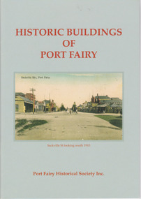
Booklet, Port Fairy Historical Society, Historic Buildings of Port Fairy, 2012
Port Fairy, a small town in Western Victoria established in 1836, has an exceptional collection of public buildings and dwellings dating from the 1840s. This booklet gives short descriptions of 58 of these historic buildings, many with accompanying photographs. These include many buildings in Gipps and Sackville Streets, the Powder Magazine, some hotels, the Drill Hall, Dublin House, the Port Fairy Cemetery and several schools and churches. This booklet is useful for those seeking quick information on the historic buildings in Port Fairy and for those wanting to undertake a walk around the town’s historic spots. TryBooking will show you the full breakdown on the Booking Payment Report and the Event Revenue Itemised Report so you can clearly see the ticket sales, credit card processing fee and the funds that are yours. Front cover: ‘Historic Buildings of Port Fairy, Port Fairy Historical Society Inc.’ Photograph on front cover: ‘Sackville Str. Port Fairy’, ‘Sackville St. looking south 1910’ Back cover map: ‘Port Fairy Historic Buildings’ warrnambool, port fairy, western victoria, historic buildings -
 Warrnambool and District Historical Society Inc.
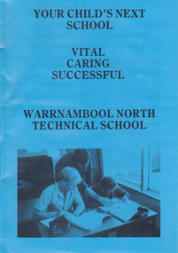
Document - Brochure: Warrnambool North Technical School, Philprint Warrnambool, Late 20th century
This is an information brochure produced for Warrnambool North Technical School. This school operated from 1968 to 1993 when it merged with Warrnambool High School to form Warrnambool College. This brochure is kept as an example of a publicity brochure produced by a local Warrnambool school in the 1980s and 90s. This is an A3 page folded in the middle to make a leaflet of four pages of printed material and photographs. The front cover is blue with an image of two students and a teacher.Your Child’s Next School, Vital, Caring, Successful, Warrnambool North Technical Schoolwarrnambool, warrnambool north technical school, nortec, geoff graham, john tippett -
 Warrnambool and District Historical Society Inc.
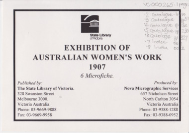
Programme - Microfiche, Exhibition of Women's Work, 1907, Circa 2000
This exhibition was held in October 1907 and ran for 5 weeks. There were over 15000 contributors in the fields of needlework, cookery, Horticulture, fine and applied arts. There was a wide variety of activities, lectures and social events. There were approximately 250,000 people who attended.An important source of work and information relating to a major event in the State of Victoria and in the work of women.Eight sheets of microfilm enclosed in plastic sheet with title page, white with black text.State Library of Victoria Exhibition os Australian Women’s work 1907 6 microfiche. warrnambool, exhibition australian women’s work, 1907 women’s work exhibition -
 Eltham District Historical Society Inc
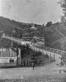
Photograph, Warrandyte Bridge on River Yarra
Bridge across the Yarra River which links North Warrandyte and Warrandyte. A house sits prominantly on a hill in the distance. A wooden building on the side of the road before the bridge has advertising for Wardrop Tailor, Smith Street, Collingwood. It is suggested that the photo has had this fake information added at a later date. Wardrop Tailor did operate from about 1915 to 1921. Alternataive title: Warrandyte Bridge - River Yarra. "Wardrop-Tailor, Smith St. C'wood" sign - faked?This photo forms part of a collection of photographs gathered by the Shire of Eltham for their centenary project book,"Pioneers and Painters: 100 years of the Shire of Eltham" by Alan Marshall (1971). The collection of over 500 images is held in partnership between Eltham District Historical Society and Yarra Plenty Regional Library (Eltham Library) and is now formally known as 'The Shire of Eltham Pioneers Photograph Collection.' It is significant in being the first community sourced collection representing the places and people of the Shire's first one hundred years.Digital imagesepp, shire of eltham pioneers photograph collection, warrandyte, bridge, north warrandyte, yarra river, wardrop tailor, collingwood -
 Eltham District Historical Society Inc
Photograph, Gayle Blackwood, 13 Piper Crescent, Eltham, September 2011
15 born digital images 2 digital files of sales information (Morrison Kleeman)gayle blackwood collection, houses, eltham, piper crescent -
 Eltham District Historical Society Inc
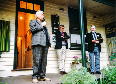
Photograph, Furphy Festival, Kangaroo Ground, 19 May 1996
The Andrew Ross Museum organised Kangaroo Ground’s 1851 – 1996 Furphy week-end which was held Friday May 17th to Sunday 19th May 1996. In commemoration of the district's links with the Furphy family, a plaque was unveiled at the front entry of the Andrew Ross Museum by Roger Furphy of the Furphy Foundary, Shepparton. The event was preceded by an address by author, Dr John Barnes of La Trobe University, the country’s leading authority on the novelist, Joseph Furphy. The date was seen as significant since it marked the 145th anniversary of the death of Judith, the young sister of John and Joseph Furphy, who died soon after commencing school in Kangaroo Ground 1851. Andrew Ross chronicled the event in his reminiscences. The most distinctive product to carry the Furphy brand would certainly be the water cart. The presence of the cart in military camps in Australia and overseas during the First World War led to the name of Furphy becoming an indelible part of our language and idiom. It was used extensively in Europe and the Middle East to carry water to the troops and the drivers of the carts were notorious sources of information and gossip for the men as they moved from camp to camp. As could be expected, not all their news was reliable and so it was that the word Furphy rapidly became a synonym for suspect information or rumour. Source: Kangaroo Ground Chronicle, Vol 1 No 2 Autumn 1996 Note the Shire of Eltham Historical Society Community Banner on display.Five colour photographsandrew ross museum, furphy festival, kangaroo ground -
 Orbost & District Historical Society
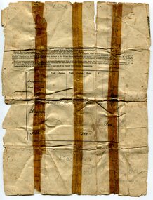
ticket, 1880's
The Potosi was built in Scotland in 1873 by John Elder and Co.It was a cargo/passenger iron screw steamer and sailed from 1880-1887 under the Orient Line Australia service. Samuel James Lynn was born in 1865 in Coleraine, Northern Ireland. Sam left his home in Coleraine in 1883 at the age of 17. (More information in O.D.H.S. newsletter No. 91 September, 2012 by Margaret Hollands) Samuel Lynn was a well-known Orbost pioneer. Ho owned much property throughout the district , bred Clydesdale horses and fattened about 600 cattle. He was in great demand as a judge of both cattle and horses at agricultural shows in Victoria and interstate. He was a shire councillor for 30 years and president several times. He took a great interest in the sporting clubs of the town and played cricket until late in life. He was goal umpire for the local football team for many years, judged for the Orbost Racing Club and was the first president of the Orbost Bowls Club. He was also a member of the first municipal band. A paper passenger's contract ticket for Samuel Lynn on the Steam Ship Potosi from Royal Albert Dock, Liverpool, United Kingdom to Melbourne, Australia. It is white with black print and hand-written details.front - signed "Samuel Lynn"lynn-samuel potosi-steamship -
 Orbost & District Historical Society
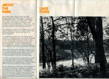
pamphlet, Lake Tyers Forest Park, 1960's
This pamphlet would have been produced as a tourist guide to East Gippsland.This item is a useful reference tool.A three fold glossy, pamphlet titled"Lake Tyers Forest Park". It contains information, a map and black / white photographs of Lake Tyers Park. Print colours are brown, white, yellow and black.pamphlet lake tyers-forest-park -
 Orbost & District Historical Society
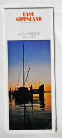
pamphlet, East Gippsland - Last Unspoiled Frontier, 1975-76
This pamphlet would have been produced to encourage tourism in East Gippsland.This item is a useful reference tool.Two pamphlets, titled "East Gippsland _ Last Unspoiled Frontier". On the front is a coloured photograph of a boat moored at a jetty at sunset. Inside are coloured photographs of East Gippsland scenes with black print information.pamphlet-east-gippsland tourism -
 Orbost & District Historical Society
book, Effingham, Wilson, A Geographical Dictionary of the Australian Colonies, 1848
A geographical dictionary or gazetteer of the Australian colonies : their physical and political geography : together with a brief notice of all the capitals, principal towns, and villages. William Wells travelled to Australia as a sponsored immigrant in 1838. Her became a freelance surveyor with an office in Bligh Street, Sydney. He wrote this book in order to better inform the British public on the colonies of Australia. The information contained in the book is both topographical and statistical and was a very useful refernece book at the time.This book is a rare detailed contemporary record of the Australian colonies in the mid 19th century.A hard back 453 pp book with a dark brown patterned cover which has a white label with the title, "Dictionary of Geography" over a map of Australia. It is illustrated with numerous maps and drawings.history-australia wells-william-henry geographical-dictionary-of-the-australian-colonies -
 Orbost & District Historical Society
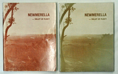
books, Snowy River Mail, Newmerella - Valley of Plenty, March 1978
This book is a useful reference tool on the history of Newmerella.Four copies of a 80 pp soft covered stapled book with a light brown cover with the title, "NEWMERELLA - VALLEY OF PLENTY' in a darker brown print at the top. Below is an illustration of the Snowy River flats. It contains an outline of the history of Newmerella from the beginning of the 19th century until 1978. There are black/white photographs, detailed information and maps.newmerella-history valley-of-plenty -
 Orbost & District Historical Society
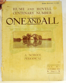
magazine, Clothier & Co, One And All, 1924
This magazine was circulated amongst the pupils, parents, and teachers of the Beechworth Inspectorate, North-East Victoria. This magazine is Vol. 2, no. 3 (Oct. 1924), Hume and Hovell Centenary Number.School magazines were the forerunners of today's school newsletters and were generally published annually. They are contemporary records of the students and staff of the school and usually contain examples of the students' work.This one, published to commemorate the centenary contains information on the Hume and Hovell expedition the purpose of which was to find new grazing land in the south of the colony, and also to find an answer to the mystery of where New South Wales's western rivers flowed. At the centenary of Hume and Hovell exploration in 1924 a committee was formed to co-ordinate and organise local celebrations along the route from Albury to Corio Bay. A roadside cairn was unveiled near Beechworth.A stapled school magazine with a cream coloured cover. It has an illustration of a river and trees reflected in the water on the front. The title, "ONE AND ALL" is at the top in black print. It has " Hume and Hovell Centenary Number" above the title.education-beechworth school-magazine-one-and-all -
 Orbost & District Historical Society
newspaper clippings, February 1971
These articles were compiled by Mary Gilbert who was the first curator of the Orbost Museum and a prominent historian / teacher in Orbost. The 1971 floods at Orbost were the worst on record. At Jarrahmond the river rose to a height of 11 metres and on the flats spread to one and a half kilometres wide. Considerable damage was done to railway infrastructure, roads and farms. More information from the APRIL, 2008 newsletter by John Phillips. (see orbosthistory.com.au)These articles are contemporary records of a significant historical event in Orbost.A manila folder containing black / white newspaper clippings from various publishers. They all relate to the 1971 floods in Orbost. (Details of contents in catalogue 735-900)floods-orbost-1971 -
 Orbost & District Historical Society
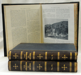
books, Cyclopedia of Victoria, 1903, 1904, 1905
Published in three volumes in 1903, 1904 and 1905 respectively, the full titles read:- The Cyclopedia of Victoria (Illustrated) – in Thee Volumes – An Historical and Commercial Review – Descriptive and Biographical, Facts, Figures and Illustrations – An Epitome of Progress – Edited by James Smith. It was published by The Cyclopedia Company, Publishers, Melbourne. These books are from the estate of Elsie Cooke. Elsie Cooke lived all her life in Gippsland,. She was born at Brodribb in 1895 and died in 1970, Elsie Cooke lived at Bruthen for a short time and, in 1937, moved to live with her aunt, Miss Jean Munro. Miss Cooke was Librarian at the Mechanics Institute for many years. Kindness and consideration for other were Miss Cooke’s attributes and she endeared herself to all who knew her. She was a loyal member of the Presbyterian Church and a stalwart of the Ladies’ Guild, an energetic worker for the Municipal Auxiliary and a member of the Red Cross. This is a significant reference tool as it is a vast source of biographical information.Three volumes of "Cyclopedia of Victoria". They have blue covers, black spines and gold print. The three volumes contain historical details which mention many people and also many biographies and thousands of illustrations including portraits. smith-james cyclopedia-victoria biographies-victoria