Showing 7221 items
matching rite-way
-
 Phillip Island and District Historical Society Inc.
Memorabilia, Phillip Island Memorabilia
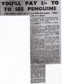
Items used in Research for Book - "Penguin Land" by Gregor BuchananHistorical1162-01 Article from the Wonthaggi Express - Penguin Parade Admission 1162-02 Brochure called "The Short Way to Cowes" detailing taking the train from Flinders Street Railway Station, Melbourne to Stony Point then by Ferry to Cowes 1162-03 Pg 1 & 2 - Souvenir Programme "Music for the People" to be held weather permitting on the Cowes Foreshore at 2pm February 20th, 1955 1162-04 - Card - Drawing of a Fur Seal - one of the 5000-odd Seals on Seal Rocks, as seen from The Nobbies Road House, Phillip Island 1162-05 Pg 1 & 2 - Cowes - Dandenong Road Service showing Daily Road Route and connection from Dandenong to Flinders St. Melbourne. Time Table to and from Cowes to Dandenong"penguin land" book, gregor buchanan, seals, ferry, stony point to cowes, cowes to dandenong, penguin parade, variety concert ticket, tourism -
 Bendigo Historical Society Inc.
Newspaper - JENNY FOLEY COLLECTION: ON A HIGH NOTE
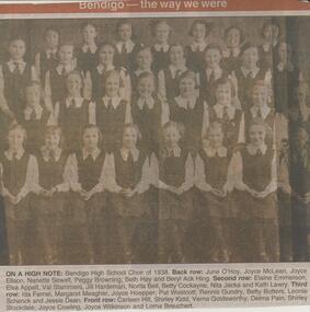
BHS CollectionBendigo Advertiser ''The way we were'' from Monday, May 13, 2002. On a high note: Bendigo High School Choir of 1938. Back row: June O'Hoy, Joyce McLean, Joyce Ellson, Nanette Sewell, Peggy Browning, Beth Hay and Beryl Ack Hing. Second row: Elaine Emmerson, Elsa Appelt, Val Stammers, Jill Hardeman, Norita Bell, Betty Cockayne, Nita Jacka and Kath Lawry. Third row: Ida Farnel, Margaret Meagher, Joyce Hoepper, Pat Westcott, Rennis Gundry, Betty Butters, Leonie Schenck and Jessie Dean. Front row: Carleen Hill, Shirley Kidd, Verna Goldsworthy, Delma Pain, Shirley Stockdale, Joyce Cowling, Joyce Wilkinson and Lorna Breuchert. The clip is in a folder.newspaper, bendigo advertiser, the way we were -
 Vision Australia
Image, National Information Library Service Vision, 200
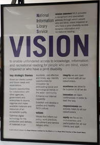
The duplication of services between state based blindness and low vision agencies was not viable in the long term, with telecommunications and technology improving rapidly in the late 20th century. In 1999, a decision was made to merge the library and alternative production services of the RVIB and RBS, as a precursor to a possible larger merger in the future. Thus the National Information Library Service (NILS) was created. As part of establishing a new culture between staff who had retained their positions, a vision, mission and values statement was created under the new service name.1 digital imageNational Information Library Service Mission statement: NILS provides a recognised and specialised gateway through which people who are blind, vision impaired or who have a print disability access dynamic information and recreational reading. Vision: to enable unhindered access to knowledge, information and recreational reading for people who are blind, vision impaired or who have a print disability. Key strategic themes: Know our clients current and future needs and expectations. Explore opportunities for collaboration with other agencies, government and enterprises to source, organise and make available materials and resources of an acceptable quality. Optimise digital technology for the production and delivery of materials in an equitable, cost effective and timely way, identify opportunities for innovation by anticipating social and technological trends in the wider community. Enhance our internal capability. Establish and develop a positive and healthy NILS culture. Values: our values inform our policy, work practices, recruitment and service delivery ethic. Integrity - we are open and honest with all our stakeholders. Excellence - we strive to be superior in all we do. Innovation - we learn continuously in order to lead the way. Responsiveness - we actively listen to all our stakeholders. Equity - we focus on inclusiveness and participation for all our clients and staff. A joint venture between the Royal Victorian Institute for the Blind and the Royal Blind Society of New South Wales. royal blind society of new south wales, royal victorian institute for the blind, national information library service -
 Melbourne Tram Museum
Pamphlet, Rail Projects Victoria, "MetroTunnel Newsletter", May. 2018
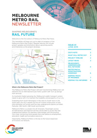
Pamphlet Series of 8 printed and digital documents - titled "MetroTunnel Newsletter issued by Rail Projects Victoria (formally Melbourne Metro Rail Authority). Reports on the changes to the Domain Intersection tram stops, track relocation during Easter 2018 and that the Tunnel boring machines are on the way. The machines are compared to the length and weight of E class trams. Includes station names Anzac Station. Has the logos of the State of Victoria and Rail Projects Victoria. Previous issues: down loaded from the Metro Tunnel website 22-10-2018 Issue 01 - June 2015 - i1.pdf 02 - December 2015 - i2.pdf 03 - May 2016 - i3.pdf 04 - May 2017 - i4.pdf 05 - October 2017 - i5.pdf 06 - May 2018 - i6.pdf - folded A3 sheet - Reports on the changes to the Domain Intersection tram stops, track relocation during Easter 2018 and that the Tunnel boring machines are on the way. The machines are compared to the length and weight of E class trams. Includes station names Anzac Station. 07 - October 2018 - i7.pdf - folded A3 sheets - reporting on work at Federation square and the station locations, some before and after photos and archaeological digs. 08 - September 2019 - i8.pdf - folded A3 sheet - report on traffic changes in Flinders St, the Tunnel boring machines, North Melbourne Station, progress at various sites. 09 - February 2021 - i0.pdf - folded A3 sheet, report on the tunnelling machine progress and a list of dates during 2020 along with notes on the Airport rail line.trams, tramways, metro tunnel, e class, domain interchange, domain junction, anzac station -
 Eltham District Historical Society Inc
Photograph, Stokes family, Nyora Road, Eltham, c.1952, 1952c
Taken from outside the family home on the southest corner of the intersection of Nyora Road and Pitt Street with Eucalyptus Road, looking northeast across the Stokes Orchard L-R: David, Howard, Beryl (kneeling), Dorothy and Gladys Stokes with Gladys's mother sitting in Gladys's father's car with Spot the dog, Nyora Road, Eltham, c.1952 Frank Stokes first traveled to the district by train in 1944 to find land with the intention to establish an orchard. By chance he met Arthur Bird of Bird Orchard (bounded by Pitt Street, Eucalyptus Road and Wattle Grove) and they got talking over their common interest. Arthur put Frank up for the night and pointed out the land, part of Crown Allotment 15, Section 5, Parish of Nillumbik (CA15) somewhat diagonally opposite Bird Orchard. Frank bought the land and for the next two years would travel by train from Melbourne to Eltham every weekend establishing Stokes Orchard and building a home for his family, which they eventually moved into in 1946. In the mid 1970s the Shire of Eltham divided the orchard up into numerous rate-able parcel lots, which became affordable for Frank. As a consequence Stokes Orchard was turned into a housing development by Macquarie Builders and marketed as the Stokes Orchard Estate in two stages; Stage 1 encompassing Scarlet Ash Court, Ironbark Close and Peppermint Grove bounded by Nyora and Eucalyptus roads c.1976 and Stage 2 encompassing Stokes Place, Orchard Way, The Crest and The Lookout bound by Nyora and Diosma roads c.1979. The development of Orchard Way, The Crest and The Lookout did not proceed as planned due to the lack of the sewer along Diosma Road and so many of the proposed lots were incorporated into five-acre parcels instead.Representative of the orchard growing areas of ElthamDigital file only - Digitised by EDHS from a scrapbook (containing commercially printed photos of digital scans) on loan from Beryl Bradbury (nee Stokes), daughter of Frank Stokes.1948-1951 vauxhall velox, 1948-1951 vauxhall wyvern, 1952, beryl bradbury (nee stokes), beryl bradbury (nee stokes) collection, david stokes, dorothy stokes, eltham, gladys stokes, nyora road, spot (dog), stokes orchard -
 Ringwood and District Historical Society
Document, List of bushland reserves in Maroondah - early 2000
Typed document"Attached to List" Hand written note from Helen Moss to Gayle Abbe ( Archivist Ringwood Historical Society) "Here is some information on Dexters Bush and a report I prepared on the bushland reserves in Maroondah which mentions many of the relevant Ringwood reserves. There is also a copy of my phone list for reserves contacts. Roger Lord is listed - so is Anne Kaufman who knows the Angus Avenue/Ruthven Way area very well and may be able to suggest some additions to your heritage list. It would also be worth talking to Eva about the Alexander's land, which is next to Dexter's, on the Dandenong Creek. Good luck, Helen Moss. -
 Federation University Historical Collection
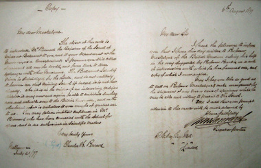
Letter Book, Ballarat School of Mines Outward Letter Book, 1874-8, 1874 - 1878
The Ballarat School of Mines was Australia's first School of Mines, which was established in 1870.Large letter book with rough calf spine and corners, green fabric cover, green marbled end papers, and leather spine labels. Sample letters are shown below Melbourne July 20/77 My Dear Maskelyne, The object of this note is to introduce Mr Barnard the Registrar of the School of Mines at Ballarat to you, and to your Department at the museum as a Correspondent. I presume you still collect specimens all over the world, and from time to time exchange with other museums. The Ballarat School of Mines is subsidized by the State, and is not unlikely to become our chief mining school if indeed it is not that already. As it is in the midst of an interesting geological district it may now and again be able to contribute something rare and valuable even to the British Museum, and on the other hand what is valueless to you may be of greatest use to us. You may place implicit confidence in Mr Barnard who has been connected with the School for years, and is an enthusiast in Scientific matters. Very Truly Yours Charles H. Pearson. P.E. Day Esq M.A. London My dear Sir I have the pleasure to inform you that I have this day written to Professor Maskelyns of the British Museum asking his help in the way suggested by Professor Pearson in a not of introduction with which he has favoured me, and copy of which is now enclosed. May I beg you to be so good as to call on Professor Machelyne make arrangement for the shipment of any case or cases of specimens which the may be able and willing to present to the School. Need I add that your prompt attention to this matter will be much esteemed by Yours faithfully W.H. Barnard Registrar Pro tem ballarat school of mines, correspondence, w.h. barnard, barnard -
 Vision Australia
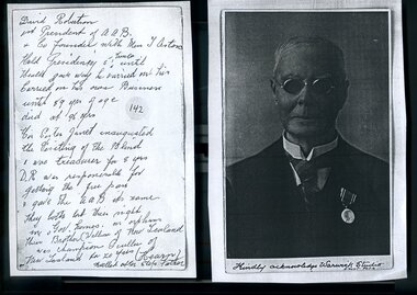
Document - Image, David Robertson
David Robertson (1855-1953) was a founding member of the Association for the Advancement of the Blind and president 1895-1899 and 1913. For centenary celebrations of the Association, portraits were painted of past presidents and photographs gathered in preparation of this. This image was collected, however the donor is unidentified.1 A4 page cut into two with image and notesDavid Robertson 1st President at AAB & Co-founder with Miss T Aston Held Presidency 5 times until Health gave way he carried out his Carried on his own Business until 59 yrs of age died at 96 yrs His sister Janet inaugurated the Visiting of the Blind & was treasurer for 8 yrs D.R. was responsible for getting the free pass & gave the AAB its name They both lost their sight in Gov homes as orphans Their Brother (William of New Zealand was champion Sculler of New Zealand for 20 yrs) (Hearn) called after step father Kindly acknowledge Warwick Studio, Albert Parkdavid robertson, association for the advancement of the blind -
 Flagstaff Hill Maritime Museum and Village
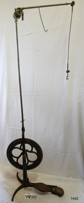
Equipment - Dentist Drill, Late 19th century
The design of this and other similar treadle powered dental engine (or dentist drill) was in common use by dentists from the 1870’s into the 1920's. When electricity became accessible to most communities the electrically powered dental engines began to take over from the treadle power. Over the ages teeth were extracted using picks and scissors and other gouging instruments. Bow drills, hand drills and even a "bur thimble" drill were later used to prepare cavities for filling. Some drills were made bendable by attaching flexible shanks between the metal bur and the handle, giving access to the teeth at the back of the mouth. Other mechanical devices were introduced along the way, such as clockwork drills, but they were hard to handle and inefficient. Over the centuries “dentistry has been performed by priests, monks and other healers. This was followed by barbers; the barber’s chair may well have been the precursor to the dental chair. “(SA Medical Heritage Society Inc.) In 1871 James Morrison patented the first commercially manufactured 'foot treadle dental engine', the first practica dental engine although others had been introduced as early as 1790 (by John Greenwood). Handmade steel burs or drills were introduced for dental handpieces, taking advantage of the significant increase in the speed of the drill. In 1891 the first machine-made steel burs were in use. The treadle drill reduced the time to prepare a cavity from hours to less than ten minutes. In 1876 the Samuel S. White Catalogue of Dentist Instruments listed a 12 ½ inch wheel diameter dental engine, with 14 bright steel parts, for sale at US $55 In today’s market, this is the equivalent to US $1200 approx. The specifications of that dental engine are very similar to the this one in our Flagstaff Hill Maritime Village’s collection. It is interesting to note that workings of a similar treadle dentist drill were used and modified to power a treadle spinning wheel of one of the volunteer spinners at Flagstaff Hill Maritime Village. The foot treadle dental engine was a milestone in dental history. “Historic importance of treadle powered machines; they made use of human power in an optimal way” (Lowtech Magazine “Short history of early pedal powered machines”) The invention of a machine to speed up the process of excavation of a tooth lead to the invention of new burs and drills for the handpieces, improving speed and the surgical process of dentistry. They were the fore-runner of today’s electrically powered dental engines. This treadle-powered dentist drill, or dentist engine, is made of iron and steel and provides power for a mechanical dental handpiece that would be fitted with a dental tool. On the foot is painted lettering naming it "The Brentfield" and there is a fine line of light coloured paint creating a border around the name. The paint under the lettering is peeling off. The drill has a Y-shaped, three footed cast iron base, one foot being longer than the other two. A vertical frame is joined into the centre of the base, holding an axle that has a driving-wheel (or flywheel) and connecting to a crank. A slender, shoulder height post, made from adjustable telescoping pipes, joins into the top of this frame. On the post just above the frame is a short metal, horizontal bar (to hold the hand-piece when it is not in use). A narrow tubular arm is attached to the top of the stand at a right angle and can move up, down and around. There is a pulley each side of the joint of the arm and a short way along the arm is fitted a short metal pipe. A little further along the arm a frayed-ended cord hangs down from a hole. At the end of the arm is another pulley and a joint from which hangs a long, thin metal pipe with two pulleys and a fitting on the end. A treadle, or foot pedal, is joined to the long foot of the base, and joined at the toe to the crank that turns the driving-wheel. The metal driving-wheel has a wide rim. Touching the inside of the rim are four tubular rings that bulge towards the outside of the driving-wheel, away from the pole, and all meet at the hub of the axle. The axle fits between the inside of the driving-wheel and the frame then passes through the frame and is attached on the other side. The driving-wheel has a groove around which a belt would sit. The belt would also fit around a pulley on the arm, at the top of the post. The pulley is joined to a rod inside the arm and this spins the drill's hand-piece and dental tool holder. The foot pedal has a cross-hatch pattern on the heel and the ball of the foot has tread lines across it. The end of the toe and the instep areas have cut-out pattern in them. "The ____/ Brentfield / __ DE IN L___" (Made in London) painted on the long foot of the base. Marked on the drill connection is “Richter De Trey, Germany”flagstaff hill, warrnambool, shipwrecked coast, flagstaff hill maritime museum, maritime museum, shipwreck coast, flagstaff hill maritime village, great ocean road, dentist, teeth, dental drill, dental engine, treadle drill, foot powered drill, treadle engine, orthodontics, dental surgery, james morrison, the brentfield, richter de trey, german dental fitting, london dental drill -
 The Beechworth Burke Museum
Photograph, c.1927-1930
This image shows the Punt (a kind of small boat) that took residents of Bethanga across the Murray River before the Bethanga Bridge was built. Bethanga Bridge was built between 1927 and 1930, and was made a necessity by the building of the Hume Dam. The Hume Dam, formerly known as the Hume Weir, was in construction between 1919 and 1936, which swelled the Murray River into the floodplain to the East of the dam permanently, creating Lake Hume, and isolating the residents of Bethanga and nearby towns, for whom the trip all the way around the new lake to another river crossing was a massive undertaking. The person who wrote on the back of this card instead chose to cross the river on a boat until the Bethanga Bridge became available. Interestingly, partially submerged trees can be seen in the lake in the background of this photograph, illustrating that the dam had already begun to fill the floodplain even before the bridge was built. This photograph shows the methods the residents of Bethanga used while the Bethanga Bridge was being built. This record is associated with the Heritage Listed sites of the Hume Dam and the Bethanga Bridge, and shows the environment during the process of construction and the creation of Lake HumeSepia rectangular photograph printed on matte photographic paperReverse: 1997.3189 / 84 -19 -1 / This is the snap of the Punt. / Our only means of getting out / of Bethanga for the present / Until the bridge is completed / it is 2 miles above the junction / of the Mitta + Murray. It is / 1/2 a mile wide + runs across / the Murray into NSW / Kodak Print / bethanga, bethanga bridge, hume, hume dam, artificial lake, lake hume, hume weir, flood, floodplain, boat, punt, weir, pier, dock, transport, transportation -
 Orbost & District Historical Society
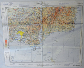
map, 1985
An aeronautical chart is a map designed to assist in navigation of aircraft. Using these charts and other tools, pilots are able to determine their position, safe altitude, best route to a destination, navigation aids along the way, alternative landing areas in case of an in-flight emergency, and other useful information such as radio frequencies and airspace boundaries. World aeronautical charts have a scale of 1:1,000,000 and cover relatively large areas. Orbost Aero Club began in 1969 with Basil Dowie as Chair, David Nixon as Secretary/Treasurer. The group went into recess from 1977-1991 closing in 1997. The mid 1960s were boom years in flying training in Australia and the number of Aero Clubs grew rapidly. The Club played a significant role in the establishment of the small airport at Marlo and in the ongoing operation and development of the airport over the years particularly for patient transfer by aerial ambulance. The Orbost Aero Club Club played a significant role in the establishment of the small airport at Marlo and in the ongoing operation and development of the airport over the years.A laminated map of eastern Victoria. A World Aeronautical Chart. It shows elevations, longitude etc and is designed for pre-flight planning as well as pilotage. Top left hand corner - D.F.N.Nixon VH-FWD 12 Kristine Ct Cheletenham 27/7/87orbost-aero-club aeronautical-map -
 Warrnambool and District Historical Society Inc.
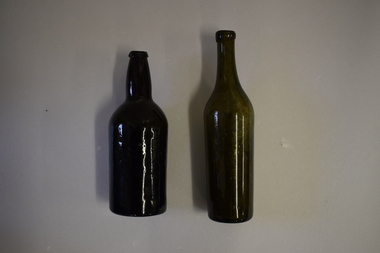
Bottles (2), Bottle, c. 1900
These two bottles were found by workmen building a new retaining wall on the north side of the Les O’Callaghan History House building in Gilles Street Warrnambool. The wall replaced one damaged beyond repair following a car accident in 2019. The building was erected in 1889 as the caretaker’s cottage in the Warrnambool Sea Baths complex (for most of its existence it had two swimming pools, a hot sea water baths building and a caretaker’s cottage). The water in the baths were pumped up from the ocean and, for the hot baths, heated on site. These baths were the municipal baths until the mid 1950s. The bottles may have originated from the one of the families residing in the cottage or from passers-by in the adjoining Merri Street or from patrons of the baths. They appear to be over 100 years old but there is no way the ownership of the bottles can be established.These bottles are of interest as archeological finds after repair works to the Les O’Callaghan History House. .1 A dark green (or black?) glass bottle with a hollowed out concave base, no stopper and a slightly chipped rim on the top. The bottle is stained inside. .2 A green glass bottle with a hollowed out concave base, a moulded top with no stopper and an elongated neck. The bottle is stained inside. warrnambool & district historical society, heritageworks warrnambool, les o’callaghan history house, warrnambool, history of warrnambool -
 Eltham District Historical Society Inc
Photograph, George Coop, Sunnyside Beach, Mount Eliza, c.August 1983, 1983
Possibly an excursion or school camp for Year 8 or 9 students from Nunawading High School to the seaside at Mount Eliza. Nunawading High School opened on Canterbury Road (near Mahoneys Road) in 1955. Enrolments grew rapidly and by 1969 there were over 1,100 students, making it one of the largest schools in the state. In 1989 it was merged with Burwood Heights High and Blackburn South High to become a junior campus of Forest Hills Secondary College. However, the junior campuses were closed in 1997, and the former Nunawading High was bulldozed to make way for a housing estate. "Lost Schools of the 1990s", Learning from the Past, http://learningfromthepast.com.au/lost-schools-of-the-1990s/ George Coop was a teacher of art, craft, wood working and graphics at Nunawading High School until it merged into Forest Hills Secondary College at which point he retired.Digital TIFF file Scan of 35mm Kodak Safety 5062 black and white transparencymount eliza, nunawading high school, sunnyside beach -
 Eltham District Historical Society Inc
Photograph, George Coop, Sunnyside Beach, Mount Eliza, c.August 1983, 1983
Possibly an excursion or school camp for Year 8 or 9 students from Nunawading High School to the seaside at Mount Eliza Nunawading High School opened on Canterbury Road (near Mahoneys Road) in 1955. Enrolments grew rapidly and by 1969 there were over 1,100 students, making it one of the largest schools in the state. In 1989 it was merged with Burwood Heights High and Blackburn South High to become a junior campus of Forest Hills Secondary College. However, the junior campuses were closed in 1997, and the former Nunawading High was bulldozed to make way for a housing estate. "Lost Schools of the 1990s", Learning from the Past, http://learningfromthepast.com.au/lost-schools-of-the-1990s/ George Coop was a teacher of art, craft, wood working and graphics at Nunawading High School until it merged into Forest Hills Secondary College at which point he retired.Digital TIFF file Scan of 35mm Kodak Safety 5062 black and white transparencymount eliza, nunawading high school, sunnyside beach -
 Eltham District Historical Society Inc
Photograph, George Coop, Sunnyside Beach, Mount Eliza, c.August 1983, 1983
Possibly an excursion or school camp for Year 8 or 9 students from Nunawading High School to the seaside at Mount Eliza Nunawading High School opened on Canterbury Road (near Mahoneys Road) in 1955. Enrolments grew rapidly and by 1969 there were over 1,100 students, making it one of the largest schools in the state. In 1989 it was merged with Burwood Heights High and Blackburn South High to become a junior campus of Forest Hills Secondary College. However, the junior campuses were closed in 1997, and the former Nunawading High was bulldozed to make way for a housing estate. "Lost Schools of the 1990s", Learning from the Past, http://learningfromthepast.com.au/lost-schools-of-the-1990s/ George Coop was a teacher of art, craft, wood working and graphics at Nunawading High School until it merged into Forest Hills Secondary College at which point he retired.Digital TIFF file Scan of 35mm Kodak Safety 5062 black and white transparencymount eliza, nunawading high school -
Glenelg Shire Council Cultural Collection
Document - Letter, Patience Whitmore, 1853
From an ABC article about and exhibition containing the letter from Patience Whitmore: The hardships and tragedies often faced by new arrivals are also detailed in this exhibition, especially in a letter written by Patience Whitmore who arrived in 1853... Widowed before she left Britain, she made the trip to Australia with her second husband and children, although two of those children and her second husband died on the way out. She married for a third time after arriving, and that husband also passed away fairly early on, with Patience following not long after. The remaining children were sent off to an orphanage. Even though that sounds like a terrible life, apparently, compared with the life she might've had back in Britain, Patience considered herself to be very lucky, which gives you some insight into what life in Britain must've been like at the time.Letter written by Patience Whitmore in 1853.emigration, 1853, patience whitmore, letter -
 Eltham District Historical Society Inc
Photograph, M. North, Gulf Station, Yarra Glen, 26 October 1986, 26/10/1986
[from EDHS Newsletter No. 51, November 1986:] RECENT ACTIVITIES: The associated events of the September meeting and the bus trip to Gulf Station and Toolangi proved quite successful. Caroline Phillips' talk and slides on Gulf Station were an excellent preparation for the trip. The bus trip was at a more leisurely pace than some we have done. There was adequate time to explore Gulf Station and its re-created old world garden. We also had time to visit the Coranderrk Aboriginal Cemetery at Healesville on the way to Toolangi. At Toolangi we were treated to an excellent guided tour of the "Singing Garden" of C.J. Dennis by Jan Williams, proprietor of the Arden Tea Rooms. As well as describing the various features of the gardens, Jan was able to introduce many anecdotes about the famous poet and his wife (who seemed to have a major responsibility for the creation of the gardens).Seven colour photographsactivities, gulf station -
 Eltham District Historical Society Inc
Photograph, M. North, Mary Reagan (left) and Rita Greenway, Gulf Station, Yarra Glen, 26 October 1986, 26/10/1986
[from EDHS Newsletter No. 51, November 1986:] RECENT ACTIVITIES: The associated events of the September meeting and the bus trip to Gulf Station and Toolangi proved quite successful. Caroline Phillips' talk and slides on Gulf Station were an excellent preparation for the trip. The bus trip was at a more leisurely pace than some we have done. There was adequate time to explore Gulf Station and its re-created old world garden. We also had time to visit the Coranderrk Aboriginal Cemetery at Healesville on the way to Toolangi. At Toolangi we were treated to an excellent guided tour of the "Singing Garden" of C.J. Dennis by Jan Williams, proprietor of the Arden Tea Rooms. As well as describing the various features of the gardens, Jan was able to introduce many anecdotes about the famous poet and his wife (who seemed to have a major responsibility for the creation of the gardens).Colour photographactivities, gulf station -
 Eltham District Historical Society Inc
Photograph, M. North, The old well, Gulf Station, Yarra Glen, 26 October 1986, 26/10/1986
[from EDHS Newsletter No. 51, November 1986:] RECENT ACTIVITIES: The associated events of the September meeting and the bus trip to Gulf Station and Toolangi proved quite successful. Caroline Phillips' talk and slides on Gulf Station were an excellent preparation for the trip. The bus trip was at a more leisurely pace than some we have done. There was adequate time to explore Gulf Station and its re-created old world garden. We also had time to visit the Coranderrk Aboriginal Cemetery at Healesville on the way to Toolangi. At Toolangi we were treated to an excellent guided tour of the "Singing Garden" of C.J. Dennis by Jan Williams, proprietor of the Arden Tea Rooms. As well as describing the various features of the gardens, Jan was able to introduce many anecdotes about the famous poet and his wife (who seemed to have a major responsibility for the creation of the gardens).Colour photographactivities, gulf station -
 Eltham District Historical Society Inc
Photograph, M. North, Azaleas in "The Singing Garden", previous home of C.J. Dennis, Toolangi, 26 October 1986, 26/10/1986
[from EDHS Newsletter No. 51, November 1986:] RECENT ACTIVITIES: The associated events of the September meeting and the bus trip to Gulf Station and Toolangi proved quite successful. Caroline Phillips' talk and slides on Gulf Station were an excellent preparation for the trip. The bus trip was at a more leisurely pace than some we have done. There was adequate time to explore Gulf Station and its re-created old world garden. We also had time to visit the Coranderrk Aboriginal Cemetery at Healesville on the way to Toolangi. At Toolangi we were treated to an excellent guided tour of the "Singing Garden" of C.J. Dennis by Jan Williams, proprietor of the Arden Tea Rooms. As well as describing the various features of the gardens, Jan was able to introduce many anecdotes about the famous poet and his wife (who seemed to have a major responsibility for the creation of the gardens).Three colour photographsactivities, arden, c.j. dennis, toolangi -
 Eltham District Historical Society Inc
Photograph, M. North, Rhododendrons in "The Singing Garden", previous home of C.J. Dennis, Toolangi, 26 October 1986, 26/10/1986
[from EDHS Newsletter No. 51, November 1986:] RECENT ACTIVITIES: The associated events of the September meeting and the bus trip to Gulf Station and Toolangi proved quite successful. Caroline Phillips' talk and slides on Gulf Station were an excellent preparation for the trip. The bus trip was at a more leisurely pace than some we have done. There was adequate time to explore Gulf Station and its re-created old world garden. We also had time to visit the Coranderrk Aboriginal Cemetery at Healesville on the way to Toolangi. At Toolangi we were treated to an excellent guided tour of the "Singing Garden" of C.J. Dennis by Jan Williams, proprietor of the Arden Tea Rooms. As well as describing the various features of the gardens, Jan was able to introduce many anecdotes about the famous poet and his wife (who seemed to have a major responsibility for the creation of the gardens).Colour photographactivities, arden, c.j. dennis, toolangi -
 Kiewa Valley Historical Society
Photograph of Snow Covered Catchment Area Vic, Snow Covered Catchment Area Victorian Alps - 1950s, Circa 1950
This photograph details (early to mid1950s), the Victorian Alpine region when this remote area was part of a "lay back" rural landscape,occasionally visited by recreational adventurers and some wayward tourists. The mountain ranges had provided an adequate barrier against the way-would traveller, but with the opening up of this region by the provision of improved roadways and accommodation facilities, courtesy of the Kiewa Valley Hydro Electricity Scheme, changes such as tourism and its impact upon the "natural" state started to show its side effects (clearing of the land). The expansion of the European immigration numbers (1950s) coming into Australia was increasing after World War II which not only provided increased construction workers to the region but also immigrants who appreciated alpine regions. Some of these immigrants contributed to the expansion of the region and provided for a greater degree of diverse professions and rural related work force.This photograph depicts the borderline in time between an exclusively rural based population and respective activities(early 1900s)to the present (2000 on wards) integrated village, tourist and retiree/holiday area. The time when land was exclusively used in agriculture and Alpine grazing lands is over. The Kiewa Valley is loosing its hiding place and is becoming more and more a source of untapped residential land and winter time recreational adventure lands. The changes brought about by modern technologies involving recreational activities such as hang gliding, gliding (local airstrip), mountain bikes, car rallies and their associated clubs is providing for an increased short term population boost. These together with the attractions for retirees is changing not only the physical nature of the Kiewa valley but also its "soul".This item is a black and white photograph of a section of snow covered catchment area in the Victorian Alps in the mid 1900. It is on 200 gms paper but not on photographic paper and has a white boarder (3 mm).kiewa valley tourism, victorian alps, alternate energy supplies, alpine population growth -
 Orbost & District Historical Society
photograph, 1937
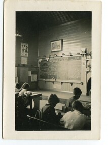
In 1912 the school at Pumpkin Point opened to serve the children of farmers living in the Bete Bolong district. This meant a big change in their way of life because in the past the children had been rowed across the Snowy River each day to attend school at Jarrahmond. Myrtle Bunting was the first HT of the school which had been erected on a block of land purchased from H. Richardson. The school functioned until 1952 when a shortage of pupils caused its closure. As a bus service to Orbost now operated, the school at Pumpkin Point faced permanent closure. J. McKeown bought the building. Students attending the school at this time included Russells, Johnstones, Reeves, Healeys, Kavanaghs, Phillips, Rodwells, Mills, Baileys, Gilberts and Masons. Mr. Oswald S. Green taught at Bete Bolong State School until he was appointed to Rokewood Junction in August 1937.This item is associated with the history of education in the Orbost district. There is no longer a school at Bete Bolong.A small black / white photograph of students sitting in a classroom.on back - "Bete Bolong School, 1937. O.S. Green was H.T."bete-bolong-school pumpkin-point green-o.s. -
 Orbost & District Historical Society
photograph, 1937
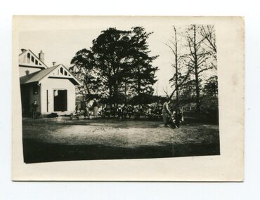
In 1912 the school at Pumpkin Point opened to serve the children of farmers living in the Bete Bolong district. This meant a big change in their way of life because in the past the children had been rowed across the Snowy River each day to attend school at Jarrahmond. Myrtle Bunting was the first HT of the school which had been erected on a block of land purchased from H. Richardson. The school functioned until 1952 when a shortage of pupils caused its closure. As a bus service to Orbost now operated, the school at Pumpkin Point faced permanent closure. J. McKeown bought the building. Students attending the school at this time included Russells, Johnstones, Reeves, Healeys, Kavanaghs, Phillips, Rodwells, Mills, Baileys, Gilberts and Masons. Mr. Oswald S. Green taught at Bete Bolong State School until he was appointed to Rokewood Junction in August 1937. This photograph is associated with the history of education in the Orbost district. There is no longer a school at Bete Bolong.A small black / white photograph of students and teachers standing outside a school.on back - " Bete Bolong School , 1937"bete-bolong-state-school education-orbost -
 Orbost & District Historical Society
household items, 1935-1960s
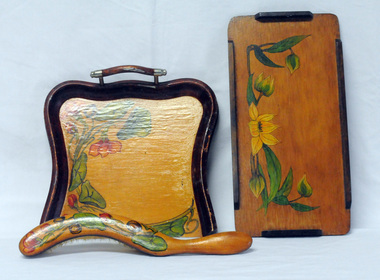
These items are from the estate of Norma Adelaide Scott (nee Johnston) ,January 2, 1925 - May 18, 2018 (93 years old) who died in Orbost. Norma was part of the Morris family who came to Newmerella in 1888, had land on Grandview Road and on the flats. Mr Morris had been a school teacher at Lake Tyers Mission before coming to Orbost. "Bobs y’r Uncle" was a nursery rhyme game designed by Frank H. Simpson for John Waddington Ltd. in 1935. The game was especially designed for children. The cards had scenes from nursery rhymes and six cards were needed to make up each rhyme in a set. Games turned out to become an important part in the progress of Waddingtons, who eventually acquired the rights to Monopoly in the UK, and then published Cluedo, opening the way for their supremacy in the toy industry These items are examples of common household items used in an Orbost family in the first - mid 20th century.3228.1 is a wooden tray with handles. The tray is lacquered and hand - painted with green leaves and orange flowers. 3228.2 is a brush with a curved wooden handle, lacquered and decorated in a similar pattern of green leaves and flowers. 3228.3 is a small wooden tray, lacquered and hand -painted with green leaves and yellow flowers. It is a rectangular shape with raised edging attached on the four sides. 3229.4 is a pack of cards in a red box with a cartoon type drawing of a man wearing a checked coat and hat holding two dogs on leashes.3228.5 is an orange / white cardboard box containing a pair of nylon stockings: box labelled " 'KOLOTEX/ Free-n-eezy" stockings.3228,5 - in orange and white print - "KOLOTEX/ Free-n-eezy/ Clings/ 40 denier/ SEAMLESS/ S-T-R-E-T-C-H" and in black - "NEW guaranteed never to ladder"scott-norma cards-playing hosiery-kolotex-stockings trays-wooden household