Showing 5349 items matching " timber"
-
 Seaworks Maritime Museum
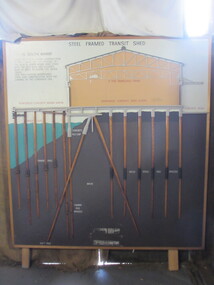
Diagram
Cross section of wharves and steel framed sheds built along the Yarra river between the 1920s and 1960s. The South Melbourne side of the Yarra River is reclaimed swamp land. Without a solid foundation for the construction of the wharves and transit sheds, extended piles were sunk into the mud to support the wharf and shed structures. An example of this design may be found at 5 South Wharf which was built in the 1930s. The transit sheds gave shelter for cargo while waiting to be loaded onto a ship or to be collected by truck after being unloaded from a ship. The transit shed became surplus to requirements with the introduction of containers.Wooden diagram of a transit shed featuring a shed sitting atop mud with some water. It shows the splices sitting in the mud to support the shed. "Steel Frames Transit Shed/ 15 South Wharf/ Model of Typical wharf construction/ of 1940- made for the opening of/ the "new" 15 South wharf shed (1944),/ Note the deep piles and elevated/ rear of the shed to allow for the truck/ trays./ This shed feature disappeared/ from port construction with the/ coming of the container era/ reinforced wharf apron/ 3 ton travelling crane/ reinforced concrete shed floor/ concrete road/ water level/ concrete pile cap/ cradled piles/ timber pile splices/ mud/ mild steel pile splices/ 110 ft pile" "On loan from Port of Melbourne Authority" -
 Flagstaff Hill Maritime Museum and Village
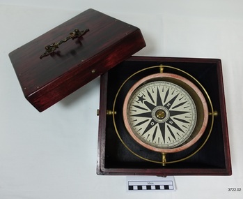
Functional object - Compass, mid-19th Century
Captain Robilliard: James Arthur Robilliard was a sea captain and tentmaker, born on the 19th April 1843 at Saint Helier, Jersey. He trained there in his father's sail loft as a sailmaker. His first job as a sailor was in Liverpool, England and 1875 James Robilliard migrated to Australia as mate on the "E.M. Young". James Robilliard and his family were amongst the early settlers that arrived along the Curdies River in the Heytesbury district of Western Victoria. In 1877 he became a Captain and would have used his compass from ship to ship. On 28th May 1877 in that same district a small 3-masted, schooner the "Young Australian" was wrecked. This schooner had been built 1864 at Jervis Bay, NSW. She had been on her way from Maryborough Queensland to Adelaide, under the command of Captain Whitfield, when she lost her mainmast in a heavy gale. She was beached at Curdies Inlet in Peterborough, Victoria, Captain Robilliard was placed in charge of the salvaging operation and recovered a good portion of the cargo. Not long after this incident a Warrnambool shop owner David Evans found employment for James Robilliard with Evan Evans, who produced tents, sails, tarpaulins and similar goods; James already had the necessary skills for this work. Evan Evans was the same sailor rescued from the “Young Australian” soon after his rescue Evan recalled he had a relative in Australia in a town called Warrnambool and while walking in Timor Street, Warrnambool, he saw a sign over a shop that said “David Evans” and once the two men met, Evan was warmly welcomed. David then helped his relative to establish a tent and tarpaulin-making business there. Evan later transferred his successful business to a shop in Elizabeth St, Melbourne, under the name Evan Evans Pty. Ltd.) James Robilliard, a committed Christian, and accredited Lay Preacher with the Methodist Church. He travelled around the local district leading the settlers in worship. On 14th November 1879, Captain Robilliard married Helen Beckett. Alfred and Selina Beckett and their family all attended the church at Brucknell where Captain Robilliard preached. He was said to have been taken by their young daughter Helen. James and Helen had ten children; James Arthur (Jnr), Henry William, Nellie Jessie, Alfred Albert, Rubena Nellie, De Jersy Norman, Clifford Beckett, Olive Ida, Frances Ridley Havergal and Nellie Elvie, all born in Victoria. In the 1880s James Robilliard captained the cutter "Hannah Thompson" into Port Campbell, Victoria. This vessel was the first coastal trader to operate between Melbourne and Port Campbell. At one time Captain Robilliard had to beach the "Hannah Thompson" for repairs. In 1923 she was blown ashore in a gale and wrecked at Oberon Bay, at Wilson's Promontory. In 1889 the compass was saved by Captain James Arthur Robilliard from his sinking brigantine "Mary Campbell" in 1889. This vessel was used to carry equipment for the Sydney Sugar Refinery's Mill in Southgate, NSW. The ship had been built in 1869 and traded for the next 20 years between Australian ports and rivers along the east coast as well as regular ports in New Zealand. She was recognised by the Sydney Morning Herald as one of the best "carrying vessel in the timber trade". She had several owners over this time, the last one being Captain James A. Robilliard. On 29th April 1889 the "Mary Campbell", with Captain James A Robilliard as captain and owner, was on her way from Clarence River, NSW to Melbourne, Victoria with a cargo of railway girders for the Melbourne Harbour Trust. Captain Robilliard encountered a storm off Port Macquarie. He sailed the vessel south to about 40km east of Cape Hawke, near Tuncurry. At around 7 pm, he discovered that the cargo had shifted during the storm and the heavy girders had damaged the hull, causing a leak. The pumps were inadequate to stem the fast-flowing leak water soon filled the hull during the next two hours. Some of the crew began throwing the cargo overboard to lighten the vessel, hoping to keep it afloat until daylight. When the water reached over 2 meters in the hull they realised their efforts were in vain. On the 30th April 1889, the crew left the vessel the ship was sinking fast, so they made for the shore. While still miles off Cape Hawke all seven crew members, including the Captain, were rescued by the Government Tug "Rhea" and taken to Port Macquarie Hospital and later returned to Sydney in the vessel "Wellington". No cargo had been saved and the consignment had been under-insured, only covered for half its value. The name of the last ship Captain Robilliard sailed is currently unknown, however, he sailed that ship from the port of Marlborough, Queensland, carting steel railway girders for the Geelong-to-Camperdown railway line. On this trip the ship hit a storm, the cargo shifted and the ship was wrecked along the NSW coast. After this, Captain Robilliard retired from the sea and began farming in Peterborough. In about 1897, verging on retirement, Capt. Robilliard superintended the Melbourne Sailors’ Home in Spencer Street, Melbourne, before being asked to leave this position in 1902 for trying to shut down a local hotel. On 6th May 1917 Captain James Arthur Robilliard J.P. died at Blackwood Park, in the Cobden district of Brucknell, the first Robilliard family homestead in Australia. He was buried in the Melbourne General Cemetery, Victoria. His wife Helen passed away in 1947. This compass, once belonging to Captain James Arthur Robilliard, is of local and state historical significance for its use by the Captain with his vessel the "Mary Campbell", a trading vessel that was bringing railway girders to the Melbourne Harbour Trust. He also used this compass on the "Hannah Thompson", listed on the Victorian Heritage Register and known as being the first coastal trader to operate between Melbourne and Port Campbell. The compass is also a very fine example of maritime navigational instruments manufactured and used in the mid-19th century. Marine compass, brass, in wooden box with separate, fitted lid. The compass card has sixteen points. The four principal points are marked; North with a star shaped, South with an “S”, East with and “E” and West with an “O” (French word OUEST). Each quadrant of the circle is numbered from 0 – 90 degrees. The card is floating in a liquid. The compass gimbal is attached to the sides of the box and to the front and back of the compass’ cylindrical brass frame. The mahogany coloured timber storage box is joined with brass nails. The centre of the lid has a folding decorative brass handle. The lid fits over base and closes with a brass screw and hook on both front and back. Maker; Dubas Watchmaker Optician, Nantes, France, c 1860-1870. Compass came from the ship “Mary Campbell”, which sank off the NSW coast in 1889, near Forster. The compass, as well as the ship, belonged to Captain James Arthur Robilliard and was donated by his family. “DUBAS MANTES” stamped into side of gimbal. “DUBAS HORLOGER OPTICIEN. NANTES.” printed around centre of card. flagstaff hill, warrnambool, shipwrecked coast, flagstaff hill maritime museum, maritime museum, shipwreck coast, flagstaff hill maritime village, great ocean road, marine compass, navigation instrument 19th century, marine instruments, dubas mantes, captain james arthur robilliard, j.a. robilliard, helen beckett, ship young australian, ship young australia(n), ship hannah thompson, ship mary campbell, melbourne sailors home, david evans, evan evans, curdies inlet, brucknell church, curdies railway, great lakes museum -
 Ballarat Clarendon College
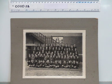
Photograph, 1923 (exact)
This named photograph is an excellent record of the 80 strong student cohort of 1923. There are 6 adults in the photograph. Principal Major A.S.M. Polson is clearly identified. Top row (Left to right) G Den – E Beacham – J B Coutts – J C Besemeres – G Naismith – M Levy – G N Witter – J C Loughrey – G Bredby – A P McLean – B Currie – W A Kilpatrick – G Clark – E Wearne – R Monteith 2nd row from top L T Wotherspoon – W A Stickland – E Campbell – A Bell – H Thomas – W A Paterson – E? Lyne – J Leishman – E J Forbes – J M Gray – J H Burr – J Creer - ? – C? Morgan – J Hammon 3rd row from top D A Miller – A G Shaw – W John – J Moorhouse – G L Scott – A Levy - ? Ford - ? Gill – T G Dowling – D Campbell – W McLean – J E Coutts - C? Carthew – D Douglas – A L McLean 4th row from top A M Greenfield - ? - M Featonby – G Leishman – J Woodward – Mr F R Potts BSc – Mr D S Coutts BA – Mr A S M Polson Principal – Miss Gilbert – Mr G Hay – A J Besemeres - ? - ? – R G Bradby – H F Brind 5th row from top R Buchanan - ? – M Symons – J Riddle - ? Goon - ? Symons - ? Komesarook - ? Fairey - ? – B Ronaldson - ? Buchanan - ? - ? – M Whiteside – Pat Shaw – J Groat - ? Front G P Jeffrey - ? Goon – R G Dowling – H M Greenfield – G Dale – A Hall-Jones – A Baker – J L Price – K McLean – E M Price Mounted black and white photograph of the Ballarat College student cohort in 1923. Cohort are arranged on tiered rows in front of timber external staircase. First row sitting cross-legged on ground. Second and third rows seated. Fourth, fifth and sixth standing on tiers. The photograph is mounted on grey cardboard. J. M. Gray written in ink on back of mount. Pencilled initials 'J.M.' also on back of mount. Photograph is accompanied by photocopy of photograph and handwritten papers detailing names of those in photograph. These papers are signed by Grant Coutts. J. M. Gray is identified as tenth from left on second top row. J.M. ballarat, 1923, college, j m gray, major a s m polson, student cohort -
 Ballarat Clarendon College
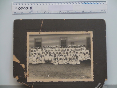
Photograph, 1908 (estimated)
This extraordinary record of the student cohort in 1908 reveals many aspects of school life in the early 1900's. The fashions, hair coiffure and accessories and added costuming are fascinating. The sport detail from the basketball hoop is significant. This photograph has social significance because of its detail regarding female school activities in the early 1900s. Black and white photograph mounted on grey card of Clarendon Ladies College student cohort in 1908. The students are arranged in five tiered rows. The photograph is taken against wall of a timber building. There is a basketball net fixed to the wall above the last row. Many of the girls are wearing fancy hats, some decorated with birds. Two young girls in the front row wear poster boards over their clothing advertising an event not to be missed; something to do with a menagerie. All the students are dressed in white, some in dresses, some n skirts and blouses and many have aprons over their skirts. The photograph is accompanied with a typed list of namesPrinted on front righthand bottom corner of mount: 'Richards & Co/Ballarat'1908, uniform, richardson, clarendon ladies college, costume, menagerie, hilda farmer, avenel halls, sylvia eyres, ella morrow, florence sides, gertie owen, laela williams, lorna dowler, emma buchanan, phyllis doepel, daisy llewellyn, adeline purser, sophie anderson, helen mathieson, d brophy, lily wright, margaret dowler, dulce deardon, gladys small, marjory howe, jessie kelsall, erica mckay, pearl eyres, iris llewellyn, edith bishop, marjorie walker, violet howard, hazel wlls, effie white, mimi murphy, carrie miners, edith murphy, irene palamountain, miss allan, marjorie salmon, dollie snow, naomi franklin, elsie powell, rachael kennedy, rose paull, sylvia barnett, esther, lilah emblling, trixie kliender, chrissie anderson, agnes wheen, kitty dawbarn, hazel clements, m serjeant, dolly gill, beryl bach, dorothy nicholas, frances gill, meg moore, jessie eyres, blanche murphy, merle booth, melba mcconnel, edna clark, betty lester, bessie hoad, madge dearden, kate cameron, olive mathews, grace nicholas, mollie souter, isabel mctaggart, madge llewellyn, mollie mary buley, alice ralph, ruth tyler, rebecca abraham, joyce eyres, nellie salmon -
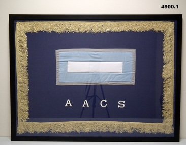 Bendigo Military Museum
Banner - BCOF BANNERS, FRAMED, Banners c 1946 - Frames 2022
1. "AACS" - Australian Army catering Service. 2. "RAE" - Royal Australian Engineers. 3. "A FLD BTY RAA" - Royal Australian Artillery B.C.O.F. Japan 1946-1948.1. BANNER FRAMED, COTTON FABRIC, BLUE BACKGROUND, PALE GOLD COLOURED TASSLE FRINGE, WHITE EMBROIDERED INSCRIPTION, COLOUR PATCH CENTRE, GREY, PALE BLUE AND WHITE. 2. BANNER FRAMED, COTTON FABRIC, MID BLUE BACKGROUND, GOLD COLOURED TASSLE FRINGE, WHITE EMBROIDERED INSCRIPTION, COLOUR PATCH CENTRE, FUSCHIA WITH GREY SURROUND. 3. BANNER FRAMED, COTTON FABRIC, NAVY BLUE BACKGROUND, WHITE COLOURED TASSLE FRINGE, WHITE FABRIC INSCRIPTIONS, COLOUR PATCH CENTRE, RED AND BLUE WITH GREY SURROUND. 1,2,3, Frames - timber, block colour print, glass front, cardboard backing.1. White embroidered inscription. AACS. 2. White embroidered inscription, "RAE/6 Welding PLT/10 Bomb disposal/13th Army Troops/14th WKs PKs/1st AWT/17th CRE/42 & 43 Port Operating/28th FIELD COY" 3. White fabric inscription. "A FLD BTY RAA"/ "345 Aust LAD".military, ww2, japan, banners -
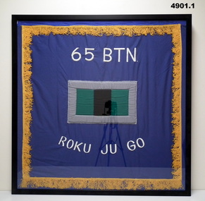 Bendigo Military Museum
Banner - BCOF BANNERS, FRAMED, Banners c 1946. Frames 2022
Banners - BCOF - British Commonwealth Occupation Force (Japan) 65/66/67th BTNs Formed in the islands from the 7th Division AIF for service in Japan 1946 - 48.1. BANNER FRAMED, COTTON FABRIC, BLUE BACKGROUND, GOLD COLOURED TASSLE FRINGE, WHITE EMBROIDERED INSCRIPTION, COLOUR PATCH CENTRE, GREEN AND BLACK WITH GREY SURROUND.. 2. BANNER FRAMED, COTTON FABRIC, DARK BLUE BACKGROUND, GOLD COLOURED TASSLE FRINGE, OFF WHITE INSCRIPTION, COLOUR PATCH CENTRE, GREEN AND PURPLE WITH GREY SURROUND. 3. BANNER FRAMED, COTTON FABRIC, BLUE BACKGROUND, GOLD COLOURED TASSLE FRINGE, WHITE EMBROIDERED INSCRIPTIONS, COLOUR PATCH CENTRE, GREEN AND BROWN WITH GREY SURROUND. 1,2,3, Frames - timber, black colour print, glass front, cardboard backing.White embroidered letters and numbers - 1, "65 BTN. ROKU JU GO" Fabric letters and numbers - 2. "66 BTN. ROKU J.U. ROKU" white embroidered letters and numbers - 3. "67 BTN. ROKU JU NANA" military, ww2, japan, banners -
 Bendigo Military Museum
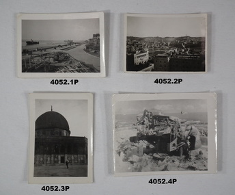
Photograph - PHOTOGRAPHS WW2, C.WW2
Collection relates to Harold Johnson TX3956. Refer to Cat. No. 4053.3 for service details..1) Photo, black & white, harbour scene showing two ships, one at lean, buildings and timber on wharf. Hand writing on rear. .2) Photo, black & white, view over Jerusalem towards hills. .3) Photo, black & white, close up of a mosque with one person in front. .4) Photo, black & white, bombed wreckage of a gun emplacement overlooking a harbour. .5) Photo, black & white, air strip with covering and a plane coming into land, background appears to be jungle. .6) & .7) Photo, black & white, Japanese surrender being conducted aboard a ship. Photos are various sizes. .1) On rear in pencil "Close up of the wreck, Love Hal xxx" .2) On rear in pencil "View of Jerusalem from YMCA" .3) On rear in pencil "Mosque of Omah Jerusalem Love Hal xxx"photographs, jerusalem -
 Warrnambool and District Historical Society Inc.
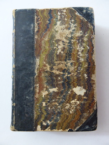
Book, The Practical Measurer, 1863
This book, ‘The Practical Measurer’, by Alexander Peddie, is subtitled ‘Tradesman and Wood Merchant’s Assistant’. It is a tradesman’s guide to measuring and contains many tables of measurement. The inscription in the front of the book shows that it belonged to Thomas Osborne and that he obtained it from D. McColl who is identified in the inscription as the Chief Engineer of the steam ship, ‘Julia Percy’. There is a record of a Donald McColl owning the vessel ‘Mimmie Dyke’ and sailing it to Mauritius in 1856 and there is also a record of the death of a Donald McColl in 1880 so these two facts may refer to the D.McColl mentioned by Thomas Osborne (especially as he refers to him as ‘poor old Mr D. McColl’). Thomas Hamilton Osborne was born in Port Fairy in 1851. He had a lifelong interest in ships and in Warrnambool was the Secretary and then Manager of the Western Steam Navigation Company for 16 years. Osborne wrote many articles with nautical themes using the nom-de-plume of ‘Sliding Gunter’ and had a great love of, and interest in, the ship, ‘Julia Percy’ and when he died in 1902 his body was put on board the ‘Julia Percy’ and he was buried at sea. The ‘Julia Percy’ (built 1876) was a well-known steamship on the western Victorian coast for many years. Later it plied the Queensland coast, saw service in West Australian waters, was renamed the ‘Leeuin’ and was used as a coal hulk until it was scuttled in 1935. The signature in the book of T. Hyland may indicate that he donated the book to the Warrnambool and District Historical Society. This book is of prime importance because:- 1. As a book printed in 1863 it is of antiquarian interest. 2. The connection with Thomas Osborne is of key interest as he was a notable figure in Warrnambool’s 19th century history, especially in maritime circles. 3. The connection with the ship, ‘Julia Percy’, is of particular interest as it was a prominent ship in Warrnambool’s maritime history. This is a hard cover book of 448 pages with brown and gold leather binding on the spine and cover edges and a brown and tan mottled pattern cover. The book has a Preface, a Contents page, information on how to measure all types of solid figures and how to measure work involved in the various trades – masons, carpenters, painters, glaziers, plumbers etc. It also has two Appendices with information on the measurement of sawn timber. The text has many tables and diagrams. The first page has a handwritten inscription in black ink and the back pages have some mathematical calculations written in pencil and a mathematical problem with its solution written in ink. Handwritten: ‘T. P. Hyland’ Stamped: ‘T.H.Osborne’ Typed label: ‘Mr T. H. Osborne, Warrnambool’ Handwritten: ‘T.H. Osborne, Warrnamool, Australia, given to me by poor old Mr D. McColl, Chf. Engineer, Julia Percy S.S., 1888’ thomas osborne, history of warrnambool, maritime history of victoria, ‘julia percy’ steamship -
 Flagstaff Hill Maritime Museum and Village
Container - Trinket Box, Johann A. Landmann, 1853
This trinket box was made by Johann Landmann during his journey on the sailing ship Wilhelmsburg and was donated to Flagstaff Hill by the wife of Landmann's great-grandson. Landmann (or Landman, also known as August Landmann) was born in 1826 in Ganhor, Silesia, Prussia. At the age of 20, he travelled through Europe, working from town to town as a cabinet maker. At 26 years old he returned to Germany, married Anna Rosina in Wahlstatt, Prussia, and on the same day sailed for Australia on the Wilhelmsburg in 1853, the year the ship was registered. The Wilhelmsburg was a three-masted, square-rigged sailing ship built at Reiherstieg, Hamburg, and registered in Hamburg on 27th April 1853. On her maiden voyage in 1853, the ship sailed from Hamburg, Germany, to Australia with 510 passengers on board, including emigrants under the Bounty Scheme. Johan Landmann was one of the passengers. The Wilhelmsburg arrived in Hobson’s Bay, Melbourne after sailing for 100 days. Johann spent a week in Melbourne then travelled to Warrnambool aboard the Merry Kitty, arriving fourteen days later. Johann had landed in Melbourne with only 16 shillings in his pocket and by the time he arrived in Warrnambool, he only had one shilling and sixpence left. He also had very limited ability to speak English. He settled in the Allansford area, near Warrnambool, together with other families from Germany and went on to play a significant role in the history of Warrnambool. Johann worked as a cabinet maker in Warrnambool, making the first coffin in the Warrnambool cemetery. He also worked as a general merchant. He built many of the earliest shops in Warrnambool, and the first paddle boat used on the local Hopkins River. He made models of Warrnambool’s Ozone Hotel and Presbyterian Church; the model of the Hotel is now in the Warrnambool Art Gallery, and the model of the Presbyterian Church has been in the care of the Warrnambool & District Historical Society since around 2017. One of Landmann's residences was a two-storey building in Henna Street Warrnambool where he, lived upstairs and operated his business downstairs. After he retired Landmann built a ‘handsome stone residence’ at 30 Mickle Street, Warrnambool, where he lived until his death in June 1920; he was aged ninety-five. “Landmann Street” in Warrnambool has been named after Johann and appears on a map in 1872. He has also been honoured on Warrnambool’s Pioneer Memorial Board which is displayed at the Warrnambool and District Historical Society. Landmann's son Adolph Fritz Landmann (Fritz Landmann) born in 1861, was a Councillor from 1905 to 1915, and Mayor of Warrnambool from 1912 to 1915. The Wilhelmsburg sailed from Hamburg in 1863 heading for Queensland, Australia, but in December the vessel was wrecked off the coast of Holland during storms, with the loss of 247 lives.The trinket box is significant as an early Warrnambool historical artefact with a connection to the maiden voyage of the ship Wilhelmsburg a vessel that holds the record for the number of passengers carried in one journey on a small vessel. Johann Landmann is regarded as a significant and historical figure in the development of Warrnambool as one of the earliest pioneers, not only as a businessman but the civic duties he undertook. First as a councilman and later the mayor of Warrnambool. Trinket box, wooden, with inlaid timber patterns and images. The design includes a mirror with a hidden compartment inside the hinged lid, a removable inner tray divided into compartments, and a fitted brass lock. The trim around the base is angled to widen the base. Images on the lid and three sides represent sailing vessels and a building. The lid and corners have a rope-edge design. Panels of the top and three sides have an intricate inlaid pattern featuring various wood grains. Images are framed by lines etched into the wood. The inside corners of the frames have inlaid quarter-circles of contrasting woods, resembling photograph corners.shipwrecked coast, flagstaff hill, flagstaff hill maritime museum, maritime museum, shipwrecked artefact, warrnambool, trinket box, inlaid woodwork box, wilhelmsburg, landmann, johann landmann, augustus landmann, landman, fritz landmann (warrnambool mayor), presbyterian church warrnambool, 30 mickle st warrnambool, ozone hotel warrnambool, johann carl augustus landmann, jewellery box -
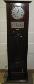 Federation University Historical Collection
Object, Synchronome Co. Ltd, Synchronome Frequency Checking Master Clock No. 2191, c1930
Information from Norman F. Dalton: Ballarat had a reticulated DC supply in the early part of last century and in 1905 had sufficient generating capacity to enable the trams to be changed from horse drawn to DC electricity. The use of electricity increased with the main power station located on Wendouree Parade, near Webster Street, under the ownership of The Electric Supply Company of Victoria. AC generating plant was installed in 1925 and conversion to AC proceeded. In 1934 the company was taken over by the State Electricity Commission Victoria (SECV) and more AC generation was installed and the changeover of customers was accelerated. This is around the time that the Synchronome Frequency Checking Mast Clock was installed at the Wendouree Parade Power Station. The SECV Annual Report of 1921 states: ::Section 11 of the act directed the COmmission to enquire into the question of securing the adoption of such standards of plant and equipment of a system, frequency and pressure for the generation and distribution of electricity as will admit of the efficient interconnection of undertakings throughout the State. In 1934 when the SECV took over the Ballarat operations the question of linking with the State grid had been a planned operation for some years but due to financial considerations had hindered it and in fact would continue to do so for a further 10 years. So while the need for close frequency control for interconnection was hardly an issue, the need to keep electric clocks correct was important, particularly as this item was a frequent sales point to cover the inconvenience and sometimes expense of converting from DC to AC. The clock is a very accurate pendulum clock with provision for varying effective length during operation for precise time regulation. There are two normal time dials and one is controlled by the pendulum and the other is operated by the system frequency. When the clock was in use it was installed by the MEter and Tests Laboratory and the time was checked daily by radio time signals. The two dials were repeated in the operators control panel in the Power Station. A maximum deviation between the two dials was set in the operating instructions (eg 5 seconds) and the operator would correct this when necessary by remote manual alteration of the turbine governor set point. The clock was used to drive and regulate a system of "slave" clocks which were used to display the time in various locations around the power station. A slave clock is a simple clock which is driven by a small electric motor, its accuracy is regulated by the master clock every 30 seconds to ensure that it and all the other slave clocks in the station are on exactly the right time; slave clocks were placed in various locations, from common rooms to workshops. A master clock could potentially run thousands of slave clocks at one plant. The clock also contains a rectifier. A rectifier is a device that is used to convert AC power to more stable DC current.Two clocks in a timber case. Both are electric, one is powered by the main pendulum mechanism, the other is a self contained electric clock. The main mechanism is of the gravity arm and roller type, which sends an impulse to the slave clocks every 30 seconds. The This Synchronome Frequency Checking Master Clock was used at the Ballarat Power Station. Below the main section of the case is a smaller cabinet containing a rectifier to provide consistent DC power for the clock. The rectifier was made by the Victorian company Hilco, which was located in Burwood. There is a high chance this is not the original rectifier from this clock as there appears to be brackets to hold a larger device in the space the rectifier occupies.Front below main clock face on front of case: "Patented Sychronome Brisbane" Lower left-hand clock face: "Frequency time" Lower right-hand clock face: "Standard Seconds" Synchronous electric clock mechanism on door (Frequency time clock): >200/250 V. 50~ >"Synchronomains" Made in England >Direction indicator for clock starting switch >"To start move lever in direction of arrow and release" >"Patent applied for" Mechanism for "standard seconds" clock: >"English Made" >"Patented" >Serial number "321" >0 above right-hand pillar on front-plate Mechanism for "standard seconds" clock: >"English Made" >"Patented" >Serial number "321" >0 above right-hand pillar on front-plate Mechanism for main clock face: >"English Made" >"Patented" >Serial number "8751" >0 above right-hand pillar on front-plate Inside case, back panel, top enamel plate: >Seconds Battery + Pos. > Battery Common or - Neg. >1/2 min dials Inside case, back panel, bottom enamel plate: external seconds dial Inside case, right hand side, electrical knobs: two switches, both "A.C. mains" Pendulum rod, below suspension spring: Serial number (?) 0000005 Rectifier in bottom cabinet: >"Hilco Rectifier" >"A.C. Volts 230/240" >"Model 1060/S" >"A.C. Amperes" >"Serial No. 1060/S >"Phases 1" >"D.C. Volts 6" >"C.P.S. 50" >"D.C. Amperes 1" >"Made in Australia by Hilco Transformers McIntyre St., Burwood, Victoria." Bakelite electrical plug: makers mark Lower cabinet, RH side panel, pressed tin plate: "AC" (upside down) Brass speed adjustment, outer right RH side: "S" and "F" Ivory and wood pendulum beat ruler: >Ruler, with 0 in centre and numbers 1-5 in ascending order from centre on left and right. > "Synchronome Patent." Steel plate, back panel, inside case, right hand side: >N R A" (descending) >"2191" serial number/part number Face of main clock: "Synchronome Electric" synchronome frequency checking master clock, electricity, state electricity commission, wendouree parade power station, secv, clock, time, pendulum, electric supply company of victoria, norman f. dalton, ballarat power station, rectifier, slave clock -
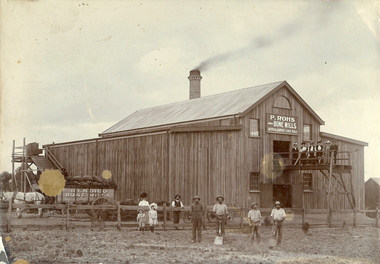 Bendigo Historical Society Inc.
Photograph - BENDIGO BONE MILLS, c1880
Sepia photograph on grey mount of P Rohs Bone Mills, artificial manures, flock mills. Timber building, with large brick chimney stack. Dray loaded with bags of manure pulled by white horse. Female and male figures on platform in front of building. Two children and group of five males and one female on ground. Inscriptions: in image - 'P Rohs, Bendigo Bone Mills, Artificial manures, flock mills'. On cart in image - 'Bendigo Bone Mills', On front TR corner 'MP115'. On back - 'Peter Rohs Fertilizer Factory, Rohs Road, Bendigo c1880'. Handwritten on back in ball point pen.buildings, commercial, p rohs bone mills -
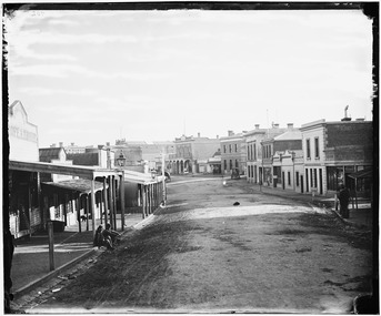 Stawell Historical Society Inc
Photograph, Main Street Reefs Stawell looking West from Layzell Street 1874 -- 2 Photos
Holtermann Photo 1874Main Street looking West from Layzell Street. On left Heide's European Hotel with Heide's two boys out front, David Nicholas Hotel. Foresters Hotel on corner of Patrick street, Fire damaged wall of Mechanics Institute. Top roofline of J. Allingham Drapers in distance. From right R.W. Dane Grocer on corner. Union Bank of Australia, Bennett & Bristow, A.B. Clemes, J. Punchard Furniture Mart, J. Punchard's Timber Yard. Oriental Bank, Bank of Victoria, D Telford Produce and Grocer, Chadwick & Co Drapers & Outfitters / London House, Stawell Auction Market Auctioneer.stawell -
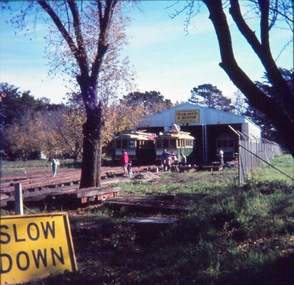 Ballarat Tramway Museum
Slide - 35mm slide/s - set of 8, John Theodore, 1972 - 1974
Yields information about depot activities of the BTPS in building the depot fan and access track.Set of 8 AGFA blue and white plastic mount 27mm sq slides of various works at the BTPS depot during 1972 / 1974. .1 - View looking from roadway showing depot, and various works at the depot - 26 and 27 out front. .2 - Sawing timber sleepers to length - Noel Forster, Barry McCandlish, Bill Kingsley .3 - Ballasting the access track - Rolf Jinks and Clyde Croft .4 - working on the roof of 27 - Geoff Cargeeg and others. .5 - break time. .6 - Bob Prentice and Geoff Cargeeg? on roof of 27 .7 - ditto .8 - Interior photo of 27Various notations by John as to the slide number and the trams in pencil and ink.tramways, trams, btps, depot, track construction, trolley poles, interiors, tram 26, tram 27 -
 Kew Historical Society Inc
Photograph - Cosy Five Roomed Rough Cast Bungalow, Kew, J E Barnes, c.1920
Subdivision plans are historically important documents used as evidence of the growth of suburbs in Australia. They frequently provide information about when the land was sold on which a built structure was subsequently constructed as well as evidence relating to surveyors and real estate and financial agents. The numerous subdivision plans in the Kew Historical Society's collection represent working documents, ranging from the initial sketches made in planning a subdivision to printed plans on which auctioneers or agents listed the prices for which individual lots were sold. In a number of cases, the reverse of a subdivision plan in the collection includes a photograph of a house that was also for sale by the agent. These photographs provide significant heritage information relating house design and decoration, fencing and household gardens. The photograph is also aesthetically significant as it was taken by J. E. Barnes, a nationally significant photographer. He was the most important photographer to have worked in Kew. He was active as a photographer in the district from c.1906 until his death in 1921. Best known as 'the Embarkation Photographer' (see the Australian War Memorial collection), Josiah Earl Barnes was also the official photographer employed by the Borough (and later Town, then City) of Kew. He clearly also completed commercial jobs for local businesses, as is the case in this photograph of a house for a local real estate and financial agent. A modest weatherboard house with rough-cast rendered walls. The gabled entrance incorporates elements of the Japanese aesthetic. The strong lines of the dark timber gable are reinforced by the colour and shape of the pickets in the fence. In contrast to an earlier period, the chimneys appear truncated. The use of extensive double-hung sash windows in the front rooms reflects a new interest in light in houses. The use of separate sunshades over windows in an earlier period is here replaced by an extension of the roofline over the window. The photographer Josiah Barnes died in 1921; so, the photograph of the house must predate this date. The location of the house, which was advertised for sale, has to date not been identified. Illegible inscription. Photographer's information on mount.josiah earl barnes, j e barnes, photography - kew, interwar housing - victoria, 1920s housing - kew -
 Surrey Hills Historical Society Collection
Photograph, Holy Trinity Church, Surrey Hills in the 1920s
This church was built in 1907 and became known as Holy Trinity Surrey Hills. This name had previously been used by the Anglican Church in Mont Albert Road, Mont Albert. This henceforth became known as St George's Anglican Church, Mont Albert. There are 2 copies: the original donated print and an enlargement. The original is mounted on card with photo mounts along with 890, 891 and 892. It measures 13 cm x 9 cm. Norman Carter took many photos of Surrey Hills and Mont Albert from the 1920s in particular of events and activities associated with the Church of England.Black and white photo of the original Holy Trinity Church building in Union Road. It is constructed of weatherboards, above which there is plasterboard and timber strapping. The roof is of terracotta tiles with a small steeple at the front and a larger one towards the rear of the building. There is a box bay window at the front and the entrance is from a porch on the southern side of the building. This is approached by stairs. Part of the vicarage can be seen on the northern high side of the church and to the south there is vacant land. The whole property sits behind a simple post and wire fence. There is a phaeton in the foreground beside a relatively newly planted street tree. The road has bluestone kerb and channelling.churches, holy trinity church, anglican church, horse-drawn vehicles, norman brodley carter, union road -
 Bendigo Historical Society Inc.
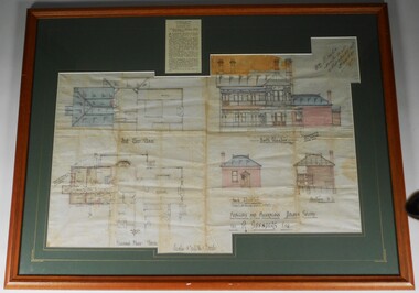
Plan - PLAN OF 'TINTEN GLEN' GOLDEN SQUARE BY WILLIAM BEEBE
Plan of additions and alterations to house in Golden Square, Bendigo. Plan mounted on green board and framed in brown timber and glass. Plan shows front and side elevations and floor plan. House, called 'Tinten Glen' was owned by R. Saunders Esq. R. Saunders owned a store in High Street, Golden Square.Additions and alterations designed by William Beebe, Architect, Bendigo. On paper on top RH side " Wm Beebe, Architect, Williamson Street, Bendigo'. Top centre of framed item has a newspaper cutting displayed, detailing the auction of the house on Saturday 6th. May ( no year ). Date 1905, confirmed on digital newspaper.bendigo, buildings, tinten glen, golden square, william beebe -
 Melbourne Tram Museum
Negative - Set of 2, Possibly Geoff Grant, c1950
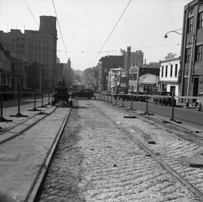
Set of two Black and white negatives of track construction in La Trobe St during 1950. .1 - Looking east from Queen St. Has the Argus building in the view. Both tracks have been constructed and the concrete foundation poured pending the top asphalt layer, a building selling Skoda cars, .2 - Looking west from Queen St with a tram crossing in the background in William St. Photo shoes the method of track construction - timber sleepers with the rail bolted to the sleeper. Pending concerting. In the background is The Mint and terrace houses on the left. There is a billboard for 1949 movie, "The Bribe". Photo not in Wal Jack Melbourne album.trams, tramways, la trobe st, track construction, trackwork, queen st -
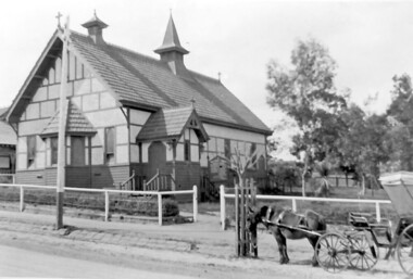
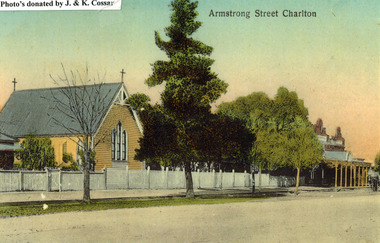 Charlton Golden Grains Museum Inc
Photograph, St Martin's Anglican Church, Armstrong St Charlton
St Martin's Anglican Church was built in 1889. Victoria Hall was built for E. Miles in 1884. The post card is part of a series taken c. 1907.Copy of a coloured (hand coloured?) post card showing St Martin's Anglican Church, Armstrong St, Charlton. The church is a yellow, timber building with a cross at each end of the roof. A white picket fence runs along the front of the church. There are three trees on the edge of the road in front of the church. There is a large single storey red brick building to the right of the church with a verandah over the footpath. A horse is coming down the road past the red brick building. The post card has Armstrong Street Charlton in the top right. There is a typed note in the top LH corner of the photo that says Photo's donated by J. & K. Cossar.pastoral care, st martin's, angllican, church, armstrong street, charlton -
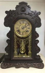 Mont De Lancey
Domestic object - Mantel Clock, The Ansonia Clock Co. Manufacturers USA, 1880's - 1920's
The mantel clock has a rich history that dates back to the 18th century. These smaller clocks were designed during an age when people wanted elegant timepieces that fit on mantels or shelves. Their compact size and decorative designs made them a popular choice for homes of the time. They graced the mantelpieces or tables in homes, serving as both functional timepieces and sophisticated decorations. These clocks often feature ornate wooden carvings and intricate designs, with their gentle ticking and chimes adding a cozy ambiance to living spaces. It is from the home of Mr and Mrs Parker. It belonged to Mr Parker senior.A very ornately carved dark timber mantel pendulum clock with a white face and a brass clock face surround. It has black roman numerals and black metal hands. The Ansonia Clock Co. Manufacturers USA Trademark A is printed on the face. It has an ornate brass pendulum and the internal workings are visible. The very ornately embossed in gold decorated glass front door opens. There are two spirit plumb levels inside, one is aluminium metal and is attached to the wall, the other is brass with Wm Hunt Level Co with a triangle on top stamped on it. There is a brass key No.7 with two holes on the top of the winder handle. The Ansonia Clock Co. Manufacturers USA Trademark A. printed on the dial. Wm Hunt Level Co. stamped on the level.mantel clocks, clocks, timepieces, shelf clocks -
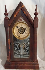 Mont De Lancey
Domestic object - Mantel Clock, 1880's - 1920's
The mantel clock has a rich history that dates back to the 18th century. These smaller clocks were designed during an age when people wanted elegant timepieces that fit on mantels or shelves. Their compact size and decorative designs made them a popular choice for homes of the time. They graced the mantelpieces or tables in homes, serving as both functional timepieces and sophisticated decorations. These clocks often feature ornate wooden carvings and intricate designs, with their gentle ticking and chimes adding a cozy ambiance to living spaces.A small vintage decoratively carved dark timber steeple mantel pendulum clock with a white cardboard face, black roman numerals and black metal hands. There is a brass trim around the face. The turned wooden frame at the front has has It is in working order. The very ornately white painted pattern on the glass door has a leaf and floral pattern. The door opens with a small decorative brass catch to reveal the inner workings. It has an ornate hanging brass pendulum and the internal workings are visible.There are two spirit plumb levels inside, one is aluminium metal and is attached to the wall. There is a brass key which does not wind the mechanism. clock keys, clock components, timepieces, clocks, mantel clocks -
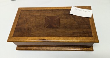 Alfred Hospital Nurses League - Nursing History Collection
Decorative object - Handmade wooden box with cross, c. 1920
Was presented to Mrs Lucie Hallenstein, honorary secretary of Alfred Hospital combine auxiliaries c. 1920. Mrs Hallenstein's Granddaughter Jane Helena Walters nee Shannon trainee of Alfred Hospital 1948-1951 presented the box to the nursing achieves with a hand written letter of explanation on 28/04/2011. Paper card insert is signed by Louisa Mann who was matron from 1912-1928.Item is significant as it was presented from Louisa Mann. Item also carries the Maltese cross from the Alfred hospital insignia. Has been presented to the archive from Alfred Hospital trainee. Handcrafted wooden box with parquetry Maltese cross in center. Box is made with multiple timber types and shades, is finished with a gloss finish. Two brass hinges allow the box to open. Hand written note on buff card paper with sticky tape holding item together enclosed within on small card from Louisa Mann stating "Affectionate Xmas greetings from Louisa Mann Alfred Hospital" Four rubber stoppers on base, eight screws visible on base holding wood together Black text marking on underside of box 392/02.3 White sticker with black ink marking 392/02+3[Affectionate Xmas/ greetings/ from/ Louisa Mann/ Alfred Hospital] [392/02.3] [392/02+3]alfred hospital, alfred nurses hospital league, ahnl, wooden box, handmade wood item, lousia mann, parquetry, handcrafted, timber box, maltese cross -
 Halls Gap & Grampians Historical Society
Map - Coloured
Background on Bridle Path up Stony Creek Gorge Pre 1840 C. B. Hall, squatter on Mokepilly Run 1841-1842, first European to discover the Fyans Creek valley, the entrance of which became known as Hall's Gap. He later recorded that he followed a number of tracks which he assumed had been made by the Aboriginies and described one as "leading up a wild romantic glen and over on to the source of the Glenelg River". This could well have been the route taken up Stony Creek gorge by the first timber-cutters in this part of the Grampians to the saddle between the Wonderland and Mt. Difficult ranges known as Valley Gap 1850s/60s Timber cutters and shingle splitters were reported to be moving into the eastern side of the Grampians and by the mid 1860s there were a number of families connected to the supplying of timber to Pleasant Creek living in the "Hall's Gap ranges". John Wakeham, the first store owner in Pleasant Creek in 1854, established a timer-mill in upper Stony Creek Gorge in the late 1850s. Wakeham is credited for the clearing and levelling of the first bridle-path up the gorge. 1870s By the mid 1870s the track had been extended over Valley Gap to the Victoria Forest (the upper region of the Victoria Valley). McKeon's bullock team was known to have hauled red gum from the Valley to Stawell in the late 1870s and the 1880s. 1880s In 1887 an article in the Pleasant Creek news describes the Stony Creek Gorge track as "being a ledge alongside the mountain range, formed in the early days with the aid of earth and timber, along which the bullock teams used to travel to Horsham and plains of the Wimmera beyond." 1890s Gold was discovered in the catchment area of Stony Creek and by the end of the 1890s a new track was built from "near the junction of Fyan's and Stony Creeks, up the gorge to the diggings settlement. The mining Department had paid L300 for its construction and, when completed, the track was "three miles and 30 chains in length, the side cuttings at the narrowest part being 10 feet between" and "the watercourses which cross the track at various points" having been "filled up with rocks rolled down the sides of the hills, and consequently there can be no damage caused by bushfires which destroyed the former wooden bridges erected on the old track to Wakeham's saw-mill, the remains of which are still to be seen at the side of the diggings" The article goes on to further describe the track as one which "can with ease travel with a two horse conveyance either up or down" and that the workmen engaged in the construction of the track would be attending "a ball that night at McKeon's farm near the mouth of the gap to celebrate the successful completion of the undertaking". 1900s At what time the bridle path was extended beyond Valley Gap to the Wartook basin on the Mt. Difficult Range has not yet been determined. However, it is known that, by the turn of the century, people were travelling between Halls Gap and the caretakers' residence at Wartook Reservoir along what was now known as the "Bluff Road. Wartook's embankment had been constructed in 1887 and at that time there was already a track from Rosebrook Station homestead (near the present day Wartook Pottery) to the reservoir. Philip Rose owned both Rosebrook and Wartook Stations from the mid 1840s to the late 1850s and had regularly leased the Wartook basin to Cobb & Co. to rest horses there. 1920s Following the war of 1914-1918, tourism really took off in the Grampians, and Halls Gap rapidly grew. People would travel as far as they could on the many tracks then hike to the many lookouts being discovered by local tour guides. This led to the need for access across the range so that horse riders and the increasing number of vehicles could travel between Horsham and Halls Gap. To this end, the Bluff Road was improved and extended on 1929 and at its opening in March, 1930, by Lady Somers it was renamed the Mt. Victory Road.Map of Mt Victory Road and othersaccess routes, mt victory rd, bridle path, roads -
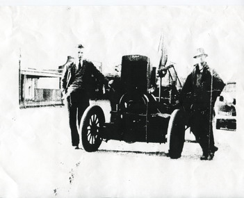 The Beechworth Burke Museum
Photograph, 1936
This automotive circular saw was designed to allow trees to be sawn into planks at the site they were felled, rather than requiring them to be carted to a lumber mill first. It was invented by Robert John (Bob) Pyle in 1936 and patented in 1937 (serial number 101975). This picture depicts Clarrie Howell (left) and Bob Pyle (right), standing with the sawbench between them. What was special about Bob’s new invention was that it not only allowed a circular saw to be portable and set up at a logging site, but that it allowed the circular saw to be run using the car motor, and that the saw could be detached, allowing the car to be used for carting or other purposes. This photograph is significant because it shows an early instance of an emerging technology, portable sawmills, and is evidence to the innovations that the people of Beechworth have achieved throughout history, as well Black and White rectangular photograph printed on matte photographic paper. Incription on cream paper stapled to bottom left of photographObverse: On left Clarrie Howell / Right Bob Pyle / with sawbench built by Bob Pyle / Patent 1936 / Rosalie Pyle has the original / [redacted]bob pyle, robert pyle, r j pyle, clarrie howell, howell, pyle, invention, patent, sawmill, saw, sawbench, wood, timber, forestry, automobile, car, 1930s, 1930s beechworth, industry, wooden, convenience, innovation -
 Federation University Historical Collection
Booklet, Little Desert National Park and Wail State Forest Proposed Management Plan, 1991, 11/1991
Grey soft covered report of 80 pages. Includes a pull out map.little desert national park, wait state forest, management plan, horsham, department of conservation and environment, rod gowans, don spence, wimmera river, threatened plants, fauna, flora, birds, mammals, wergaia, scarred trees, mounds, pest plants, pest animals, tourism and recreation, timber, grazing, conservation -
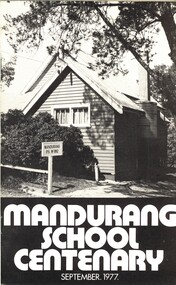 Bendigo Historical Society Inc.
Book - MANDURANG SCHOOL CENTENARY SEPTEMBER 1977, c1977
Mandurang School Centenary, September 1977. Espress Print, Bendigo. 24 pages. Photographs and illustrations. With IndexMr G Pearce, Mr J Sloan, Mr K O'Brien, Mrs, J Frenchschool, centenary, mandurang, history of mandurang state school and district, industries, wine, milk, gold, tannery, look-out, timber, hotels, water race, floods, post office, sports, churches, fire brigade, school opens 1877, head teachers, mothers club, education -
 Kiewa Valley Historical Society
Photos - King Family Collection
The King family lived in Tawonga South where my older brother and sister went to school. We lived over the road from Wally Madison's farm. Later when a house became available, we moved into Valley Avenue, Mt Beauty. This is when I turned 5 and started my schooling. It was a long walk for a 5 year old as I remember. Then later we moved to 50 Lakeside Ave. I remember we loved living there as it was close to the school, footy ground and kindergarten. My father, Ted King, wad a carpenter and was involved in the building of many houses in Mt Beauty which was the home for the workers on the Kiewa Electric Scheme. So as they are part of the history of Mt Beauty I thought they may be useful to you as part of the history. The tennis photos, I vaguely remember Lou Hoad and Ken Rosewell giving exhibition matches in Mt Beauty. I may stand corrected on this, but I do remember my parents who were keen tennis players themselves were most excited at seeing these famous tennis players. As I was only 9 when we left Mt Beauty to live in Dimboola I still remember the shock of leaving a beautiful mountainous county side and arriving in a flat farming land next to a desert and seeing windmills One thing I do remember from school is, once a week (or fortnight) the teacher used to come around with a jar of little white pills, of which we were all to take. I really don't know what they were?? or for?? I also remember being taught to swim in the freezing cold river by a Mrs Smith who wore black bathers and wore her hair in a bun...... ...I am now in my 70s My father used to also carve intricate trays and jewellery boxes in his spare time. I think they were used for tennis trophies. by Diane Werner.x33 photos of small black and white photos of the Tawonga, Tawonga South and Mt Beauty - Photos not labelled but described as follows. See each photo for a possible label. A. Tawonga? B. Mt Beauty taken on the road to Bogong ? C. SEC Works D. Industrial buildings with mountains in the background E. Building site with wooden frame and 3 men F. Buildings with power poles G. Building site with lots of huts H. Buildings under construction I. Group of houses in the distance J. Group of houses in the distance K. Group of people in front of a building L. Group of 8 men sitting on timber planks, corrugated iron at back. M.& N. Building site with floor and upright timbers O. Mountain view with camp site in foreground P.& Q. Buiding site, several houses R.5 men at a building site S. portable building on trailer T & U. Mountain view V. Building site W. Group of men, car and mountains in background X. Cows Y. Pigs Z. 2 men standing next to cars. AA. Football players BB. Man painting a corrugated iron building CC. Football DD. Men in front of a building EE Buildings with mountains in background FF & GG Tennis payersHH & II. Electricity infrastructure -
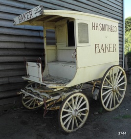 Flagstaff Hill Maritime Museum and Village
Vehicle - Wagon, H.H. Smith & Co. Baker, Circa 1930s - 1940s
This baker’s wagon or cart transported and delivered bread and other baked goods in the Warrnambool area. It currently has advertising for H.H. Smith & Co. Henry Huntington Smith (1857-1941) owned and operated his Warrnambool bakery in the late 19th and early 20th century. However, the design of the wagon is similar to those used by local bakers in the 1930s and 1940s and probably originated from Stephenson’s Bakery in Warrnambool, which operated around that time. The wagon’s original internal shelves were removed in the early days of Flagstaff Hill so that children could have rides around the village in a horse-driven cart. BAKERS’ HISTORY There were many bakeries in Warrnambool in the 19th to mid-20th century. Each bread bakery made horse and cart deliveries in its allocated zone. SMITH’S BAKERY; – as shown on the wagon’s signage. Henry Huntington Smith (1857-1941) was born and educated in Warrnambool. He worked at Davis’ steam biscuit factory in Timor Street before he began his own bakery business in 1885 near the corner of Fairy and Koroit Streets. A few years later Smith built a new bakery on the corner of Fairy and Lava Street where it still stands today (2025) as Monaghan’s Pharmacy. The building was designed by James McLeod in 1892 as a bakehouse, shop and residence for Smith The address was known locally as Smith’s Corner. Next door to the bakery, at 136 Fairy Street, were stables built by Jobbins and McLeod in 1886 for William Cust. A photograph in the archives of the Warrnambool and District Historical Society shows the 1892 building with four fancy horse-drawn wagons on the street with white-clad drivers and a promotional stand erected with 5 bakers in uniform and the signage “H H Smith & Co, Pastry Cooks and Confectioners”. One of the wagons appears to have “H H Smith” painted on the side. H.H. Smith & Co. placed an Advertisement in the Weekly Times in December 1896 promoting its business as bakers, confectioners and pastry cooks, praising their shop as an ‘ornament to the town’ with ‘neat appointments’ and ‘dainty decorations’. It also boasted of supplying a large number of customers within a twelve-mile radius of Warrnambool. In November 1919 The Warrnambool Standard announced the marriage of Henry H Smith, Mayor of Warrnambool, to Jeannie Samson-Goodman in East Adelaide. In the same newspaper was a notice that Frank Crossley was to open as baker and pastry cook in H.H. Smith’s premises. As well as being the proprietor of the H.H. Smith Bakery, Henry Huntington Smith was a Councillor for the Warrnambool Municipality from 1913 to 1937 and Mayer for two terms. In December 1919 during his first term as Mayor, he was honoured for the work he had done with returning soldiers after World War I, receiving a document in recognition of this work, presented by the Mothers, Wives and Sisters of returned soldiers. Smith was very interested and involved in the community in many roles, including being the Vice President of the first Warrnambool and District Historical Society. STEPHENSON’S BAKERY: – believed to be the past owner of the wagon. The last owner of the bakery was Harold Stephenson. Stephenson was enlisted in the A.I.F. and was invalided home in 1943 before the end of the Second World War. He also served as a Councillor from 1958 to 1976, during which time he served six terms as Mayor for the City of Warrnambool (1966-1973) while he had the bakery. He was very involved in many local organisations including the Warrnambool Surf Life Saving Club and the Road Race Committee. He died in 1985, lauded as being one of Warrnambool’s “most distinguished civic leaders”. It has been said that the baker injured in World War II invented a special contraption to enable him to get up into the wagon and that he alerted his customers that he was in their vicinity by blowing a whistle. The customers would come out and choose their bread from the back of his wagon then pay him for it. However, another account is given by a man who once earned pocket money by helping the baker on his rounds. He says that it was Stephenson, the owner and manager of the bakery, and not the delivery baker who received a significant injury during the war, making him unable to climb the stairs of his upstairs accommodation at the bakery, therefore causing him to sleep downstairs. At this time in the early to late 1940 Stephenson’s bakery had three wagons, one for each of the delivery rounds. The wagons were painted black and yellow. Two of the drivers were Stan Lake and Ali (Alec) Dean who both had wagons with the covered cabin design. The third driver was Bill Lake who had a flat wagon. Stan Lake delivered in the area around Lava and Koroit Streets, Ali Dean had another round and Bill Lake had the Dennington area. Bread continued to be delivered into the 1960s but by this time the delivery vehicles were motorised. The goods produced at Stephenson’s bakery included bread baked in different shaped tins such as High Tin, Sandwich and Vienna. Some shapes were easily divided into half by breaking them apart, therefore the baker could make two-quarter loaves from a half loaf, satisfying different needs. There was the option of white or brown bread, sweet buns, fruit buns and Boston buns. The baker’s assistant was known to take great delight in ‘trimming’ the broken halves of excess bread and crust, enjoying his treat. THE BAKERY PREMISES: – Southeast corner of Fairy and Lava Streets, Warrnambool. The building retains the original cast iron veranda. Above the veranda, a motif of a wheat sheaf in ornamental plaster can be seen. Inside the building, there are still some of the original fittings. The building was classified by the National Trust in August 1979. After the Second World War, an official system of zoning was introduced as a fair way for the baking industry to operate. In 1949 different pricing was introduced by the Government for either delivered or retail purchased bread. Many of the small local bakeries went out of business after the Government banned zoning. The way was made open for the larger bread manufacturers to enter the local market with cheaper prices. Some of those companies were Mc Queens, Tip Top, Twisties, and Sunicrust, (Mc Queens ‘new’ bakery building was where the current Toyworld shop now stands, is, in the Ozone carpark.) O’Grady’s Bakery, later changing hands and known as Burkes Bakery, was on Fairy Street near the Timor Street intersection, on the North West side. There was also a bakery named Almay. The baker’s wagon is significant because of its association with H.H. Smith’s Bakery in Warrnambool.. The H.H. Smith’s Bakery building on the corner of Fairy and Lava Streets, built in 1892, is classified by the National Trust, August 1979. Smith Street Warrnambool was named after Henry Huntington Smith, who was a Warrnambool Councillor 1913 – 1937 and Mayor 1919 – 1921. Baker’s wagon, often referred to as a baker’s cart. Four wheeled horse-drawn delivery wagon, front wheels smaller than rear wheels. Wagon is clad with metal sheets and lined with varnished timber panels. Wheels have metal rims, wooden spokes and rear wheels have wooden brake pads. Horse shaft is timber with metal fittings. Front has a metal lamp holder, brake lever, metal hand grips and decorative metal foot plates. The wagon has suspension leaves on back and sides and double suspension leaves on the front. Driver’s area at front has a roof, glass side windows and wooden box seat with hinged compartment accessing wagon storage area. Door above back of seat has buckled leather handgrip strap attached, door slides open for access to wagon area. Back of wagon has a wooden step and a split door; top door has ventilation louvers, both doors have metal latches. Wagon is painted cream with brown trim and signage and green step. Remnants of red and green paint are visible; underside of seat panel is painted grey. Wagon advertises H.H. Smith & Co. Baker, a Warrnambool business established in 1885, but is of a more modern design seen around 1930’s and 1940’s and most likely belonging to Stephenson's bakery. Brown signwriting on sides of wagon “H.R. SMITH & CO. / BAKER” Brown signwriting across front of wagon “BAKER” warrnambool, shipwrecked-coast, flagstaff-hill, flagstaff-hill-maritime-museum, maritime-museum, shipwreck-coast, flagstaff-hill-maritime-village, shipwrecked-artefact, great ocean road, baker’s wagon, h.h. smith baker, warrnambool, henry h smith, jeannie samson-goodman, frank crossley, mayor of city of warrnambool, vice president of warrnambool and district historical society, stephenson’s bakery warrnambool, harold stephenson, warrnambool surf life saving club, road race committee, national trust building, stan lake, bill lake, ali dean, 19th and 20th century bakers, davies steam biscuit factory warrnambool, james mcleod building designer, jobbins and mcleod, william cust, h h smith & co, pastry cooks and confectioners, bakery trade, bread delivery wagon -
 Eltham District Historical Society Inc
Photograph, Hurstbridge shops, Heidelberg-Kinglake Road, opposite Hurstbridge Railway Station, Eltham Heritage Tour, 24 May 1992, 24/05/1992
ELTHAM HERITAGE TOUR The Society excursion on 24th May 1992 was arranged by David Bick, leader of the team carrying out the Shire's heritage study. David selected a number of sites or buildings identified in the study, some of them lesser known components of the Shire's heritage. The tour commenced at the Eltham Shire Office at 10.00 am. Travel was by private car and mini-bus with stops at about twelve locations for commentary by David.It included a short walk in Hurstbridge and lunch at Kinglake. Highlights of the tour included: - 10 am Leave from Shire Offices - 3 Important Trees - A Physical Link to Eltham's First Settlers - Toorak Mansion Gates - A Surviving Farm House - An Intact Circa 1900 Main Street - First Settlers - Gold Miners, and Timber-getters - An Early Hotel - A Pioneering Homestead - Changing Eltham Shire - 20th Century - 4 pm Afternoon Tea and Finish Tour Extract from ELTHAM CULTURAL HERITAGE TOUR (Newsletter No. 85, July 1992, by Bettina Woodburn) "Leaving the cars at Hurstbridge we walked the main street of the old village settlement, now a suburb. Near the station was a fine Edwardian house complete with palm and pines. Opposite was the Police Station, 1930-60 with a portable lock-up behind and the residence beside it. No. 794 was the Post Off1ce 3099 the-original shop-front window now has mail-boxes below. Close to the Railway entrance the butcher's shop remains unchanged, but across the road the linear shopping centre tries to keep the character of the olden times. The Fire Bell once hung on a tall gum outside No. 832. Palms in front gardens indicate the age of some of the homes, about 70 years. A corrugated iron shed still stands on the front fence line next to No. 840. Adding to the streetscape is an example of the standard timber early 20th century four veranda post suburban villa."Record of the Society's history and activities and highlighting various aspects of the Heritage Study undertaken by David Bick used to create the future heritage overlay for the Shire of Eltham and later Nillumbik Shire.Roll of 35mm colour negative film, 4 stripsKodak Gold 100 5095shire of eltham historical society, activities, heritage tour, hurstbridge, shops -
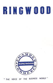 Ringwood and District Historical Society
Document, Packet: Ringwood Chamber of Commerce & Whitehorse Traders - Early correspondence (1930's) and Clippings etc. 1950s-1990s
Miscellaneous documents relating to the Ringwood Chamber of Commerce and Whitehorse Traders.Packet includes: . Correspondence to Council re Ringwood Xmas Carnivals in the 1930's. . Hand written minutes of meetings of Ringwood Traders- c1930's. . Miiscellaneous newspaper clippings relating to Ringwood Traders- 1909 to 1990's. . Plan of proposed 'Fat Boiling Down Room' for Mr G. Pratt, butcher in Junction Rd Ringwood. c1937. . Description and rough sketch of proposed building for "My Ease (Vict.) Pty. Ltd." as factory for Manufacturing Worcestershire Sauce. c1929. . Price list for H. J. Bently, Timber Merchant, Ringwood, dated June 1917. . Literature compiled by the Ringwood Chamber of Commerce advertising Ringwood as a business centre. -
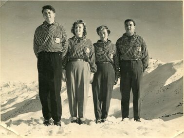 Kiewa Valley Historical Society
Photographs – Skippy St Elmo and other skiers – Set of 8 black and white photographs
Skippy and Toni St Elmo were responsible for early developments at the Falls Creek resort and for promoting a love of skiing. They left Melbourne in 1945 and settled at Falls Creek and moved into the first building constructed of corrugated iron and timber at Falls Creek in 1946. They were Falls Creek’s first workers with Toni employed by the State Electricity Commission to record weather-related data up to the construction of the Kiewa Hydro-Electric Scheme. In 1957, Toni was involved in building the first rope tow called Nissen on the same route as the Summit Quad. He also established the Nissen Ski School with ski instructor Milan Kovacic and was involved in the building of the resort’s first ski club Bogong in 1949. Toni taught Skippy to ski and she practised on the High Plains where she and her husband lived. Skippy St Elmo won many ski races during the 1950’s and represented Australia in New Zealand.Skippy and Toni St Elmo were pioneers of the Falls Creek area, promoting local ski sports and tourism. The played an important role in opening up the Falls Creek area and developing its sporting potential by establishing the first ski school, ski lifts and early lodge facilities. Skippy and Toni St Elmo were honoured at the Alpine Village at Falls Creek on November 17 2006, with the spreading of their ashes at the place which played such an important part in both their lives.Set of 8 black and white photographs of Skippy St Elmo and other skiers 1. Skippy and 3 others in New Zealand 1951 2. Skippy and 5 others Falls Creek 1955 3. Cake celebrating 20 years of sport at Nissen Lodge 4. Skippy and friend outside Nissen Lodge 5. Skippy on the ski slopes 6. Skippy on the ski slopes 7. Albury Ski Club team New Zwealand 1957 8. The Bogong Ski Club 1950 Written on back of photos 1. Bob Howe Albury, Skippy New Zealand 1951 – 942H 2. Falls Creek 1955. Skippy St Elmo: H Devonassore; Margaret ?; ?; Tony St Elmo; Olive? 3. Written on cake Nissen Alpine Club. 20 years of sport. FRED 4. Skippy St Elmo 5. Skippy 6. Skippy 7. Bob Howe (Albury) Skippy New Zealand 1957. Albury Ski Club Team raced in NZ 8. The Bogong Ski club, Coronet Park, 1950. M Denham (Capt); B Wiltshire; R Roberts; Skippy St Elmo; Gwen Morris; J Frazer; J Smith; L Piera; Manager & Coach Toni St Elmo. J D Knowles Photographer Box 188, Queenstown. 744B falls creek, skiing, bogong high plains