Showing 7090 items matching "snowy-river"
-
 Queen Victoria Women's Centre
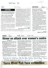
Newspaper excerpt, There's still a lot of life left in Women's Trust, State Govt position on Queen Vic Centre, and Kirner on attack over women's centre, 8 October 1997
A4 page of complied print media about financial troubles and a possible closure of the QVWC. Possibly from all from Melbourne times.Marking in blue pen ink o dates and page numbers. at the bottom there is a cut out o a newspaper headline reading Yarra River fish face extinction and the inscription above reads "And now the Melb Times has the ish facing 'final days'. Seems to be the Melb Times spin on everything" correspondence, historic building, business and finance -
 Orbost & District Historical Society
coloured photographs, Hogeman, Trudi, 2000 - 2010
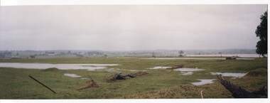
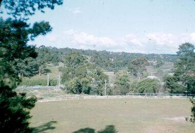
These photographs are of floodwaters on the river flats of Orbost, near Gilberts Gulch on the Marlo Road showing large lumps of wood in the middle of the road and a red vehicle in the background. 3090.4 has been taken looking down onto theSnowy Rive from near Mitchells / Griebenows Road Newmerella.This is a pictorial record of a significant flood event in Orbost.Four panoramic colour photographs showing the aftermath of a flood. flood-orbost-2000s -
 Greensborough Historical Society
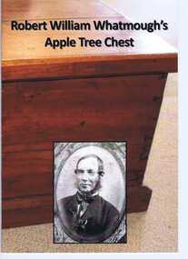
Book, Robert William Whatmough's Apple Tree Chest, 1878o
A brief history of Robert Whatmough's apple tree chest as inscribed on paper and attached to inside lid of chest. Contains photographs of the chest and articles about the owners and makers. This chest was made from the trunk of an apple tree washed down the Plenty River to Greensborough in 1878. [Published c2012]Published by a descendent of the Whatmough family with access to several family artefacts.20 pages, colour and black and white illus.robert william whatmough, steve whatmough sarah wilson, apple tree chest, plenty river -
 Glenelg Shire Council Cultural Collection
Photograph - Photograph - Martin Bree, 1910-1930
Photographs taken by Esther Winifred Hall (nee Smallpage) - great grand-daughter of Stephen George Henty. Taken in 1934 Centenary Celebrations in Portland. Donated by Ms. Mary Robinson, acting on behalf of Mrs. W.G. Hutchinson "Tellong", Blackwood River Drive, Balingup, W.A. 6253Black and white photograph showing a man and a dog in front of a paling fence. Man is holding gun to his shoulder in preparation to fire and dog sits to his right looking at the gun.Front: (no inscriptions) Back: Martin Bree -
 Greensborough Historical Society
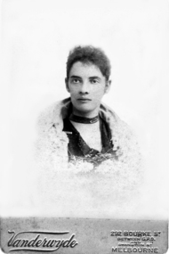
Photograph - Digital image, Emily A T Maygar, 1897c
A member of the Maygar family who came to Greensborough circa 1841 from Somerset England. They were of Hungarian descent. The family farmed along the Plenty River. [In The Melbourne Punch of 27/05/1897 the Vanderwyde Photo Studio Bourke Street featured and promoted their 'Head Study' photography.]Digital copy of black and white studio photograph.maygar family, emily maygar -
 Greensborough Historical Society
Article, Book, Heritage Publications, Greensborough history 1835, 1835o
Transcription of part of 'A History of the Colony of Victoria' Vol.1 1797-1854; by Henry Gyles Turner; 1904; reprinted 1973. A reference from the Diary of D. Medhurst refers to the probability of John Batman signing the treaty with indigenous inhabitants of the Melbourne area on the banks of the Plenty River at Greensborough.Typescript, 6p.plenty river, john batman, aborigines - banyule -
![Photograph - Digital image, Rand Street Bridge [Greensborough], 02/05/2013](/media/collectors/4f729f5697f83e03086015b8/items/572af0f12162f118342f250e/item-media/572af1252162f118342f2a1f/item-fit-380x285.jpg) Greensborough Historical Society
Greensborough Historical SocietyPhotograph - Digital image, Rand Street Bridge [Greensborough], 02/05/2013
These photographs of the Rand Street Bridge were taken in 2013 to show changes over 40 years, based on Ron Reynold’s sketches in the 1973 publication “Greensborough and Greenhills” published by Cypress Books. This is a pedestrian swing bridge over the Plenty River between Rand Street and Greensborough Station.Digital copy of colour photograph.greensborough and greenhills, rand street bridge, rand street greensborough, ron reynolds -
 Greensborough Historical Society
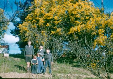
Photograph - Digital Image, Blackjack: five boys in the garden, wattle flowering, 1953_
Five boys in the garden at Blackjack, the home of the Robinson family to late 1956. The Blackjack property, house and acres of fruit orchards ran down to the Plenty River off Hume Street Greensborough. The photographs were taken as slides by Frank Robinson and digitised by his son James in 2015.Digital copy of colour photograph.blackjack, hume street greensborough, robinson family, frank robinson -
 Greensborough Historical Society
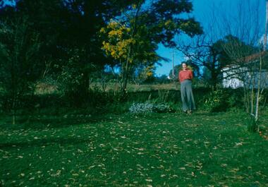
Photograph - Digital Image, Blackjack: Beb standing in the garden, 1953_
Beb standing in the garden at Blackjack, the home of the Robinson family to late 1956. The Blackjack property, house and acres of fruit orchards ran down to the Plenty River off Hume Street Greensborough. The photographs were taken as slides by Frank Robinson and digitised by his son James in 2015.Digital copy of colour photograph.robinson family, blackjack, hume street greensborough -
 Greensborough Historical Society
Photograph - Digital image, Frank Robinson, Greensborough Football Ground, 1956_
The Greensborough football ground 1956. The Blackjack property, house and acres of fruit orchards ran down to the Plenty River off Hume Street Greensborough and was the home of the Robinson family to late 1956. The photographs were taken as slides by Frank Robinson and digitised by his son James in 2015.Digital copy of colour photograph.frank robinson, greensborough football club -
 Greensborough Historical Society
Photograph - Digital Image, Blackjack from the north west, 1954_
Blackjack from the north west. The Blackjack property, house and acres of fruit orchards ran down to the Plenty River off Hume Street Greensborough and was the home of the Robinson family to late 1956. The photographs were taken as slides by Frank Robinson and digitised by his son James in 2015.Digital copy of colour photograph.blackjack, robinson family -
 Greensborough Historical Society
Photograph - Digital Image, View of Greensborough near Blackjack, 1954_
View of Greensborough near Blackjack. The Blackjack property, house and acres of fruit orchards ran down to the Plenty River off Hume Street Greensborough and was the home of the Robinson family to late 1956. The photographs were taken as slides by Frank Robinson and digitised by his son James in 2015.Digital copy of colour photograph.robinson family, blackjack -
 Greensborough Historical Society
Photograph - Digital Image, View of Blackjack near Greensborough, 1954_
View of Blackjack near Greensborough. The Blackjack property, house and acres of fruit orchards ran down to the Plenty River off Hume Street Greensborough and was the home of the Robinson family to late 1956. The photographs were taken as slides by Frank Robinson and digitised by his son James in 2015.Digital copy of colour photograph.robinson family, blackjack -
 Glenelg Shire Council Cultural Collection
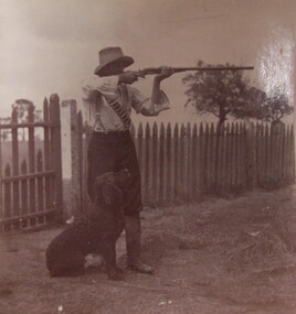
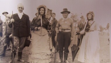
Photograph - Photograph - Portland Centenary, 1934, Esther Winifred Hill (Nee Smallpage), 1934
Photographs taken by Esther Winifred Hall (nee Smallpage) - great grand-daughter of Stephen George Henty. Taken in 1934 Centenary Celebrations in Portland. Donated by Ms. Mary Robinson, acting on behalf of Mrs. W.G. Hutchinson "Tellong", Blackwood River Drive, Balingup, W.A. 6253Black and white photograph of people in C19 clothing. In foreground, 2 men and 2 women are posed in a line. The men are carrying shotguns, the women are holding parasols - one open, one closed. Women are wearing bonnets and man on right wears a dark hat.Front: (no inscriptions) Back: (no inscriptions) -
 Eltham District Historical Society Inc
Book, Koorie Heritage Trust, Koorie, 1991c
Oldest culture - Yarra River and Port Phillip - Religion - Serpents - Fire - In 1830 - First contacts - Massacre map - Survival - Identity - Resistance and rights (Pastor Sir Douglas Nicholls) - Land rights - From hand-out to hand-back - Aborigines in war - Sportspeople - Cultural heritage.Paperback; 57, [3] pages : illustrations, maps, ports ; 30 cm.ISBN 0724198105aborigines, social customs, koorie, victoria -
 Sunbury Family History and Heritage Society Inc.
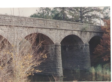
Photograph, Bulla Bridge, c 1980s
The bridge in the photograph is the bluestone bridge at Bulla which spans the Deep Creek, a tributary of the Maribyrnong River. It was built in 1869 and replaced a ford crossing which was built further downstream. Many of the buildings and structures in the area were built from bluestone which is in abundance throughout this volcanic area.This bridge is one of many similar structures built across Western Victoria where the bluestone volcanic rock was found in abundance.A coloured close - up photograph of a four-arched blue stone bridge spanning a waterway. Some greenery is visible on either side of the bridge and above it. bulla bridge, bluestone, bridges, deep creek. -
 Federation University Art Collection
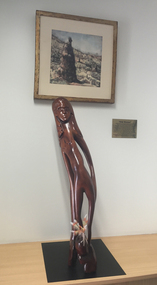
Sculpture - Artwork - Sculpture, Badger Bates, "Gitji Woman' by Badger Bates
William Brian (Badger) BATES (1947- ) Born Wilcannia Barkantji Badger Bates is a Barkantji Elder, political activist and contemporary artist. Known primarily for printmaking, wood and stone carving, his work is intrinsically linked to his lifelong fight for the safety and health of the Barka (the Darling River).'Gitji Woman' is carved from a very old piece of log found at Wittabrinna Creek near Tibooburra, Western New South Wales. The tree was dead for 60-80 years, and was hollow inside. "I could see a figure in the wood so I folowed the shapes already three. The woman has a drawn out figure with long fingers and is coming out of the log, she is an ancestral spirit. I put the pink cockatoo and emu feathers in the leg in the way people used to decorate themselves for corroborees."badger bates, paakantyi, wilcannia, timber, aboriginal, barkantji -
 Wonga Park Community Cottage History Group
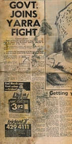
Newspaper (Item) - Cutting, Wonga Park: Herald newspaper cutting 16/9/1972 Govt Joins Yarra Fight
State Government agencies have joined local government to oppose lan developers' plans to subdivide an untouched pat of the Yarra. The subdivision involves 565 hectares (Yarra Brae and Stane Brae) and more than 16 kms of bush river frontage at Wonga Park in Lillydale Shire -
 Linton and District Historical Society Inc
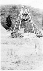
Photograph, Gold Mine at Devil's Kitchen, Piggoreet
Looking south into Devil's Kitchen, Piggoreet with the Woady Yallock River dry bed. This photograph was originally thought to be of the Try Again Mine, however information from Joan Hunt in 2015 suggests this is the Port Arthur No. 1 Mine, located between the Devil's Kitchen and the Grand Trunk MineSmall black and white original photograph of dry creek bed with mine poppet head in distance."1920s-1930s/Devils Kitchen/Piggoreet".try again mine, port arthur no. 1 mine, devil's kitchen, piggoreet, mining, mines -
 Flagstaff Hill Maritime Museum and Village
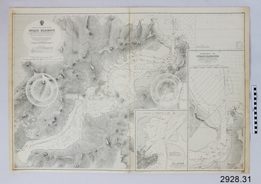
Document - Navigation Chart, British Admiralty, Otago Harbour, Late 19th to Early 20th century
Navigation charts are used by mariners around the world for navigating waterways. This chart was created for Otago Harbour in New Zealand. A ship "Otago' was named after this harbour and was once commanded by renowned maritime author Joseph Conrad. That ship now lies in Otago Bay, in the Derwent River, Tasmania.This navigation chart was published by the British Admiralty cartographer, to aid mariners to navigate the world's water bodies. Navigation charts are still used today, along with other navigational instruments.British Admiralty Navigation Chart - Otago Harbour, South Island, New Zealand. Chart shows insets with finer detail of important sections.warrnambool, shipwrecked-coast, flagstaff-hill, flagstaff-hill-maritime-museum, maritime-museum, shipwreck-coast, flagstaff-hill-maritime-village, shipwrecked-artefact, british admiralty navigation chart, navigation chart, british admiralty, otago harbour, south island, new zealand, otago bay, derwent river, tasmania, joseph conrad -
 Kew Historical Society Inc
Photograph, J F C Farquhar, The Yarra in Hyde Park, 1891
At the beginning of the 1890s, the Kew businessman and Town Councillor, Henry Kellett, commissioned J.F.C. Farquhar to photograph scenes of Kew. These scenes included panoramas as well as pastoral scenes. The resulting set of twelve photographs was assembled in an album, Kew Where We Live, from which customers could select images for purchase.The preamble to the album describes that the photographs used the ‘argentic bromide’ process, now more commonly known as the gelatine silver process. This form of dry plate photography allowed for the negatives to be kept for weeks before processing, hence its value in landscape photography. The resulting images were considered to be finely grained and everlasting. Evidence of the success of Henry Kellett’s venture can be seen today, in that some of the photographs are held in national collections.It is believed that the Kew Historical Society’s copy of the Kellett album is unique and that the photographs in the book were the first copies taken from the original plates. It is the first and most important series of images produced about Kew. The individual images have proved essential in identifying buildings and places of heritage value in the district.Hyde Park is now a small recreation reserve bordered by Willsmere and Kilby Roads and White Avenue. In 1982, Hyde Park was cut off from the Yarra River by the construction of the Eastern Freeway. The building of the latter was to transform the natural landscape, including the Yarra, as well as Hyde Park. The construction of the Freeway makes it difficult to view the scene with the photographer’s eye. Today’s Hyde Park is located on land purchased in 1847 by John Cowell, and in 1851 Catherine Cowell, yet the scene selected by the photographer may well have been located on farmland owned by the Wills family. Farquhar’s point-of-view emphasises both the pastoral and recreational elements of the scene: the grazing cows, three boys, and in the distance two figures, seated on the bank with a parasol. By 1891, an environmental consequence of human activity, including farming, was deforestation, leading to the erosion of the south bank of the Yarra. In contrast, the land on the Alphington side of the river in 1891 included remnant bushland.The Yarra in Hyde Parkkew illustrated, kew where we live, photographic books, henry kellett, yarra river -
 Mission to Seafarers Victoria
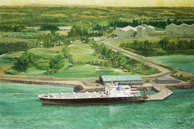
Painting - Painting, Acrylic, Ramon Honisett, Untitled, 1990-2000
Ramon (Ray) Francis Honisett (11.04.1931 - 30.08.2019), Fellow RMIT and medallist specialised in philatelic design, marine and military aircraft painting art and was active in the 1960s - 1990s. Ray Honisett used to live in Rye, in the Mornington Peninsula. According to Gavin Fry's book: The painting likely depicts the Lysaght Endeavour loading at Hastings. "The Lysaght Endeavour and its sister ship Lysaght Entreprise were built in Newcastle in 1973 specifically to serve the regional steel industry on the route Port Kembla - Westernport - Adelaide. Even after being lengthened by 17 metres, the two ships had remarkably short working lines, with both being broken up by 1988."Maritime artLarge framed unglazed landscape format painting predominantly green depicting in foreground a merchant vessel, a roll-on roll-off cargo ship moored at a single quayside on a river or river mouth. The middle ground shows a moderate solid jetty leading to large storage sheds at right. The background appears primarily rural with fields and hills in the distance. The location is probably Hastings Western Port in Victoria - notice the forklifts loading rolls of steel produced at the nearby steel rolling mill - the buildings in the distance. You can see the rolls of steel lined up on the hard stand to the right of the ship. The funnel colours suggest the Australian National Line. The frame incorporates a beige fabric slip with gilt edge the actual dark wood frame also with inset banded gilt edge. The back of the painting is covered with brown paper in places damaged. Hangs on a cotton cord threaded between two screw in eyelet hooks.at lower right corner single uc word in black paint : "HONISETT"tankers, marine painting, maritime art, ramon honisett, ray honisett, anl maritime art prize, acta maritime art prize, hastings, western port, victoria, steel, roll on roll off, forklift, mornington peninsula, artwork-paintings -
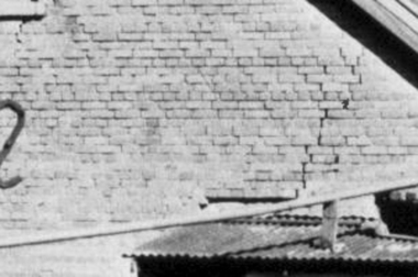 Greensborough Historical Society
Photograph - Digital Image, Brickwork, Willis Vale, 1950c
Close up photograph of a section of brickwork at Willis Vale. This is the end wall under the roof. Willis Vale built by Edward Maygar, Robert Whatmough lived there mid 19th century and later sold to Partington family. It was located on the Plenty River at Partington's Flat Greensborough. Land use included farming and orchards. The derelict Willis Vale house was vandalized in 1964 and destroyed when a fire originating from North Plenty Gorge - Kurrak Road - was lit by two teenage boys and made its way several kilometres down to Partington's Flat Greensborough. This photo was taken after the Partington's moved house in 1947 across the river where Alan built their new Alwyn house that had access to electricity.Part of Willis Vale, a pioneer home in the Greensborough area.Digital copy of black and white photograph.willis vale -
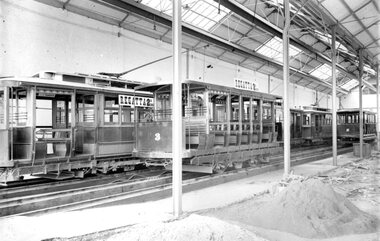 Ballarat Tramway Museum
Photograph - Geelong Tramway Trailers 2 and 3
The remaining trailers 2 and 3 (after Nos 1 and 4 had been motorised) and a line of Duncan & Fraser tramcars in the depot. The broken paving and heaps of sand suggest that the tram shed is being extended to add roads 3 and 4 to the west. That would date the photo as 1914. Regattas were held on the Barwon River at the terminus of the South tramline which was linked directly to the other suburban destinations, Newtown and West Geelong. The standard fare was 3d cash or, for some shorter "sectional" journeys, pre-paid 2d tickets. The sign advertising an event on the river indicates that no matter where passengers alighted, the concession fare was 2d, to be paid in cash rather than by ticket whose detailed sections were irrelevant.Black and white print on paper.No. 3 inside a circle written on reverse in pen. 13-13 and GRS710/17/1/13 written on the reverse in pencil.geelong tramway trailers no. 2 & 3, tram fares in geelong 1914 -
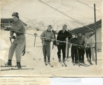 Kiewa Valley Historical Society
Photographs – Skiers at Falls Creek – Set of 10 black and white photographs
After World War II, the Kiewa Hydro-Electric Scheme was started in the Kiewa River valley by the State Electricity Commission of Victoria. On land previously used only for summer cattle grazing in the natural alpine grasslands, the first ski lodge was built in 1948 by workers from the hydro scheme as skiing was a popular recreation. Many of the hydro employees were of European background and had grown up enjoying skiing and snow sports in their homelands and were keen to continue to pursue their winter sports interests. The first lift, a rope tow, was built in 1951 and the first chairlift in Australia was constructed there in 1957. Two T-Bars were opened in 1961. In 1964, the Victorian Municipal Directory recorded that Falls Creek had 29 ski club lodges and 16 commercial lodges.Employees of the State Electricity Commission of Victoria in the Kiewa River Valley were the earliest skiers on the Bogong High Plains and built one of the first ski lodges at Falls Creek. They were amongst those pivotal in the development of the skiing and tourist industry at Falls Creek and on the Bogong High Plains. Set of 10 black and white photographs of various skiers at Falls Creek Victoria1. From Left-John Robertson Myrtleford; Bill Bridgford, St Trinians; Girl not known; Roy Wolpole, Myrtleford; Fin McAuliffe, Myrtleford; Looking on foreground, Toni St Elmo 2. Falls Creek. Property of State Electricity Commission of Victoria Publicity Photo Negative No PB4046. Publicity Branch, 15 William St Melbourne. 3. Avic Lajons 4. No markings 5. Bill Bridgeford (lower person on slope) 6. Max Lawrence? Facing skiers 7. 6575. Indistinguishable red stamp on back 8. 6875. Ces Dobson on tractor 9. From left on tow. John Robertson (Myrtleford); Bill Bridgeford (St Trinians); Girl unknown; Roy Walpole (Myrtleford); Vin McAuliffe (Myrtleford); Looking on foreground Toni Beveridge. 10. From Left 1; 2; 3. Bill Bridgeford; 4. George McPherson ? (Myrtleford); 5. John Robertson (Myrtleford); 6. Elsbeth Rollenson? (Myrtleford); 7; 8; 9. 11. Bogong. Looking N.E from Big River fire track. Skiers on way to Falls Creek. Spion Kop on left. Going around Ropers Cerner near the 18 mile post falls creek, skiing, bogong high plains -
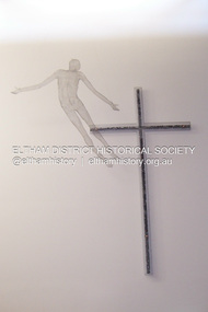 Eltham District Historical Society Inc
Photograph - Digital Photograph, Marguerite Marshall, Resurrection of Christ. Altarpiece, Charles Rocco (2002); Our Lady Help of Christian's Church, Henry Street, Eltham, 11 October 2006
This alterpiece by Charles Rocco was created with wire mesh, river stones and copper. 500 x 200 x 150cm. It was commissioned by the Catholic parish in Eltham (Our Lady Help of Christian's) in 2002 Published: Nillumbik Now and Then / Marguerite Marshall 2008; photographs Alan King with Marguerite Marshall.; p81This collection of almost 130 photos about places and people within the Shire of Nillumbik, an urban and rural municipality in Melbourne's north, contributes to an understanding of the history of the Shire. Published in 2008 immediately prior to the Black Saturday bushfires of February 7, 2009, it documents sites that were impacted, and in some cases destroyed by the fires. It includes photographs taken especially for the publication, creating a unique time capsule representing the Shire in the early 21st century. It remains the most recent comprehenesive publication devoted to the Shire's history connecting local residents to the past. nillumbik now and then (marshall-king) collection, art, our lady help of christian’s church, charles rocco, eltham, resurrection of christ, sculpture -
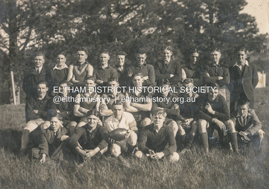 Eltham District Historical Society Inc
Photograph, Diamond Creek Football Club, c.1906
Thomas Edmund Fielding (1874-1957) was a significant member of the Diamond Creek Footbal Club during the early 1900s. Son of Robert Fielding (1820-1891) and Jemima Whatmough (1840-1926) and grandson of Plenty River pioneers Robert Whatmough (1815-1887) and Mary Hill (1813-1881)diamond creek football club, thomas edmund fielding, tom fielding collection, sports -
 Eltham District Historical Society Inc
Medal, Medal; Diamond Creek Football Club (DCFC), 1906
Thomas Edmund Fielding (1874-1957) was a significant member of the Diamond Creek Footbal Club during the early 1900s. Son of Robert Fielding (1820-1891) and Jemima Whatmough (1840-1926) and grandson of Plenty River pioneers Robert Whatmough (1815-1887) and Mary Hill (1813-1881)Inscribed on front: D.C.F.C. Inscribed on reverse: "PRESENTED TO E. Fielding FOR SERVICES RENDERED TO THE CLUB 1906."diamond creek football club, thomas edmund fielding, tom fielding collection, sports -
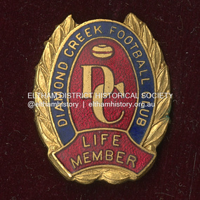 Eltham District Historical Society Inc
Medal - Badge, Diamond Creek Football Club Life Member, c.1906
Thomas Edmund Fielding (1874-1957) was a significant member of the Diamond Creek Footbal Club during the early 1900s. Son of Robert Fielding (1820-1891) and Jemima Whatmough (1840-1926) and grandson of Plenty River pioneers Robert Whatmough (1815-1887) and Mary Hill (1813-1881)diamond creek football club, thomas edmund fielding, tom fielding collection, sports -
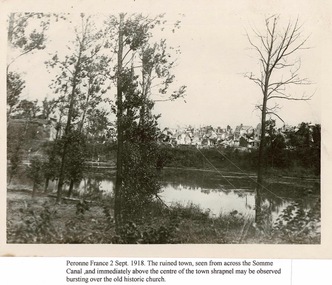 Lara RSL Sub Branch
Sepia Photograph, Photograph of Peronne France 2nd Sept.1918
Between 31 August and 2 September 1918, Australia's Second Division attacked and captured the German stronghold of Mont St Quentin, the key to the strategic town of Péronne on the Somme River. Tired and under strength, units such as the 21st Battalion skilfully drove the enemy from their well-established positions,This photograph shows the aftermath of fighting in Peronne.Rectangular shaped Sepia Photograph.Peronne France 2 Sept. 1918. The ruined town,seen from across the Somme Canal.Immediately above the centre of town shrapnel may be observed bursting over the old historic church.ww1, peronne france, lara r.s.l. australian 2nd division, mont st quentin.